Movements of marine and estuarine turtles during Hurricane Michael
←
→
Page content transcription
If your browser does not render page correctly, please read the page content below
www.nature.com/scientificreports
OPEN Movements of marine
and estuarine turtles
during Hurricane Michael
Margaret M. Lamont1*, Darren Johnson2 & Daniel J. Catizone1
Natural disturbances are an important driver of population dynamics. Because it is difficult to observe
wildlife during these events, our understanding of the strategies that species use to survive these
disturbances is limited. On October 10, 2018, Hurricane Michael made landfall on Florida’s northwest
coast. Using satellite and acoustic telemetry, we documented movements of 6 individual turtles: one
loggerhead sea turtle, one Kemp’s ridley sea turtle, three green sea turtles and one diamondback
terrapin, in a coastal bay located less than 30 km from hurricane landfall. Post-storm survival was
confirmed for all but the Kemp’s ridley; the final condition of that individual remains unknown. No
obvious movements were observed for the remaining turtles however the loggerhead used a larger
home range in the week after the storm. This study highlights the resiliency of turtles in response to
extreme weather conditions. However, long-term impacts to these species from habitat changes post-
hurricane are unknown.
Natural disturbances can impact animal populations in many ways including altering community structure1,
displacing individuals2, reducing reproductive o utput3, lowering individual fi
tness4, and changing movement
patterns5. In addition, these events can alter habitat and environmental conditions, which can create suboptimal
conditions for organisms. Because it is difficult to observe wildlife during these events, our understanding of the
strategies that species use to survive or mitigate these disturbances is limited6–10. This knowledge gap hampers
our ability to identify optimal conditions required by imperiled species for survival during extreme events.
On October 10, 2018, Hurricane Michael made landfall near Tyndall Air Force Base on Florida’s northwest
coast. As a Category 5 storm with maximum winds greater than 140 kts, Hurricane Michael was the third most
intense storm to make landfall in the contiguous United States11. Storm surge was estimated at 9–14 ft in Bay and
Gulf Counties, Florida11 and the combination of water and wind resulted in the destruction of man-made struc-
tures and natural habitats. An estimated 39% of longleaf pine habitat in Florida showed immediate impacts from
the storm12 and salinity of wetlands in the region was altered13. Marine habitats may also have been impacted,
which could have negative consequences for the species that rely on them for s urvival14,15.
Northwest Florida’s estuarine and marine systems are rich in natural resources. The dominant feature of the
region is the Apalachicola River, which has the greatest volume of all Florida’s r ivers16. The nutrients deposited
by the river sustain a high biological diversity throughout the region including the highest species density of
amphibians and reptiles on the continent north of M exico17. These reptiles include a variety of turtle species
that inhabit estuarine and marine habitats such as diamondback terrapins (Malaclemys terrapin) and loggerhead
(Caretta caretta), Kemp’s ridley (Lepidochelys kempii) and green sea turtles (Chelonia mydas).
This area is also susceptible to hurricane impacts. Since hurricane records have been kept, the coasts of Mis-
sissippi, Alabama and Northwest Florida have had direct hits by more than one-third of the 273 storms that
have affected the US mainland18. Hurricanes can displace freshwater and terrestrial reptiles19,20 and cause direct
mortality of many s pecies20–22. Understanding the conditions needed for species survival during hurricanes in
this region is critical to population recovery. Using satellite and acoustic telemetry, we documented movements
of four turtle species as Hurricane Michael moved through Northwest Florida (Fig. 1).
Results
Hurricane Michael made landfall approximately 30 km west of SJB on October 10, 2018 at approximately 13:30
local time [Eastern Daylight Time (ET); 17:30 UTC; Fig. 1]. Barometric pressure at landfall was estimated at 919
mb and maximum sustained winds were from the southwest (from approximately 210°) at 140 kts11. The National
1
U.S. Geological Survey, Wetland and Aquatic Research Center, Gainesville, FL 32653, USA. 2Cherokee Nations
Systems Solutions, Contracted to U.S. Geological Survey, Wetland and Aquatic Research Center, Lafayette,
LA 70506, USA. *email: mlamont@usgs.gov
Scientific Reports | (2021) 11:1577 | https://doi.org/10.1038/s41598-021-81234-3 1
Vol.:(0123456789)
www.nature.com/scientificreports/
Figure 1. Hurricane Michael made landfall on October 10, 2018 approximately 15 km west of St. Joseph Bay,
Florida where marine and estuarine turtles were being tracked using satellite and acoustic telemetry (hurricane
data from Bevan et al. 2019). This map (with self-created symbols/shapes/text) was created using ESRI
(Environmental Systems Resource Institute; http://www.esri.com/software/arcgis) ArcMap software, version
10.7.1. Basemap sources include: ESRI, Maxar, GeoEye, Earthstar Geographics, CNES/Airbus DS, USDA, USGS,
AeroGRID, IGN, and the GIS User Community. Hurricane data contributed by Beven et al. (2019).
Scientific Reports | (2021) 11:1577 | https://doi.org/10.1038/s41598-021-81234-3 2
Vol:.(1234567890)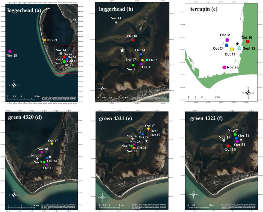
www.nature.com/scientificreports/
Capture First loc/detect Last loc/detect Species Size (cm) Tag type
7/10/2018 7/10/2018 12/3/2018 Terrapin 18.9 Satellite
7/27/2018 7/27/2018 10/8/2019 Loggerhead 76.5 Satellite
9/26/2018 9/28/2018 10/10/2018 Kemp’s ridley 54.6 Satellite
10/4/2018 10/11/2018 6/22/2019 Green 40.3 Acoustic
10/4/2018 10/4/2018 5/17/2019 Green 39.0 Acoustic
10/4/2018 10/5/2018 5/14/2019 Green 34.0 Acoustic
Table 1. Capture, tag transmission and size information for turtles tracked in Northwest Florida during
Hurricane Michael in October 2018. Capture date of capture and tagging, first loc/detect date the first location
or detection from the tag was documented, last loc/detect date the last location or detection from the tag was
documented, species turtle species, size straight carapace length in cm, tag type whether the individual was
tracked via satellite or acoustic tag.
Weather Service suggested the storm was still intensifying as it made landfall11. Barometric pressure dropped
from 1133 mb on October 1 to 1020 mb on October 2 and then again to 1014 mb on October 8 as the storm
entered the southern GoM11 (see Fig. 1). One loggerhead (July 27, 2018), one Kemp’s ridley (September 26, 2018)
and one diamondback terrapin (July 10, 2018) were captured and satellite tagged in SJB prior to the hurricane
(Table 1). All three individuals were carrying active satellite tags during the storm. In addition, three green turtles
were captured and tagged on October 4, 2018 and were carrying active acoustic tags during the storm (Table 1).
Using size as an estimator of life-stage23–25, the loggerhead was a large juvenile, the Kemp’s ridley was either a
large juvenile or an adult female, and the green turtles were juveniles. The terrapin was an adult female. Because
terrapins are highly exploited in the commercial pet t rade26,27, and providing location data through publication
of research results can direct poachers to capture sites28, we chose not to present specific location data for the
terrapin tracked during this study. We believe that information is not necessary to understand the movement
patterns of this individual during the storm.
The last location received for the Kemp’s ridley was on October 10, 2018 at 22:26 ET which is approximately
9.0 h after hurricane landfall (Table 1). The last location received from the terrapin was on December 3, 2018
which is 56 days after landfall. The loggerhead’s tag continued transmissions until July 2019 and the green turtles
were still being detected > 6 months after hurricane landfall.
Locations during landfall. Locations were received from the loggerhead’s tag approximately 5 h before,
2 h before and 6 h after landfall (Fig. 2). The Kemp’s ridley tag transmitted approximately 21 h before and 6 h
after landfall. Three additional locations were then received 7–9 h after landfall; those three locations represent
the final transmissions from the tag. The terrapin tag transmitted 4 h before and 27 h after landfall.
Although tagged on October 4, the first detection of green turtle 4320’s tag was approximately 19 h after
hurricane landfall (Fig. 2). Green turtle 4321’s tag was detected before hurricane landfall on October 6 and then
approximately 23 h after landfall. Green turtle 4322’s tag was also detected before landfall on October 6 but was
not detected again until 47 h (October 12) after landfall.
Home ranges. Home range centroids for the loggerhead, terrapin and green turtle 4321 for the week imme-
diately after hurricane landfall (Oct 10) were located north or northeast of the turtle’s original capture location
(Fig. 3). The centroid for green turtle 4322 was located southwest of the turtle’s capture location and green turtle
4320 had no data available for that week.
Home range sizes varied among individuals (Table 2) with the largest home range exhibited by green turtle
4320 (mean 4.45; SD 4.330; range 0.004–11.180) and the smallest by the terrapin (mean 0.525; SD 0.867; range
0.003–3.191). Home range sizes also varied among weeks for each individual (Supplemental Figure 1). The log-
gerhead used a larger home range the week after the storm than in all of the previous weeks (but not subsequent
weeks; see Discussion). For the remaining turtles, there were no obvious changes in home range sizes in the
weeks immediately before or after Hurricane Michael (Table 2).
Discussion
The long-term effects of Hurricane Michael on Northwest Florida habitats are still unknown. Despite the record-
breaking winds and extreme storm surge, tags on five of the six turtles tracked during landfall continued trans-
missions post-storm thereby confirming turtle survival. There are multiple strategies that turtles utilize to survive
during and after extreme weather events including altering dive behavior, increasing home range size and shifting
habitat use29–31. These studies have typically involved larger samples s izes30 or have documented long-distance
movements31. The turtles tracked in SJB during Hurricane Michael showed no large-scale movements or changes
in behavior in response to the storm. Individual variation in hurricane response for hawksbill sea turtles30, and
other reptiles such as a lligators32 has been documented. This includes some individuals that show no obvious
response32. Our results suggest turtles in SJB responded little, at least with obvious and/or large-scale move-
ments, to the storm both before and after landfall. Our small sample sizes, paired with limitations of non-GPS
capable satellite tags in identifying fine-scale movements33 and the potential impacts of shallow and rough water
on acoustic receiver d etections34, make it difficult for us to confirm fine-scale changes in behavior. In addition,
Scientific Reports | (2021) 11:1577 | https://doi.org/10.1038/s41598-021-81234-3 3
Vol.:(0123456789)www.nature.com/scientificreports/
Figure 2. Raw locations/detections for a Kemp’s ridley (a), loggerhead (b) and diamondback terrapin (c)
that were carrying satellite tags and three green turtles (d–f) that were carrying acoustic tags in St. Joseph
Bay, Florida when Hurricane Michael made landfall at approximately 14:00 h (EDT) on October 10, 2018
in Northwest Florida. The star represents the capture location (with capture date) for each turtle (except for
the Kemp’s ridley which is marked by a pink circle). Triangles (regardless of color) show locations of acoustic
receivers (R# is the receiver identifier). The location of receiver 3 (R3) is included in the Kemp’s ridley and
loggerhead map for reference. Green circles represent locations/detections in the days prior to the storm;
all previous locations (except filtered locations; see Methods) for the Kemp’s ridley are included. Red icons
represent the last available location/detection for each turtle immediately prior to hurricane landfall. Blue icons
represent the first available location/detection available for each turtle immediately after hurricane landfall.
Yellow icons represent locations/detections in the day(s) after landfall occurred. Dates and times (in ET) for
these locations/detections are also included. The arrow indicates wind direction during hurricane landfall.
Because terrapins are an exploited species, and specific location data would reveal capture locations, we chose
not to display these details on a satellite image. These maps (with self-created symbols/shapes/text) were created
using ESRI (Environmental Systems Resource Institute; http://www.esri.com/software/arcgis) ArcMap software,
version 10.7.1. Basemap sources for all Figures, except c (terrapin), include: Esri, Maxar, GeoEye, Earthstar
Geographics, CNES/Airbus DS, USDA, USGS, AeroGRID, IGN, and the GIS User Community. The basemap
source for Figure c is the Florida Fish and Wildlife Research Institute (https://myfwc.com/research/gis/).
Hurricane data contributed by Beven et al. (2019).
it is difficult to say if behaviors observed in this study (e.g. larger home range used by the loggerhead after the
storm) were in response to the storm or some other factor. We recognize these limitations however, we agree
with Sergio et al.35 that “it is ever more urgent and fundamental to increase our knowledge of species responses
to disturbance, especially to predict potential future responses by endangered organisms”.
Kemp’s ridley. Because the satellite tag on the Kemp’s ridley stopped transmitting approximately 5 h after
hurricane landfall, the fate of this individual is unknown. There are many reasons why satellite tags stop trans-
Scientific Reports | (2021) 11:1577 | https://doi.org/10.1038/s41598-021-81234-3 4
Vol:.(1234567890)www.nature.com/scientificreports/
Figure 3. Weekly home range centroids for turtles carrying a satellite tag [loggerhead (a, b), terrapin (c);
Minimum Convex Polygon] or an acoustic tag [green turtles (d–f); Kernel Density Estimation] during
Hurricane Michael in St. Joseph Bay, Florida. Due to a lack of data, home range maps are not provided for the
Kemp’s ridley. The storm made landfall on October 10, 2018; the centroid for the week of October 10 (October
10–16) is shown by a red dot. All weekly centroids for the loggerhead are shown on the left (a) and a close-up
of loggerhead centroids on the right (red square; shown in b) immediately before, during and after the storm.
Capture locations for each individual are denoted with a star. If weekly centroids are not included on the map,
it is due to gaps in data. Because terrapins are an exploited species and providing exact locations for individuals
may contribute to poaching, we chose not to display locations on satellite imagery. These maps (with self-created
symbols/shapes/text) were created using ESRI (Environmental Systems Resource Institute; http://www.esri.com/
software/arcgis) ArcMap software, version 10.7.1. Basemap sources for all Figures, except c (terrapin), include:
Esri, Maxar, GeoEye, Earthstar Geographics, CNES/Airbus DS, USDA, USGS, AeroGRID, IGN, and the GIS
User Community. The basemap source for Figure c is Florida Fish and Wildlife Conservation Commission-Fish
and Wildlife Research Institute (https://myfwc.com/research/gis/).
mitting including tag malfunction (e.g. salt-water switch), battery life, antenna damage or animal mortality36.
The satellite tag was deployed on the Kemp’s ridley in SJB only two weeks before the hurricane and outputs from
the tag showed strong battery, no signs of biofouling, and no salt-water switch failures. When sea turtles die,
they quickly sink37. The abrupt cessation of tag transmissions soon after landfall could indicate mortality or tag
damage. Unfortunately, it is difficult to discriminate between those two possible e vents36.
Typically, juvenile Kemp’s ridleys inhabit nearshore, shallow w aters38–40. From 2013 to 2017, seven juve-
nile Kemp’s ridleys were tracked in SJB; those individuals established home ranges that were within 1.5 km of
shore and in relatively shallow water (mean 3.6 m). In the weeks prior to hurricane landfall, a Harmful Algal
Bloom (HAB) of the toxic dinoflagellate Karenia brevis impacted the northwest Florida coast (https://ocean
service.noaa.gov/hazards/hab/florida-2018.html). Termed “red tide” events, these HAB’s cause disproportion-
ate mortality to Kemp’s ridleys as compared to green turtles and loggerheads and exposure to brevetoxins can
Scientific Reports | (2021) 11:1577 | https://doi.org/10.1038/s41598-021-81234-3 5
Vol.:(0123456789)www.nature.com/scientificreports/
Loggerhead Kemp’s ridley Terrapin Green 4320 Green 4321 Green 4322
7/18 – – 0.105 – – –
7/25 – – 0.281 – – –
8/1 – – – – – –
8/8 – – 0.346 – – –
8/15 0.155 – 0.733 – – –
8/22 0.180 – 0.062 – – –
8/29 0.022 – – – – –
9/5 0.175 – – – – –
9/12 0.096 – 0.110 – – –
9/19 0.057 – – – – –
9/26 0.179 2.963 – – – –
10/3 0.093 0.983 – – 1.578 –
10/10 0.548 – 0.236 0.010 1.578
10/17 0.042 – 0.571 4.606 0.876 0.010
10/24 0.190 – 0.231 7.387 11.989 0.876
10/31 0.033 – 0.427 0.066 1.213 11.989
11/7 0.065 – – 3.432 0.777 1.213
11/14 1.215 – – 0.004 1.339 0.777
11/21 9.483 – – 11.177 4.464 –
11/28 7.453 – 0.003 – 2.116 –
Mean 1.160 1.973 0.302 4.445 2.707 2.741
SD 2.700 1.400 0.220 4.334 3.697 4.561
Table 2. Weekly home range sizes (km2) for a satellite-tagged loggerhead, Kemp’s ridley and diamondback
terrapin (MCPs), and three acoustic-tagged green turtles (KUDs) in St. Joseph Bay, Florida in 2018. The date
in the first column represents the start of the week (e.g. 7/18 = July 18—July 24). Category 5 Hurricane Michael
made landfall in Northwest Florida on October 10, 2018 and the week after storm landfall (October 10 –
October 16) is highlighted in italics.
result in neurological impairment in sea turtles37,41. This HAB may have impacted the Kemp’s ridley’s behavior
during our tracking period.
Loggerhead. The loggerhead we tracked during Hurricane Michael appeared to remain in relatively shallow
water throughout the storm and was near the water’s surface within two hours of hurricane landfall. Loggerheads
are strong swimmers and can maintain their position despite high winds and storm c urrents42–45 however our
results suggest that even in Category 5 winds, loggerheads are able to not only survive but to remain in place in
relatively shallow water.
In the week after the storm, the loggerhead used a larger home range that included deep water north of her
capture location (see Supplemental Figure S1). Short-term (i.e. weekly) expansions in space-use following envi-
ronmental perturbations have been documented for many species35 including hawksbill sea turtles30 and may
reflect increased foraging effort required after disturbances or use of new resting l ocations30. The expanded area
used the week after the storm was also used by the loggerhead during the weeks of November 14 and 21. At this
time, the loggerhead began moving north and by the end of November, the turtle was out of SJB. These November
movements were in response to falling temperatures, which have been previously documented for loggerheads
in SJB46. Mean air temperatures [recorded at the National Oceanographic and Atmospheric Administration’s
weather buoy (APCF1) located approximately 30 km east of SJB], dropped from 21.5 °C (Nov 8–14), to 17.6 °C
(Nov 15–21) and then even further to 13.8 °C (Nov 22–28) during this time period. It is well reported that log-
gerheads use deep water as a thermal refuge46–48 and this expanded area may have also served as a post-storm
refuge for the loggerhead immediately after Hurricane Michael.
Terrapin. The diamondback terrapin is the smallest of all species tracked during the hurricane however this
individual did not appear to be impacted during the storm’s passage. While displacement of aquatic turtles, such
as wood turtles (Glyptemys insculpta) and Johnstone River snapping turtles (Elseya irwini), has been documented
during extreme flooding, the majority of individuals in these studies were not impacted by the fl oods20,49,50. It has
been suggested that individuals bury themselves or remain on the bottom in deep water to avoid extreme surface
currents20 and this may have been the strategy utilized by the terrapin in SJB. We received a high-quality location
(LC 3) approximately 2.5 h before and then again 18 h after hurricane landfall, which suggests the terrapin was
at the water’s surface or on land at those times. Many turtles, including terrapins, are able to remain submerged
for long periods of time through aquatic respiration or regulation of metabolism51,52. It is likely the terrapin in
SJB remained submerged or buried through hurricane landfall to avoid displacement from winds and currents.
Scientific Reports | (2021) 11:1577 | https://doi.org/10.1038/s41598-021-81234-3 6
Vol:.(1234567890)www.nature.com/scientificreports/
The week after the storm however the terrapin’s home range centroid was approximately 1.5 km east (i.e.
landward) of any other weekly centroid we calculated, but this did not correspond to an increase in home range
size. Although reptiles are occasionally displaced by storms those dislocations are typically farther (i.e. tens of
kilometers) than the small distance (~ 1.5 km) observed here2,19,49. Flooding from SJB eastward was severe during
and immediately after Hurricane Michael11 and this may have pushed the terrapin landward. As flood waters
receded, she could have returned to her usual location near her capture site where she was documented the fol-
lowing week (October 17). However, this small shift in centroid location may also simply reflect variability in
Argos locations. Regardless of whether the terrapin moved after landfall, terrapins in SJB did not appear to suf-
fer significant consequences from the storm. After several hurricanes impacted the Florida Keys, few mangrove
terrapins (Malaclemys terrapin rhizophorarium) were captured and it took several years for terrapins to return53;
whereas, 6 days after Hurricane Michael, we captured two adult male terrapins in SJB, and within three weeks
we captured an additional 17 individuals, including 6 females.
Green turtles. None of the tagged green turtles were detected on any receivers for several days immediately
before and during the storm. We had acoustic receivers placed throughout most of the southern end of the bay,
although receivers were spaced far enough apart (ex: 1200 m in some cases) where gaps were available. Therefore,
the tagged green turtles could have either remained in the southern end of the bay but in undetectable areas or
moved out of the array during this time period. Unfortunately, we do not have the data to answer this question.
Both of the green turtles that were detected the day after the storm (October 11; 4320 and 4321) were located
at the most northerly receiver (R3). Perhaps the green turtles moved north into deeper waters where they
were undetected. Similar to loggerheads, green turtles in SJB use deep water as a thermal refuge during cold
temperatures46,54 and these same areas may have also been used as a refuge during Hurricane M ichael30. Again,
without acoustic detections during the storm, it is impossible to know for sure how these individuals responded.
After the storm passed, the turtles traveled back to their original capture location, with turtles 4321 and 4322
arriving by October 12 and turtle 4320 arriving by October 21.
Interestingly, Matley et al.30 reported that larger hawksbills did not shift habitat use after Hurricanes Irma
and Maria. In our study, the green turtles (range 34.0–40.3 cm SCL) were much smaller than the loggerheads
(76.5 cm SCL) however none of these individuals displayed obvious shifts in habitat use. Larger individuals may
be more resilient to environmental p erturbations30,55 due to increased energy reserves, competition or simple
physical strength. For example, a 150 kg loggerhead may be less susceptible to dislocation from storm surge
than a 6 kg green turtle. In SJB, not even the terrapin, which was the smallest turtle we tracked during the storm
(0.98 kg), was clearly impacted by the storm. However, terrapins, unlike sea turtles, are able to bury themselves
completely in response to environmental perturbations. It has been suggested that sea turtles bury themselves
in sediment during periods of extreme cold56 but it is more likely that turtles simply rest on the seafloor for
extended periods rather than actually bury themselves47,57. The ability of terrapins to utilize hibernacula as a
refuge during extreme weather conditions most likely explains the lack of obvious impacts we observed for the
small terrapin during Hurricane Michael.
Although we have confirmation that most of the turtles we tracked during the storm survived, long-term
impacts from the hurricane may still affect these individuals20. Population declines in various species, including
aquatic turtles, have been linked to habitat alterations caused by hurricanes58,59. Seagrass and salt marsh habitat
used by loggerheads, Kemp’s ridleys, green turtles and terrapins may be altered by storms, although these impacts
appear to be site- or storm-specific60,61. Seagrass habitat in Alabama was unaffected by Hurricane Katrina whereas
habitat in the Florida Keys experienced significant damage from Hurricane G eorges60. Challener et al.61 found no
post-storm impacts to seagrass-associated, sea urchin populations in SJB immediately after Hurricane Michael
and reported no evidence that the seagrass was impacted. The results of our opportunistic study highlight the
resiliency of marine and estuarine t urtles62,63. More research on hurricane response by marine and estuarine
turtles is needed, particularly for Kemp’s ridleys as the individual in our study was the only turtle that may not
have survived.
Methods
Turtle tagging. St. Joseph Bay (SJB), located in Northwest Florida in the northern Gulf of Mexico (GoM;
Fig. 1), covers approximately 26,000 ha and is surrounded by mostly undeveloped land and the small town of
Port St. Joe (population 350064). It has a mean depth of 7 m64. Seagrass beds cover approximately one-sixth of the
bay (4000 ha) and are most abundant in the southern end64. Barometric pressure, wind speed and direction data
were downloaded from NOAA C-MAN station (APCF1; https://www.ndbc.noaa.gov/station_page.php?stati
on=APCF1) located approximately 32 km east of St. Joseph Bay.
Turtles were captured in SJB from July through October 2018 (Table 1) using a set net (green turtle) or by
hand (terrapin, loggerhead, Kemp’s ridley). All sea turtles were individually marked with a metal Inconel tag
placed along the trailing edge of each front flipper and a Passive Integrated Transponder (PIT) tag placed sub-
cutaneously in the left shoulder. The terrapin received a PIT tag inserted behind the left bridge, and its carapace
was notched. All turtles were measured using two methodologies: (1) straight carapace length (SCL) and width
(SCW) using calipers and (2) curved carapace length (CCL; measured from the nuchal notch to the tip of the left
pygial scute) and width (CCW) using a cloth tape measure. Turtles were also weighed using a hand-held Pesola
(Kapuskasing, Ontario, Canada) spring scale.
All turtle capture, handling and sampling methods were carried out in accordance with relevant guidelines
and regulations described by the National Marine Fisheries Service (permit #17183) and Florida Fish and Wildlife
Conservation Commission (permits #094, #33447). All experimental protocols were approved by USGS Institu-
tional Animal Care protocols (Protocol USGS/WARC/GNV 2019-15; USGS/WARC/GNV 2018-04).
Scientific Reports | (2021) 11:1577 | https://doi.org/10.1038/s41598-021-81234-3 7
Vol.:(0123456789)www.nature.com/scientificreports/
Satellite tags were fitted to the anterior portion of the carapace using a cool-setting epoxy (Superbond; FCGE
Fiberglass Coatings, Inc, St. Petersburg, Florida) and following established protocols65. The terrapin received
a SPOT-387 tag, the loggerhead received SPOT-287 tag, and the Kemp’s ridley was carrying a SPLASH10 tag
(Wildlife Computers, Redmond, WA). We ensured that the total weight of the satellite tag and epoxy on all tur-
tles did not exceed 5% of the individual’s body weight. Prior to satellite tag attachment, we removed epibionts,
sanded the attachment site and cleaned it with isopropyl alcohol. We streamlined the attachment materials to
reduce drag on the turtle66. All tagged turtles were released at or near their capture location. Each tag was set to
be active for 24 h d −1.
In July 2018, we placed nine VR2W acoustic receivers (Innovasea; Bedford, Nova Scotia, Canada) throughout
the southern portion of SJB (see Fig. 2). Receivers were attached to permanent channel markers using plastic
electrician zip-ties. Green turtles were captured on October 4, 2018 and fitted with V13 coded acoustic transmit-
ters (Innovasea; 6 g in water; 13 mm diameter × 36 mm length) on the right rear marginal scute of the carapace.
Acoustic transmitters were attached with stainless steel wire fitted through two 3-mm diameter holes drilled in
the marginal scutes. Location of transmitters did not interfere with flipper movements. A small amount of epoxy
was placed under and then over the transmitter for additional adhesion. Receivers were downloaded after the
storm on December 5, 2018.
Data analysis. We calculated home ranges, along with home range centroids, for each turtle on a weekly
basis. Weekly analyses were chosen based on data availability and following Matley et al.30. Satellite data were
filtered by location class prior to analyses. We included location classes (LC) 3, 2, 1, 0, A, and B and rejected LC
Z for which no error estimation was available. Argos assigns accuracy estimates of 250 m for LC 3, 250 to 500 m
for LC 2, 500 to 1500 m for LC 1, and 1500 m for LC 067. The estimated accuracy is unknown for LCs A and B
(but these LCs can be useful; see68,69), and locations failing the Argos plausibility tests are tagged as class LC Z.
Kalman-filtering of location data was performed by Argos. Kalman-filtering algorithm provides more estimated
positions and significantly improves position accuracy, most significantly for locations obtained in LCs A and
B70.
We used State Space Modeling (SSM) approach to calculate home ranges (but not estimate behavioral state),
following Hart et al.33. We applied a model used by Breed et al. 71, which is a modified version of a model
described by Jonsen et al.72 that estimates model parameters by Markov Chain Monte Carlo (MCMC) using JAGS
via the software program R. We fit the model to data for each individual turtle to estimate location every day from
five independent and parallel chains of MCMC samples. Our samples from the posterior distribution were based
on 3,000 samples after a burn-in of 7000 samples and thinning the remaining samples by twenty. If convergence
wasn’t reached, we increased the sample size to 6,000. We used the psrf < 1.1 as a measure of convergence.
Home ranges were calculated for all individuals using the SSM location data during each week using Multiple
Convex Polygon (MCP)70,73 or Kernel Density Estimation (KDE)72,74 in R (package a dehabitatHR75) depend-
ing on data availability. For individuals that had between 5 and 19 locations MCP was used whereas KDE was
used for individuals with ≥ 20 locations. Weeks were defined based on hurricane landfall (October 10, 2018 at
approximately 13:30 EDT). Hence the first week before the hurricane ranged from October 3 to October 9 and
all preceding and subsequent weeks followed (e.g. week after the hurricane October 10–October 16).
In ArcMap (v10.7.1) we plotted turtle locations to document movements in the days surrounding hurricane
landfall. We plotted the following locations, depending on data availability: (1) the day(s) prior to landfall, (2)
the most recent location immediately before landfall, (3) the most recent location immediately after landfall and
(4) the day(s) after landfall. For the Kemp’s ridley, we plotted all available locations after filtering out obvious
erroneous locations. Erroneous locations were defined as those that were > 2 km into the GoM or on l and76.
We calculated weekly home range size (km2) and home range centroids for the temporal extent possible for
each individual. We mapped centroid locations for the week immediately prior to landfall (October 3) through
November 28. If data were not available for a turtle for that entire time period, we used the temporal extent
of available data. We chose November 28 as the cut off for mapping centroid locations because sea turtles in
SJB typically move out of the bay and into deeper waters in the GoM in mid to late November46. Terrapins also
become less active and presumably enter hibernacula when temperatures drop77 although data on over-wintering
behavior by terrapins in Northwest Florida are lacking.
Received: 8 June 2020; Accepted: 29 December 2020
References
1. Elliser, C. R. & Herzing, D. L. Replacement dolphins? Social restructuring of a resident pod of Atlantic bottlenose dolphins, Tursiops
truncatus, after two major hurricanes. Mar. Mammal Sci. 27, 39–59 (2011).
2. Elsey, R. M. & Aldrich, C. Long-distance displacement of a juvenile alligator by Hurricane Ike. Southeast. Nat. 8, 746–749 (2009).
3. Jones, J., DeBruyn, R. D., Barg, J. J. & Robertson, R. J. Assessing the effects of natural disturbance on a Neotropical migrant songbird.
Ecology 82, 2628–2635 (2001).
4. Swilling, W. R., Wooten, M. C., Holler, N. R. & Lynn, W. J. Population dynamics of Alabama beach mice (Peromyscus polionotus
ammobates) following Hurricane Opal. Am. Midl. Nat. 140, 287–298 (1998).
5. Heupel, M. R., Simpfendorfer, C. A. & Hueter, R. E. Running before the storm: blacktip sharks respond to falling barometric pres-
sure associated with Tropical Storm Gabrielle. J. Fish Biol. 63, 1357–1363 (2003).
6. Cannizzo, Z. J. & Griffen, B. D. Habitat-specific impacts of Hurricane Matthew on a range-expanding species. Hydrobiologia 809,
79–89 (2018).
7. Gunzburger, M. S., Hughes, W. B., Barichivich, W. J. & Staiger, J. S. Hurricane storm surge and amphibian communities in coastal
wetlands of northwestern Florida. Wetl. Ecol. Manag. 18, 651–663 (2010).
Scientific Reports | (2021) 11:1577 | https://doi.org/10.1038/s41598-021-81234-3 8
Vol:.(1234567890)www.nature.com/scientificreports/
8. Lawes, M. J., Adie, H., Russell-Smith, J., Murphy, B. & Midgley, J. J. How do small savanna trees avoid stem mortality by fire? the
roles of stem diameter, height and bark thickness. Ecosphere 2, 1–13 (2011).
9. Lytle, D. A., Bogan, M. T. & Finn, D. S. Evolution of aquatic insect behaviours across a gradient of disturbance predictability. Proc.
R. Soc. B Biol. Sci. 275, 453–462 (2008).
10. Schwilk, D. W. & Ackerly, D. D. Flammability and serotiny as strategies: correlated evolution in pines. Oikos 94, 326–336 (2001).
11. Beven II, J. L., Berg, R. & Hagen, A. National hurricane center tropical cyclone report: Hurricane Michael (AL142018). Natl.
Weather Serv. 111 (2019). https://www.nhc.noaa.gov/data/tcr/AL142018_Michael.pdf. Accessed 12 October 2019.
12. Zampieri, N. E., Pau, S. & Okamoto, D. K. The impact of Hurricane Michael on longleaf pine habitats in Florida. bioRxiv https://
doi.org/10.1101/736629 (2019).
13. Walls, S. C. et al. Seeking shelter from the storm: conservation and management of imperiled species in a changing climate. Ecol.
Evol. 9, 7122–7133 (2019).
14. Congdon, V. M., Bonsell, C., Cuddy, M. R. & Dunton, K. H. In the wake of a major hurricane: differential effects on early vs. late
successional seagrass species. Limnol. Oceanogr. Lett. 4, 155–163 (2019).
15. Edmiston, H. L. et al. Tropical storm and hurricane impacts on a Gulf Coast Estuary: Apalachicola Bay, Florida. J. Coast. Res.
10055, 38–49 (2008).
16. Livingston, R. J., Hackney, C. T., Adams, S. M. & Martin, W. Medium-sized rivers of the Gulf Coastal Plain in biodiversity of the
Southeastern United States. In Biodiversity of the Southeastern United States (eds Hackney, C. T. et al.) 351–385 (Wiley, New York,
1992).
17. Couch, C. A., Hopkins, E. H. & Hardy, P. S. Influences of environmental settings on aquatic ecosystems in the Chattahoochee-Flint
River Basin. Water Resour. Investig. Rep. 95–4278, 65 (1996).
18. Blake, E. S., Rappaport, E. N., Landsea, C. W. & Miami, N. The deadliest, costliest, and most intense United States tropical cyclones
from 1851 to 2006 (and other frequently requested hurricane facts)-technical memorandum NWS TPC-5. Natl. Ocean. Atmos.
Adm. (NOAA)—National Hurric. Cent. (NHC), US Dep. Commer. Memo. NWS TPC-5 54, 43 (2007).
19. Censky, E. J., Hodge, K. & Dudley, J. Over-water dispersal of lizards due to hurricanes [7]. Nature 395, 556 (1998).
20. Jones, M. T. & Sievert, P. R. Effects of stochastic flood disturbance on adult wood turtles, Glyptemys insculpta, in Massachusetts.
Can. Field Nat. 123, 313–322 (2009).
21. Massie, J. A. et al. Going Downriver: Patterns and cues in hurricane-driven movements of common snook in a subtropical coastal
river. Estuaries Coasts https://doi.org/10.1007/s12237-019-00617-y (2019).
22. Strickland, B. A. et al. Movements of juvenile bull sharks in response to a major hurricane within a tropical estuarine nursery area.
Estuaries Coasts https://doi.org/10.1007/s12237-019-00600-7 (2019).
23. NMFS & USFWS. Recovery Plan for the Northwest Atlantic Population of the Loggerhead Sea Turtle (Second Revision). National
Marine Fisheries Service (2008).
24. National Marine Fisheries Service, U.S. Fish and Wildlife Service & SEMARNAT. Bi-National Recovery Plan for the Kemp’s Ridley
Sea Turtle (Lepidochelys kempii), Second Revision. Fisheries (Bethesda) (2011).
25. Seminoff, J. A. et al. Status review of the green turtle (Chelonia mydas) under the Endangered Species Act. (2015).
26. Convention on International Trade in Endangered Species of Wild Fauna and Flora. Draft proposal of prohibiting the commercial
trade of diamondback terrapin. (2013).
27. Enge, K. M. et al. What the world needs is a better gopher tortoise trap. Herpetol. Rev. 48, 543–576 (2012).
28. Powell, R. & Henderson, R. W. A new species of Gonatodes (Squamata: Gekkonidae) from the West Indies. Caribb. J. Sci. 41,
709–715 (2005).
29. Wilson, M., Tucker, A. D., Beedholm, K. & Mann, D. A. Changes of loggerhead turtle (Caretta caretta) dive behavior associated
with tropical storm passage during the inter-nesting period. J. Exp. Biol. 220, 3432–3441 (2017).
30. Matley, J. K., Eanes, S., Nemeth, R. S. & Jobsis, P. D. Vulnerability of sea turtles and fishes in response to two catastrophic Caribbean
hurricanes, Irma and Maria. Sci. Rep. 9, 1–15 (2019).
31. Crowe, L. M., Hatch, J. M., Patel, S. H., Smolowitz, R. J. & Haas, H. L. Riders on the storm: loggerhead sea turtles detect and respond
to a major hurricane in the Northwest Atlantic Ocean. Mov. Ecol. 8, 1–13 (2020).
32. Strickland, B. A. et al. Variation in movement behavior of alligators after a major hurricane. Anim. Biotelem. 8, 1–10 (2020).
33. Hart, K. M., Lamont, M. M., Fujisaki, I., Tucker, A. D. & Carthy, R. R. Common coastal foraging areas for loggerheads in the Gulf
of Mexico: opportunities for marine conservation. Biol. Conserv. 145, 185–194 (2012).
34. Swadling, D. S. et al. Seagrass canopies and the performance of acoustic telemetry: implications for the interpretation of fish
movements. Anim. Biotelem. 8, 1–12 (2020).
35. Sergio, F., Blas, J. & Hiraldo, F. Animal responses to natural disturbance and climate extremes: a review. Glob. Planet. Change 161,
28–40 (2018).
36. Hays, G. C., Bradshaw, C. J. A., James, M. C., Lovell, P. & Sims, D. W. Why do Argos satellite tags deployed on marine animals stop
transmitting?. J. Exp. Mar. Bio. Ecol. 349, 52–60 (2007).
37. Foley, A. M. et al. Assessing Karenia brevis red tide as a mortality factor of sea turtles in Florida, USA. Dis. Aquat. Organ. 132,
109–124 (2019).
38. Schmid, J. R. & Witzell, W. N. Seasonal migrations of immature Kemp’s ridley turtles along the west coast of Florida. Gulf Mex.
Sci 24, 27–40 (2006).
39. Seney, E. E. & Landry, A. M. Movement patterns of immature and adult female Kemp’s ridley sea turtles in the northwestern Gulf
of Mexico. Mar. Ecol. Prog. Ser. 440, 241–254 (2011).
40. Coleman, A. T., Pitchford, J. L., Bailey, H. & Solangi, M. Seasonal movements of immature Kemp’s ridley sea turtles (Lepidochelys
kempii) in the northern Gulf of Mexico. Aquat. Conserv. Mar. Freshw. Ecosyst. 27, 253–267 (2017).
41. Fauquier, D. A. et al. Brevetoxin in blood, biological fluids, and tissues of sea turtles naturally exposed to Karenia brevis blooms
in central West Florida. J. Zoo Wildl. Med. 44, 364–375 (2013).
42. Hays, G. C., Lusci, P., Papi, F., Seppia, P. & Marsh, R. Changes in behaviour during the inter-nesting and post-nesting migration
for Ascension Island green turtles. Mar. Ecol. Prog. Ser. 189, 263–273 (1999).
43. Schofield, G. et al. Microhabitat selection by sea turtles in a dynamic thermal marine environment. J. Anim. Ecol. 78, 14–21 (2009).
44. Schofield, G. et al. Inter-annual variability in the home range of breeding turtles: Implications for current and future conservation
management. Biol. Conserv. 143, 722–730 (2010).
45. Pike, D. A. Environmental correlates of nesting in loggerhead turtles, Caretta caretta. Anim. Behav. 76, 603–610 (2008).
46. Lamont, M. M. & Iverson, A. R. Shared habitat use by juveniles of three sea turtle species. Mar. Ecol. Prog. Ser. 606, 187–200 (2018).
47. Hochscheid, S., Bentivegna, F. & Hays, G. C. First records of dive durations for a hibernating sea turtle. Biol. Lett. 1, 82–86 (2005).
48. Hawkes, L. A., Broderick, A. C., Coyne, M. S., Godfrey, M. H. & Godley, B. J. Only some like it hot—quantifying the environmental
niche of the loggerhead sea turtle. Divers. Distrib. 13, 447–457 (2007).
49. Johnston, G. R., Thomas, T. M., Suarez, E., Lau, A. & Mitchell, J. C. Population structure and body size of the suwannee alligator
snapping turtle (Macrochelys suwanniensis) in Northern Florida. Chelonian Conserv. Biol. 14, 73–81 (2015).
50. Freeman, A. B., Eisemberg, C. C. & Stoetzel, H. Habitat use and movements in an upland population of Johnstone River Snapping
Turtles, Elseya irwini. Herpetol. Conserv. Biol. 13, 464–472 (2018).
51. Jackson, D. C. & Ultsch, G. R. Physiology of hibernation under the ice by turtles and frogs. J. Exp. Zool. Part A Ecol. Genet. Physiol.
313 A, 311–327 (2010).
Scientific Reports | (2021) 11:1577 | https://doi.org/10.1038/s41598-021-81234-3 9
Vol.:(0123456789)www.nature.com/scientificreports/
52. Williard, A. S. & Harden, L. A. Seasonal changes in thermal environment and metabolic enzyme activity in the diamondback
terrapin (Malaclemys terrapin). Comp. Biochem. Physiol. A Mol. Integr. Physiol. 158, 477–484 (2011).
53. Mealey, B. K., Baldwin, J. D., Parks-Mealey, G. B., Bossart, G. D. & Forstner, M. R. J. Characteristics of mangrove diamondback
terrapins (Malaclemys Terrapin Rhizophorarum) inhabiting altered and natural mangrove islands. J. N. Am. Herpetol. 2014, 76–80
(2014).
54. Lamont, M. M., Fujisaki, I., Stephens, B. S. & Hackett, C. Home range and habitat use of juvenile green turtles (Chelonia mydas)
in the northern Gulf of Mexico. Anim. Biotelem. 3, 53 (2015).
55. Ozgul, A., Coulson, T., Reynolds, A., Cameron, T. C. & Benton, T. G. Population responses to perturbations: the importance of
trait-based analysis illustrated through a microcosm experiment. Am. Nat. 179, 582–594 (2012).
56. Mendonça, M. T. Movements and feeding ecology of immature green turtles (Chelonia mydas) in a Florida Lagoon. Copeia 1983,
1013–1023 (1983).
57. Lamont, M. M., Seay, D. R. & Gault, K. Overwintering behavior of juvenile sea turtles at a temperate foraging ground. Ecology 99,
2621–2624 (2018).
58. Waide, R. Summary of the response of animal populations to hurricanes in the Caribbean. Biotropica 23, 508–512 (1991).
59. Selman, W. & Qualls, C. The impacts of Hurricane Katrina on a population of yellow-blotched sawbacks (Graptemys flavimaculata)
in the Lower Pascagoula River. Herpetol. Conserv. Biol. 3, 224–230 (2008).
60. Fourqurean, J. W. & Rutten, L. M. The impact of Hurricane Georges on soft-bottom, back reef communities: site- and species-
specific effects in south Florida seagrass beds. Bull. Mar. Sci. 75, 239–257 (2004).
61. Challener, R., McClintock, J. B., Czaja, R. & Pomory, C. Rapid assessment of post-Hurricane Michael impacts on a population of the
sea urchin Lytechinus variegatus in seagrass beds of Eagle Harbor, Port Saint Joseph Bay, Florida. Gulf Caribb. Res. 30, SC11–SC16
(2019).
62. Jergenson, A. M., Miller, D. A. W., Neuman-Lee, L. A., Warner, D. A. & Janzen, F. J. Swimming against the tide: resilience of a
riverine turtle to recurrent extreme environmental events. Biol. Lett. 10, 20130782 (2014).
63. Miller, D. A. W., Janzen, F. J., Fellers, G. M., Kleeman, P. M. & Bronikowski, A. M. Biodemography of ectothermic tetrapods pro-
vides insights into the evolution and plasticity of mortality patterns. Soc. Hierarchy Heal. Comp. Biodemogr. A Collect. Pap. 295,
314. https://doi.org/10.17226/18822 (2014).
64. Florida Department of Environmental Protection. St. Joseph Bay Aquatic Preserve Management Plan (2008).
65. National Oceanic and Atmospheric Administration. Southeast Fisheries Science Center Techniques Manual (2008).
66. Watson, K. P. & Granger, R. A. Hydrodynamic effect of a satellite transmitter on a juvenile green turtle (Chelonia mydas). J. Exp.
Biol. 201, 2497–2505 (1998).
67. CLS. Argos user’s manual: worldwide tracking and environmental monitoring by satellite (2011).
68. Hays, G. C. et al. The importance of sand albedo for the thermal conditions on sea turtle nesting beaches. Oikos 93, 87–94 (2001).
69. Witt, M. J. et al. Assessing accuracy and utility of satellite-tracking data using Argos-linked Fastloc-GPS. Anim. Behav. 80, 571–581
(2010).
70. Lopez, R. & Malarde, J. Improving Argos doppler location using Kalman filtering (2011).
71. Breed, G. A., Jonsen, I. D., Myers, R. A., Don Bowen, W. & Leonard, M. L. Sex-specific, seasonal foraging tactics of adult grey seals
(Halichoerus grypus) revealed by state-space analysis. Ecology 90, 3209–3221 (2009).
72. Jonsen, I. D., Flemming, J. M. & Myers, R. A. Robust state-space modeling of animal movement data. Ecology 86, 2874–2880 (2005).
73. Kalman, R. E. A new approach to linear filtering and prediction problems. J. Basic Eng. 82, 35–45 (1960).
74. Patterson, T., Thomas, L., Wilcox, C., Ovaskainen, O. & Matthiopoulos, J. State-space models of individual animal movement.
Trends Ecol. Evol. 23, 87–94 (2008).
75. Calenge, C. The package adehabitat for the R software: tool for the analysis of space and habitat use by animals. Ecol. Modell. 197,
1035–1041 (2006).
76. Hart, K. M., Lamont, M. M., Sartain, A. R. & Fujisaki, I. Migration, foraging, and residency patterns for Northern Gulf loggerheads:
implications of local threats and international movements. PLoS One 9, e103453 (2014).
77. Harden, L. A., Midway, S. R. & Williard, A. S. The blood biochemistry of overwintering diamondback terrapins (Malaclemys ter-
rapin). J. Exp. Mar. Biol. Ecol. 466, 34–41 (2015).
Acknowledgements
We thank Joseph Alday and Carson Arends for field assistance. The research was conducted under State of
Florida Marine Turtle Permit #094 and Special Use Permit #33447, and National Marine Fisheries Service Permit
#17183. All turtle handling and sampling was performed according to the Institutional Animal Care Protocol
USGS/WARC/GNV 2019-15 and USGS/WARC/GNV 2018-04. Maps throughout this paper were created using
ArcGIS software by Esri. For more information about Esri software, please visit www.esri.com. Any use of trade,
product, or firm names is for descriptive purposes only and does not imply endorsement by the US Government.
Author contributions
M.M.L. developed the concept, assisted with field work and lead the writing of the manuscript. D.J. conducted
statistical analyses, made figures, and assisted with manuscript writing. D.J.C. conducted field work and assisted
with manuscript writing. All authors reviewed and approved the manuscript.
Competing interests
The authors declare no competing interests.
Additional information
Supplementary Information The online version contains supplementary material available at https://doi.
org/10.1038/s41598-021-81234-3.
Correspondence and requests for materials should be addressed to M.M.L.
Reprints and permissions information is available at www.nature.com/reprints.
Publisher’s note Springer Nature remains neutral with regard to jurisdictional claims in published maps and
institutional affiliations.
Disclosure: Any use of trade, product, or firm names is for descriptive purposes only and does not imply
endorsement by the US Government. This draft manuscript is distributed solely for purposes of scientific peer
Scientific Reports | (2021) 11:1577 | https://doi.org/10.1038/s41598-021-81234-3 10
Vol:.(1234567890)www.nature.com/scientificreports/
review. Its content is deliberative and pre-decisional, so it must not be disclosed or released by reviewers. Because
the manuscript has not yet been approved for publication by the US Geological Survey (USGS), it does not
represent any official USGS finding or policy.
Open Access This article is licensed under a Creative Commons Attribution 4.0 International
License, which permits use, sharing, adaptation, distribution and reproduction in any medium or
format, as long as you give appropriate credit to the original author(s) and the source, provide a link to the
Creative Commons licence, and indicate if changes were made. The images or other third party material in this
article are included in the article’s Creative Commons licence, unless indicated otherwise in a credit line to the
material. If material is not included in the article’s Creative Commons licence and your intended use is not
permitted by statutory regulation or exceeds the permitted use, you will need to obtain permission directly from
the copyright holder. To view a copy of this licence, visit http://creativecommons.org/licenses/by/4.0/.
© The Author(s) 2021
Scientific Reports | (2021) 11:1577 | https://doi.org/10.1038/s41598-021-81234-3 11
Vol.:(0123456789)You can also read