NASA sees Tropical Cyclone Narelle approaching Western Australia coast
←
→
Page content transcription
If your browser does not render page correctly, please read the page content below
NASA sees Tropical Cyclone Narelle
approaching Western Australia coast
10 January 2013
coast of Western Australia over the next several
days as Narelle continues to move on a southerly
track, where it is expected to remain at sea, but
parallel the coast.
Current Australian warnings include: a Cyclone
Warning is in effect for coastal areas from Whim
Creek to Coral Bay, including Karratha, Dampier,
Onslow and Exmouth. A Cyclone Watch is in effect
for coastal areas from Coral Bay to Cape Cuvier. A
Blue alert is in effect for the coastal and island
communities from Whim Creek to Mardie, including
Wickham, Roebourne, Point Sampson, Karratha
and DampiFor updated warnings and watches, visit
the Australian Bureau of Meteorology web page:
http://www.bom.gov.au/australia/warnings/index.sht
ml.
This visible image of Tropical Cyclone Narelle was
captured by the MODIS instrument aboard NASA's Aqua
satellite on Jan. 10, 2013, at 0625 UTC. Narelle
developed the tropical cyclone signature shape with a
tight rounded center and bands of thunderstorms
wrapping around. Credit: NASA Goddard MODIS Rapid
Response Team
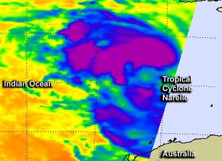
NASA's Aqua satellite looked at Cyclone Narelle in NASA AIRS data of Cyclone Narelle on Jan. 9 at 1811
visible and infrared light to understand the UTC showed that the largest area of powerful
behavior of the storm. NASA's MODIS and AIRS thunderstorms (purple) were around the center, north and
instruments provided those data, respectively, and northwest of the center of circulation, an indication of
where the heaviest rain was falling. Credit: NASA JPL,
they showed that Narelle is gaining strength as it
Ed Olsen
approaches the northern coast of Western
Australia.
Watches and Warnings are posted for the western
When NASA's Aqua satellite passed over Narelle
1/3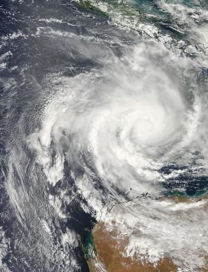
on Jan. 9 at 1811 UTC (1:11 p.m. EST/2:11 a.m. on south, and peak around 115 knots (132.3 mph/213
Jan. 10, local time, Perth, Australia), the            kph) sometime on Jan. 12 before weakening again.
Atmospheric Infrared Sounder (AIRS) instrument
captured data on the storm in infrared light. Infrared New forecast guidance from the Joint Typhoon
light shows temperature, and cloud top                 Warning Center (JTWC) now calls for the west
temperatures can indicate if clouds are reaching       coast of Western Australia to experience Tropical
higher in the atmosphere (strengthening) or lower Cyclone Narelle's rainfall, gusty winds and rough
(weakening). AIRS data showed that the largest         surf. The JTWC forecast now takes Narelle close to
area of powerful thunderstorms were around the         the coast from north of Learmonth to the peninsula
center, north and northwest of the center of           south of Perth, where it is now expected to make
circulation, an indication of where the heaviest rain landfall in the South West region of Western
was falling.                                           Australia on Jan. 15 after tracking south through
                                                       Geographe Bay.
Another that flies aboard NASA's Aqua satellite
called the Moderate Resolution Imaging
Spectroradiometer (MODIS) instrument captured a Provided by NASA's Goddard Space Flight Center
visible image of Tropical Cyclone Narelle as it was
approaching the northern coast of Western
Australia. The image was taken on Jan. 10, 2013 at
0625 UTC (1:25 a.m. EST/2:25 p.m. local time,
Perth, Australia). The MODIS image revealed that
Narelle developed the signature shape of a tropical
cyclone with a tight rounded center and bands of
thunderstorms wrapping into the center.

On Jan. 10 at 1500 UTC (10 a.m. EST/11 p.m.
local time, Perth), Tropical Cyclone Narelle had
maximum sustained winds near 80 knots (92
mph/148.2 kph). It was centered near 16.5 south
latitude and 114.7 east longitude, about 370
nautical miles north of Learmonth, Australia.
Narelle has been moving south-southwest at 10
knots (11.5 mph/18.5 kph). Narelle is churning up
rough seas, as high as 32 feet (9.7 meters), which
will likely cause coastal erosion and flooding.
Narelle is expected to continue moving to the south-
southwest toward Northwest Cape and gradually
intensify.

Infrared imagery, such as what AIRS provides
shows that a new feeder band of thunderstorms
has formed to the south of the center. Infrared data
showed that cloud tops around the center have
cooled, indicating convection (rising air forming the
thunderstorms that make up the cyclone) has
strengthened, and cloud tops are higher and the
storms more powerful. Microwave satellite data,
which can see through clouds, showed that an eye
was forming in the center. The JTWC forecasters
call for Narelle to continue intensifying as it moves

                                                                                                  2/3
APA citation: NASA sees Tropical Cyclone Narelle approaching Western Australia coast (2013, January
                                   10) retrieved 23 April 2021 from https://phys.org/news/2013-01-nasa-tropical-cyclone-narelle-
                                   approaching.html

                                   This document is subject to copyright. Apart from any fair dealing for the purpose of private study or research, no
                                   part may be reproduced without the written permission. The content is provided for information purposes only.

                                                                                                                                                3/3

Powered by TCPDF (www.tcpdf.org)
You can also read