NATURE AND CLIMATE SURVEY GUIDE NOTES 2020
←
→
Page content transcription
If your browser does not render page correctly, please read the page content below
NATURE AND CLIMATE SURVEY GUIDE NOTES 2020
This Nature and Climate survey builds on a pilot carried out in Biodiversity week. Summary of findings including
amazing participant photos, videos and follow up action will be uploaded on World Oceans Day June 8th. See also Irish
Times Kathleen Harris video : https://bcove.video/308ndXA
Nature Alert: Some animals have claimed back coastal spots they found uncharacteristically quiet due to COVID restrictions.
As restrictions are eased, these animals are extra vulnerable. Please scout your shore, looking out for anything vulnerable
and adjust own behaviour and if need be let relevant authorities and Coastwatch know. Some examples where surveyors
acted during the pilot phase will be uploaded as ACTION to protect NATURE and more can be added during this main survey.
SURVEY TIME: This survey starts on World Oceans Day June 8th and runs until the longest day in the year – June 21st.
Both start and end fall on spring tides - the ideal time to survey assuming the weather is reasonable.
METHOD SUMMARY: Select a 500m long shore survey unit (or more) from our Coastwatch website map, go out during
low tide to check the shore with camera and complete a one page survey form, which you print and take with you
or save onto your phone. If there is good WIFI you can also report directly online on a selection of plants, seaweeds
and animals. Otherwise input what you saw straight after your survey and send it by June 22nd.
At present we have no sponsors and no interns but will do our best to sum up and display a snapshot of the beauty and diversity of
our coast, climate change indicators, carbon sinks and stores found. We will also flag threats and give you action advise.

Those who have found seagrass beds, kelp forest and/or propose the shore for special features will be contacted if they would like
to join a features submission for Ireland’s Ireland’s first Marine Spatial Plan (MSP). If sponsorship is secured there are heat wave
watch programmes we would love to roll out in sites where climate change indicators were found.

 A survey unit (s.u. for short) is a stretch of shore approx. 500 m long, as measured along mean high tide mark. On the
 Coastwatch map online it’s any one of the blue or white sections you see along the coast. If you click on one, the colour
 changes to turquoise and the unique survey unit code pops up. That is the code for your survey form.

                                                                                               Spring (extreme) high-tide
  HINTERLAND
                                                                                              Normal high-tide (MHWM)
                             SPLASH
                                                                                                Normal low-tide (MLWM)
                              ZONE
                                                 INTERTIDAL

The width covers the sea shore from Spring High Tide Mark (= start of hinterland) down to shallow water when the tide
is fully out. The intertidal may be over a kilometre in estuaries with sand and mudflats, or reduced to a narrow strip
along steeply sloping shores or a wall. In spring tides (on a full and new moon) you find the widest intertidal.
Before you start plan for COVID.
                                                        It’s perfect when you do it with your family. Just check that:-
                                                             1. you are not disturbing nesting birds or pregnant seals
                                                                  which might have got used to humans staying away.
                                                                   2. the area is clean with no signs of sewage,
                                                              3. there are few people so not much need to practise
                                                                                   social distancing.
INSTRUCTIONS IN DETAIL -
1. CHOOSE YOUR SURVEY AREA
Go to www.coastwatch.org/europe/map, zoom in on a potential survey area and click on any of the blue or white
coloured lines (each one being a 500m survey unit) to get code. Note this code in the first question of the survey form.

   MAP NOTE
   You can access the Coastwatch map with a smart phone when you are in the field if you scan the QR code with
   any QR reader app. But as there may not be internet access it’s better to prepare at home on phone or desktop.

   Getting a good map of your survey area
   Three options to prepare a survey unit map for use on the shore, (e.g. to identify start/finish of your s.u.):
   While you have internet access select your survey area on the Coastwatch Map, in ‘satellite view’. You might
   include 2 or 3 survey units in the view. Then either (1) photograph the map on the computer screen using your
   phone, to consult the photo and zoom in, when you are on the shore. or (2) If you have a smartphone, find the
   map on your phone and take a screenshot, to consult it later. (3) If you know the area well, just jot down the start
   and finish of the su..
   If you experience any problems with the maps please contact survey@coastwatch.org or Karin Dubsky - +353
   (0)86 811 1684. Some regional coordinators have kindly agreed to give support and their contacts will be put on
   the website by the 20th. This time we have no booking option. So to avoid overlap you could agree between
   Coastwatch friends or through social media which areas to cover. Please please at all times remember COVID 19!
2. PLAN AND SURVEY

SURVEY PLANNING HINTS and Timing

Try to start about 1.5 hours before low tide. Check a tide table e.g. www.bit.do/easytide or google ‘low tide with a place.
You would scout the shore first to check that there are no birds nesting or seals hauling out. Common seals pup now.
Then survey around low tide best tides are around the New and Full Moon.
SITES TO SURVEY
If you now have a choice anywhere in your county , or up to 20km from home. The ideal survey unit would have:
    -   One or more important carbon store habitats: – saltmarsh, seagrass, peatbog, kelp forests
    -   Include one or more species vulnerable to overheating (climate change) barnacles, limpets, Corallina seaweed
AVOID: bird nesting, or seal haul out shores and avoid areas with sewage pollution or with recent sanitary materials.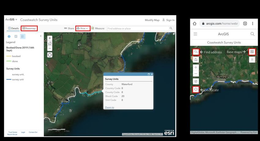
NOTES ON QUESTIONS
Background information
The unique code for each 500m survey unit needs to be filled in as provided on the survey map
     http://coastwatch.org/europe/map/ and follow instructions. Please alert us (survey@coastwatch.org) if you
     notice any map or code problems. Some islands are not coded using this online system yet. Survey anyway.

Splash Zone
Saltmarsh, reed beds and peat bog are valuable Carbon sink and store wetlands which we need to preserve. Photos
      would be most welcome. If you see any damage to these like infill, vehicle or burn marks, or new hard erosion
      control over them please photograph and record in the last question .
Intertidal
HIGHER PLANTS
     You might see a riot of colour created by flowers along your shore. Look, smell, see if there are bees. Take
     photos to share. This first question is to include all ages and give joy. As you share photos of the common sea
     pinks and yellow birds foot trefoils and kidney vetches, the burnet roses and dune violets, there may also be
     orchids and other rarer plants. We will ask can these photos be used in an exhibition and can we give your name
     and site. If it’s a rare plant the site will not be included and your name can also be withheld if you prefer.
      Zostera are silky grasses which live in the sea and are very important carbon stores.
      The little Z. noltii has very thin blades so you can hardly see the veins. Its roots are   Figure2
      anchored in the mud and it lies on the sand/mudflats when the tide is out. It may
      be patchy as in fig 1. It’s the most favoured Brent geese food, so watch out, there
      may be some last straggling geese grazing.
       Zostera marina, fig (2) has two forms: the smaller (phenotype) grows in puddle
      and pool areas of the intertidal as a hand to knee high grass, with wider grass            Figure1
      blades where you see the veins. The longer phenotype grows from low water
      down to 10m depth, depending on water transparency and other factors. It can
      be a meter or more long and is an important feeding, shelter and habitat for fish,
      molluscs, shrimps, sea horses etc. Zostera beds are threatened and if you find one
      it’s a real treasure! You might find Zostera plants floating on the water or
      dislodged blades washed up. This indicates its growing somewhere in the area.
      The blades turn shiny black like old tape on the tideline as it dries. In pollution,
      heat or anaerobic conditions it may turn white.

SEAWEEDS (also known as Algae):

      We have included just a general mention of brown, red and green seaweeds as in our autumn survey, but added
the small distinct red seaweed Coral Weed and the big kelps as two seaweed types which are important ifor different
reasons in the context of climate change. See www.seaweed.ie to be amazed by the diversity and help you identify.
      ‘Green algae’ can look similar to Zostera grass from a distance and the
      green algae can grow over the seagrass. On closer examination though
      the green seaweed does not have the typical grass blades with veins, but
      have bubbly or homogeneous bright green tissue like strands. The other
      big difference is that Zostera grass has proper roots which go into the
      mud or sand, while green seaweeds only have small holdfasts to cling to
      the substrate, often little stones or shells. Some green seaweeds are
      found year round where fresh water enters the shore. But now in May
      the big algal matts start growing on nutrient rich mudflats.

Brown and red algae are what many traditionally call ‘seaweeds’. Most brown seaweeds in the intertidal, are leathery
and need to hold onto something firm like a rock with their ‘holdfast’. A new Coastwatch seaweed ID, information on
measuring and where the growth points are, is on our website.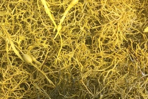
Kelps include a number of large brown seaweeds which store huge amounts of carbon and can form forests in the sea
along with other high canopy seaweeds which hold onto rocks, or boulders with their rootlike hold fasts. Search in the
lowest intertidal, the sea and in pools. The two main kelp species we are looking for here are:
Forest kelp or Cuvie, Laminaria hyperborea has a rough stipe where lots of other
seaweeds can settle It grows a new blade in spring, pushing the old one up until it looks
like it has 2 blades on top of each other. Finally the old top blade falls off around now -
hence its Irish name Múrach Bhealtaine. – see photo of a swept up Cuvie taken in
February, with the new amber coloured blade is starting to form. At low tide you might
see kelp forest in the water, with Cuvie stipes like bent over sticks ready to snap holding
the heavy blade.
Oarweed Laminaria digitata looks similar but has a more bendable stipe, oval in cross
                                             section, so smooth shiny that nothing can hold
                                             onto it. It can grow up from the seafloor rock,
                                             but also likes coming out sideways from walls
                                             and moorings as seen here.
                                             We would love you to take photos of kelp
                                             growing or swept up showing which species. Estimate or measure the length
                                             from holdfast to tip too, or put a biro or foot into the photo.

                                         Coral weed Cúnach Trá (Corallina )
                                         Is an unusual 3-6cm high calcium carbonate coated
                                         brittle little feathery red seaweed, which looks like a
                                         pink tuft when healthy, often with white tips. Look on
                                         rocks, under kelp where it might grow as an under
                                         story turf like ferns in the shade a forest. You might
                                         also find it as a band on edge of pools. Here it risks
                                         getting bleached and dying in hot summers. So if there
                                         is a rock pool where you see a good band of it, why
not photograph and monitor it as you go through the summer to record if it becomes white
bleached in a heat wave and dies. The second threat to this seaweed is ocean acidification, as
Coral weed may find it more and more difficult to extract calcium for that characteristic cover.
(see also mauve pink seaweed in photo below, with white tips.

One other very rare seaweed is a type of Eggwrack ( or Knotted wrack) which isn’t attached by a hold fast, but floats
like a yellow seaweed raft, with very few if any air bladders, or lies as yellow cushion or carpet on the shingle or mud
between rocks at low tide.
                                     This Ascophyllum nodosum var mackayi occurs only in extremely sheltered
                                     rocky shore inlets on the west coast and Strangford lough. With Brexit we will
                                     be the only EU country known to have this. It is protected as a priority species in
                                     the UK and Northern Ireland see
                                     http://www.habitas.org.uk/priority/species.asp?item=661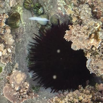
ANIMAL QUESTIONS

NOTE: When you move seaweed or turn a rock to find animals or their eggs, ALWAYS put them back, and do so gently.
A little wedge helps avoid squashing life.
                                                     The photo here includes a limpet, barnacle and keel worms.
                                                    Some dogwhelk eggs like yellow skittles are in photo beside
                                                                            it. Look for these in nice sheltered
                                                                            spots under rocks or away from waves.
                                                                            Our biodiversity poster from the
                                                                            autumn survey (also on line) has
                                                                            species photos to quickly check in the
                                                                            field

                                                                                Note - Limpets and Barnacles have the
                                                                                same Irish name but are totally
                                                                                different animals. The limpet is a
                                                                                vegetarian mollusc which moves
                                                                                around like your garden snail once the
      tide comes in to graze on the seaweed film on rocks. Barnacles are crustaceans like crabs which you see in photo
      above as tiny grey volcanoes with trap door tops. They cannot move once they are attached to rocks or other
      surfaces. They feed by opening trap doors at the top when the tide is in.

Some common queries about stings and warning:
▪ Dark brown shiny blobs stuck on rocks are likely to be sea anemone with tentacle
retracted waiting for the sea to cover them again so they can take tentacles out
and start feeding. You might see some in rock pools or under water. Those tentacles
sting but you would not feel it more than a tiniest tickle. The snake lock anemone
cant retract tentacles and If it’s really healthy the tentacles look green as it hosts
tiny algae which photosynthesise and provide extra food for the snakelock. The
tentacle tips might be pink then like painted fingernails. Without the algae, the
snakelock looks grey and sad.

Black with spines are sea urchins and those spines do hurt! The blobs are not eyes,
but something swimming on the water or on his spines.

Some jellyfish like the lion’s mane sting badly even when swept up and dead. See Coastwatch jellyfish poster on our
website.

If you find one dead or an oiled bird, look around to see if there are more. Can you identify it/them? Is a foot ringed? If
yes, please note down number and contact BirdWatch/RSPB. Or contact Coastwatch and we pass the information on.
Please note any dead or injured animals especially if any were entangled in nets or litter. Take photos and note location in s.u.

The Common Seal (Phoca vitulina) is pupling now, so be extra careful not to disturb any of these protected animals, More
information from https://www.npws.ie/marine/marine-species/common-seal or http://www.sealrescueireland.org in
Courtown or www.irishsealsanctuary.org in Dublin.

These extra questions are just picking up a tiny bit of our enormous shore biodiversity.
We focus here on 3 worms, 6 native seashells and 2 invasive molluscs. Select a mixed shore with bits of mud, sand,
boulders, or rock outcrop to maximise your chances of finding all. If you are in a rocky shore area and are in a group or
school class, you might do a whole shore project with transect or plan a shore treasure hunt including much more. Use
or adapt the Ulster Wildlife tick posters to do that. You learn a lot about your shore, it’s fun and you can share that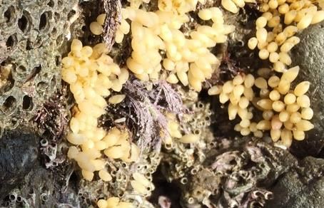
information with others. Your results may highlight special fragile life which needs to be taken into account next time
an activity is planned for this area.
WORMS:
 Lug worms live in U shaped burrows in muddy sand and mud flats.
 Their presence is given away by the little funnel where they take
 water in and the heap of squiggles at the other end. The larger the
 squiggle, the larger the worm. While the adults live lower down,
 look out for a nursery area dotted with tiny squiggles high on the
 shore.

 Honeycomb worms create s c reefs are only found in a few areas.
 In one survey, a Wexford county council surveyor found the longest
 known intertidal honeycomb reef in Ireland. With our ~7000 km of
 coast and very few scientists working on it, your information is
 really valuable.

 Sand masons live buried in the sandy mud sediment but their little
 tentacle tops stick out and look like tiny dead forests with whitish
 branches.

Find more information about Ireland’s biological diversity at http://maps.biodiversityireland.ie/#/Map
SEA SHELLS:
There are many species. See separate seashell posters to download or you might still have a hard copy from last year.
We are particularly interested in some and here is why:
Mussels as the number of beds has really gone down in recent years for a number of reasons with high summer
temperatures possibly adding to stress.
                                                          You might find tiny mussels as the babies which were
                                                          swimming around in the water column as plankton, have
                                                          settled out ( = spatfall) like a blanket which may grow into a
                                                          new mussel bed, or into an old bed between the adults or
                                                          hiding in cracks or even holding on to little low tide
                                                          seaweeds, like birds in a tree.

Please report Gigas Oysters stuck to rocks and Slipper limpets right away. INVASIVE ALIEN SPECIES:
FISH AND FISH EGG CASES: Many marine fish have juvenile stages which might be seen around this time of year in
coastal areas swimming or hiding under seaweed or stones like eels or butter fish. That is why apart frikm the general
fish present absent question, we ask you to lift 10 stones and check for fish. Make sure you put rocks back immediatelu.
Egg cases (mermaids purses) can be collected and kept for years. You might collect some to ID at home after soaking in
water.
MARITIME SPATIAL PLAN
Local knowledge of traditional rights, archaeology and even who harvests what and when on our shores is important
information and should be considered for inclusion in our first Maritime Spatial Plan (MSP) which is now being
finalised. The draft had special provision for high biodiversity valiue shore features to be marked. We also encourage
you to add any traditional rights or uses you know of.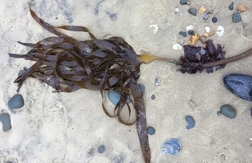
Data Return (back at home)

INPUT FORM
Input your results using our online input form.
NOTE
▪ You must complete 1 form per 500m survey unit (it should take 5 to 8 min. to input each form)
▪ If you are submitting data for several survey sites you don’t have to fill in your personal details every time, only the
first time (address, telephone, email), for the following submissions just give your full name.
▪ If you haven’t completed the mandatory fields (*) you will not be allowed to submit (survey codes, name, date..)
PICTURES AND VIDEOS
 We have the same photo upload opportunity you may have tried as a new feature last autumn. Following this link
you’ll be able to upload files directly from your computer, phone or tablet. http://coastwatch.org/europe/send-your-
pictures/

You can also email pictures, video clips or any other extra to survey@coastwatch.org

Categories of video or photo are particularly useful for our Coastwatch survey:
1. Categories :
    -   saltmarsh, peat bog, reedbed and sea grass carbon store wetlands, both a broad view and for seagrass really
        important a close up so we can identify.
    -   A riot of colour of coastal flowers.
    -   Any of the seaweed, or animal species we list in the survey, or signs they make marks they make or an amazing
        patchwork of species or habitats Catch these with photos or short video(s), upload and add any extra
        information. Purpose: 1. Celebrate the richness of our shores 2. Inform shore users to prevent damage.
    -
   Action needed: structural damage to a sea wall, dumping waste, or micro litter hot spot, a raw sewage discharge,
   oil pollution, a dump or infill, defunct materials in the intertidal, a spot where the sea has pooled litter… Your images
   assist planning the logistics of action with note in the last question on comments/concerns.
   You the Surveyors: One nice surveyor shot, with names would be great for exhibition and use in credits collage.
   Baseline: e.g. - stand on a vantage point and photograph down the splashzone and shore to low water. Then repeat
   in the opposite direction, standing at low water and taking a shot back to show the shore up as far as the vantage
   point or higher. A third may cover shore users and signs of use like tracks of humans and of wildlife. Future surveyors
   can repeat the exercise and view changes in land and shore use.
   ID: not sure what you found? Carefully video or photograph the animal, plant, feature or object and a marker to
   locate it again. Use for strange containers & ammunition.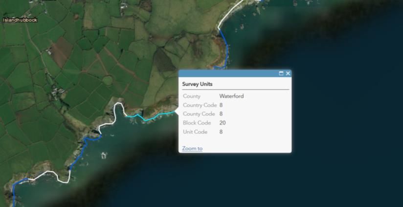

You can also read