Navajo Unit Operations Coordination Meeting - April 20, 2021 1:00 PM Microsoft Teams Virtual Meeting
←
→
Page content transcription
If your browser does not render page correctly, please read the page content below
Navajo Unit Operations
Coordination Meeting
April 20, 2021 1:00 PM
Microsoft Teams Virtual Meeting
Agenda
• Review of operations to date WY 2021
• Current basin status
• WY 2021 weather – Aldis Strautins, NWS
• WY 2021 flow forecast – Ashley Nielson, CBRFC
• Colorado Dust on Snow – Jeff Derry, CSAS
• WY 2021 proposed operations
• Comments and Reports
Reclamation Hydro Data
https://www.usbr.gov/uc/water/hydrodata/reservoir_data/site_map.html
Reclamation Teacup Diagrams
https://www.usbr.gov/uc/water/basin/index.html
https://waterwatch.usgs.gov/index.php?id=wwdur_cumflow
Weather Outlook
        April 2021

     Aldis Strautins
National Weather Service
    Grand Junction, CO
  http://www.weather.gov/gjt
Weather Outlook
                             April 2021

                         Discussion / Outline
• Since the first of the water year temperatures over southeastern
  Utah were cooler than normal and over southwestern Colorado
  warmer than normal. For Precipitation well below normal over
  the headwaters since the first of the water year.

• So far for the beginning of January colder than normal with
  precipitation well below normal for most locations except along
  the Utah and Colorado border north of the Four Corners.

• Storms in late February and March brought some brief relief to
  portions of the Four Corners Region but the first half of April has
  been very dry.
Weather Outlook
                           April 2021

                       Discussion / Outline
• Extreme to Exceptional drought remains entrenched over the
  head waters and Four Corners region.

• ENSO - Neutral conditions are present and are expected to
  continue this spring into summer and then transition toward a
  weak La Nina next fall.

• Spring into early summer higher chances of below normal
  precipitation. Higher chances of above normal temperatures

• Drought is predicted to remain.
The Past
April 2021
Water year 2020 Aug – Oct 2020
Precipitation - % of normalThe Past
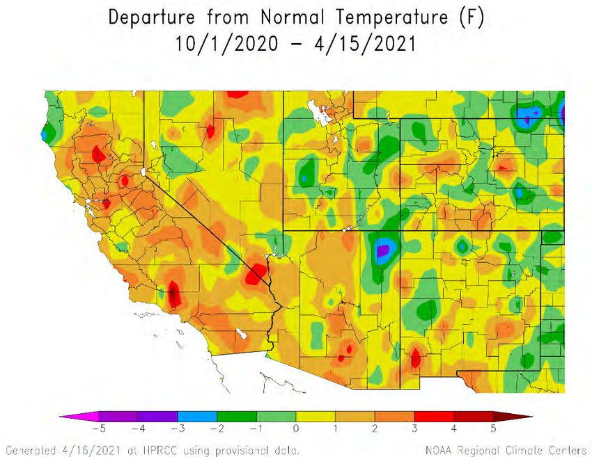
April 2021
Temperature Precipitation
Departure from normal % of normal
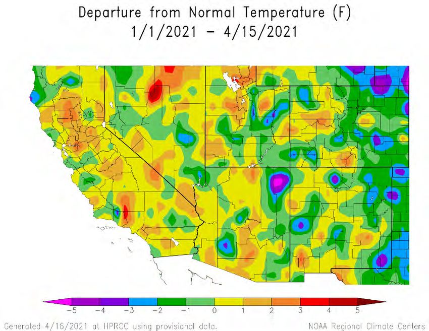
Water Year 2021The Past
April 2021
Temperature Precipitation
Departure from normal % of normal
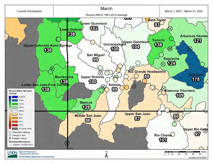
Since Jan 1, 2021Snotel
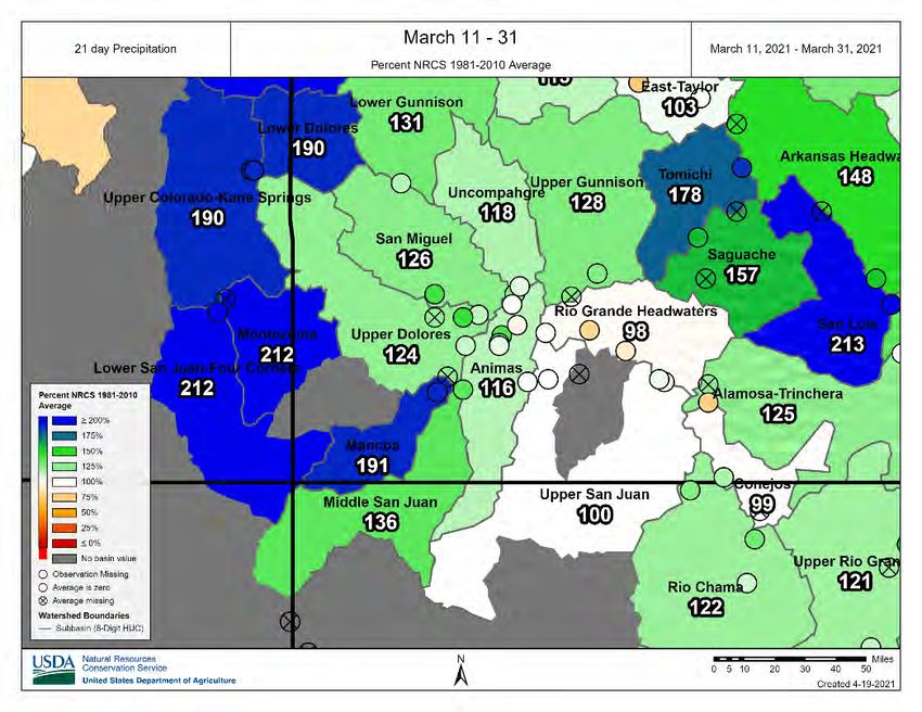
April 2021
March, 2021 March 11-31, 2021
SNOTEL - Precipitation
Percent of NormalThe Past
April 2021
Temperature Precipitation
Departure from normal % of normal
From April 1, 2021Snotel
April 2021
SWE Precipitation
SNOTEL - Percent of Normal - Colorado
Water Year 2021 (as of Apr 15)Snow
April 2021
SNOTEL Snow Water Equivalent – NRCS
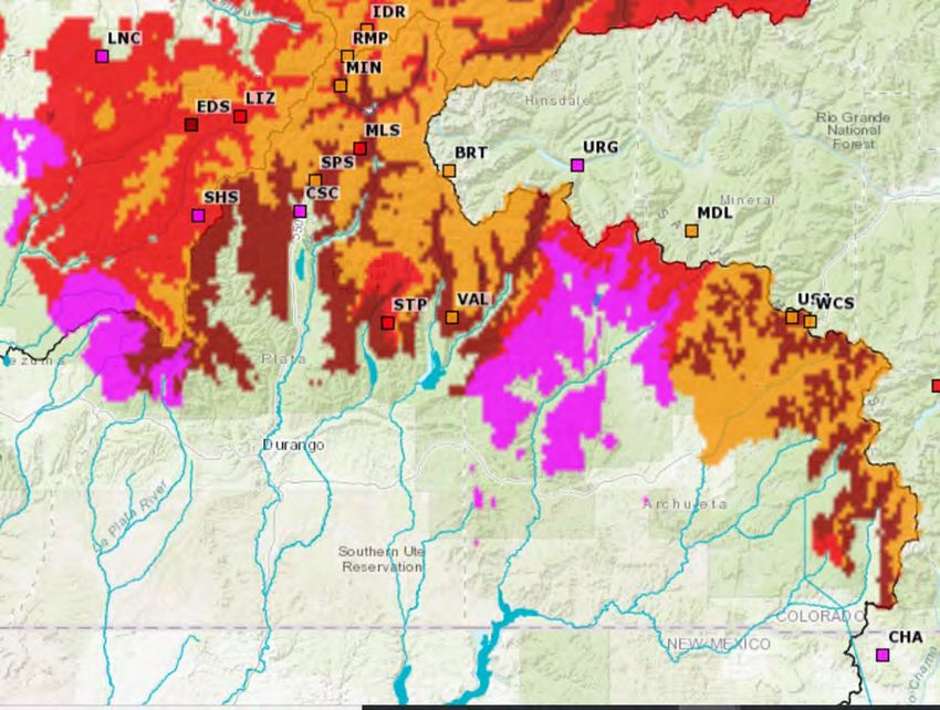
Southwestern ColoradoDrought
April 2021
April 13, 2021 April 14, 2020
Drought – MonitorENSO
April 2021
CPC/IRI Early-Month Consensus ENSO Forecast
Probabilities
(using NWS CPC classification system)
Season La Niña Neutral El Niño
MAM 2021 50% 50% 0%
AMJ 2021 21% 79% 0%
MJJ 2021 15% 81% 4%
JJA 2021 20% 68% 12%
JAS 2021 30% 57% 13%
ASO 2021 37% 50% 13%
SON 2021 41% 46% 13%
OND 2021 46% 41% 13%
NDJ 2022 47% 40% 13%
ENSO – Outlook
Neutral remaining through spring and summerWeather Outlook
April 2021
Temperature Precipitation
May – OutlookWeather Outlook
April 2021
Temperature Precipitation
May/Jun/Jul – OutlookWeather Outlook
April 2021
Temperature Precipitation
Jun/Jul/Aug – OutlookWeather Outlook
April 2021
Temperature Precipitation
Jul/Aug/Sep – OutlookWeather Outlook
April 2021
Seasonal
Drought– OutlookWeather Outlook
April 2021
Aldis Strautins
NWS Grand Junction, CO
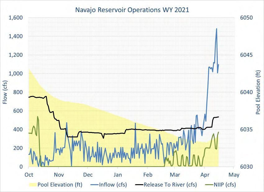
http://www.weather.gov/gjtNavajo Reservoir/San Juan Basin
Water Supply Outlook
April 20, 2021
Ashley Nielson
Senior Hydrologist
Colorado Basin River Forecast Center
National Weather Service/NOAAOutline ● Modeled Soil Moisture Conditions ● Snow Conditions ● April 2021 Water Supply Forecasts ● Forecast Uncertainty ● Summary ● Contact Information
Modeled Fall Soil Moisture Conditions

   April - October 2020 SNOTEL Precipitation Ranking             Fall 2020 Modeled Soil Moisture Conditions

                                       Fall 2020

   ●   Near to record low historical precipitation from April-    ●   Soil moisture conditions entering the winter were
       October of last year.                                          below normal and generally in the bottom 3 of the
   ●   SNOTELs have a 35-40 year period of record.                    1981-2020 40-year period.
   ●   Lack of monsoon and a below average 2020 spring runoff     ●   Conditions are similar to last year in the eastern
       exacerbated dry conditions.                                    headwaters but worse over the rest of the basin.
                                                                  ●   A portion of the snowmelt will be absorbed into the
                                                                      dry soils. The forecasts are accounting for this loss.
Snow Conditions: SNOTEL
SNOTELSnow
SnowWater
WaterEquivalent
Equivalent
April 20, 2021
2021 FCST: 185 KAF / 45%
1988: 296 KAF / 71%
2003: 242 KAF / 58%
2013: 178 KAF / 42%
Snowpack in the San Juan Basin is much below normal.
Snow did not reach the normal peak SWE and significant
early melt has occurred.
SWE vs. runoff is not a 1-to-1 relationship; spring weather
will play a role in the final outcome.Snow Conditions: CBRFC Model Snow Water Equivalent
April 19, 2021
Upper Model SWE Median (11,000’-13,000’+)
Upper 2021 Model SWE (11,000’-13,000’+)
Middle Model SWE Median (9,500’-11,000’)
Middle 2021 Model SWE (9,500’-11,000’)
*Only areas above 9000 ft that are significant to
runoff
● Modeled snow is below normal above 9500’
Model snow includes areas above and below SNOTEL sites.
● Significant melt has occurred below 11,000’; earlier than
● SNOTEL locations range from 8,500-11,500’
normal.
● Some modeled basins extend to over 13,000’
● Snow is still accumulating above 11,000’.
● Model indicates normal time of peak for SWE above 11,000’
is early May.April 1st Water Supply Forecasts: San Juan River Basin
April-July Forecasts
Volume in 1000’s acre-feet / Percent of 1981-2010 average
Animas-Durango
4/1: 210 / 51%
4/16: 185 / 45%
Rio Blanco-Pagosa
San Juan -Bluff 4/1: 41 / 76%
4/1: 505 / 46% Vallecito 4/16: 41 / 76%
4/1: 103 / 53%
4/16: 92 / 47%
Navajo Reservoir
4/1: 395 / 53%
4/16: 370 / 50%
Main forecast drivers:
• Dry antecedent soil moisture conditions
• Below normal snow conditions
● April 1st forecasts range from 35-75% normal with a median forecast of 50%.
● Forecast guidance has decreased by ~5-10% of average since the April 1st
forecasts.Forecast Progression: Navajo Reservoir Inflow
AVERAGE 10%
MEDIAN
10% chance volume will be greater
than 550 KAF/ 75% of average
50%
April 16 50% Forecast: 370 KAF / 50%
90% chance volume will be greater
90% Jan Feb Apr Mid-Apr than 270 KAF/ 37% of average
Fcst Fcst Mar Fcst Fcst
Fcst
Historical Minimum Observed: 52 KAF (provisional)
Blue shading: Daily Raw Model Guidance 90% - 10% exceedance range Navajo Reservoir Inflow Forecast Plot Link
Blue line: Daily Raw Model Guidance 50% exceedance
Pink line: Official forecast 90%, 70%, 50%, 30%, 10% exceedance San Juan River Forecast Plots Link
Green solid: 1981-2010 average April-July volume
Green dotted: 1981-2010 median April-July volume
Brown dotted: Average observed
Orange dashed: 2021 Observed StreamflowForecast Verification
Navajo Reservoir Inflow
April 1st Forecast 1991-2020
Over forecast
Historical Forecast Errors with similar April 1 Forecasts
APR 1 FCST OBSERVED
YEAR (KAF) (KAF) Error KAF / %
2003 400 307 93 / 30%: over
2006 395 379 16 / 4%: over
1999 375 755 380 / 50%:under
2013 370 267 103 / 38%: over
Under forecast
Mar 1st average error: 22%
Apr 1st average error: 18%
May 1st average error: 15%Summary
• Below normal water year precipitation in the San Juan River Basin
• Below normal snow conditions
• Early melt
• Near/record low antecedent soil moisture conditions entering water year 2021 snow accumulation & runoff season
• Two consecutive years of poor Monsoon
• Limited groundwater recharge since 2019 runoff
• April water supply forecasts (% of normal):
• April 1st forecasts range between 35-75% of average
• Forecast guidance has decreased by ~5-10% since the April 1st
• Best conditions are located in the eastern headwaters and deteriorate moving west towards the Animas River Basin.
• Dry soils will most likely impact runoff with a portion of the snowmelt being absorbed into the ground.
• Early runoff implications:
• Impacts depend on specific basin characteristics
• Could be less efficient early in the melt due to dry soils
• Could be more efficient due to faster melting snow pack
• Could cause increased evapotranspiration in the later portion of normal the runoff period as bare ground and soils dry out sooner;
ultimately leading to lower flows.Contact Info
Contact Information
• Operational Hydrologist: in office
• 801-524-4004
• cbrfc.operations@noaa.gov
• Ashley Nielson - San Juan River Forecaster
• ashley.nielson@noaa.gov
• 801-524-5130 x333
CBRFC Webpage
https://www.cbrfc.noaa.gov/
CBRFC Water Supply Presentations
https://www.cbrfc.noaa.gov/present/present.phpColorado Dust on Snow Program (CODOS) Wolf Creek Pass, Reported April 14th, 2021
Water Supply
 Forecasts
 (April-July)

CBRFC Water Supply Forecasts
https://www.cbrfc.noaa.gov/
                               As of Jan, 2021
Water Supply Forecasts (April-July) Navajo: 370 kaf (50% avg) Vallecito: 92 kaf (47% avg) Lemon: 22 kaf (40% avg) Animas: 185 kaf (45% avg) McPhee: 95 kaf (32% avg) Powell: 2,700 kaf (38% avg) As of April 15, 2021
San Juan River Recovery Implementation Program Modified Decision
            Tree (updated 2018)

PRELIMINARY AVAILABLE WATER CALCULATION FOR WY 2021
                   CBRFC Forecast Date:                            April 2021
                                                  Available Days                                Volume over    Sept 30 Pool
Current Forecast

                                                                                  Proposed
                                Available Water   at Peak (need       Proposed                   6063 ft on   Elevation (ft)
                     Forecast                                                      Release
                                over 6050 (kaf)    min of 21 for       Release                   Sept 30th    with proposed
                                                                                 Volume (kaf)
                                                       SPR)                                         (kaf)        release
                      MIN            -373               0               none          0              0            6013
                      MOST           -149               0               none          0              0            6036
                      MAX            -33                0               none          0              0            6052
What does it mean? Based on current storage levels and the ESP trace forecasts, • No spring peak release is planned • Releases through the summer will likely range from 600 cfs to 1,000 cfs. • Most probable forecast peak pool elevation is near 6043 ft (Min Prob 6038) • Most probable forecast Sept 30th pool elevation is near 6035 ft (Min Prob 6021) • Flows at Four Corners are unlikely to meet SJRIP Flow Targets under these forecasts. • No runs result in a shortage for WY 2021, however, 3% chance of shortage in WY 2022 (one run out of 35 results in a shortage).
Summary                              Next mtg August 24th – Virtual? In-Person?

• Extreme to Exceptional drought remains entrenched over the headwaters and Four Corners and is
  predicted to remain.
• Snowpack peak was below-average for the San Juans, and runoff has begun early.
• The April-July runoff most probable forecast for Navajo is 370kaf (50% of average). Other basins
  in the San Juans have similarly low forecasts.
• Antecedent soil moisture was record low entering this winter, which is another driver of below-
  average forecast runoff.
• Based on current conditions (snowpack and reservoirs), and the range of forecast possibilities
  provided by CBRFC, no spring peak release is planned
• Expect low releases throughout the runoff season (300-500 cfs) as minimum releases to meet the
  target baseflows will be made. Summer releases will likely be higher than normal, between 600
  and 1,000 cfs releases will be likely unless we have a wet summer.
• Currently no shortage is in the forecast for the San Juan River Basin in water years 2021-2022.
Reclamation Contacts:

Marc Miller – Water Management Group Chief
970-385-6541 mbmiller@usbr.gov

Susan Novak Behery – Hydrologic Engineer
970-385-6560    sbehery@usbr.gov

To be added to Navajo Dam notices email list, send an email to
westcoloareaoffice@usbr.gov

                                  Useful Links
                                  Reclamation: www.usbr.gov/uc
                                  USGS: water.usgs.gov/nwis
                                  CBRFC: cbrfc.noaa.gov
You can also read