New possibilities - Central West Regional Resilience Strategy Championing resilience and prosperity across Central West Queensland - Queensland ...
←
→
Page content transcription
If your browser does not render page correctly, please read the page content below
New possibilities

               Central West Regional
                  Resilience Strategy
                    Championing resilience and prosperity
                        across Central West Queensland

January 2020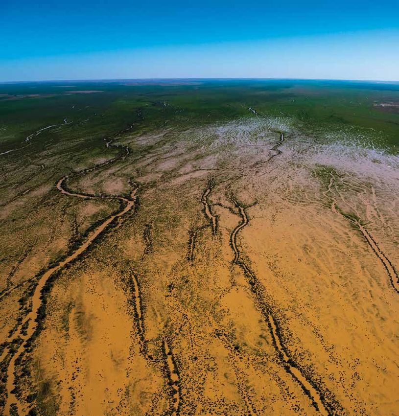
Document details                                                                                                Copyright
      Security classification                      Public                                                            This publication is protected by the Copyright Act 1968. © The State of
                                                                                                                     Queensland (Queensland Reconstruction Authority), January 2020.
      Date of review of security classification    January 2020
      Authority                                    Queensland Reconstruction Authority     Licence
      Document status                              Final                                   This work is licensed by State of Queensland (Queensland Reconstruction Authority) under a Creative
                                                                                           Commons Attribution (CC BY) 4.0 International licence.
      Version                                      1.0
      QRA Reference                                QRATF/19/3890                           To view a copy of this licence, visit www.creativecommons.org/licenses/by/4.0/
                                                                                           In essence, you are free to copy, communicate and adapt this publication, as long as you attribute the
                                                                                           work to the State of Queensland (Queensland Reconstruction Authority).
      The Central West Queensland Regional Resilience Strategy New Possibilities
      is a locally-led and multi-disciplinary approach to championing resilience and                      Interpreter
      prosperity across the Central West, and is a partnership between the organisations                  The Queensland Government is committed to providing accessible services to
      listed below.                                                                                       Queenslanders from all culturally and linguistically diverse backgrounds. If you have
      Remote Area Planning and Development          www.rapad.com.au                                      difficulty in understanding this report, you can access the Translating and Interpreting
                                                                                                          Services via www.qld.gov.au/languages or by phoning 13 14 50.
      Board (RAPAD)
      Barcaldine Regional Council                   www.barcaldinerc.qld.gov.au            Disclaimer
      Barcoo Shire Council                          www.barcoo.qld.gov.au                  While every care has been taken in preparing this publication, the State of Queensland accepts no
                                                                                           responsibility for decisions or actions taken as a result of any data, information, statement or advice,
      Blackall-Tambo Regional Council               www.btrc.qld.gov.au                    expressed or implied, contained within.
      Boulia Shire Council                          www.boulia.qld.gov.au                  To the best of our knowledge, the content was correct at the time of publishing.

      Diamantina Shire Council                      www.diamantina.qld.gov.au              Copies
      Longreach Regional Council                    www.longreach.qld.gov.au               Copies of this publication are available on our website at: www.qra.qld.gov.au/centralwest
      Winton Shire Council                          www.winton.qld.gov.au
                                                                                           Further copies are available upon request to:
      Queensland Government                         www.qld.gov.au                         Queensland Reconstruction Authority
                                                                                           PO Box 15428
                                                                                           City East QLD 4002
                                                                                           Phone (07) 3008 7200
                                                                                           info@qra.qld.gov.au
                                                                                           www.qra.qld.gov.au

           Acknowledgement of Country
           We acknowledge the Aboriginal peoples
           and Torres Strait Islander peoples as the
           Traditional Owners and Custodians of this
           Country. We recognise and honour their
           ancient cultures, and their connection
           to land, sea and community. We pay our
           respect to them, their cultures, and to their
           Elders, past, present and emerging.

2   Central West Regional Resilience Strategy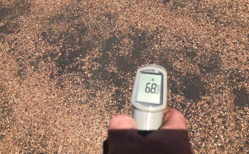
Foreword
The boom and bust cycle of flood and drought is endemic to                New Possibilities has been developed as a partnership between
Central West Queensland, but these cycles are changing.                   the Queensland Government, the Remote Area Planning and
                                                                          Development Board (RAPAD) and its member councils. Its purpose
As our landscape, weather and climate continues to change, our            is to guide how we work together to proactively support resilience
drive towards continuous improvement and sustainability for our           action across the Central West.
communities is being challenged. To meet this challenge, together
we must strategically navigate our ‘pathway to prosperity’.               The seven councils of the Central West together form RAPAD, a
                                                                          regional collaboration of councils with a key focus on delivering
These cycles are often reflected and expressed in economic, social        shared solutions to common challenges across the Central West.
and environmental terms, with cascading effects that can be far           Together, these councils include:
reaching and which impact upon the wellbeing of our region. The
communities of Central West Queensland are amongst Queensland’s             Barcaldine Regional Council
most resilient. However, identifying opportunities to bolster               Barcoo Shire Council
resilience action into the future can help our region to collectively
‘change the game’ in supporting individuals, communities, the               Blackall-Tambo Regional Council
economy and the environment to continue to prosper.                         Boulia Shire Council
New Possibilities draws upon an expansive evidence base to build a          Diamantina Shire Council
pathways approach to transition towards a climate resilient future for      Longreach Regional Council
our region. It identifies opportunities to strengthen community and
climate-related disaster resilience. Collectively, we know our regional     Winton Shire Council.
aspirations and what we want for our future. New Possibilities charts
a pathway to help us to move towards that vision. This Strategy is
supported by an Action Plan to guide our focus and priorities over
time, to match community need with possible funding pathways.
Its ultimate goal is to underpin a sustainable and prosperous             Councillor Rob Chandler
Central West into the future.                                             Chair of the Remote Area Planning and Development Board (RAPAD)

Image: Courtesy of Queensland Museum Network.
Photo by Gary Cranitch.                                                                                                                        3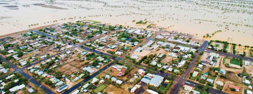
There is no other region in Australia quite like Central West Queensland.
    Steeped in rich Aboriginal and pioneering heritage.
    Part of one of the world's last unregulated dryland river systems.
    A landscape of contrasts between flood and drought, boom and bust.
    The land of Burke and Wills, home of the legend of the Min Min Light.
    Stretching west to the Simpson Desert, beyond the Black Stump.
    Where famed bush ballad 'Waltzing Matilda' was penned.
    Home to legend of brazen cattle rustler Harry 'Captain Starlight' Redford.
    The birthplace of Qantas.

4   Central West Regional Resilience Strategy
Contents
  Foreword3
  Our vision                                                       6
  Our community											                                           7
  About the Strategy                                               8
  Our region                                                       15
  Our catchments                                                   16
  Our Exposures                                                    21
  Drought in the Central West                                      21
  Flood in the Central West                                        23
  Fire in the Central West                                         24
  Heat and heatwaves                                               25
  Weed and pest infestation                                        26
  Rural and remote resilience                                      27
  Resilient transport                                              39
  Resilient economy                                                43
  Resilient environment                                            47
  Strategic pathways                                               50

Images: (Left) Courtesy of Queensland Museum Network.
Photo by Gary Cranitch. (Above) Courtesy of Barcoo Shire Council.

                                                                         5
Our vision
     We are among Queensland's most resilient communities.
     We harness the value of connection - with each other, with our land
     and across this great region we proudly call home. We would not want to be anywhere else.
     We work hard to look out for one another, we come together to achieve greatness in a variety of ways.
     We act in collective spirit – it is part of the grassroots values of our bush communities.
     We look for ways to introduce innovation and ingenuity into every aspect of our day-to-day workings.
     It is bred into us – even our newcomers and visitors. It is a legacy of our strong pioneering heritage.
     We triumph over adversity, and come to expect the unexpected.
     The only thing certain about life in the bush – is uncertainty, and we thrive on it.
     We are of the land - the land of drought, fire and flooding rains. Our history and our know-how show us the
     pathway forward. Our land is self-sustaining, and so are we.
     When people come to stay or visit, we enjoy sharing our knowledge to help others to understand our way
     of life and the resilience it breeds – it attracts people to this amazing part of Outback Australia.
     We seek new opportunities to adapt and to prosper. We take proactive action to harness the power of our
     people. Our strength lies in our commitment and dedication to our communities.
     We are a proud and passionate Central West Queensland.

     Image: Jundah Longreach Road.

6   Central West Regional Resilience Strategy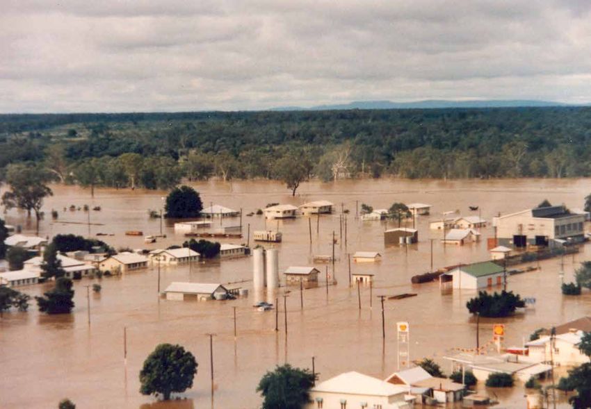
Our community
About our communities
The Central West region occupies almost 23 per cent of the area of       The region is a rich tapestry of landscapes and ecosystems, often in
Queensland, with a population of just over 10,500 people.                delicate balance within their boom and bust cycles. Rural settlement
                                                                         began in the 1860s with the discovery of the Mitchell Grass Downs
Key towns across the Central West include (from east to west)            and Channel Country by the early explorers.
Tambo and Blackall, Alpha, Jericho, Barcaldine, Aramac, Muttaburra,
Ilfracombe, Isisford, Yaraka, Longreach, Stonehenge, Jundah,             Since this time, agriculture continues to be the primary economic
Windorah, Winton, Boulia, Urandangie, Bedourie and Birdsville.           activity of the Central West, largely consisting of beef and sheep
Each and every town across the Central West maintains its own            production. This sector dominates the current employment share
unique character, steeped in rich history.                               of the Central West at 27.7 per cent. Tourism comprises 6 per cent
                                                                         of regional output (2017) and maintains an enormous capacity
Distance, isolation and remoteness characterises the Central West,       for growth. Towns across the region provide local services and
yet the sense of community is pervasive, fundamental and the life        industries which support our communities, our economy and
blood of the outback.                                                    local businesses.
Aboriginal peoples have lived in the region for at least 50,000 years,   Our love of the land, our neighbours, our work and our heritage
and the region is dotted with sites and artefacts which are testament    make opportunities like campdrafts, gymkhanas, racing events
to a long and enduring history on this land.                             and local social events the perfect occasion to come together as a
                                                                         community, and warmly welcome visitors from near and far to our
                                                                         special way of life in the Outback.

Image: Courtesy of Barcoo Shire Council.

                                                                                                                                                7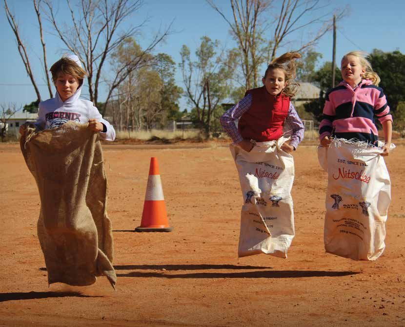
About the Strategy
     Purpose of New Possibilities
     Natural events in our region are not necessarily disasters, like they
     may be in the city. The natural processes of our landscape are part of
     our lifeblood, we respect and embrace it. However, we acknowledge           Our objectives under
     our climatic cycles are shifting. How we drive community and                New Possibilities are to:
     economic prosperity is intricately tied to our land and its function,
     and ultimately our overall resilience and ability to adapt to change        • thrive on uncertainty
     over time.
     The purpose of the Strategy is to:
                                                                                 • maintain strong settlements
     •     be a regional blueprint to guide coordinated                          • enhance liveability
           resilience action
                                                                                 • diversify economic activity
     •     guide how we work together to proactively journey toward
           enhanced community and climate-related disaster resilience            • adapt to climate uncertainty
           over time
                                                                                 • support local custodianship for
     •     combine strategy and investment in community resilience in a
           way that encompasses the impacts of our weather and                     environmental longevity
           climatic conditions
                                                                                 • support capacity and capability
     •     adopt a holistic approach to the factors that underpin and
           contribute to disaster resilience                                     • support connections.
     •     acknowledge the people of the Central West as being amongst
           Queensland's most resilient, and recognise the proud cultural
           and pioneering heritage of the region, and its important role as
           part of the Lake Eyre Basin
     •     forge a clear framework of strategies, building upon a
           comprehensive suite of existing studies and position
           statements derived at a local and regional level
     •     outline our approaches and actions to promote sustainable,
           resilient and prosperous Central West communities into the
           future, as well as the government systems that are critical to
           its success.

                                                                              Video: Find out more about the Central West Regional
                                                                              Resilience Strategy at www.qra.qld.gov.au/centralwest
                  New Possibilities recognises the
                   natural cycles of our landscape

     Image: Courtesy of Queensland Museum Network.
     Photo by Gary Cranitch.

8   Central West Regional Resilience Strategy
Championing resilience across
Central West Queensland
Championing resilience relies upon integrated and                  It is the intention of this Strategy that it is considered and
collaborative approaches.                                          factored into a range of cross-discipline strategies including
                                                                   (but not limited to):
Collaboration and integrated engagement has been critical to the
formulation of New Possibilities. This includes collaboration      •    regional plans
between governments, not-for-profit and non-government
organisations, community groups, landholders and industry          •    regional economic development strategies
representatives. It has involved a multi-disciplinary approach     •    regional transport and infrastructure plans
engaged in mental health, engineering, planning, community and
economic development, community recovery, agricultural and rural   •    natural resource management plans
industry, tourism, disaster management, land and environmental
                                                                   •    water resource plans
management, transport and communications.
                                                                   •    local and district disaster management plans
This multi-disciplinary approach has informed the adoption of
five elements which contribute to holistic resilience action:      •    local asset management and capital works plans
                                                                   •    local corporate and community development plans
                                                                   •    land use planning schemes
                                                                   •    local and regional health strategies.

                                                                              Resilience is multi-dimensional.
                                                                                   It is everyone’s business.

Image: Courtesy of Queensland Museum Network.
Photo by Gary Cranitch.

                                                                                                                                    9
Integrating related programs
      and projects
      New Possibilities combines and builds upon a range of local and                      Queensland Climate Adaptation Strategy
      regional strategic documents to articulate the various aspects of
                                                                                           The Queensland Climate Adaptation Strategy 2017-2030 outlines
      resilience action identified across the Central West. Some key plans,
                                                                                           how Queensland will collectively prepare for current and future
      projects and studies which have been drawn upon to inform this
                                                                                           impacts of a changing climate that reduces risk and increases
      Strategy include:
                                                                                           resilience. This Strategy recognises Queensland is already
      Resilient Queensland 2018-21 - delivering on the                                     experiencing hotter summers, more frequent natural disasters and
      Queensland Strategy for Disaster Resilience                                          impacts on our natural environment, and that these changes pose a
                                                                                           threat to our economy, our communities, our environment and our
      The Queensland Government is focused on strengthening disaster
                                                                                           way of life.
      resilience so that communities are better equipped to deal with the
      increasing prevalence of natural disasters.                                          The Strategy, along with specific sector-based adaptation plans,
                                                                                           outlines our commitments and the actions we will take to transition
      A key outcome of Resilient Queensland will be the development
                                                                                           to a low carbon, clean growth economy and adapt to the impacts of
      of regional resilience plans that will support the coordination and
                                                                                           a changing climate.
      prioritisation of future resilience building and mitigation projects
      across Queensland.                                                                   RAPAD Strategic Plan
      By 2022, every local government in Queensland will be part of a                      The RAPAD Strategic Plan 2018-2020 prioritises innovation, creativity,
      regional resilience strategy that clearly identifies and prioritises                 consultation and partnerships through the vision of 'a united
      actions to strengthen disaster resilience over time.                                 regional organisation, proactively shaping and creating a prosperous
                                                                                           future for the RAPAD region of Outback Queensland'. RAPAD has a
      New Possibilities is one of four regional resilience strategies being                regional mandate where decision-making, strategies and actions are
      piloted throughout 2019 as part of Resilient Queensland. It will be                  to produce an outcome that provides either multi-local government
      used to guide future regional resilience strategies being developed                  or regional benefit. Decision-making is to consider the cultural,
      throughout the state. The Strategy seeks to identify and address                     economic, environmental and social factors applicable to the region.
      locally-derived challenges which may also resonate more broadly
      with bush councils across western Queensland.                                        RAPAD Pathfinder Report 2017
                                                                                           The RAPAD Pathfinder Report 2017 is the result of a large project
      As the most disaster-impacted state in Australia, it is critical we
                                                                                           in partnership with the University of Southern Queensland and the
      harness best practice and look for new ways to work together to
                                                                                           Regional Australia Institute. The project was funded by the state
      improve the resilience of communities across Queensland, adopting
                                                                                           government and included a number of fact-finding and community
      pathways toward a safer, stronger and resilient Queensland.
                                                                                           engagement activities prior to releasing reports on the potential
                                                                                           future pathways for the central west. The pathfinder is a continuation
                                                                                           of the 2016 pathways research and community engagement.
     Queenslanders are disaster resilient when...
                             we work together                           we continually
                             to better manage                           improve how we
                             disaster risk                              prepare, respond
                                                                        and recover from
                                                                        disasters
                                                 we seek new
      we understand                              opportunities to
      our risk                                   reduce disaster risk

      Diagram: The four objectives of the Queensland Strategy for
      Disaster Resilience.

10   Central West Regional Resilience Strategy
Pathways to the Future Report 2017 Other state and local government and
The follow up report after the Pathfinder project is the Pathways industry documents
to the Future: Building Local Strategies for Regional Resilience A range of other state and local government plans, strategies
and Sustainable Development in Central Queensland 2017. This and studies have also been used to inform New Possibilities.
report highlights human capital as essential in building sustainable This is in addition to a series of industry-based documents and
development and that resilience is not an end, but a functional content prepared by relevant not-for-profit organisations and
means of a thriving regional system. To build resilience, there are non-government organisations with a presence in the
five crucial enabling factors in a region or community to be assured Central West.
and developed including awareness, diversity, integration, self-
regulation, and adaptation. The report identifies nine key themes
and seven resilience pathways, each of which has been factored into
the development of New Possibilities.
Beyond the Dust 2018
The Beyond the Dust 2018 report highlights the results from a study
which examined the impact of drought on small town business
across the Central West and reviewed the effectiveness of drought
assistance measures adopted between 2013-2016. The basis for
action to challenges across the region is driven by four key themes
including the decision to act, understanding the context,
supporting local capacities and local organisations, and
transformation for change.
11Walking the Landscape
New Possibilities is supplemented by a separate body of work led by The Walking the Landscape catchment stories can be accessed at
the Department of Environment and Science, called Walking www.wetlandinfo.des.qld.gov.au
the Landscape.
The preparation of New Possibilities and Walking the Landscape has
Walking the Landscape is a whole-of-system framework for been informed by a range of stakeholders from across the region,
understanding and mapping environmental processes and values and across Queensland.
across Queensland. It is a systematic and transparent science
synthesis framework which integrates existing data with local and A total of 11 'big map' workshops were conducted, involving local
expert knowledge through hands-on workshops to create a common residents, landholders and property managers, land managers,
understanding among multi-disciplinary teams. elected representatives, council staff and works officers, non-
government organisation representatives, community group
The framework incorporates all the available knowledge on representatives, industry bodies, state agency representatives and
landscape components (e.g. groundwater dependent ecosystems, emergency services personnel.
lacustrine wetland, vegetation etc.) and processes (hydrological,
geological etc.) and uses the information to produce conceptual In addition, extensive individual consultation, collaboration and
models which link to mapping. engagement with these valued stakeholders was also conducted
over a period of 18 months.
These products help answer questions such as how the landscape
contributes to flood behaviour or why groundwater dependent New Possibilities is a locally-led, regionally-coordinated and state-
ecosystems occur in certain locations. supported approach to championing resilience and prosperity
across the Central West.
The primary aim of the framework is to help develop a whole-of-
landscape understanding to improve evidence-based decision
making for the sustainable management and restoration of
ecological systems.
The Walking the Landscape engagement process was undertaken
in the Central West and map journals have been created for the
Queensland portion of the Lake Eyre Basin. The information
contained within these map journals links to New Possibilities,
helping to bare out the strong relationship between climatic
and weather systems, and their interaction with the landscape.
These relationships have obvious and direct cascading effects
on social and economic systems. As such, these map journals
help to chart the linkages between climate-related disaster and
overall community resilience with the deep understanding of and
connection to the landscape, which is inherent in residents across
the Central West.
Image: Courtesy of Queensland Museum Network.
Photo by Gary Cranitch.
12 Central West Regional Resilience StrategyQueensland portion of the
Lake Eyre Basin
The Central West area takes in seven local governments and The Lake Eyre Basin is a unique and special environment, home to
six sub-basins of the wider Cooper, Diamantina and Georgina a range of endangered and threatened animal and plant species,
catchments flowing into the Queensland portion of the Lake Eyre including rare migratory species. The habitat provided across the
Drainage Division. This area accounts for about 30 per cent of the Basin remains amongst Australia's greatest environmental assets.
Queensland’s land mass, including the area of the lower Cooper Every few decades, in good years, Kati Thanda-Lake Eyre in South
Creek Catchment within Quilpie Shire. The major systems of Cooper Australia will fill from floodwaters conveyed across a distance of
Creek, the Diamantina and the Georgina River catchments are almost 1000 kilometres.
extremely variable in their flow, either generating years of flourishing
flora and fauna or giving rise to years of drought. “The Lake Eyre Basin is one of the world’s last
unregulated dryland river systems”
Each of these catchments flow south from their respective
headwaters north of Boulia, Winton, Barcaldine and Blackall. The Desert Channels Queensland
river systems are characterised by very low gradients with wide,
For more information visit the Bureau of Meteorology article on
braided channels which do not always contain water. Each system
Queensland floods: the water journey to Kati Thanda-Lake Eyre at
drains into Kati Thanda-Lake Eyre in South Australia. Kati Thanda-
Lake Eyre is approximately 15 metres below sea level, Australia's http://media.bom.gov.au/social/blog/2059/queensland-
lowest natural point. floods-the-water-journey-to-kati-thanda-lake-eyre/
The desert uplands through the Barcaldine and Blackall regions are
also key groundwater recharge areas for the Great Artesian Basin
– the largest and deepest artesian basin in the world, underlying Aboriginal Way
over 20 per cent of Australian continent. The Great Artesian Basin is The Lake Eyre Basin Community Advisory Committee, over a period
considered one of the region's greatest assets, and supports life and of 12 years, has worked with Traditional Owners of the Lake Eyre
livelihoods across the Central West. Basin to prepare the Aboriginal Way Map. This map, now managed
by the Australian Institute of Aboriginal and Torres Strait Islander
Studies, features songlines, historical trade routes and other cultural
information about the basin, which covers 71 language groups. It
is an invaluable education resource on the richness, diversity and
vibrancy of Aboriginal cultures across the Lake Eyre Basin.
https://aiatsis.gov.au/explore/articles/lake-eyre-basin-
aboriginal-way-map
Image: Floodwaters near Birdsville making their way to Kati Thanda-
Lake Eyre in February 2019. Courtesy of ABC and supplied by C. Ellis.
13Central West Queensland
Remote Area Planning and Development Board (RAPAD) area
14 Central West Regional Resilience StrategyOur region
The Central West is a diverse community and this is reflected across
our major towns and centres of business.
Blackall-Tambo Winton
The Blackall-Tambo region comprises the key towns of Tambo Winton Shire includes the key towns of Winton, Middleton,
and Blackall. Tambo is the oldest town in the Central West and Corfield and Opalton and forms part of Australia's dinosaur trail,
also occupies the headwaters of five river systems including the and is home to the Australian Age of Dinosaurs and Lark Quarry
Burdekin, Bulloo, Fitzroy, the Murray-Darling and Lake Eyre. Blackall experiences, established following the discovery of dinosaur fossils
is a key administrative centre with a strong arts and cultural scene, and 'stampede' footprints immortalised in sedimentary rock –
and hosts one of the largest saleyards in the region - one of only two known as the 'Winton Formation'. Winton is also the 'birthplace' of
organic saleyards in remote Australia. Everything west of Blackall is Australia's most famous bush ballad 'Waltzing Matilda', penned by
beyond the Black Stump. Banjo Paterson during a visit to Dagworth Station in 1895, and first
performed at the North Gregory Hotel. Winton celebrates this history
Barcaldine with the Waltzing Matilda Centre, along with other events such as
the Outback Festival, Way Out West Fest and outback film festival,
The Barcaldine local government area is known for cattle, sheep Vision Splendid.
and wool production. It includes the townships of Alpha, Aramac,
Barcaldine, Jericho and Muttaburra. The Barcaldine region is
located at the headwaters of the Cooper Creek catchment, and is an Boulia
important groundwater recharge area of the Great Artesian Basin. Boulia is located on the banks of the Burke River. The township
The region is home to the world's largest sculpture trail and the name comes from the traditional Pitta Pitta language meaning
famous Tree of Knowledge, being the birthplace of the Australian ‘waterhole’. It is the land of the mysterious and legendary Min Min
Labor movement. Barcaldine's iconic windmill on Oak Street warmly Light. Situated only 200 kilometres from the Northern Territory
welcomes you to town, standing proudly upon the location of the border, Boulia is one of Queensland's western-most towns along
first flowing artesian bore in Queensland. with Urandangie, established in 1885 on the Georgina stock route
– once a popular place for drovers to pull up for a rest. The Boulia
Longreach Desert Sands Camel Races are an annual tourism favourite. The
Region is Queensland's gateway to the Outback Way which stretches
Longreach serves as one of the primary administrative centres in the from Winton to Laverton in Western Australia.
Central West. It is home to the Australian Stockman's Hall of Fame,
Qantas Outback Founders Museum along with a diverse range of
pioneering experiences. Longreach is home to the first cattle station Diamantina
in Queensland, Bowen Downs, as well as the legendary tale of cattle Named after the Diamantina River (which was named after Lady
rustler Harry 'Captain Starlight' Redford. Popular attractions across Diamantina Bowen – the wife of Queensland's first Governor),
the broader Longreach region include Ilfracombe's Machinery Mile, Diamantina Shire is home to three of Queensland's most remote
Isisford's Outer Barcoo Interpretation Centre Museum, and Yaraka's townships including Birdsville, Bedourie and Betoota. In the dry
Mt Slocombe Lookout. season, the 300+ population of the Shire swells by the thousands
as people flock to the area for the Big Red Bash and Birdsville
Barcoo Races. Diamantina Shire is home to just 14 stations, despite being
one of Queensland's largest local government areas by land size.
The Barcoo River and Thomson River meet to form Cooper Creek Its administrative centre is located at Bedourie, which is the local
south of the town of Jundah, and flows through to Windorah. Jundah Aboriginal word for 'dust storm'.
is the administration centre for the Barcoo Shire, whilst Windorah
was established on a stock route and remains a top fishing spot,
and is an ideal place for bird watching, as migratory species flock
to the region's waterholes after rain or flood. The township of
Stonehenge is located between Jundah and Longreach, and is
Queensland's home of bronco branding. 90 kilometres east of
Jundah lies the remnants of Magee's Shanty, immortalised in the
famed poem 'A Bush Christening' by Banjo Paterson.
Image: Sunrise, Diamantina River, Birdsville.
15Our catchments
Cooper Creek Catchment History and heritage
The Cooper Creek Catchment comprises the Thomson River, Barcoo The Cooper is rich in history. Indigenous history in the region dates
River and Cooper Creek sub-catchments. back more than 50,000 years with over 25 tribal groups living across
the Channel Country. Artefacts continue to be uncovered, and
The Cooper is the only watercourse in Australia where river systems Traditional Owner Dreamtime stories share the formative history of
(the Thomson and the Barcoo) run into a creek. the Cooper, as well as that of the Lake Eyre Basin region
more broadly.
The Thomson River is punctuated by billabongs, draining into
Cooper Creek from seven local government areas as far north as Cooper Creek was named in 1845 by Charles Sturt after Sir Charles
Charters Towers. It collects water from across central Queensland’s Cooper, the Chief Justice of South Australia.
many creeks before becoming the Thomson at Muttaburra. It
continues through Longreach and Jundah before joining the Barcoo Explored by Burke and Wills, Leichardt, Mitchell, Kennedy,
River north of Windorah. Landsborough and Buchanan, the Cooper Creek catchment forms
part of Western Queensland's semi-arid Mitchell grass country. It
The Barcoo River adjoins the Thomson River sub-catchment to the was on the Cooper that famed Australian explorers Burke and Wills
south. Major towns on the Barcoo River system include Barcaldine died in 1861, near Innamincka in South Australia.
and Blackall, with the small town of Jericho at the highest reaches of
its headwaters which lies on a low floodplain just 30 kilometres west In the 1880s, the town of Longreach was first surveyed, before
of the Great Divide. The large catchment area of the Cooper includes being gazetted in 1887. It is referenced that a local Indigenous group
land within the local government areas of Barcaldine, Barcoo, provided the survey team with information of the Thomson River in
Blackall-Tambo, Longreach and a small part of Quilpie Shire. flood which informed the location of the Longreach township. This
detail is included in historical publications, including that of 'The
Where the Barcoo meets the Thomson lies the beginnings of Longreach Story' authored by the late Angela Moffat.
true Channel Country.
Since before the establishment of the first station in the region,
The principal town is Windorah, perched at the edge of the sprawling Bowen Downs, the boom and bust cycles of flood and drought have
tributaries of the Cooper Creek where the abundant tributaries of the been front of mind – with commentary on such matters captured in
Thomson and the Barcoo join to form a riverbed some 10km wide in the journals and writings of the first explorers to navigate
true channel country form. The catchment spreads across the Barcoo the Cooper.
Shire to parts of Quilpie Shire and Bulloo, and across the border to
South Australia.
Image: Courtesy of Barcoo Shire Council.
16 Central West Regional Resilience StrategyDiamantina Catchment History and heritage
The Diamantina River rises in the Swords Range, some 70 kilometres The Diamantina River was named after Lady Diamantina Roma
south-west of Kynuna and flows initially in a north and easterly Bowen, the wife of the first Governor of Queensland, Sir George
direction before changing to a south-westerly direction Bowen. Lady Bowen was born in Greece and married Sir George in
70 kilometres west of Winton. Corfu in 1856. The Bowens arrived in Brisbane in 1859. The river was
named by William Landsborough in 1866. Landsborough was an
Major tributaries joining the river are Mills Creek, Nesbitt Creek, experienced bushman and explorer, chosen by the government to
Oondooroo Creek and Jessamine Creek, east of Winton as well as lead the search expedition for Burke and Wills in 1861. He was the
Wokingham Creek and the Western and Mayne Rivers north first man to cross the continent from north to south.
of Diamantina Lakes, and Farrars Creek south of Monkira.
Dagworth Station, located on the upper headwaters, is the
The Diamantina sprawls out into true Channel Country south of location of events which gave rise to Australia’s unofficial national
Diamantina Lakes. anthem, Waltzing Matilda, penned by A.B. ‘Banjo’ Patterson at
Combo Waterhole on the river in 1895. The river has been further
The river does not have a well-defined main channel but consists immortalized by ‘The Diamantina Drover’, written by Hugh McDonald
generally of a series of wide, relatively shallow channels. South of of Redgum in the 1980s.
Winton, the principal town on the Diamantina is the remote outpost
of Birdsville, and it receives waters from ten local government areas. Diamantina Lakes station was first established in 1875 before
Such is the scale of the Diamantina River catchment. From Birdsville, being purchased as a national park in 1992. Stations were taken
the Diamantina crosses the border into South Australia and flows up from the late 1860s especially after the publication in 1862
into Kati Thanda-Lake Eyre – the lowest natural point in Australia. of Landsborough's journals. The establishment of service towns
followed in the 1880s.
The first meeting of the Divisional Board of Diamantina was held
on 29 April 1886 and Birdsville was proclaimed as a town in 1887.
Until then it was known as Diamantina Crossing. Birdsville is
simply a reflection of the abundant birdlife in the waterholes of the
Diamantina River.
Images: (Left) Diamantina Causeway, (right) 1890 floods near Winton.
Courtesy of State Library of Queensland.
17Georgina Catchment History and heritage
The Georgina River catchment takes in a vast expanse of the state's Originally named the Herbert River by Landsborough, it was
border and extensive areas of the Northern Territory. renamed the Georgina in 1890 to avoid confusion with the
Herbert River in north Queensland. Apparently it is named after
It rises to the north-west of Mount Isa with three main tributaries the Queensland Governor’s daughter, Georgina Mildred Kennedy.
– the Buckle, Sander and Ranken Rivers. The latter two have their However, another theory is the name was changed to match the
headwaters in the Northern Territory. Diamantina and honour Sir George Bowen by the government
surveyor who thought this logical given the watercourses
Further inflow occurs from numerous creeks and rivers, the main eventually joined.
tributaries being the Burke and Hamilton Rivers which find their
headwaters in the Selwyn Range and flow south. It is home to Boulia The catchment extends north of Urandangi and Camooweal and
and Camooweal in the far north. into the Northern Territory, in the region of Lake Nash. This route was
used for stock transportation and townships sprung up as supply
The Burke joins the Georgina to the north of Marion Downs, whilst centres from the 1880s.
the Hamilton joins it to the south. At Marion Downs, the Georgina
spreads into braided channels – expanding across vast floodplains Urandangi itself was founded in 1885 when a general store was
on its travels to Bedourie. established along the Georgina stock route. By the 1920s it had
grown to include two stores, a hotel, dance hall, post office, police
It is at this point where the Channel Country meets the station and several houses. Its current resident population is
Simpson Desert. about 14.
The Georgina River catchment stretches across four Queensland As the Georgina flows south toward the South Australian border the
local governments including Cloncurry, Mount Isa, Boulia and floodplain enters the sand dunes of the eastern edge of the Simpson
Diamantina, not to mention areas of the Northern Territory. Desert. Local knowledge describes instances where waters travelling
down the Georgina 'disappear', seeping into cracking alluvial clays
and sand, and in some cases re-emerging downstream. Very few
stations flank the Georgina, making it one of the most remote parts
of Queensland.
Image: Eyre Creek Bedourie.
18 Central West Regional Resilience StrategyBurdekin Headwaters
East of Jericho lies the headwaters of the Belyando River. Flowing
north from Mt Observation, Mt Paddy, Mt Mudge and Mt Victor
are Duck Creek, Alpha Creek, Native Companion Creek and their
tributaries, as well as the Belyando River.
These waterways, including associated tributaries, flow north
through Alpha and across the Capricorn Highway. The creeks named
above eventually each flow into the Belyando River to the north of
the Barcaldine region, which in turn flows into the Suttor River at
Mt Douglas and onto Lake Dalrymple (Burdekin Falls Dam).
The area of the Barcaldine region which sits at the headwaters of
the Burdekin catchment continues to remain part of this resilience
strategy, along with the balance of the Barcaldine local government
area, however it will also form part of a flood specific resilience
strategy for the Burdekin and Haughton Catchment.
Images: Courtesy of Barcaldine Regional Council.
Source: Barcaldine Regional Council
19Boom and Bust
We are of a land that is born
of drought, fire and flooding rain,
and everything in between.
Image: A windmill at dusk.
Courtesy of Boulia Shire Council.
20 Central West Regional Resilience StrategyOur Exposures
Drought in the Central West
Australia is the land of drought and flooding rains. The severity and Drought affected areas can also be subject to flooding due to heavy
circumstances of drought depend very much on the local situation rains in river catchments hundreds of kilometres away without
in terms of climate and water use, which varies significantly across actually having any rainfall. These floodwaters can take weeks,
landscapes and land uses. and sometimes months to travel downstream, and in western
Queensland this is called a ‘dry flood’. However, one flood does not
Drought can be: break a drought. Especially if it does not break out of the banks,
• meteorological: dryness resulting from deficiencies a ‘gutter flood’, to spread across our vast channels.
of precipitation From 1895 to 1903 the whole of Australia was drought affected,
• agricultural: depletion of soil moisture supplies, or including central Australia. This was Australia's worst drought to date
• hydrological: shortfalls on surface and subsurface in terms of severity and area. Sheep numbers, which had reached
water supply. more than 100 million, were reduced by approximately half and
cattle numbers by more than 40 per cent. Dubbed the Federation
Drought sets in over several years, resulting in a persistent strain
Drought, the event was repeated a century later as the
on every day operations and ways of life as it wears on. Just as slow
Millennium Drought.
as the prolonged drought conditions set in, the recovery process
is equally as long. It can be easy for people to say that we must Halfway through the 20th century drought was again widespread
prepare for drought, but it must be acknowledged how challenging and severe. For more than a decade from 1957, drought was
this can be when drought conditions last for a decade or more. consistently prominent and frequently made news headlines from
The strain of drought will arise for us into the future as sure as day 1964 onwards. This period was tough in the Central West.
turns into night, and we will endure. By not only by being prepared,
From late 1996 to mid-2010, much of southern Australia (except
but because of the strategic and holistic approach we take to our
parts of central western Australia) experienced a prolonged period of
region's resilience.
dry conditions, known as the Millennium Drought, unique in
"You cannot 'drought-proof' yourself - being both widespread and protracted.
you can only manage it" Since 2011, much of the Central West has endured drought
Rick Britton, Goodwood Station and Mayor of Boulia Shire conditions with good floods becoming fewer and farther between.
Over recent years, prolonged drought conditions have given rise to
In the landscape of the Central West, drought is intrinsically related other, cascading issues from a social, economic and environmental
to climatic zones, the resistance of plants to water shortages and perspective. Rain and flood events in 2019 provided some relief in
the ability of the land to support the economy. Generally, natural some areas, however – not without a toll. Long-term drought effects
pastures and herbage have evolved to become highly resistant to coupled with driving rain, wind, cold temperatures and flooding led
extended periods of low rainfall particularly in the arid zone. to considerable stock loss north of Winton, largely as a result
of exposure.
The Central West and the Lake Eyre Basin in particular are unique
and self-sustaining landscapes. Soils, vegetation and fauna species One flood or rain event does not break a drought, and there are
have adapted to the natural extremes of boom and bust cycles, different types of drought.
springing to life when rain and floods occur.
The North and Far North Queensland Monsoon Trough, 25 January
- 14 February 2019, led to dry flooding in the lower parts of the
Diamantina catchment. This phenomenon clearly illustrates why a
single rain event does not break a drought.
Follow-up rain is essential.
Image: Courtesy of Queensland Museum Network.
Photo by Gary Cranitch.
21The frequency of dust storms also go hand-in-hand with drought,
when westerly winds from the continental interior blow across the
landscape, and they can be scary. Visibility decreases, homesteads
and buildings can be damaged and some people and animals
can experience severe respiratory distress as a result of the level
of particulate (fine dust) matter in the air. Dust storms do not just
occur during periods of drought, however. They remain a natural
phenomenon which kick up on occasion, given certain
atmospheric conditions.
Dust storms are not unusual to this part of the world and for the
most part they are a nuisance, but sometimes they can produce
circumstances which can present serious issues.
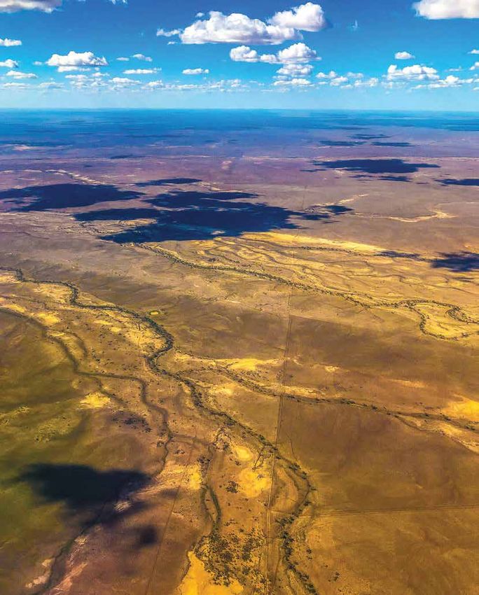
22 Central West Regional Resilience StrategyFlood in the Central West
Very little rainfall is needed to bring this country to a standstill. From an environmental perspective, both terrestrial and marine
This has a lot to do with the very slight gradient of the landscape ecosystems prosper with water. Whilst species in the Central West
and its underlying geology. These aspects apply to large areas of have adapted to periodic, severe dry conditions and survived
the Central West and work to limit absorption and enable the vast over millennia, ecosystem health is driven by species diversity.
spread of floodplains across the landscape. This is typical of vast Species diversity is bolstered by flooding, as biota is transported
swathes of this country which sit atop the Winton Formation. between waterholes, when they occasionally fill and connect across
the broader floodplain, or as terrestrial species find improved
The Walking the Landscape catchment stories for the Cooper, nourishment from a greater abundance of plants, insects and
Diamantina and Georgina provide further detail in relation to animals generated by flood events. The Lake Eyre Basin, every few
why and how floodwaters transition across the landscape. years, becomes a haven for migratory bird species, following rain
In the Central West, the river systems include the broad expanse and flood events.
of floodplains – not just river channels. In some locations, the With the good comes the bad and in some events, floodwaters have
floodplain extent can reach more than 70 kilometres in width. damaged town infrastructure and houses. In others, it has led to
These characteristics of topography, geology and flood behaviour tragic stock losses, in combination with other weather conditions. So
means it takes weeks, and often months, for floodwater to make whilst we recognise the role and the value of flooding, we are also
its way downstream toward Kati Thanda-Lake Eyre. There is simply well aware that it can cause damage, loss and isolation.
nowhere for rainfall from large, intense rain events to drain, other Isolation during a big wet is commonplace in the Central West.
than to travel south to Kati Thanda-Lake Eyre. Rain that falls near For those living on stations this can mean being prepared for long
Corfield or Kynuna, 164 kilometres north-west of Winton, can take up periods without re-stocking. The people of the Central West are
to three months to reach Kati Thanda-Lake Eyre due to the very low resilient and skilled at being prepared. However, we cannot ignore
gradient of the Diamantina River catchment. the fact that isolation can be a stressful experience for some people,
The Lake Eyre Basin gradient is often described as so slight that the whether in town or on a station. This can particularly be the case for
fall is the equivalent of less than 20 millimetres over the distance of the vulnerable, elderly and ill, those with disabilities, and visitors to
a football field. the region who are unfamiliar with driving to our unique conditions.
Floodwaters often reduce in volume on the journey down the Erosion and topsoil scour can be a significant effect of flooding,
floodplain, either absorbed into cracked clays and soils, or alluvium, and has many flow-on implications for businesses, rangelands
absorbed into groundwater aquifers, or through evaporation. health, infrastructure and service provision. Generally, it can be
worse during and following harsh drought conditions if herbage
In other parts of Queensland, flooding can be dangerous and cover has reduced over time, leaving valuable topsoil exposed to
destructive, but for western Queensland flooding presents different potential erosion and scour. Certain land management practices can
challenges. Agricultural impacts like stock loss can sometimes be employed which may mitigate topsoil transportation, scour and
arise, but for the most part flooding is good for the land, and erosion as the landscape transitions between its boom and bust
we welcome it as a necessity. Our ecological and environmental cycles of flood and drought.
systems come alive with water, and these are systems upon which
our region thrives. It rejuvenates the landscape, returning nutrients
to the soils, producing fodder, supporting native vegetation growth
and recharging groundwater. Flooding supports the health of our
landscape, which in turn supports our economy and
our communities.
Images: (Top) Flooding at Winton, March 2018.
(Top left) Diamantina Shire (bottom left) dust storm
at Bedourie. Courtesy of Leon Love, Diamantina Shire Council.
23Fire in the Central West
Fire is commonplace across the Central West, where large expanses
of the landscape comprise geologies which contain iron – a great
conductor of lightning. This is particularly evident across the desert Fire is endemic to
uplands area through Barcaldine and Blackall-Tambo, which is the Australian landscape.
slightly higher in its topography.
In this landscape, fire is a natural partner of drought. Forest and
scrub fires are certainly part of the Australian landscape, however Harnessing fire as a tool to manage the landscape for health and
fast-moving grassfires are equally as common. In an arid and semi- for risk management purposes is a core element of caring for
arid landscape comprising expansive Mitchell grass downs, swift Country. Since European settlement, the injection of fire into the
moving grassfires can grow rapidly and consume valuable stock landscape has decreased from which Traditional Owners applied
feed, damage or destroy facilities, buildings and infrastructure and which has led to changes in fuel load and ecological dynamics
potentially injure stock or lead to stock loss. They can also cause across different vegetation classes. Less frequent burning generally
irreparable damage to our unique Central West ecosystems. tends to generate hotter, more intense fire behaviour, as fuels have
built up over a longer period. This can lead to ecosystem damage
As equally a partner to drought, fire is also a partner of flood. Flood
as specimens could be harmed and become unable to regerminate.
events which trigger fodder growth through winter months equally
More frequent, cooler burns provide many ecological and risk
elevate fire threat in spring and into summer, with increased fuel
management benefits however, this must be balanced. Time-since-
loads spread across the landscape. Fodder is a prized resource, and
fire is a critical element in maintaining healthy flora and fauna, and
protecting it from grassfire is essential.
burning too often can also result in negative impacts.
How fire is used is therefore of great importance. The injection of
The Department of Environment and Science has prepared a range
good fire management practices into the landscape is critical for
of bioregional planned burn guidelines which are bespoke to each
bush and grassfire management, overall ecosystem health, as well
of the thirteen different bioregions of Queensland. Relevant to the
as for strategic fire management. Different vegetation communities
Central West region is the Channel Country Bioregion, the Mitchell
require different fire regimes. A fire regime articulates the threshold
Grass Downs Bioregion, the Desert Uplands Bioregion and small
for how frequently a certain vegetation community can experience
parts of the Mulga Lands Bioregion. Each of these bioregions
fire, before the ecological characteristics of that community start to
comprise different vegetation characteristics which in turn, attract
change – which is not desirable. A fire regime which is suitable for
vastly different fire regimes. Burning to Country, and cultural
spinifex grasslands for example, is not the same as that required to
burning, is critical to overall ecosystem health and is never a
appropriately manage acacia shrublands.
one-size-fits-all approach.
Image: Courtesy of the Department of Environment and Science.
24 Central West Regional Resilience StrategyHeat and heatwaves
Summer in the Central West can see temperatures creep towards 45 The Queensland Fire and Emergency Services (QFES) Queensland
degrees Celcius at times. Heat during these periods is constant and State Heatwave Risk Assessment was released in 2019, and
unrelenting, and whilst heatwaves compound this, from the local combines scientific data across hazard and risk, health and
perspective a few more degrees when the temperature is already environmental science. Human health and the well-being of animals
above 40 is not uncommon. How residents in different areas of and plants remain the core direct impacts, along with direct impacts
Australia feel heatwaves is different, because people may or may not to community infrastructure. This can be in the form of mechanical
be used to localised temperature ranges. Out-of-season heatwaves failure, failure or damage to essential services such as electricity and
are perhaps more of a challenge in the Central West. water supply, and interruption to transport.
There is a link between cyclones and heatwaves, and heatwaves Into the future and as our climate changes, the frequency and
and bushfire. intensity of heatwave conditions is likely to rise, and for this we must
plan and prepare at an individual, household and business level,
From a health perspective, heatwaves cause more deaths than as well as at the community level, in conjunction with emergency
bushfires, cyclones, earthquakes, floods and severe storms services, health services and government service providers.
combined. Heat exhaustion and heat stroke are the main health
illnesses connected with heat and heatwaves, relating to a person's Heatwaves are only one of a range of climatic factors relevant to
body temperature. the Central West. As documented by Desert Channels Queensland,
living with climate variability and the uncertainty which is endemic
Images: (top) near Bedourie, (bottom) temperature at Boulia.
to boom and bust cycles, remains a key challenge for the pastoral
Courtesy of Harin Karra, Boulia Shire Council.
industry and communities across the region.
25Weed and pest infestation
Weed and pest infestation is no stranger to the Central West, and Pest infestations such as wild dogs, feral pigs, foxes, feral cats,
remains a significant issue. Prickly acacia (Vachellia nilotica) is rabbits and locust plagues also require ongoing land management
an invasive plant species which encourages erosion, threatens across the region for the benefit of environmental and economic
biodiversity, decreases pastures and out-competes them for outcomes. To date, weed and pest infestations have limited
water, and forms dense, thorny thickets that interfere with stock environmental, economic, and to an extent social opportunities
movement. Often transported by stock, floodwater, or vehicles, the across the region. Recent land management approaches based on
environmental and economic impacts of the spread of Prickly acacia collaborative efforts are changing the future of the Central West.
can result in several years of direct land management practices
to eradicate. Local landholders, land managers and Traditional Owners are
stewards and custodians of this special landscape, its natural
As Prickly acacia invades an area and becomes more abundant, it resources and cultural heritage. Our local ability to utilise skills
can cause significant changes to the structure and habitat value of to improve the health of our land is a tremendous opportunity,
native grassland communities. Prickly acacia can transform open including in times of drought. Organisations such as Desert
grasslands into thorny scrub and woodlands, causing undesirable Channels Queensland and its 'Positive Action Cluster Team' (PACT)
changes to flora and fauna. program supports and champions landholders to manage natural
resource and weed issues on a strategic, landscape-scale basis.
Prickly acacia is a particular threat to the Mitchell Grass Downs This program demonstrates that together, we can make significant
bioregion which is home to 25 rare and threatened animal species advancement in managing our land for both environmental and
and two endangered plant communities. economic prosperity.
Flood events sustain critical environmental processes that
rejuvenate the landscape. However, they also convey Prickly acacia
seed throughout the Channel Country leading to outbreaks across
the floodplain and beyond, in addition to other weed and pest
issues as well. Parkinsonia weed is similar to Prickly acacia, forming
thorny thickets across floodplain areas. Parkinsonia also provides a
haven for feral pigs, which in turn prey on livestock, damage crops
and degrade the environment. Other invasive weeds founds across
the region include Mesquite, Parthenium, Noogoora burr, Rubber
vine, and others.
Image: Prickly acacia infestation.
Courtesy of Queensland Government.
26 Central West Regional Resilience StrategyRural and remote resilience
Western Queensland breeds a unique type of resilience. Every We endure a lot in the outback, and we would not want to live life
aspect of our way of life in the Central West is intrinsically linked any other way. Being stoic is different to being resilient. Both are
to the boom and bust cycles of the land. We expect drought, we admirable, but stoicism is a show of strength in the face of adversity
plan for it, and we make decisions on the basis of it. Over recent and hardship to continue on and persevere. Resilience is about
decades however, these drought periods have grown longer and being equipped over the longer term to adapt to rapid change and
become more intense. When flooding rains do eventually turn up, new circumstances – both for individuals and for communities
they sometimes arrive with such ferociousness that issues such as more holistically.
stock loss from exposure, top soil erosion, scouring, siltation, weed
Resilience attributes can include a sense of resourcefulness, open
spread, and infrastructure damage are being magnified.
mindedness, self-reliance, awareness, ingenuity, capability,
There are many stresses we must plan for as part of everyday life – strength of core values and connection with others. These attributes
drought, isolation in the event of flooding rains, commodity price stand a person in good, solid stead to overcome and adapt to
downturn, and so on. We are adept at this, but that does not make life's challenges.
us immune from the challenges these present.
Professor John Cole OAM, Pro Vice-Chancellor of the University of
The cascading issues associated with these challenges can place Southern Queensland in his 2016 work 'Pathways to the Future'
substantial, long-term stress on communities – both in town identified a range of attributes which underpin resilient communities
and across the pastoral sector. The interconnection and reliance across Central West Queensland. These leverage the five resilient
upon every segment of our community is critical to our collective regional systems elements identified by the Rockefeller Foundation's
wellbeing. We take immense pride in our level of community spirit '100 Resilient Cities' program.
and community mindedness. Looking out for others is endemic to
As part of this work, Professor Cole identifies the need for
our identity in the bush. Values that are lost in other communities,
communities to be adaptable, connected, diverse, integrated,
we live by in our part of the world – commitment, compassion and
enterprising, healthy, have strong leadership, evoke a strong sense
connection to others. However, we sometimes forget that we also
of identity and belonging, and encourage links from
need to look after ourselves.
local to global.
"There is a difference between
stoicism and resilience"
Selena Gomersall, CEO Outback Futures
Image: Billy cart racing 2019 .
Courtesy of Blackall-Tambo Regional Council.
27You can also read