North Central U.S. Climate and Drought Outlook 16 December 2021 - Justin Glisan, Ph.D. State Climatologist of Iowa Iowa Department of Agriculture ...
←
→
Page content transcription
If your browser does not render page correctly, please read the page content below

North Central U.S. Climate and
Drought Outlook
16 December 2021
                    Justin Glisan, Ph.D.
                State Climatologist of Iowa
    Iowa Department of Agriculture and Land Stewardship
             Justin.Glisan@IowaAgriculture.gov
                      (515)-281-8981
                     @JustinMGlisan
General Information
• Providing climate services to the Central Region
     • Collaboration Activity Between:
         •   State Climatologists/American Association of State Climatologists
         •   NOAA NCEI/NWS/OAR/NIDIS
         •   USDA Climate Hubs
         •   Midwest and High Plains Regional Climate Centers
         •   National Drought Mitigation Center

• Next Regular Climate/Drought Outlook Webinar
     • January (1 PM CST): Presenter: Dr. Jeff Andresen, State Climatologist of Michigan
•   Access to Future Climate Webinars and Information
•   http://www.drought.gov/drought/content/regional-programs/regional-drought-webinars
•   Recordings of Past Webinars
•   https://mrcc.purdue.edu/multimedia/webinars.jsp
•   http://www.hprcc.unl.edu/webinars.php
•   Open for questions at the end
Presentation Outline
• Recent Conditions
    • Temperature and precipitation ranks
    • 30-day temperature and precipitation
    • Drought
• Growing Season Progress
• Snow, Fire, Rivers and Lakes
• Impacts and Notable Events
• Anomalous, off the charts, bizarre weather
• Outlooks
    • La Niña
    • Short-term
    • Winter season
Recent Conditions
November Temperature and Precipitation Ranks
YTD Temperature and Precipitation Ranks
Departure from Normal Temperature and Precipitation
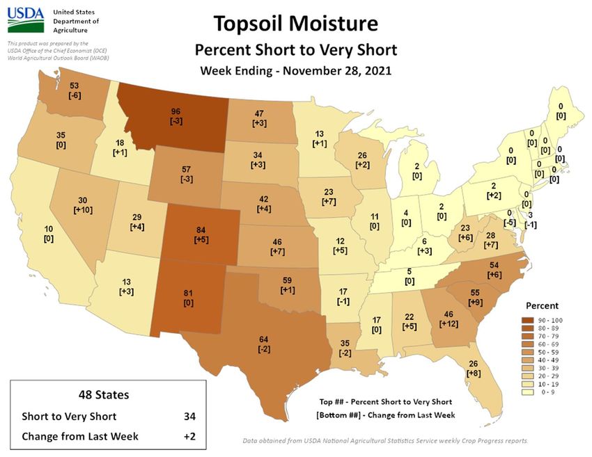
Soil Moisture, Streamflow and Drought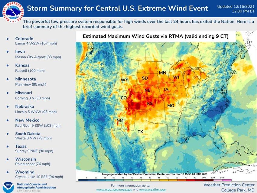
November Temperature Ranks

http://www.ncdc.noaa.gov/temp-and-precip/us-maps/
Year-To-Date Temperature Ranks

 http://www.ncdc.noaa.gov/temp-and-precip/us-maps/
November Precipitation Ranks

http://www.ncdc.noaa.gov/temp-and-precip/us-maps/

Year-To-Date Precipitation Ranks

 http://www.ncdc.noaa.gov/temp-and-precip/us-maps/
https://hprcc.unl.edu/maps.php?map=ACISClimateMaps
https://hprcc.unl.edu/maps.php?map=ACISClimateMaps
https://weather.msfc.nasa.gov/cgi-bin/basicLooper.pl?category=lis_CONUS&initialize=first®ex=vsm0-200percent_20201118
Figure Credit: Brad Rippey – USDA OCE/USDA NASS Data
https://droughtmonitor.unl.edu/Maps/ChangeMaps.aspx
Growing Season Progress
USDA NASS Reporting period has ended, though still harvest ongoing last week in OH and MI

                                               Figure Credit: Brad Rippey – USDA OCE/USDA NASS Data
Figure Credit: Brad Rippey – USDA OCE/USDA NASS Data
Figure Credit: Brad Rippey – USDA OCE/USDA NASS Data
Minnesota/North
Dakota Sugar Beets
Snow, Fire, Rivers and Lakes

                               Photo credit: Karen Nicolas
https://www.nohrsc.noaa.gov/nsa/
https://www.wcc.nrcs.usda.gov/ftpre
f/data/water/wcs/gis/maps/west_sw
       epctnormal_update.pdf
• Significant potential
across parts of
Montana
• Most of the area
within red ellipse
has large
precipitation
deficits as reflected
in D3-D4 conditions
https://www.predictiveservices.nifc.gov/outlooks/outlooks.htmMissouri River
Missouri Mainstem Reservoir
Status (as of 12/16/21):
• System storage is below 50.0
million-acre feet and running below
2012
• 5.0 million-acre feet off the 1969-
2020 average
• The Gavins Point release is currently
12,000 cfs.
• 10th lowest runoff year on record (1898)
http://www.nwd-mr.usace.army.mil/rcc/reports/pdfs/weeklyupdate_previous.pdf28-day Average Streamflow http://waterwatch.usgs.gov/index.php?id=pa07d
Great Lakes Water Levels

                                                 • All Great Lakes running near
                                                   their long-term averages
                                                 • They have dropped from higher
                                                   levels over the last several years
                                                 • Forecasted levels over the next
                                                   six months should remain near
                                                   the long-term average

            https://www.glerl.noaa.gov/data/wlevels/data/superiorLevelsFeet.png
Impacts and Notable Events
State Impacts
                            • Snow pack had been rapidly
                              decreasing in CO until a recent event at
                              brought totals to near-normal
                            • Large wildfires across portions of
                              Montana
                            • Wild and unprecedented severe
                              weather outbreaks across
                              MO/IL/AR/KY and IA/WI/MN

Photo Credit: Accuweather
State Impacts
• A rare dust storm known as a “haboob”
impacted Denver on Dec. 5th.
• Greatly diminished sunlight for good period of time
along with high winds
• At this point, Denver had yet to see its first snowfall State Climatology Office
of the season
• Broke the record length of 233 consecutive • Heavy snow event across
days with no snow. southern MN on Dec. 10-
• Dust storm in eastern CO yesterday 11
The Denver Post • Up to 21” fell in the SW
corner
• I-35 shut down multiple
times
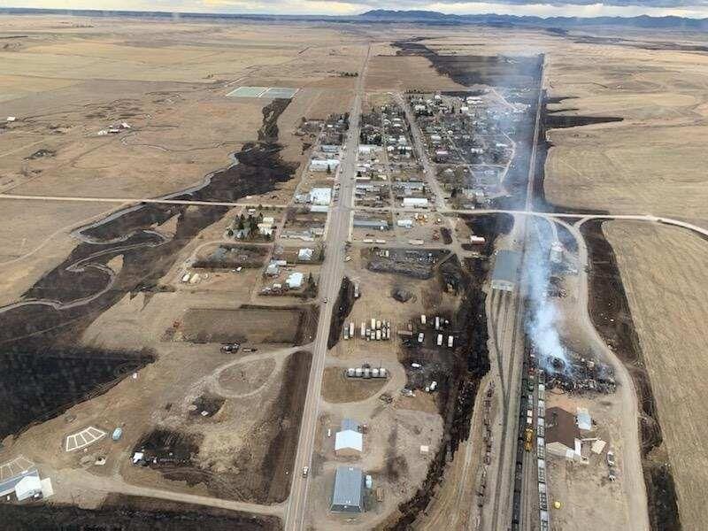
• A late-season wildfire in central Montana • Over 300 car wrecks
incinerated much of the small farming town
of Denton in early December. • Snowfall rates
• The fire, fueled by high winds and unfettered by approaching 2”/hour
any snow, consumed vegetation desiccated by
exceptional drought, melted rail cars
• Destroyed more than two dozen homes and four
grain elevators that had stood for more than a
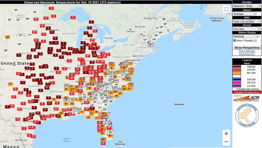
century NBC MontanaStation Extremes: • Hettinger, ND broke a daily hig- temperature record of 71°F on Dec. 1, which is also the state record for a December day. The previous record was 70°F that was broken on December 20, 1894 in Napoleon, ND. • Several stations in Iowa broke December’s record high of 74 degrees on Dec. • Many stations throughout the Midwest broke daily highs and lows as well as dewpoint records on the Photo: National Park Service 15th
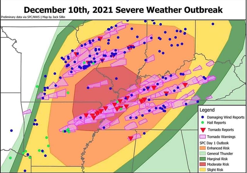
Severe Weather
                 Bryon Houlgrave, The Des Moines Register
• A historic long-track tornado entered western Kentucky from Tennessee shortly before 9:00 pm • Path length estimate at 190 miles at EF-4 • The tornado continued northeast through Mayfield, KY about 9:25 to 9:30 PM CST, where it produced widespread destruction. • More than 80 feared dead with many unaccounted
MO-IL Tornadoes
                  • Worst of the tornadoes was an
                    EF-3 that set down in the St.
                    Louis Metro East and seriously
                    damaged an Amazon warehouse
                    in Edwardsville.
                  • So far there have been 6
                    confirmed fatalities and several
                    injuries.
                  • This event was the first in 4
                    years with a tornado-related
                    death in Illinois.
15 December Event
• First Moderate Risk area in the IA/MN/WI
region during the month of December in SPC
history.
• Widespread damage from severe
thunderstorms with wind gusts exceeding 70
mph
• Multiple reports of 80 MPH winds with
thunderstorms
• Multiple reports of 70+ MPH with non-
thunderstorm winds
• At least 5 tornadoes in Iowa; surveys may
reveal more
• 1 fatality with blown over semi-truckDecember 16, 2021
Summary of 12/15/2021 Severe Weather 6:58 AM
Historical Context
● Prior to 12/15/2021, only 5 confirmed ● Dating back to 1990, this was the 1st
tornadoes in the month of December in Iowa Moderate Risk issued by NWS SPC for Iowa
- 1 in 1975 in the month of December
- 1 in 1982
- 2 in 2015 ● High Wind Warnings for non-thunderstorm
- 1 in 2017 winds are not issued frequently in Iowa,
sometimes less than 3 times per year!
● Dating back to 2004, the 55+ reports of
Significant Wind Gusts 75+ MPH is the most
ever for the lower 48 United States,
surpassing the 2020 Derecho of 53 reports
● Iowa’s Warmest December Temperature
Record Broken Yesterday
- Previous: 74°F in Thurman, IA 12/06/1939
- Yesterday: 75°F in Ottumwa, IA (not all
reports are in yet)
National Weather Service
Des Moines, Iowa• The first Extremely Critical Fire Weather Outlook for the Southern and Central Plains during December in SPC history. • Dangerous, life-threatening fire weather conditions are likely with fast moving and uncontrollable fire spread due to extreme winds and dry conditions.
https://twitter.com/NWSWPC/status/1471531145816952832/photo/1
• La Niña
           • 7-day Precipitation Forecast
           • U.S. Hazard Outlooks
           •
Climate    •
             8 – 14 day Outlook
             December temperature and
Outlooks     precipitation
           • JFM temperature and precipitation
           • MAM temperature and precipitation
La Niña Advisory
• In October, the tropical Pacific and
atmosphere both indicated a
strengthening La Niña
• Moderate phase forecasted at 59%
• Second La Niña in two years, known as
a Double-Dip La Niña
• La Niña is likely to continue across the
Northern Hemisphere 2021-22 winter
• ~95% chance during January-
March and into spring 2022
• ~60% chance of transitions to
ENSO- neutral during Spring 2022
•
https://www.climate.gov/news-features/blogs/enso/november-2020-la-ni%C3%B1a-update-just-us-chickens7-day Quantitative Precipitation Forecast
Valid: 16 Dec. – 23 Dec.
https://www.wpc.ncep.noaa.gov/qpf/day1-7.shtml8-14 Day Outlook
Temperature Precipitation
http://www.cpc.ncep.noaa.gov/products/predictions/814day/https://www.cpc.ncep.noaa.gov/products/predictions/threats/temp_probhazards_d8_14_contours.png
January Outlooks

             Temperature                                  Precipitation
     http://www.cpc.ncep.noaa.gov/products/predictions/long_range/lead14/
JFM 2022 Outlooks https://www.cpc.ncep.noaa.gov/products/predictions/long_range/
MAM 2022 Outlooks

https://www.cpc.ncep.noaa.gov/products/predictions/90day/
Seasonal Drought Outlook

http://www.cpc.ncep.noaa.gov/products/expert_assessment/season_drought.png
Outlook Summary
• Short-term outlooks showing colder and wetter north to warmer and
  drier south
• Classic La Niña signal showing in updated monthly and seasonal
  outlooks
   •   High probability of a weak to moderate La Niña
   •   We shouldn’t expect major changes in the maps moving forward
   •   Analog years show high variability in temperature and precipitation
   •   Some of the biggest signals from La Niña will be late winter and early spring,
       especially across the Ohio Valley and Great Lakes – wet.
Further Information - Partners
• Today’s and Past Recorded Presentations:
https://mrcc.purdue.edu/multimedia/webinars.jsp
http://www.hprcc.unl.edu
• NOAA’s National Centers for Environmental Information: www.ncdc.noaa.gov
Monthly climate reports (U.S. & Global): www.ncdc.noaa.gov/sotc/
• NOAA’s Climate Prediction Center: www.cpc.ncep.noaa.gov
• Climate Portal: www.climate.gov
• U.S. Drought Portal: www.drought.gov
• National Drought Mitigation Center: http://drought.unl.edu
• State climatologists
• http://www.stateclimate.org
• Regional climate centers
• https://mrcc.purdue.edu
• http://www.hprcc.unl.eduThank You and Questions?
• Questions:
• Climate:
• Justin Glisan: justin.glisan@iowaagriculture.gov , 515-281-8981
• Dennis Todey: dennis.todey@usda.gov , 515-294-2013
• Doug Kluck: doug.kluck@noaa.gov, 816-994-3008
• Melissa Widhalm: mwidhalm@purdue.edu ; 765-494-8191
• Brian Fuchs: bfuchs2@unl.edu 402-472-6775
• Weather:
• crhroc@noaa.govYou can also read