Notices to Mariners - Monthly Western Edition - Edition No. 02/2021 February 26, 2021 - NOTMAR
←
→
Page content transcription
If your browser does not render page correctly, please read the page content below
Notices to Mariners

                    Edition No. 02/2021
                       February 26, 2021

Monthly Western Edition
Notices to Mariners – Monthly Western Edition
Edition No. 02/2021
Aussi disponible en français :
Avis aux navigateurs – Édition mensuelle de l’Ouest
Édition n° 02/2021
Published under the Authority of:
Canadian Coast Guard Programs
Aids to Navigation and Waterways
Fisheries and Oceans Canada
Montreal, QC H2Y 2E7
For more information, contact Notmar.XNCR@dfo-mpo.gc.ca.
© Her Majesty the Queen in Right of Canada,
as represented by the Minister of Fisheries, Oceans
and the Canadian Coast Guard, 2021.
Cat. No. Fs152-6E-PDF (Electronic PDF, English)
ISSN 1719-7708
Cat. No. Fs152-6F-PDF (Electronic PDF, French)
ISSN 1719-7716
A web version is available here:
https://www.notmar.gc.ca/monthly-mensuel-en.php (English)
https://www.notmar.gc.ca/monthly-mensuel-fr.php (French)
Notices to Mariners – Monthly Western Edition
                                                         Explanatory Notes – Notices to Mariners (NOTMAR)

                    Explanatory Notes – Notices to Mariners (NOTMAR)
Geographical positions refer directly to the graduations of the largest scale Canadian Hydrographic
Service chart (unless otherwise indicated).

Bearings refer to the true compass and are measured clockwise from 000° (North) clockwise to 359°; those
relating to lights are from seaward.
Visibility of lights is that in clear weather.

Depths - The units used for soundings (metres, fathoms or feet) are stated in the title of each chart.

Elevations are normally given above Higher High Water, Large Tide (unless otherwise indicated).
Distances may be calculated as follows:
 1 nautical mile = 1,852 metres (6,076.1 feet)
 1 statute mile    = 1,609.3 metres (5,280 feet)
 1 metre           = 3.28 feet

Temporary and Preliminary Notices to Mariners – Section 1A of Notices to Mariners
These notices are indicated by a (T) or a (P), respectively. Please note that nautical charts are not amended
by the Canadian Hydrographic Service for temporary (T) and preliminary (P) notices. It is recommended that
mariners chart these corrections in pencil. For the list of charts affected by (T) & (P) notices, please refer to
the current Notices to Mariners - Monthly Summary of Temporary and Preliminary Notices publication.

Please note: In addition to the temporary and preliminary changes normally advertised as (T) & (P) notices,
there are a few permanent changes to aids to navigation that have been advertised as preliminary Notices
to Mariners while charts are being updated for new editions.

Marine Information Report and Suggestion Sheet
Mariners are requested to notify the responsible authorities when new or suspected dangers to navigation
are discovered, changes observed in aids to navigation or corrections to publications are seen to be
necessary. Such communications can be made using the “Marine Information Report and Suggestion Sheet”
(fillable PDF form) and is inserted on the last page of each monthly edition of Notices to Mariners.

NOTMAR Website – Monthly Editions, Chart Corrections and Chart Patches
The NOTMAR website allows users to access the monthly publications, chart corrections, and chart patches.

Users can subscribe for free to the email notification service to receive notifications when charts of interest
are updated, including their patches, as well as when a new monthly edition becomes available online.

In addition, the monthly publication and related files to download, such as chart patches and Sailing
Directions diagrams, can be obtained all together through the download of a single ZIP file.

Edition No. 02/2021 – 2021-02-26                                                                          Page i
Notices to Mariners – Monthly Western Edition
Explanatory Notes – Canadian Hydrographic Service (CHS)
Explanatory Notes – Canadian Hydrographic Service (CHS)
Chart Corrections – Section 2 of Notices to Mariners
Corrections to nautical charts will be listed in numerical order by chart number. Each chart correction listed
applies only to that particular chart. Related charts, if any, will have their own specific correction listed
separately.
Users should also refer to CHS Chart 1: Symbols, Abbreviations and Terms for additional information
pertaining to the correction of charts.
The illustration below describes the elements that will comprise a typical Section 2 chart correction:
The last correction number is identified with the LNM/D or Last Notice to Mariners Number / Date.
Mariners are advised that only the most critical changes that directly affect safety to navigation are issued
in “Section 2 – Chart Corrections.” This limitation is required to ensure that charts remain as clear and easy
to read as possible. As a result, mariners may see minor discrepancies of a non-critical nature between
information in official publications. For example, a small change in the nominal range or focal height of a
light may not result in the production of a chart correction in Notices to Mariners, but may result in a correction
in the List of Lights, Buoys and Fog Signals publication.
Note: In the case of a discrepancy between information provided on CHS charts relating to aids to navigation,
and the List of Lights, Buoys and Fog Signals publication, the latter shall be deemed as containing the most
up-to-date information.
Canadian Nautical Charts & Publications
A source list of Canadian nautical charts and publications is published in Notice No. 14 of the Notices to
Mariners Annual Edition 2020. The source supply and the prices effective at the time of printing are listed.
For current chart edition dates, please refer to the following website: www.chs-shc.gc.ca/charts-
cartes/paper-papier/index-eng.asp.
Edition No. 02/2021 – 2021-02-26 Page iiNotices to Mariners – Monthly Western Edition
Explanatory Notes – Marine Communications and Traffic Services (MCTS)
Explanatory Notes – Marine Communications and Traffic Services (MCTS)
Navigational Warnings / Notices to Shipping
The Canadian Coast Guard (CCG) is implementing a number of changes to the aids to navigation system
in Canada.
These changes are advertised as Navigational Warnings, formerly called Notices to Shipping 1, that are
broadcast by the CCG, and are then followed up with Notices to Mariners, then charts are updated by hand
correction, reprints or new editions.
Mariners are advised that all relevant Navigational Warnings (NAVWARNs) should be kept until superseded
by Notices to Mariners or through revised charts issued by the Canadian Hydrographic Service (CHS).
NAVWARNs are accessible on the applicable regional page on the CCG Navigational Warnings website at
http://nis.ccg-gcc.gc.ca.
CHS is reviewing the impact of these changes with CCG and together are preparing an action plan on the
issuing of chart revisions.
For further information, contact your regional NAVWARN Issuing Desk.
Western Region Arctic Region
Prince Rupert MCTS Centre *Iqaluit MCTS Centre
Operational from approximately mid-May until
“P” Series NAVWARNs
late December.
Canadian Coast Guard
“A” and “H” Series NAVWARNs
Bag 4444
Prince Rupert, BC V8J 4K2 Canadian Coast Guard
P.O. Box 189
Telephone: 250-627-3070
Iqaluit, NU X0A 0H0
Email: NAVWARN.MCTSPrinceRupert@innav.gc.ca
“A” Series NAVWARNs
Telephone: 867-979-5269
“H” Series NAVWARNs
Telephone: 867-979-0310
Facsimile: 867-979-4264
Email: NAVWARN.MCTSIqaluit@innav.gc.ca
*Service available in English and in French.
1 The expression “Notice to Shipping” was changed to “Navigational Warning” in January 2019.
Edition No. 02/2021 – 2021-02-26 Page iiiNotices to Mariners – Monthly Western Edition
Table of Contents
Table of Contents
Section 1: General and Safety Information 1
Canadian Coast Guard Publication – Comments and Suggestions on Notices To Mariners (NOTMAR)
Publications ............................................................................................................................ 1
Transport Canada – COVID-19 Measures, Updates and Guidance ....................................................... 1
Canadian Hydrographic Service – Canadian Tide and Current Tables – Printing to be Discontinued .. 1
Canadian Hydrographic Service – Chart 1 – Printing to be Discontinued .............................................. 1
Canadian Hydrographic Service – Notices to Mariners for Changes in Buoy Shape ............................. 2
West Coast Haida Gwaii – Trial Voluntary Protection Zone for Shipping ............................................... 2
*201/21 Canadian Hydrographic Service – Nautical Charts................................................................ 3
*202/21 Canadian Hydrographic Service – Electronic Navigational Charts ........................................ 3
*203/21 Canadian Hydrographic Service – Raster Digital Charts (BSB V3) ....................................... 4
*204/21 Transport Canada – Ship Safety Bulletin #02/2021 ............................................................... 4
*205/21 Canadian Coast Guard Publication – Annual Edition of Notices to Mariners 2021 ............... 5
Section 1A: Temporary and Preliminary Notices 6
*208(T)/21 Canadian Coast Guard – Automatic Identification System (AIS) ..................................... 6
Section 2: Chart Corrections 7
Section 3: Radio Aids to Marine Navigation Corrections 11
*209/21 Radio Aids to Marine Navigation 2021 (Atlantic, St. Lawrence, Great Lakes,
Lake Winnipeg, Arctic and Pacific) ....................................................................................... 11
Section 4: Sailing Directions and Small Craft Guide Corrections 13
Section 5: List of Lights, Buoys and Fog Signals Corrections 18
Edition No. 02/2021 – 2021-02-26 Page ivNotices to Mariners – Monthly Western Edition
Numerical Index of Canadian Charts Affected
Numerical Index of Canadian Charts Affected
This numerical index lists all nautical charts mentioned in this monthly edition of Notices to Mariners. Only
charts appearing in Section 2 of this publication require a chart correction. The appearance of charts in all
other sections, particularly those related to the correction of other nautical publications, is included here for
reference.
Chart No. Pages Chart No. Pages Chart No. Pages
3000 7
3002 7
3311 3
3312 3, 7
3313 3, 8
3441 15
3442 8, 15
3443 8, 15
3475 15
3477 15
3478 8
3493 18
3513 9
3538 9
3539 9
3543 16
3555 15, 16
3671 9, 10
3795 10
3811 10
3978 10
4429 3, 4
5338 3, 4
Edition No. 02/2021 – 2021-02-26 Page vNotices to Mariners – Monthly Western Edition
Erreur ! Utilisez l'onglet Accueil pour appliquer Heading 1 au texte que vous souhaitez faire
apparaître ici.
Section 1: General and Safety Information
Canadian Coast Guard Publication – Comments and Suggestions on Notices To Mariners
(NOTMAR) Publications
In an effort to continuously improve the Notices to Mariners publications and to provide the most efficient
service possible, the Notices to Mariners team invites all mariners and other interested parties to submit
comments and suggestions on possible improvements to its various publications and services at the
following email address: Notmar.XNCR@dfo-mpo.gc.ca.
Transport Canada – COVID-19 Measures, Updates and Guidance
(Recurrent publication of notice *401/20, originally published in the Notices to Mariners – Monthly Western Edition
04/2020 publication.)
Please refer to the link below for the latest updates to transportation related measures taken by Transport
Canada in response to the evolving novel Coronavirus disease (COVID-19):
https://www.tc.gc.ca/en/initiatives/covid-19-measures-updates-guidance-tc.html.
For travel advice and all other updates, please visit: Canada.ca/coronavirus.
Canadian Hydrographic Service – Canadian Tide and Current Tables – Printing to be
Discontinued
(Recurrent publication of notice *904/20, originally published in the Notices to Mariners – Monthly Western Edition
09/2020 publication.)
Due to the availability of the Canadian Tide and Current Tables as viewable and printable PDF files on
charts.gc.ca for each complete volume and additional information in different formats (predictions,
observations in tables, and graphics) on tides.gc.ca, the Canadian Hydrographic Service is permanently
discontinuing the printing of all volumes of Canadian Tide and Current Tables starting January 2021.
Advances in technology bring a new era of marine navigation with a focus on digital and electronic products.
The Canadian Hydrographic Service is transforming the way it delivers quality data and services to clients,
in a timely manner, to support decision-making.
For more information, visit www.charts.gc.ca.
Canadian Hydrographic Service – Chart 1 – Printing to be Discontinued
(Recurrent publication of notice *905/20, originally published in the Notices to Mariners – Monthly Western Edition
09/2020 publication.)
Due to the availability of Chart 1: Symbols, Abbreviations and Terms as both viewable and printable PDF
files and HTML format on charts.gc.ca, the Canadian Hydrographic Service is permanently discontinuing the
printing of Chart 1: Symbols, Abbreviations and Terms starting January 2021.
Advances in technology bring a new era of marine navigation with a focus on digital and electronic products.
The Canadian Hydrographic Service is transforming the way it delivers quality data and services to clients,
in a timely manner, to support decision-making.
For more information, visit www.charts.gc.ca.
Edition No. 02/2021 – 2021-02-26 Page 1Notices to Mariners – Monthly Western Edition
Erreur ! Utilisez l'onglet Accueil pour appliquer Heading 1 au texte que vous souhaitez faire
apparaître ici.
Canadian Hydrographic Service – Notices to Mariners for Changes in Buoy Shape
(Recurrent publication of notice *906/20, originally published in the Notices to Mariners – Monthly Western Edition
09/2020 publication.)
As part of the CHS Digital Transformation and for the sake of economy, CHS will no longer systematically
issue Notices to Mariners (NTM) for buoy shape changes only. These changes will, however, be applied to
electronic navigation charts (ENCs) where applicable. The paper and raster versions will be updated during
the New Edition process.
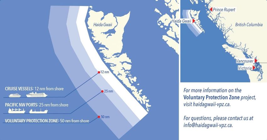
West Coast Haida Gwaii – Trial Voluntary Protection Zone for Shipping
(Recurrent publication of notice *107/21, originally published in the Notices to Mariners – Monthly Western Edition
01/2021 publication.)
Reference: Notice *1005/20 is cancelled.
Trial Voluntary Protection Zone for Shipping, West Coast Haida Gwaii (formerly Queen Charlotte Islands)
Haida Gwaii’s remote location, rugged coastline, variable sea and weather conditions, and rich ecological
and cultural heritage make it vulnerable to the potential for pollution from shipping breakdowns and
accidents. Increasing the distance vessels travel offshore can increase the amount of time available to
address propulsion, steering or other issues, and the likelihood of a towing vessel being able to respond to
a vessel that is disabled or drifting. This in turn reduces the risk of grounding and oil spills.
A trial Voluntary Protection Zone for Shipping on the West Coast of Haida Gwaii will be in effect from
September 1, 2020 through October 31, 2021. In the Voluntary Protection Zone, commercial vessels of 500
gross tonnage or greater shall observe a minimum distance of 50 nautical miles offshore when transiting
along the West Coast of Haida Gwaii with the following exceptions:
– Cruise vessels, to observe a minimum 12 nm distance from shore;
– Vessels transiting between Pacific Northwest ports (Washington, Alaska, BC), to observe a minimum
25 nm distance from shore;
– Tugs and barges (including pushing and towing alongside), no minimum distance; and
– Fishing vessels, no minimum distance.
Edition No. 02/2021 – 2021-02-26 Page 2Notices to Mariners – Monthly Western Edition
Erreur ! Utilisez l'onglet Accueil pour appliquer Heading 1 au texte que vous souhaitez faire
apparaître ici.
The Voluntary Protection Zone for Shipping coordinates are:
54⁰ 18.108’N 134⁰ 30.432’W
53⁰ 44.036’N 134⁰ 32.677’W
53⁰ 11.118’N 134⁰ 16.412’W
52⁰ 18.483’N 133⁰ 20.917’W
51⁰ 24.590’N 132⁰ 04.081’W
51⁰ 56.158’N 131⁰ 01.830’W
54⁰ 15.436’N 133⁰ 04.788’W
Vessels are requested to adhere to these distances on a voluntary basis and only when it does not jeopardize
the safety of navigation, the vessel, the persons aboard, and the cargo.
(NW-P-1085-20)
*201/21 Canadian Hydrographic Service – Nautical Charts
Charts Main Title Scale Published Cat# Price
New Editions
Havre Saint-Pierre et les approches/and
4429 1:20 000 2021-02-12 1 $20.00
Approaches
5338 Rivière Koksoak 1:30 000 2021-02-26 4 $20.00
Charts Permanently Withdrawn
Sunshine Coast, Vancouver Harbour to/à
3311
Desolation Sound
Jervis Inlet & Desolation Sound and Adjacent
3312
Waterways/et les voies navigables adjacentes
Gulf Islands and Adjacent Waterways/et les Voies
3313
Navigables Adjacentes
*202/21 Canadian Hydrographic Service – Electronic Navigational Charts
ENC Compilation
S-57 ENC Number Chart Title Published
Scale
New Charts
CA570752 (Edn 1.000) Alberni Inlet (Part 1 of 3) 1:6 000 2021-02-05
CA570753 (Edn 1.000) Alberni Inlet (Part 2 of 3) 1:6 000 2021-02-05
CA570754 (Edn 1.000) Alberni Inlet (Part 3 of 3) 1:6 000 2021-02-05
Masset Harbour and Approaches / et les
CA571005 (Edn 1.000) 1:11 000 2021-02-26
approches (Part 1 of 6)
Masset Harbour and Approaches / et les
CA571006 (Edn 1.000) 1:11 000 2021-02-26
approches (Part 2 of 6)
Masset Harbour and Approaches / et les
CA571007 (Edn 1.000) 1:11 000 2021-02-26
approches (Part 3 of 6)
Masset Harbour and Approaches / et les
CA571009 (Edn 1.000) 1:11 000 2021-02-26
approches (Part 4 of 6)
Edition No. 02/2021 – 2021-02-26 Page 3Notices to Mariners – Monthly Western Edition
Erreur ! Utilisez l'onglet Accueil pour appliquer Heading 1 au texte que vous souhaitez faire
apparaître ici.
ENC Compilation
S-57 ENC Number Chart Title Published
Scale
Masset Harbour and Approaches / et les
CA571010 (Edn 1.000) 1:11 000 2021-02-26
approches (Part 5 of 6)
Masset Harbour and Approaches / et les
CA571011 (Edn 1.000) 1:11 000 2021-02-26
approches (Part 6 of 6)
CA576504 (Edn 1.000) Musgrave Harbour 1:3 000 2021-02-19
CA576601 (Edn 1.000) Black Island Tickle 1:3 000 2021-02-12
New Editions
CA479006 (Edn 12.000) Baie des Sept-Îles 1:12 500 2021-02-12
CA570153 (Edn 8.000) Chemainus Bay 1:6 000 2021-02-05
CA570154 (Edn 6.000) Ladysmith Harbour 1:6 000 2021-02-05
CA570155 (Edn 8.000) Osborn Bay 1:7 500 2021-02-05
CA570168 (Edn 6.000) Port Alberni 1:6 000 2021-02-05
CA573471 (Edn 2.000) Daniel Island Harbour 1:9 000 2021-02-05
Port de Montréal - Repentigny à/to Montréal
CA579001 (Edn 13.000) 1:7 500 2021-02-12
Est
CA579007 (Edn 10.000) Pointe-Noire 1:5 000 2021-02-12
CA579008 (Edn 10.000) Sept-Îles 1:5 000 2021-02-12
*203/21 Canadian Hydrographic Service – Raster Digital Charts (BSB V3)
Charts Main Title Scale Published
New Editions
Havre Saint-Pierre et les approches/and
4429 1:20 000 2021-02-12
Approaches
5338 Rivière Koksoak 1:30 000 2021-02-26
*204/21 Transport Canada – Ship Safety Bulletin #02/2021
A new Ship Safety Bulletin has recently been posted on the Transport Canada website at
www.tc.gc.ca/ssb-bsn/.
To view or download this bulletin, please click on the links below:
SSB#02/2021 – Request for notification of any person or crew member on board that has a serious
illness or any COVID-19 symptoms
RDIMS#17048601
Sign up for e-Bulletin to receive an e-mail notice each time a new Ship Safety Bulletin is published on our
website.
Contact us at marinesafety-securitemaritime@tc.gc.ca or 1-855-859-3123 (Toll Free).
Edition No. 02/2021 – 2021-02-26 Page 4Notices to Mariners – Monthly Western Edition
Erreur ! Utilisez l'onglet Accueil pour appliquer Heading 1 au texte que vous souhaitez faire
apparaître ici.
*205/21 Canadian Coast Guard Publication – Annual Edition of Notices to Mariners 2021
The Annual Edition of Notices to Mariners 2021 is now available for free download, on the NOTMAR website
at https://www.notmar.gc.ca/annual-annuel-en.php.
Paper copies of this publication are no longer sold. This printable online version is kept up to date.
Amendments to this publication are advertised in Section 1 of the monthly editions of Notices to Mariners
(https://www.notmar.gc.ca/monthly-mensuel-en.php).
The 2021 edition has been revised up to February 26, 2021 and supersedes the 2020 edition.
Edition No. 02/2021 – 2021-02-26 Page 5Notices to Mariners – Monthly Western Edition
Erreur ! Utilisez l'onglet Accueil pour appliquer Heading 1 au texte que vous souhaitez faire
apparaître ici.
Section 1A: Temporary and Preliminary Notices
Reminder – Comment Period for Active Preliminary Notices
No notices applicable for this edition.
Inland Waters
No notices applicable for this edition.
Pacific Coast
No notices applicable for this edition.
Other (T) & (P) Notices
Temporary Notices
*208(T)/21 Canadian Coast Guard – Automatic Identification System (AIS)
Reference: Notice *819(T)/16 is cancelled.
AIS Aids to Navigation (AtoNs)
Mariners are advised that the Canadian Coast Guard (CCG) is continuing to conduct supervised test beds
of AIS AtoNs, with the objective of bringing AIS AtoNs to Full Operational Capability (FOC). Specific
information on AIS AtoN test bed sites can be found on the CCG e-Navigation Maritime Information Portal
at http://www.marinfo.gc.ca/e-nav/docs/ais-aton-locations-eng.php.
Although AIS was originally developed as a collision avoidance tool for vessels, it also allows for the
broadcasting of other types of data, such as the AIS AtoN “Message 21” (AIS AtoN Report).
Ships need to be equipped with standard shipborne AIS equipment for the display of AIS messages. The
IMO mandatory carriage requirement for the Class “A” AIS display is the Minimum Keyboard Display (MKD),
however, the display and use of the AtoN information may require additional hardware and/or software such
as an AIS-connected Electronic Chart Display and Information System (ECDIS), Electronic Chart System
(ECS), Radar or Portable Pilot Unit (PPU).
As the AIS information available to mariners will be dependent on their display system and its compliance
with the latest IMO and IALA standards, some transmitted information may not be displayed or may have a
different symbol. Mariners are encouraged to install and upgrade systems that provide AIS overlay on
ECDIS, ECS and/or Radar. Mariners should be familiar with the display settings on their vessel’s shipborne
equipment.
All geographical positions (latitude and longitude) are based on the WGS 84 datum; time is displayed in
Coordinated Universal Time (UTC).
CCG is making every effort to broadcast quality information; however, as with any navigational tool, mariners
should not rely on this information as their sole means of navigation.
Mariners are advised to consult the CCG e-Navigation web page on AIS AtoN, accessible at
http://www.marinfo.gc.ca/e-nav/docs/ais-aton-index-eng.php for pertinent information, including examples of
AIS AtoN display and symbology.
Individual NAVWARNs and/or NOTMARs are rarely issued for AIS AtoN trials.
Mariners are requested to provide feedback on the AIS AtoN test beds to the CCG e-Navigation Team at
ccg.enav.gcc@dfo-mpo.gc.ca. In addition, mariners who wish to participate in CCG’s questionnaire on AIS
AtoN are invited to access it at http://www.marinfo.gc.ca/e-nav/docs/asm-aton-survey-eng.php. The
collected results will guide the CCG in further developing this information service.
Edition No. 02/2021 – 2021-02-26 Page 6Notices to Mariners – Monthly Western Edition
Erreur ! Utilisez l'onglet Accueil pour appliquer Heading 1 au texte que vous souhaitez faire apparaître ici.
Section 2: Chart Corrections
3000 - Juan de Fuca Strait to/à Dixon Entrance - New Edition - 20-JAN-1989 - NAD 1927
26-FEB-2021 LNM/D. 06-NOV-2020
Add VOLUNTARY PROTECTION ZONE A Trial Voluntary Protection Zone 54°11′00.0″N 126°00′00.0″W
for Shipping on the West Coast of Haida Gwaii is in effect from
September 1, 2020 through October 31, 2021. Commercial vessels of
500 gross tonnage or greater shall observe a minimum distance of 50
nautical miles offshore when transiting with a few exceptions. For
additional information, see monthly Notice to Mariners or haidagwaii-
vpz.ca.
ZONE DE PROTECTION VOLONTAIRE Une zone de protection
volontaire pour le transport sur la côte ouest de l’archipel Haida Gwaii
sera instaurée du 1er septembre 2020 au 31 octobre 2021 dans le cadre
d’un essai. Dans cette zone, les bâtiments commerciaux de 500
tonneaux (jauge brute) ou plus doivent se trouver à au moins 50 mille
marins de la côte lorsqu’ils transitent le long de la côte ouest de
l’archipel Haida Gwaii, à quelques exemptions près. Pour en savoir plus
sur le projet de zone de protection volontaire, consultez l’Avis aux
navigateurs mensuel ou le site haidagwaii-vpz.ca.
This notice affects Electronic Navigational Chart: CA270390
DFO(6204420-01)
3002 - Queen Charlotte Sound to/à Dixon Entrance - New Edition - 16-DEC-1994 - NAD 1927
26-FEB-2021 LNM/D. 25-DEC-2020
Add VOLUNTARY PROTECTION ZONE A Trial Voluntary Protection Zone 53°06′00.0″N 128°00′00.0″W
for Shipping on the West Coast of Haida Gwaii is in effect from
September 1, 2020 through October 31, 2021. Commercial vessels of
500 gross tonnage or greater shall observe a minimum distance of 50
nautical miles offshore when transiting with a few exceptions. For
additional information, see monthly Notice to Mariners or haidagwaii-
vpz.ca.
ZONE DE PROTECTION VOLONTAIRE Une zone de protection
volontaire pour le transport sur la côte ouest de l’archipel Haida Gwaii
sera instaurée du 1er septembre 2020 au 31 octobre 2021 dans le cadre
d’un essai. Dans cette zone, les bâtiments commerciaux de 500
tonneaux (jauge brute) ou plus doivent se trouver à au moins 50 mille
marins de la côte lorsqu’ils transitent le long de la côte ouest de
l’archipel Haida Gwaii, à quelques exemptions près. Pour en savoir plus
sur le projet de zone de protection volontaire, consultez l’Avis aux
navigateurs mensuel ou le site haidagwaii-vpz.ca.
This notice affects Electronic Navigational Chart: CA270390
DFO(6204420-01)
3312 - Hoskyn Channel - Sutil Channel - Sheet/Feuille 19 - New Edition - 05-JAN-2007 - NAD 1983
05-FEB-2021 LNM/D. 19-JUN-2020
Add depth of 0.3 metres 50°06′58.4″N 125°04′22.2″W
(See Chart No. 1, I10)
This notice affects Electronic Navigational Chart: CA470017
DFO(6204410-03)
Edition No. 02/2021 – 2021-02-26 Page 7Notices to Mariners – Monthly Western Edition
Erreur ! Utilisez l'onglet Accueil pour appliquer Heading 1 au texte que vous souhaitez faire apparaître ici.
3313 - Stuart Channel South/Sud - Sheet/Feuille 15 - New Edition - 02-JAN-2009 - NAD 1983
05-FEB-2021 LNM/D. 11-DEC-2020
Delete depth of 6.7 metres 48°58′38.5″N 123°34′06.5″W
(See Chart No. 1, I10)
This notice affects Electronic Navigational Chart: CA470070
DFO(6204410-01)
Add depth of 2.3 metres 48°58′38.1″N 123°34′05.8″W
(See Chart No. 1, I10)
This notice affects Electronic Navigational Chart: CA470070
DFO(6204410-02)
3313 - Trincomali Channel - Sheet/Feuille 17 - New Edition - 02-JAN-2009 - NAD 1983
05-FEB-2021 LNM/D. 11-DEC-2020
Delete depth of 6.7 metres 48°58′38.5″N 123°34′06.5″W
(See Chart No. 1, I10)
This notice affects Electronic Navigational Chart: CA470070
DFO(6204410-01)
Add depth of 2.3 metres 48°58′38.1″N 123°34′05.8″W
(See Chart No. 1, I10)
This notice affects Electronic Navigational Chart: CA470070
DFO(6204410-02)
3442 - North Pender Island to/à Thetis Island - New Edition - 01-JUL-2005 - NAD 1983
05-FEB-2021 LNM/D. 10-JAN-2020
Delete depth of 6.7 metres 48°58′38.5″N 123°34′06.5″W
(See Chart No. 1, I10)
This notice affects Electronic Navigational Chart: CA470070
DFO(6204410-01)
Add depth of 2.3 metres 48°58′38.1″N 123°34′05.8″W
(See Chart No. 1, I10)
This notice affects Electronic Navigational Chart: CA470070
DFO(6204410-02)
3443 - Thetis Island to/à Nanaimo - New Edition - 20-DEC-2002 - NAD 1983
05-FEB-2021 LNM/D. 11-DEC-2020
Delete depth of 6.7 metres 48°58′38.5″N 123°34′06.5″W
(See Chart No. 1, I10)
This notice affects Electronic Navigational Chart: CA470070
DFO(6204410-01)
Add depth of 2.3 metres 48°58′38.1″N 123°34′05.8″W
(See Chart No. 1, I10)
This notice affects Electronic Navigational Chart: CA470070
DFO(6204410-02)
3478 - Ganges Harbour and/et Long Harbour - New Edition - 12-JUL-2013 - NAD 1983
05-FEB-2021 LNM/D. 28-JUN-2019
Affix patch 48°51′28.0″N 123°29′59.0″W
Download Patch - https://www.notmar.gc.ca/chsftp/patches/3478_6204411_1_202101051615.pdf
This notice affects Electronic Navigational Chart: CA570239
DFO(6204411-01)
Edition No. 02/2021 – 2021-02-26 Page 8Notices to Mariners – Monthly Western Edition
Erreur ! Utilisez l'onglet Accueil pour appliquer Heading 1 au texte que vous souhaitez faire apparaître ici.
3513 - Strait of Georgia, Northern Portion/Partie Nord - New Edition - 29-OCT-1999 - NAD 1983
26-FEB-2021 LNM/D. 13-MAR-2020
Add depth of 0.6 metres 49°55′48.0″N 124°49′29.3″W
(See Chart No. 1, I10)
This notice affects Electronic Navigational Chart: CA370016
DFO(6204418-03)
Add depth of 0.6 metres 49°55′21.4″N 124°49′35.4″W
(See Chart No. 1, I10)
This notice affects Electronic Navigational Chart: CA370016
DFO(6204418-04)
Add depth of 0.8 metres 49°54′38.5″N 124°44′06.9″W
(See Chart No. 1, I10)
This notice affects Electronic Navigational Chart: CA370016
DFO(6204418-05)
Delete depth of 2.3 metres 49°54′38.4″N 124°44′04.9″W
(See Chart No. 1, I10)
This notice affects Electronic Navigational Chart: CA370016
DFO(6204418-06)
Delete depth of 2.7 metres 49°55′49.4″N 124°49′32.8″W
(See Chart No. 1, I10)
This notice affects Electronic Navigational Chart: CA370016
DFO(6204418-07)
3538 - Desolation Sound and/et Sutil Channel - New Edition - 30-DEC-2005 - NAD 1983
05-FEB-2021 LNM/D. 03-JUL-2020
Add depth of 0.3 metres 50°06′58.4″N 125°04′22.2″W
(See Chart No. 1, I10)
This notice affects Electronic Navigational Chart: CA470017
DFO(6204410-03)
26-FEB-2021 LNM/D. 05-FEB-2021
Add rock which covers and uncovers with drying height of 0.1 metres 49°56′50.9″N 124°52′49.4″W
(See Chart No. 1, K11)
This notice affects Electronic Navigational Chart: CA470103
DFO(6204418-01)
Add rock which covers and uncovers with drying height of 0.1 metres 49°56′48.9″N 124°52′42.2″W
(See Chart No. 1, K11)
This notice affects Electronic Navigational Chart: CA470103
DFO(6204418-02)
3539 - Discovery Passage - New Edition - 30-MAR-2007 - NAD 1983
05-FEB-2021 LNM/D. 19-JUN-2020
Add depth of 0.3 metres 50°06′58.4″N 125°04′22.2″W
(See Chart No. 1, I10)
This notice affects Electronic Navigational Chart: CA470017
DFO(6204410-03)
3671 - Barkley Sound - New Edition - 04-NOV-2005 - NAD 1983
12-FEB-2021 LNM/D. 17-JUL-2020
Add wreck WK with known depth of 25 metres 48°57′17.7″N 125°35′59.2″W
(See Chart No. 1, K26)
This notice affects Electronic Navigational Chart: CA470337
DFO(6204412-01)
Edition No. 02/2021 – 2021-02-26 Page 9Notices to Mariners – Monthly Western Edition
Erreur ! Utilisez l'onglet Accueil pour appliquer Heading 1 au texte que vous souhaitez faire apparaître ici.
Add depth of 0.1 metres 48°57′12.0″N 125°35′45.9″W
(See Chart No. 1, I10)
This notice affects Electronic Navigational Chart: CA470337
DFO(6204412-02)
Add depth of 0.4 metres 48°56′49.0″N 125°35′11.5″W
(See Chart No. 1, I10)
This notice affects Electronic Navigational Chart: CA470337
DFO(6204412-03)
3795 - Langley Passage, Estevan Group - New Edition - 27-MAR-2015 - World Geodetic System 1984
12-FEB-2021 LNM/D. 02-AUG-2019
Delete red starboard hand conical buoy, marked ET2 53°03′30.2″N 129°36′22.1″W
(See Chart No. 1, Qf)
This notice affects Electronic Navigational Chart: CA570722
(P2020045) DFO(6204388-01)
Delete green port hand can buoy, marked ET1 53°03′14.2″N 129°36′46.1″W
(See Chart No. 1, Qg)
This notice affects Electronic Navigational Chart: CA570722
(P2020046) DFO(6204389-01)
Delete green port hand can buoy, marked ET3 53°03′32.2″N 129°38′46.1″W
(See Chart No. 1, Qg)
This notice affects Electronic Navigational Chart: CA470613, CA570722
(P2020047) DFO(6204390-01)
Delete red starboard hand conical buoy, marked ET4 53°02′57.2″N 129°37′21.1″W
(See Chart No. 1, Qf)
This notice affects Electronic Navigational Chart: CA470613, CA570722
(P2020048) DFO(6204391-01)
Delete red starboard hand conical buoy, marked ET6 53°03′08.2″N 129°37′57.1″W
(See Chart No. 1, Qf)
This notice affects Electronic Navigational Chart: CA470613, CA570722
(P2020049) DFO(6204392-01)
3811 - Port Louis and/et Otard Bay - New Edition - 16-MAR-2007 - NAD 1983
19-FEB-2021 LNM/D. 10-AUG-2018
Add depth of 1.4 metres 53°41′39.2″N 133°02′44.3″W
(See Chart No. 1, I10)
DFO(6204417-01)
Add depth of 1 metre 53°41′37.1″N 133°02′16.3″W
(See Chart No. 1, I10)
DFO(6204417-02)
Delete depth of 21.9 metres 53°41′40.0″N 133°02′43.2″W
(See Chart No. 1, I10)
DFO(6204417-03)
3978 - Bonilla Island to/à Edye Passage - New Chart - 01-JUL-2016 - World Geodetic System 1984
26-FEB-2021 LNM/D. 17-JUL-2020
Affix patch 53°25′00.0″N 130°30′00.0″W
Download Patch - https://www.notmar.gc.ca/chsftp/patches/3978_6204359_1_202101201859.pdf
This notice affects Electronic Navigational Chart: CA370440
DFO(6204359-01)
Edition No. 02/2021 – 2021-02-26 Page 10Notices to Mariners – Monthly Western Edition
Erreur ! Utilisez l'onglet Accueil pour appliquer Heading 1 au texte que vous souhaitez faire
apparaître ici.
Section 3: Radio Aids to Marine Navigation Corrections
*209/21 Radio Aids to Marine Navigation 2021 (Atlantic, St. Lawrence, Great Lakes,
Lake Winnipeg, Arctic and Pacific)
Page 2-6
ADD AS FOLLOWS FOR SECTION 2.1.2 UNDER “COORDINATES”:
Email: IQANORDREG@INNAV.GC.CA (East)
Iqamck01@innav.gc.ca (West)
NAVWARN.MCTSIqaluit@innav.gc.ca
Page 2-32
ADD AS FOLLOWS FOR SECTION 2.1.8 UNDER “COORDINATES”:
Email: supervisor.rupert@innav.gc.ca
NAVWARN.MCTSPrinceRupert@innav.gc.ca
Page 4-67
AMEND AS FOLLOWS:
Table 4-15 - Broadcast Schedule
Hour UTC Service Frequency or satellite
0330 HF NBDP 8416.5 kHz*
1100 NAV XVIII AOR-W AMER
1130 NAV XVII POR APAC
1530 HF NBDP 8416.5 kHz*
2300 NAV XVIII AOR-W AMER
2330 NAV XII POR APAC
…
4.3.3.2 NAVAREAS IV and XII
…
NAVAREA IV covers the North Atlantic Ocean West of 35°W and north of 7°N. NAVAREA IV
warnings are broadcasts over the AOR-W AMER satellite at 10:00 UTC and 22:00 UTC. Ice reports
for the North Atlantic are broadcast at 12:00 22:00 UTC. NAVAREA IV warnings are broadcast over
HF NBDP from: Boston (NMF) at 01:40 UTC on 6314 kHz, 8416.5 kHz, and 12579 kHz and at 16:30
UTC on 8416.5 kHz, 12579 kHz, and 16806.5 kHz.
NAVAREA XII covers the North Pacific Ocean east of 180° and north of the equator, plus the area
north of 3°25’S and east of 120°W. NAVAREA XII warnings are broadcasts over the POR APAC
satellite at 10:30 UTC and 22:30 UTC. These messages are broadcast over HF NBDP by Honolulu
(NMO) at 03:30 and 17:30 UTC daily, on 8416.5 kHz, 12579 kHz, and 22376 kHz.
…
Edition No. 02/2021 – 2021-02-26 Page 11Notices to Mariners – Monthly Western Edition
Erreur ! Utilisez l'onglet Accueil pour appliquer Heading 1 au texte que vous souhaitez faire
apparaître ici.
Mariners may also consult the International Maritime Organization (IMO) circular, COMSAR.1/Circ.51,
for an updated list of all NAVAREA Coordinators.
NAVAREA broadcast schedules can be found in Annex 8 of the IMO circular, GMDSS.1/Circ.19 23
(as amended) GMDSS Master Plan of Shore-Based Facilities for GMDSS or the appropriate section
of the GMDSS module of IMO’s Global Integrated Shipping Information System (GISIS).
Edition No. 02/2021 – 2021-02-26 Page 12Notices to Mariners – Monthly Western Edition
Erreur ! Utilisez l'onglet Accueil pour appliquer Heading 1 au texte que vous souhaitez faire apparaître ici.
Section 4: Sailing Directions and Small Craft Guide Corrections
PAC 200 — General Information, Pacific Coast, Second Edition, 2006 —
Chapter 2 — After paragraph 107
Insert: 107.1 Southern Resident Killer Whale Critical
Habitat Areas and Interim Sanctuary Zones. —
Southern Resident Killer Whales are an endangered
species and are protected under the Species at Risk Act.
Stressors on the whales include limited availability of
Chinook salmon, physical and acoustical disturbances, oil
spills, and contaminants. The areas and zones protecting the
whales are in the waters off southwestern Vancouver Island
and the transboundary areas of southern British Columbia
and northern Washington. A lateral displacement area is
within the outbound shipping lane in Juan de Fuca Strait. A
voluntary speed limit of 7 knots is recommended and a
minimum distance of 400 metres/yards (0.215 nautical
miles) should be kept from the whales or any other marine
mammal. For more information see Notices to Mariners
Annual Edition 1 to 46 Section A2, Notice 5.
107.2 Northern Resident Killer Whale Critical
Habitat Areas and Interim Sanctuary Zones. —
Northern Resident Killer Whales are an endangered
species and are protected under the Species at Risk Act.
Stressors on the whales include limited availability of
Chinook salmon, physical and acoustical disturbances, oil
spills, and contaminants. The areas and zones affecting
marine traffic are the continental shelf waters off
southwestern Vancouver Island including Swiftsure Bank
and La Pérouse Bank, southeastern Queen Charlotte Strait,
and the waters of Dixon Entrance along the north coast of
Graham Island from Langara to Rose Spit. A voluntary
speed limit of 7 knots is recommended and a minimum
distance of 400 metres/yards (0.215 nautical miles) should
be kept from the whales or any other marine mammal. For
more information see Notices to Mariners Annual Edition
1 to 46 Section A2, Notice 5.
(P2020-030.01)
INDEX — Before “North Fraser Harbour, C1/P199”
Insert: Northern Resident Killer Whales, C2/P107.2
(P2020-030.02)
INDEX — After “Source Classification Diagram, C4/P50”
Insert: Southern Resident Killer Whales, C2/P107.1
(P2020-030.03)
PAC 201 — Juan de Fuca Strait and Strait of Georgia, First Edition, 2012 —
Chapter 1 — Paragraph 161, last line
Add: A private ODAS light buoy (T’Souke Nation) is
approximately 2.2 miles NW of Otter Point.
(P2020-040.01)
Edition No. 02/2021 – 2021-02-26 Page 13Notices to Mariners – Monthly Western Edition
Erreur ! Utilisez l'onglet Accueil pour appliquer Heading 1 au texte que vous souhaitez faire apparaître ici.
Chapter 1 — Paragraph 163, last line
Add: A private ODAS light buoy (T’Souke Nation) is
approximately 0.6 mile NW of Muir Point.
(P2020-040.02)
Chapter 1 — Paragraph 168, last line
Add: A private ODAS light buoy (T’Souke Nation) is
approximately 0.2 mile SE of Parsons Spit.
(P2020-040.03)
Chapter 1 — Paragraph 176, last line
Add: A private ODAS light buoy (T’Souke Nation) is
approximately 84 m SE of Woodward Point.
(P2020-040.04)
Chapter 1 — Paragraph 202, last line
Add: A private ODAS light buoy (T’Souke Nation) is
approximately 0.2 mile NW of Goodridge Islands.
(P2020-040.05)
Chapter 3 — Paragraph 73, last line
Add: A submarine cable runs 1.25 miles south between Narvaez
Bay and East Point.
(P2020-035.01)
Chapter 3 — Adjacent to paragraph 73, add a caution pictograph.
(P2020-035.02)
Chapter 5 — Paragraph 60
Delete: (South and North)
Replace by: (Inbound and Outbound)
(P2020-024.01)
Chapter 5 — Delete paragraph 69
Replace by: 69 Fixed red lights are shown from the tops of the main
towers. Two fixed white lights are shown on the underside
of the bridge to indicate channel limits. Fixed yellow lights
are shown from the centres of the bases of the two main
towers. Four isophased yellow lights (392.7, 392.8, 393.6,
393.7) are shown to mark the bridge camber so pilots can
ensure adequate air draft clearance. They are synchronized
to flash together.
(P2020-024.02)
Chapter 5 — Adjacent to paragraph 69, add a light pictograph.
(P2020-024.03)
Chapter 5 — Delete paragraph 70
Replace by: 70 Lions Gate Bridge Inbound Sector light (392.6), and
Lions Gate Bridge Outbound Sector light (393.5), on the
bridge mark the channel east of the bridge to Brockton Point.
White sectors indicate preferred channel and are not to be
used east of Brockton Point.
(P2020-024.04)
Edition No. 02/2021 – 2021-02-26 Page 14Notices to Mariners – Monthly Western Edition
Erreur ! Utilisez l'onglet Accueil pour appliquer Heading 1 au texte que vous souhaitez faire apparaître ici.
Chapter 5 — After paragraph 84
Insert: 84.1 A submerged ODAS platform at a depth of 35 m is
located 0.3 mile east of Brockton Point. A submarine cable
extends west from the platform to the Brockton Point shore
station.
(P2020-042.01)
Chapter 5 — Adjacent to paragraph 84.1, add a caution pictograph.
(P2020-042.02)
Chapter 5 — Delete paragraph 129.
(P2020-022.01)
Chapter 6 — Paragraph 234
Delete: “Anchorages 1 to 5 … of Satellite Channel.”
Replace by: Anchorages 1, 3 and A lie within Cowichan Bay.
Anchorages B to F lie in the west part of Satellite Channel.
(P2020-037.01)
Chapter 6 — Paragraph 377
Delete: “anchorages 1 to 5 … on Chart 3441.”
Replace by: anchorages A to D and X are on Charts 3441, 3442 and
3477.
(P2020-037.02)
Chapter 6 — After paragraph 506
Insert: 506.1 Money Maker Reef buoy U61, NW of the reef, is a
port hand buoy. It marks the east entrance to Ganges
Harbour.
(P2020-041.01)
Chapter 6 — Paragraph 512
Delete: “A wreck … NW of the breakwater.”
(P2020-034.01)
Chapter 6 — Delete paragraph 734
Replace by: 734 Designated anchorages lie within close vicinity of
Ladysmith Harbour. Anchorage berths 1 and A to C are on
Chart 3475; anchorage berths C to F, in Stuart Channel, are
on Chart 3442; anchorage berths 8 and 9, in Kulleet Bay, are
on Chart 3443.
(P2020-037.03)
Chapter 7 — Paragraph 165, last line
Add: A second submarine cable crosses the harbour 0.2 mile
further south.
(P2020-039.01)
PAC 202 — Discovery Passage to Queen Charlotte Strait and West Coast of Vancouver Island, First Edition, 2016 —
Chapter 1 — Delete paragraph 58.
(P2020-029.01)
Chapter 3 — Before paragraph 1
Delete: 3555,
(P2020-032.01)
Edition No. 02/2021 – 2021-02-26 Page 15Notices to Mariners – Monthly Western Edition
Erreur ! Utilisez l'onglet Accueil pour appliquer Heading 1 au texte que vous souhaitez faire apparaître ici.
Chapter 3 — Before paragraph 63
Delete: Chart 3555
Replace by: Chart 3543
(P2020-032.02)
Chapter 5 — Delete paragraph 128.
(P2020-027.01)
Chapter 6 — Delete paragraphs 46 and 64.
(P2020-021.01)
Chapter 6 — Paragraphs 98 and 140
Delete: A spoil ground
Replace by: An abandoned spoil ground
(P2020-021.02)
Chapter 7 — Delete paragraph 96.
(P2020-019.01)
INDEX — After “Strawberry Island, C5/P449”
Delete: “Strawberry Point, C5/P128”
(P2020-027.02)
PAC 205 — Inner Passage, Queen Charlotte Sound to Chatham Sound, First Edition, 2002 —
Chapter 2 — After paragraph 414
Insert: 414.1 A submarine cable is laid on the east side of the
bay and extends approximately 114 m SW, and then 0.2 mile
SE to an underwater platform at a depth of 96 m.
(P2020-038.01)
Chapter 2 — Adjacent to paragraph 414.1, add a caution pictograph.
(P2020-038.02)
Chapter 2 — Paragraph 465, after “pipeline extends from the shore”
Delete: “0.2 mile into Kitimat Arm … approximate depth of 38 m.”
Replace by: 0.2 mile into Kitimat Arm, 0.1 mile north and then 0.1 mile
SW to an underwater platform at the approximate depth of
65 m.
(P2020-031.01)
Chapter 2 — Delete paragraphs 480 and 481.
(P2020-033.01)
Chapter 3 — Delete paragraph 266
Replace by: 266 A submarine cable crosses the entrance to Prince
Rupert Harbour from Philips Point to Kaien Island. Another
submarine cable crosses the approach to Prince Rupert
Harbour from the grain dock south of Bishop Island, to south
of Georgia rock, and then extends NW between Digby Island
and Kinahan Islands up Chatham Sound to Ketchikan
Alaska. A submarine cable area is laid between Charles
and Casey Points. An abandoned submarine cable area
crosses the entrance between Parizeau Point and Fairview
Terminal.
(P2020-036.01)
Edition No. 02/2021 – 2021-02-26 Page 16Notices to Mariners – Monthly Western Edition
Erreur ! Utilisez l'onglet Accueil pour appliquer Heading 1 au texte que vous souhaitez faire apparaître ici.
Chapter 3 — Delete paragraph 403.
(P2020-020.01)
Chapter 4 — Delete paragraph 63
Replace by: 63 Tides. — Tidal differences for Edwards Channel,
referenced on Wadhams, are given for Namnu (Index
No. 8870) in the Tide Tables, Volume 7.
(P2020-026.01)
PAC 206 — Hecate Strait, Dixon Entrance, Portland Inlet and Adjacent Waters and Haida Gwaii, Second Edition, 2015 —
Chapter 1 — Paragraph 611, last sentence
Delete: and port hand buoy “ET1”
(P2020-043.01)
Chapter 1 — Paragraph 613, last sentence
Delete: and is marked by starboard hand buoy “ET4”
(P2020-045.01)
Chapter 1 — Paragraph 618, first sentence
Delete: , are marked by starboard hand buoy “ET6”
(P2020-046.01)
Chapter 1 — Paragraph 618, after “The channel between the north end of these reefs”
Delete: , marked by port hand buoy “ET3”,
(P2020-044.01)
Chapter 2 — After paragraph 221
Insert: 221.1 The wreck of the fishing vessel Pacific Pearl is
reported to have sunk in the vicinity of Cape Naden
approximately 300 m NE from the shore. The 21 m vessel
with least depth unknown sank in 2020 and may have drifted
towards the shore. Mariners are advised to use caution when
transiting the area.
(P2020-025.01)
Chapter 2 — Adjacent to paragraph 221.1, add a caution pictograph.
(P2020-025.02)
Chapter 2 — Paragraph 239
Delete: “for Inner Bar”
(P2020-028.01)
Chapter 3 — Paragraph 313
Delete: The light is fitted with a radar reflector.
(P2020-023.01)
Edition No. 02/2021 – 2021-02-26 Page 17Notices to Mariners – Monthly Western Edition
Erreur ! Utilisez l'onglet Accueil pour appliquer Heading 1 au texte que vous souhaitez faire apparaître ici.
Section 5: List of Lights, Buoys and Fog Signals Corrections
The amendments are highlighted and deletions are crossed out. For general and region-specific information on the
List of Lights, click on the following links: Newfoundland and Labrador Coast, Atlantic Coast, Inland Waters and
Pacific Coast.
Focal
Position Description
Height Nomi- Remarks
----- Light -----
No. Name in m. nal -----
Latitude N. Characteristics Height in meters
above Range Fog Signals
Longitude W. above ground
water
PACIFIC COAST
VANCOUVER HARBOUR (LL 385.5 – 416.5)
392.5 Lions Gate Bridge Delete from list.
G5437 South Sector
Chart:3493
Edn 02/21 (P20-056)
393 Lions Gate Bridge Delete from list.
G5438 North Sector
Chart:3493
Edn 02/21 (P20-057)
Edition No. 02/2021 – 2021-02-26 Page 18You can also read