Novel Coronavirus in Cape Town Informal Settlements: Feasibility of Using Informal Dwelling Outlines to Identify High Risk Areas for COVID-19 ...
←
→
Page content transcription
If your browser does not render page correctly, please read the page content below
JMIR PUBLIC HEALTH AND SURVEILLANCE                                                                                                  Gibson & Rush

     Original Paper

     Novel Coronavirus in Cape Town Informal Settlements: Feasibility
     of Using Informal Dwelling Outlines to Identify High Risk Areas
     for COVID-19 Transmission From A Social Distancing Perspective

     Lesley Gibson, PhD; David Rush, PhD
     School of Engineering, University of Edinburgh, Edinburgh, United Kingdom

     Corresponding Author:
     Lesley Gibson, PhD
     School of Engineering
     University of Edinburgh
     Kings Buildings
     University of Edinburgh
     Edinburgh, EH9 3FB
     United Kingdom
     Phone: 44 01316501000
     Email: lesley.gibson@ed.ac.uk

     Abstract
     Background: The challenges faced by the Global South during the coronavirus disease (COVID-19) pandemic are compounded
     by the presence of informal settlements, which are typically densely populated and lacking in formalized sanitation infrastructure.
     Social distancing measures in informal settlements may be difficult to implement due to the density and layout of settlements.
     This study measures the distance between dwellings in informal settlements in Cape Town to identify the risk of COVID-19
     transmission.
     Objective: The aim of this paper is to determine if social distancing measures are achievable in informal settlements in Cape
     Town, using two settlements as an example. We will first examine the distance between dwellings and their first, second, and
     third nearest neighbors and then identify clusters of dwellings in which residents would be unable to effectively practice social
     isolation due to the close proximity of their homes.
     Methods: Dwellings in the settlements of Masiphumelele and Klipfontein Glebe were extracted from a geographic information
     system data set of outlines of all informal dwellings in Cape Town. The distance to each dwelling’s first, second, and third nearest
     neighbors was calculated for each settlement. A social distance measure of 2 m was used (buffer of 1 m, as dwellings less than
     2 m apart are joined) to identify clusters of dwellings that are unable to effectively practice social distancing in each settlement.
     Results: The distance to each dwelling’s first 3 nearest neighbors illustrates that the settlement of Masiphumelele is constructed
     in a denser fashion as compared to the Klipfontein Glebe settlement. This implies that implementing social distancing will likely
     be more challenging in Masiphumelele than in Klipfontein Glebe. However, using a 2-m social distancing measure, it was
     demonstrated that large portions of Klipfontein Glebe would also be unable to effectively implement social distancing.
     Conclusions: Effectively implementing social distancing may be a challenge in informal settlements due to their density. This
     paper uses dwelling outlines for informal settlements in the city of Cape Town to demonstrate that with a 2 m measure, effective
     social distancing will be challenging.

     (JMIR Public Health Surveill 2020;6(2):e18844) doi: 10.2196/18844

     KEYWORDS
     COVID-19; Cape Town; informal settlements; social distancing; GIS; pandemic; outbreak; infectious disease; public health;
     geographic data; risk

                                                                             on March 11, 2020, with the WHO director-general stating,
     Introduction                                                            “This is not just a public health crisis, this is a crisis that will
     The World Health Organization (WHO) declared the outbreak               touch every sector. So every sector and every individual must
     of the novel coronavirus disease (COVID-19) to be a pandemic            be involved in the fights,” [1]. In the absence of a vaccine, tools

     http://publichealth.jmir.org/2020/2/e18844/                                                JMIR Public Health Surveill 2020 | vol. 6 | iss. 2 | e18844 | p. 1
                                                                                                                     (page number not for citation purposes)
XSL• FO
RenderX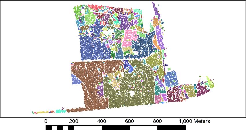
JMIR PUBLIC HEALTH AND SURVEILLANCE Gibson & Rush
such as isolation and quarantine, social distancing, and Given the nature of informal settlements, if social distancing is
community containment become vital in preventing the implemented by the state, it should be established whether an
person-to-person spread of disease by separating people to individual urban settlement is able to achieve this based on the
interrupt transmission [2]. COVID-19 statistics for South Africa layout of the particular settlement. Due to the density of
show that, as of March 30, 2020, there were 1326 cases in South dwellings in informal settlements, effectively implementing
Africa with 324 reported cases in the Western Cape Province social distancing may be a challenge. The objective of this paper
with a total of 3 deaths in the country [3]. In response to the is to determine if social distancing measures are achievable in
COVID-19 pandemic, President Cyril Ramaphosa announced informal settlements in Cape Town using two settlements as an
a nationwide lockdown for 21 days effective at midnight on example. First, we examined the distance between dwellings
March 26, 2020 [4]. This paper was first published online prior and their first, second, and third nearest neighbors. Second, we
to this announcement; however, the method and results can be identified clusters of dwellings in which residents would be
interpreted in light of the lockdown decision and can be used unable to effectively practice social isolation due to the close
to guide any easing of restrictions going forward. proximity of their homes. It should be noted that this study is
based solely on one data set (the outline of informal dwellings),
The challenges faced by the developing world during the
and it is envisaged that public health scientists could incorporate
pandemic are compounded by the presence of informal
this data set as one of many parameters in specific risk
settlements, which are typified by being densely populated and
modelling, should it prove useful. Vulnerability mapping of
lacking formalized sanitation infrastructure [5]. Cape Town,
COVID-19 in the South African context, which considers factors
the capital city of the Western Cape Province with an estimated
other than distances between dwellings, has been written for
population of 4 million, is South Africa’s second most populous
the Gauteng Province [11] and could similarly be applied
city after Johannesburg and Africa’s 10th most populous city
elsewhere in South Africa.
[6]. Cape Town has not been immune to the rise of urbanization,
and migration to the city has led to the establishment of many
informal settlements. Housing in informal settlements is
Methods
unregulated by the state, planned by local communities, and This paper looks at the feasibility of social distancing in two
typically constructed in a haphazard fashion using cheap and informal settlements in Cape Town as an effective measure to
recycled building materials. Due to competition for space, homes prevent transmission of COVID-19 in these urban environments.
can be built close together with only narrow access paths. Some In particular, it looks at the layout of the settlements with respect
settlements are less densely constructed, but these tend to be to the distance between dwellings and their nearest neighbors
the newer settlements located further away from the city in to determine if a social distancing approach is feasible in these
locations where there is little economic opportunity. There are environments. The assumption was made that all outer
an estimated 146,000 households living in informal settlements boundaries of a dwelling are a potential zone of transmission.
in Cape Town, many of which are not recognized as permanent, It is likely that the risk of transmission will be higher at openings
with the residents lacking occupation rights and security of such as doors and windows; however, in the absence of these
tenure [7]. It is further estimated that only one-third of the toilets data, all boundaries of a dwelling were treated equally.
in Cape Town’s informal settlements are permanent
infrastructure with the rest being temporary toilets that are Two informal settlements in Cape Town have been selected to
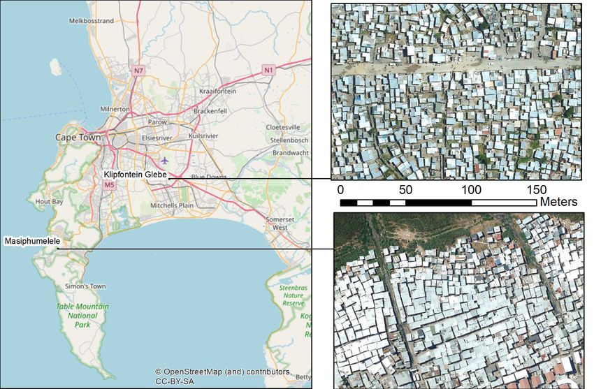
provided and cleaned by private companies [7]. Other challenges demonstrate the application. The location of these two
include the particularly high HIV burden borne by residents of settlements and zoomed in aerial photography of typical areas
informal settlements in comparison to other settlement types within the settlements are shown in Figure 1. It has been widely
[8]. Although there is no evidence that the risk of infection or reported that settlements are typically overpopulated with a high
complications of COVID-19 are different amongst people living dwelling density, but quantitative data on this has been lacking
with HIV when compared with the general population, people until now. Roof outlines of all informal dwellings in informal
living with advanced HIV disease and who are not taking settlements in the city of Cape Town have been mapped from
antiretroviral treatment are at an increased risk of infections, in aerial photography captured in February 2018 [12] and can be
general [9]. used to obtain data on the distance between a dwelling and the
nearest neighbors.
Social distancing aims to reduce the interactions between people
in a broader community and is useful for communities where The dwelling outlines are in the form of a geographic
individuals may be infectious but have not yet been identified information system (GIS) vector data set (shapefile), with
and are thus not isolated [2]. Furthermore, it has been proposed individual polygons representing either individual dwellings
that social distancing be implemented in a rationally layered or, in cases where dwellings are built so close to each other that
manner to protect individuals with a higher risk of mortality they cannot be visually separated, clusters of connected
[10]. Should social distancing measures not be effective, the dwellings. Working within the GIS software ArcGIS 10.5.1
next stage, known as community containment, may need to be (Esri), dwellings corresponding to each settlement were selected
implemented. This involves reduction of personal interaction and saved into separate shapefiles. The proximity tool “Generate
at the community level, which is ethically more challenging, Near Table” was then used to calculate the distance to each
and its implementation requires close partnership and dwelling’s first, second, and third nearest neighbors.
cooperation with law enforcement [2]. Subsequently, in Microsoft Excel, the normalized distribution
of these distances was calculated for the first, second, and third
http://publichealth.jmir.org/2020/2/e18844/ JMIR Public Health Surveill 2020 | vol. 6 | iss. 2 | e18844 | p. 2
(page number not for citation purposes)
XSL• FO
RenderX
JMIR PUBLIC HEALTH AND SURVEILLANCE                                                                                                  Gibson & Rush

     nearest neighbor in each settlement to provide an overview of           home and may either spread or become infected by the virus).
     the density of each settlement in relation to social distance           This would be exacerbated if more than one person in a cluster
     measures.                                                               was outside their home at the same time. Taking the dwellings’
                                                                             outline data set in ArcGIS 10.5.1, the proximity tool “Buffer”
     The UK guidelines on social distancing state that if a person
                                                                             was used to expand the outline of individual dwellings by 1 m.
     meets another while outdoors, they should ensure a 2-m distance
                                                                             Thus, if two dwellings are within 2 m of each other, their buffers
     between them [13]. If such a measure was to be implemented
                                                                             intersect and a single polygon grouping of these dwellings is
     in Cape Town, using the dwelling data set, it is possible to
                                                                             drawn. This is illustrated in Figure 2 where each color represents
     identify clusters of homes that are unable to effectively
                                                                             the groupings of dwellings that would have to self-isolate
     self-isolate due to their proximity to neighbors (ie, a person who
                                                                             together, as individual self-isolation would likely be ineffective.
     leaves their home will immediately be within 2 m of another
     Figure 1. City of Cape Town and the location of Masiphumelele and Klipfontein Glebe.

     http://publichealth.jmir.org/2020/2/e18844/                                                JMIR Public Health Surveill 2020 | vol. 6 | iss. 2 | e18844 | p. 3
                                                                                                                     (page number not for citation purposes)
XSL• FO
RenderX
JMIR PUBLIC HEALTH AND SURVEILLANCE Gibson & Rush
Figure 2. Illustration of how self-isolating clusters of dwellings are identified.
noted that where two or more dwellings’ roofs touched, the
Results cluster of dwelling was digitized as a single dwelling; in reality,
Calculating the distance between each dwelling and its first, the graphs would be slightly skewed to the left (enhanced
second, and third nearest neighbors allows for a better positive skew).
understanding of density and separation distances within In Figure 3 it can be seen that Masiphumelele is a denser
individual settlements. Examining the normalized distribution settlement than Klipfontein Glebe (Figure 4) with homes being
(Figures 3 and 4) can give an indication of the likelihood of a built close together. The distance to the first nearest neighbor
value on the x-axis occurring. The results show that the in Masiphumelele peaks atJMIR PUBLIC HEALTH AND SURVEILLANCE Gibson & Rush
Figure 4. Normalized distribution of the distance between dwellings and their first, second, and third nearest neighbors in Klipfontein Glebe.
The results of buffering the dwelling outlines by 1 m are shown For Klipfontein Glebe (Figure 6), the picture is more varied.
for Masiphumelele (Figure 5) and Klipfontein Glebe (Figure There are some large clusters (for example, the bottom center
6). It can clearly be seen that Masiphumelele poses a high risk olive green cluster) that represent a high transmission risk, but
for COVID-19 spread, as the groups of dwellings that would there are also smaller clusters throughout the settlement where
have to self-isolate together are typically large. The canals in the residents of these homes would be able to self-isolate with
Masiphumelele are effectively acting as breaks between a smaller neighborhood.
dwellings, preventing even larger clusters.
Figure 5. Clusters of dwellings in Masiphumelele that would need to self-isolate together. Different colors indicate group of dwellings that will be
unable to practice social distancing from neighbors within the same color cluster.
http://publichealth.jmir.org/2020/2/e18844/ JMIR Public Health Surveill 2020 | vol. 6 | iss. 2 | e18844 | p. 5
(page number not for citation purposes)
XSL• FO
RenderXJMIR PUBLIC HEALTH AND SURVEILLANCE Gibson & Rush
Figure 6. The clusters of dwellings in Klipfontein Glebe that would need to self-isolate together. Different colors indicate group of dwellings that will
be unable to practice social distancing from neighbors within the same color cluster.
Descriptive statistics of the size of the clusters for Masiphumelele posed a higher risk with respect to the nearest
Masiphumelele and Klipfontein Glebe (Table 1) show that the neighbors than Klipfontein Glebe; however, the box and whisker
largest cluster occurred in Klipfontein Glebe; however, the mean chart in Figure 7 together with the descriptive statistics (Table
value for Masiphumelele exceeded that of Klipfontein Glebe. 1) appear to paint a somewhat different picture. Klipfontein
The number of people living in these clusters is unknown, and Glebe has the larger maximum cluster size and the larger median
it is unlikely that data at this level exists; however, a count of with a smaller standard deviation. However, the presence of
the dwellings is possible, and extrapolations about the estimated some large clusters within the Masiphumelele data set, together
number of people per household can be made. The normalized with the lower count, result in a higher mean in Masiphumelele.
distribution graphs (Figures 3 and 4) seem to show that
Table 1. Descriptive statistics of the size (m2) of clusters in Klipfontein Glebe and Masiphumelele.
Statistics Klipfontein Glebe clusters Masiphumelele clusters
Mean, m2 581 2432
Standard error, m2 164 1156
Median, m2 60 42
Standard deviation, m2 3999 7124
Minimum, m2 20 24
Maximum, m2 67312 30350
Number of clusters, n 593 38
http://publichealth.jmir.org/2020/2/e18844/ JMIR Public Health Surveill 2020 | vol. 6 | iss. 2 | e18844 | p. 6
(page number not for citation purposes)
XSL• FO
RenderXJMIR PUBLIC HEALTH AND SURVEILLANCE Gibson & Rush
Figure 7. Box and whisker chart of size of clusters in Klipfontein Glebe and Masiphumelele. Note the log scale on the y-axis.
Limitations
Discussion
A known limitation to this method is that many residents have
Principal Results to walk to a water stand and toilet, as many of the informal
The results imply that social distancing (short of a lockdown) settlements are not serviced at the dwelling level. This creates
would be difficult to achieve in the two selected settlements. unavoidable movement of people, and the pathways taken from
To effectively maintain social distancing, residents would, in dwellings to these communal points will be frequently used.
effect, be unable to leave their homes. This is impractical, given Furthermore, these communal points will themselves be
that many homes are not serviced and lack toilets and running locations for potential disease spread, and, much like John
water. Even in the case of a complete lockdown (as is currently Snow’s original research on epidemiology in 1854 [14], actions
underway), residents would be asked to do the impossible, as to prevent disease spread at these locations should be taken
they would be unable to leave their homes to access toilets and (although different from those implemented by Snow). Analysis
water while maintaining a safe 2-m separation distance. In of these data, if they indeed exist, should occur in parallel and
addition, the living conditions inside homes are generally in combination with the work presented here. Furthermore, it
cramped and overcrowded with inadequate insulation, making is reiterated that this method alone does not represent the entire
staying indoors unbearably uncomfortable, particularly on hot picture of vulnerability to COVID-19 transmission in Cape
days. Given the results of this paper, when implementing Town informal settlements.
lockdowns, the authorities may need to take a more nuanced Comparison to Prior Work
approach and consider implementing shut down at the
Similar work has not been found in the literature. Where
community level, rather than at the household level.
vulnerability to COVID-19 or other disease has been mapped,
The principal finding of this research is that, in the selected it tends to consider data such as census data to identify density
settlements, distance to each dwelling’s first 3 nearest neighbors of populations, poverty indicators, and proportion of the
illustrated that the settlement of Masiphumelele is constructed population that fall in the vulnerable category [11]. Other uses
in a denser fashion when compared with the Klipfontein Glebe of GIS in the COVID-19 pandemic has been widespread, mostly
settlement, which, although some portions of the settlement are showing the location and magnitude of caseload or fatalities (a
dense, is generally more dispersed. The first, second, and third list is available on the website of the Center for Infectious
nearest neighbors peak at approximately 0.5 m, 1.0 m, and 1.5 Disease Research and Policy [15]).
m, respectively, for Masiphumelele, and approximately 0.7 m,
1.4 m, and 2 m, respectively, for Klipfontein Glebe. This implies Conclusions
that implementing social distancing will likely be more If the assumption presented earlier in the paper holds true, then
challenging in Masiphumelele than in Klipfontein Glebe. effectively implementing social distancing in informal
However, using a 2-m social distancing measure, it was settlements in Cape Town will present a challenge. However,
demonstrated that large portions of Klipfontein Glebe would community containment poses its own challenges. Thus,
also be unable to effectively implement social distancing. containment of the spread of COVID-19 in Cape Town to
prevent it reaching the informal settlements is likely to be a key
consideration for authorities and decision makers. This will
http://publichealth.jmir.org/2020/2/e18844/ JMIR Public Health Surveill 2020 | vol. 6 | iss. 2 | e18844 | p. 7
(page number not for citation purposes)
XSL• FO
RenderXJMIR PUBLIC HEALTH AND SURVEILLANCE Gibson & Rush
hold true for many other cities within Africa and the developing decision makers, a mobilization of volunteer GISs as well as a
world, in general. However, data on informal settlements at the machine learning approach would be proposed to produce the
level that has been presented here is lacking in most, if not all, data required in the shortest a time period possible.
cities. Should the method presented here be deemed useful to
Conflicts of Interest
None declared.
References
1. Ducharme J. Time. 2020 Mar 11. World Health Organization Declares COVID-19 a 'Pandemic.' Here's What That Means
URL: https://time.com/5791661/who-coronavirus-pandemic-declaration/ [accessed 2020-03-23]
2. Wilder-Smith A, Freedman DO. Isolation, quarantine, social distancing and community containment: pivotal role for
old-style public health measures in the novel coronavirus (2019-nCoV) outbreak. J Travel Med 2020 Mar 13;27(2). [doi:
10.1093/jtm/taaa020] [Medline: 32052841]
3. COVID-19 SouthAfrica. COVID-19 South Africa Dashboard URL: https://datastudio.google.com/u/0/reporting/
15817068-62f2-4101-8e0f-385e2ddd9326/page/wI9JB [accessed 2020-03-31]
4. South African Government. 2020 Mar 23. President Cyril Ramaphosa: Escalation of measures to combat Coronavirus
COVID-19 pandemic URL: https://www.gov.za/speeches/
president-cyril-ramaphosa-escalation-measures-combat-coronavirus-covid-19-pandemic-23-mar [accessed 2020-03-27]
5. Wilkinson A. Institute of Development Studies. 2020 Mar 10. The impact of COVID-19 in informal settlements - are we
paying enough attention? URL: https://www.ids.ac.uk/opinions/
the-impact-of-covid-19-in-informal-settlements-are-we-paying-enough-attention/ [accessed 2020-03-27]
6. City of Cape Town. Integrated annual report 2016/17 URL: https://resource.capetown.gov.za/documentcentre/Documents/
City%20research%20reports%20and%20review/Annual%20Report%202016_17.pdf [accessed 2020-03-27]
7. Ismaps.org. Struggle for dignity in cape town's informal settlements: the facts URL: http://ismaps.org.za/desktop.html
[accessed 2020-03-27]
8. Gibbs A, Reddy T, Dunkle K, Jewkes R. HIV-Prevalence in South Africa by settlement type: a repeat population-based
cross-sectional analysis of men and women. PLoS One 2020 Mar 17;15(3):e0230105 [FREE Full text] [doi:
10.1371/journal.pone.0230105] [Medline: 32182255]
9. World Health Organization. 2020 Mar 24. Q&A on COVID-19, HIV and antiretrovirals URL: https://www.who.int/
news-room/q-a-detail/q-a-on-covid-19-hiv-and-antiretrovirals [accessed 2020-03-27]
10. Stein R. COVID-19 and rationally layered social distancing. Int J Clin Pract 2020 Mar 14:e13501. [doi: 10.1111/ijcp.13501]
[Medline: 32170898]
11. de Kadt J, Götz G, Hamann C, Maree G, Parker A. Gauteng City-Region Observatory. 2020 Mar 20. Mapping vulnerability
to COVID-19 in Gauteng URL: https://www.gcro.ac.za/outputs/map-of-the-month/detail/mapping-vulnerability-to-covid-19/
[accessed 2020-03-28]
12. School of Engineering. Dwelling outline - informal settlements of Cape Town. University of Edinburgh 2020 Jan 28. [doi:
10.7488/ds/2758]
13. Public Health England. Guidance on social distancing for everyone in the UK URL: https://www.gov.uk/government/
publications/covid-19-guidance-on-social-distancing-and-for-vulnerable-people/
guidance-on-social-distancing-for-everyone-in-the-uk-and-protecting-older-people-and-vulnerable-adults [accessed
2020-03-23]
14. Paneth N. Assessing the contributions of John Snow to epidemiology: 150 years after removal of the broad street pump
handle. Epidemiology 2004 Sep;15(5):514-516. [doi: 10.1097/01.ede.0000135915.94799.00] [Medline: 15308944]
15. Center for Infectious Disease Research and Policy. COVID-19 maps & visuals URL: http://www.cidrap.umn.edu/covid-19/
maps-visuals [accessed 2020-03-28]
Abbreviations
COVID-19: coronavirus disease
GIS: geographic information system
WHO: World Health Organization
http://publichealth.jmir.org/2020/2/e18844/ JMIR Public Health Surveill 2020 | vol. 6 | iss. 2 | e18844 | p. 8
(page number not for citation purposes)
XSL• FO
RenderXJMIR PUBLIC HEALTH AND SURVEILLANCE Gibson & Rush
Edited by G Eysenbach, T Sanchez; submitted 23.03.20; peer-reviewed by L Cheong, E Da Silva; comments to author 26.03.20; revised
version received 31.03.20; accepted 01.04.20; published 06.04.20
Please cite as:
Gibson L, Rush D
Novel Coronavirus in Cape Town Informal Settlements: Feasibility of Using Informal Dwelling Outlines to Identify High Risk Areas
for COVID-19 Transmission From A Social Distancing Perspective
JMIR Public Health Surveill 2020;6(2):e18844
URL: http://publichealth.jmir.org/2020/2/e18844/
doi: 10.2196/18844
PMID:
©Lesley Gibson, David Rush. Originally published in JMIR Public Health and Surveillance (http://publichealth.jmir.org),
06.04.2020. This is an open-access article distributed under the terms of the Creative Commons Attribution License
(https://creativecommons.org/licenses/by/4.0/), which permits unrestricted use, distribution, and reproduction in any medium,
provided the original work, first published in JMIR Public Health and Surveillance, is properly cited. The complete bibliographic
information, a link to the original publication on http://publichealth.jmir.org, as well as this copyright and license information
must be included.
http://publichealth.jmir.org/2020/2/e18844/ JMIR Public Health Surveill 2020 | vol. 6 | iss. 2 | e18844 | p. 9
(page number not for citation purposes)
XSL• FO
RenderXYou can also read