Oso Mudslide Closure of SR 530 - March 22, 2014
←
→
Page content transcription
If your browser does not render page correctly, please read the page content below
Oso Mudslide
         Closure of SR 530
            March 22, 2014
                Stillaguamish Tribe
NW Region Tribal Transportation and BIA Symposium
                  March 18, 2015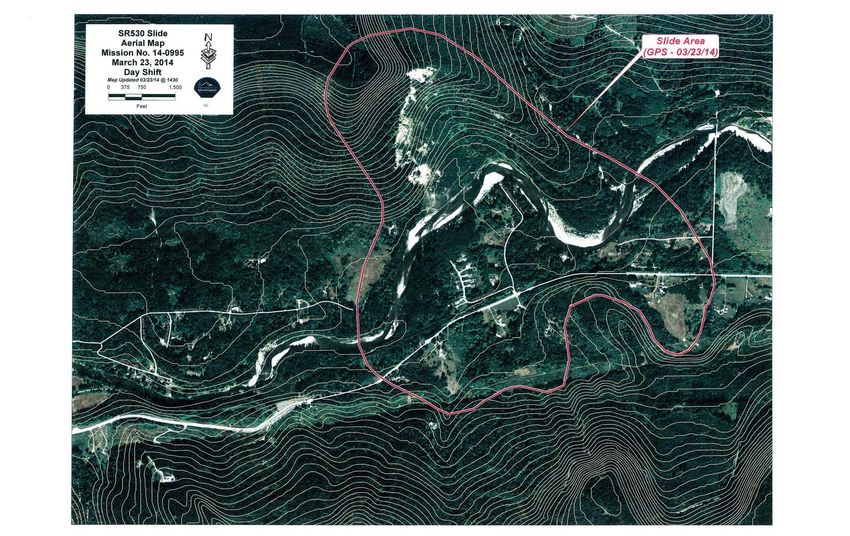
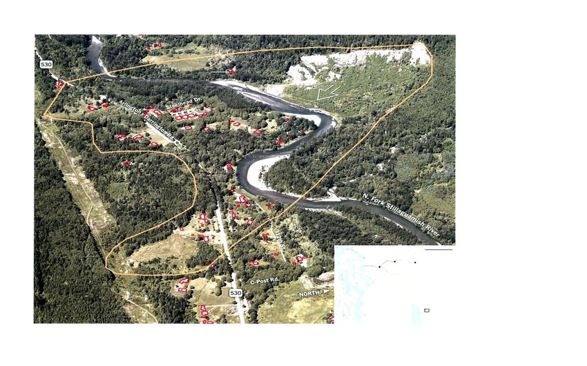
Relevance to the Stillaguamish Tribe
Stillaguamish Tribal properties are in blue

                         Oso Mudslide

                                        Approx. 12 Miles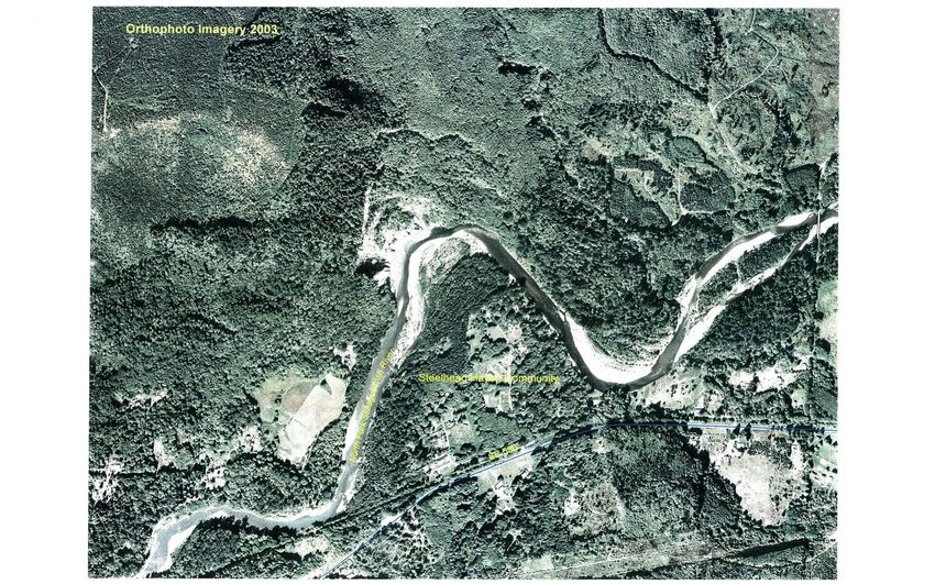
Stillaguamish Tribal IRR Inventory 2013
Coey Gilleland of the Tribe and Red Plains do the Inventory Work

         Oso Mudslide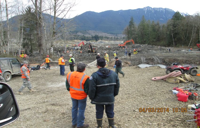
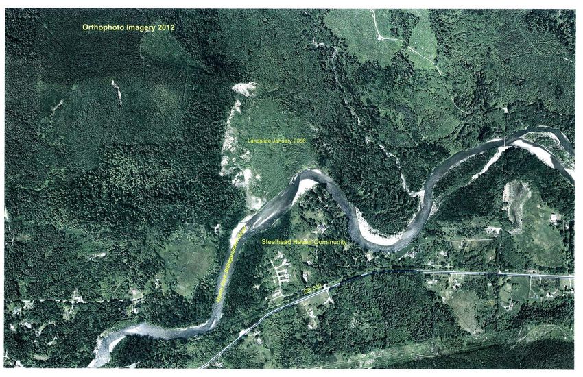
Steelhead Drive Mudslide Area 2003

                                     C Post
                                     Road

         SR 530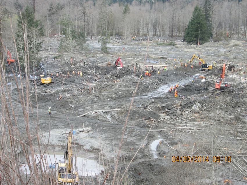
Steelhead Drive 2012
 2006 Landslide
2014 Oso Mudslide
2003 2014
General Information Oso Mudslide

• Oso Mudslide occurred Saturday, March 22, 2014 at
  10:37 AM
• Approximately 10 million cubic yards of mud slid down
  and across the Stillaguamish River
• Approximately 1 square mile of land was covered closing
  SR 530
• SR 530 normally had 3,400 ADT
• Fear of the mudslide continuing and severe flooding
  downriver. Evacuations take place.
• The river backed up for approximately one mile until a
  new channel started on its own
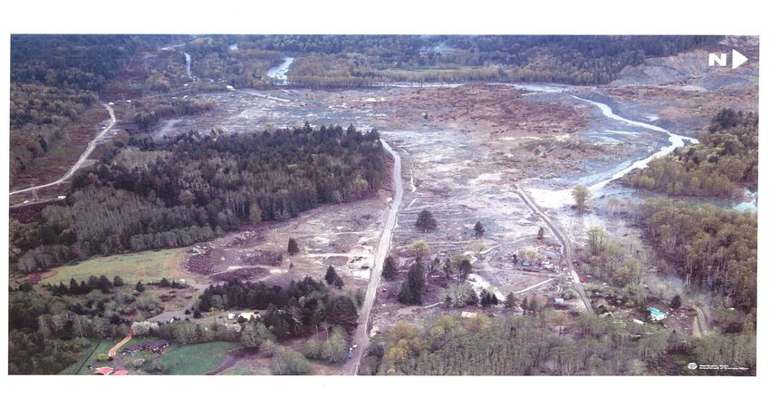
Flood Waters Back-Up to the East (Top Left)
                 SR 530

                                          North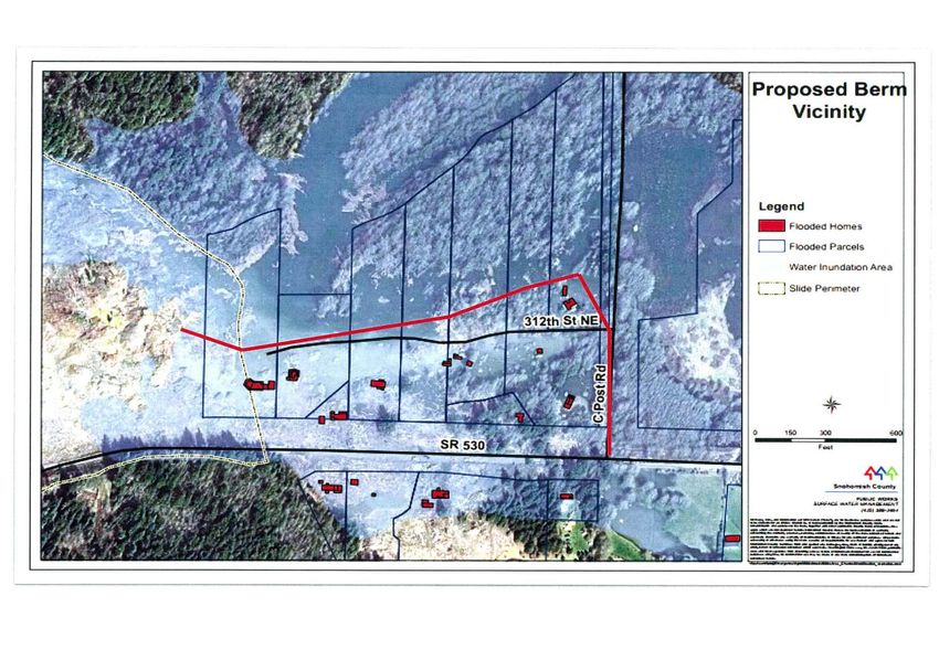
Mudslide Delineation
Generated the Day after the Mudslide
Floodwaters – Housing - Berm
Rescue and Recovery

• Few emergency people on the mudslide itself during
  initial 36 hours
• Rescue people ramped up efforts on the mudslide
  after initial fears subsided
• Immediately, 100-150 people were believed to be
  missing
• Approximately 1 mile of SR 530 was covered and or
  destroyed.
• Local mobilization within hours - regional
  mobilization within a few days. About 700 people
  were working the site by the 3rd or 4th day.
Rescue and Recovery 12 days after the Mudslide
              (From the Southwest Corner)

SR 530
                                               North
West Side
SR 530 on the East Side
Full Mudslide Face
Housing Locations Before

                North
Housing Locations After
Emergency Access Dewatering Berm
Road
SR 530
NorthSR 530 - Before
EastSR 530 - After (from the same location)
Affected People

• 43 people are deceased. All were found.
• A few Stillaguamish families with Sauk-
  Suiattle/Darrington relatives were affected
• All of the Sauk-Suiattle Tribe affected. (340 enrolled
  members)
• Approximately 20 Stillaguamish employees impacted.
• Arlington to Darrington drive went from a ½ hour to
  over 2 hours each way. Fuel expenses more than
  doubled.
• Many people sought alternate accommodation
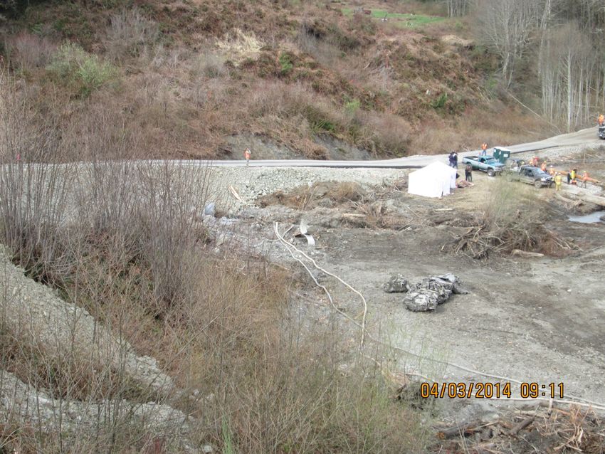
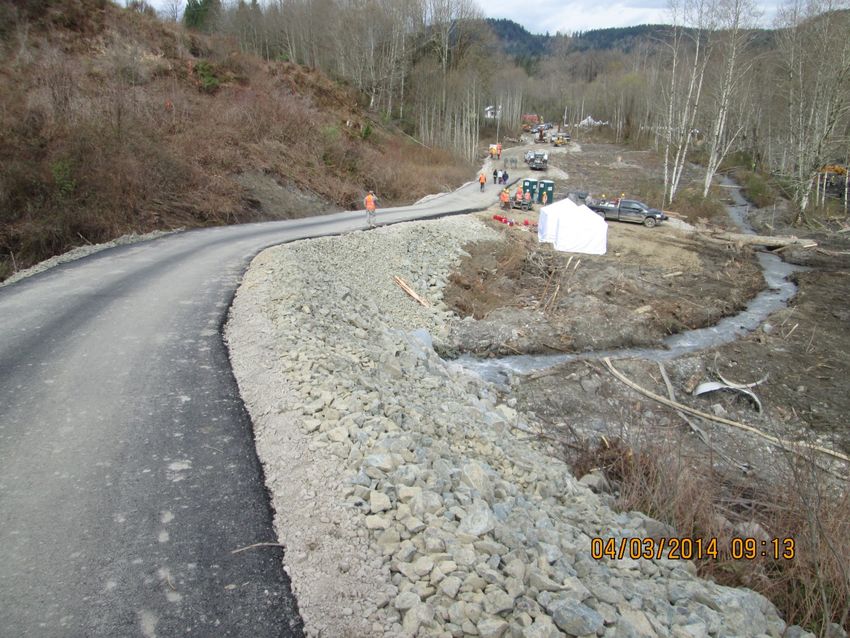
Emergency Access Road

• A 1.8 mile emergency access road was
  immediately identified along Seattle City Light
  power lines.
• It was “improved” for trucks and emergency
  equipment within 1 week of the mudslide.
Emergency Access Road

Emergency
Access Road
Emergency Access Road
1,400 foot gap in the road. Gap filled in 20 continuous working hours.
Approx. 10 – 12,000 CY of material. Steep grade (18%) is asphalt.
Emergency Access Road
Two teams meet at the creek
Emergency Access Road
Portions of SR 530 were found along base of the hill
Emergency Access Road/WSDOT

• Emergency vehicles only for one month
• Public desperate for alternate route because
  the detour added hours of daily travel time
• Community meetings
• “Who is going to unbury my property?”
Emergency Access Road
Mostly improved by locals with logging background, no plans, turnouts built for sight
                                distance throughout
Emergency Access Road Opens to the Public • Before the public could use the Emergency Access Road - One Party held out, word spread, problem resolved • Road opened to local public only
Community Transit
(10 passengers per day in the first week of operation)
Could the Stillaguamish Tribe Contribute to the
                Recovery Effort?
        Indian Reservation Road Inventory - 2013
          Oso Mudslide
Possible Funding Sources to Help Contribute to the Recovery
Tribal High Priority Projects Program (HPP Program)HPP Program • Matt Bohmert – Rick Larson’s office. They didn’t know what IRR or HPP was at first. They said they were in close contact with Patty Murray’s office with the Mudslide disaster. • Sally Hintz in Maria Cantwell’s office “call Mary Pavel”. • Mary Pavel – Staff Director of US Senate Committee on Indian Affairs holds a conference call with her staff and the Stillaguamish Tribe. “HPP exists but it’s not funded and won’t be until the fall, if at all. You could use your IRR allocation.”
Emergency Relief for Federally Owned Roads
                  (ERFO)
ERFO • ERFO – Emergency Relief for Federally Owned Roads – • 1st Communication with Dave Hilgendorf, Western Federal Lands, FHWA - “SR 530 is a State Route and on the National Tribal Transportation Inventory (AKA - IRR Inventory). We will look into this and get back to you.” • Kyle Kitchel – FHWA calls later. “Because SR 530 is on the IRR Inventory, ER will pay for 100% of the ER funded portion of the rebuilding project.” • Dave Hilgendorf, later communication – “The 100% funding from FHWA (not the 86.5% as originally thought) is not a waiver, a discretionary issue or a gift, it’s a regulation.”
SR 530 Reconstruction Schedule
               (All dates and costs subject to change)

ER Funds
$3.4 mil
                          (Removal of approx. 100,000
FEMA Funds
                          cys of mud and debris)
$4.9 mil

ER Funds
$20.57 mil
• Main Point – Because SR 530 is on the IRR Inventory, FHWA (Emergency Relief) will pay 100% amount of the emergency access road and the rebuilding cost (not the normal 86.5%) • State and Local agencies will not have to pay the 13.5% cash match (or about $3.23 million) • FEMA pays for the debris removal
Side Issues

• One victim worked on creating “Freedom
  County” by separating from Snohomish
  County
• Some were saying “there are too many land
  use regulations in Snohomish County”. Went
  through the initiative process. Did not pass.
• YET, there are several Mudslide law suits
  charging Snohomish County/Washington State
  for not protecting people from dangers
Rebuilt SR 530
(Abandoned SR 530 on the left)

       East
You can also read