Pandemic Minecrafting: an analysis of the perceptions of and lessons learned from a gamified virtual geology field camp - Geoscience Communication
←
→
Page content transcription
If your browser does not render page correctly, please read the page content below
Research article
Geosci. Commun., 4, 475–492, 2021
https://doi.org/10.5194/gc-4-475-2021
© Author(s) 2021. This work is distributed under
the Creative Commons Attribution 4.0 License.

Pandemic Minecrafting: an analysis of the perceptions of and
lessons learned from a gamified virtual geology field camp
Erika Rader1 , Renee Love1 , Darryl Reano2,3 , Tonia A. Dousay4 , and Natasha Wingerter5,6
1 Department  of Geography and Geological Sciences, University of Idaho, Moscow, 83843, USA
2 STEM   Transformation Institute, Florida International University, Miami, 33199, USA
3 School of Earth and Space Exploration, Arizona State University, Tempe, 85281, USA
4 College of Education, University of Idaho, Moscow, 83843, USA
5 Water Resources Program, University of Idaho, Moscow, 83843, USA
6 Red Bluff Fish and Wildlife Office, U.S. Fish and Wildlife Service, Red Bluff, 96080, USA

Correspondence: Tonia A. Dousay (tonia@uidaho.edu)

Received: 13 May 2021 – Discussion started: 2 June 2021
Revised: 30 August 2021 – Accepted: 5 September 2021 – Published: 19 October 2021

Abstract. To mimic the 3D geospatial components of ge-           curricular goals and was relatively easy to construct, we rec-
ologic mapping usually spotlighted by field camp, we de-         ommend the usage of Minecraft for virtual geology courses
veloped a virtual course based in the sandbox video game         in the future.
Minecraft. Paired with audio/video conferencing and real
data, students practiced measuring strike and dip, orienteer-
ing with a compass, matching landscape features with topo-       1   Introduction
graphic maps, and tracing geologic contacts within the team
structure typically employed in field camp. Open-source pro-     A critical component of nearly all geoscience work is a thor-
grams and tutorials freely available online assisted with con-   ough grasp of spatial concepts (e.g., Black, 2005; Liben and
structing the Minecraft worlds. Assignments were aligned         Titus, 2012; Orion et al., 1997). The ability to orient one-
to the nine learning outcomes established for geology field      self in a landscape, track landforms across great distances,
camps by the National Association of Geology Teachers            and project complex shapes into the subsurface is a skill
(NAGT). A pre-survey and post-survey quantified students’        many students struggle with initially (e.g., Montello, 2001;
learning of the subject matter as well as perceptions to-        Sorby, 2001; Titus and Horsman, 2009). In many geoscience
wards Minecraft and online learning. We also held feedback       programs, the capstone “field camp” course immerses stu-
sessions and conducted in-class, live observations to clas-      dents in landscapes with their classmates and has been con-
sify students’ reactions and experiences during virtual activ-   sidered the gold standard for producing field-ready geosci-
ities. Overwhelmingly, students indicated they would have        entists. Field studies serve as an essential component of
preferred an in-person field camp, yet they considered the       scientific curriculum (Fleischner et al., 2017; Lambert and
Minecraft assignments exciting, important, interesting, and      Reiss, 2014). However, what happens when programs sud-
valuable. Regardless of perceived barriers, scores on sub-       denly lose access to such experiences as occurred because
ject matter questions increased from the pre- to the post-       of the COVID-19 pandemic in the summer of 2020? Some
survey. Finally, observations illustrated how students’ expe-    virtual environments, including ours, were developed or aug-
riences in a virtual field camp recreated comparable compo-      mented during the spring of 2020 (Parcell and Parcell, 2020;
nents that students experience during an in-person field camp    Bursztyn et al., 2021; Gregory et al., 2021; Whitmeyer and
(e.g., students discussing career pathways, geological skills,   Dordevic, 2021).
and fostering interpersonal relationships). Because this vir-       Virtual and augmented realities allow educators to simu-
tual course achieved the curricular goals as well as the non-    late spatial relationships in a scientific context (e.g., Camp-
                                                                 bell et al., 2002; Elgner et al., 2017; Minocha et al., 2018;

Published by Copernicus Publications on behalf of the European Geosciences Union.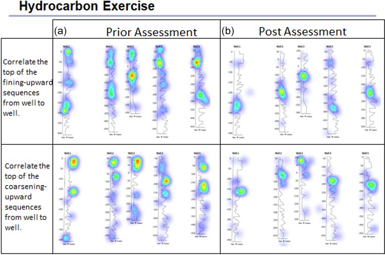
476                                                                                      E. Rader et al.: Pandemic Minecrafting

Moore et al., 1999; Poland et al., 2003; Zhao et al., 2018).         1. Design a field strategy to collect or select data in order
In some cases, a virtual rendering of a field site is the only          to answer a geologic question.
feasible way to explore the area of interest, such as in plan-
etary and oceanographic research (e.g., Anandapadmana-               2. Collect accurate and sufficient data on field relation-
ban et al., 2018; Barnes et al., 2018; Elgner et al., 2017;             ships and record these using disciplinary conventions
Hodges and Schmitt, 2019; Ortner et al., 2018; Vitacion and             (field notes, map symbols, etc.).
Liu, 2019).                                                          3. Synthesize geologic data and integrate with core con-
   Minecraft, in particular, has the potential to help teach stu-       cepts and skills into a cohesive spatial and temporal sci-
dents a range of scientific and other academic concepts, some           entific interpretation.
of which may require the manipulation of a spatial dataset.
Minecraft can be used to stimulate interest in geology and           4. Interpret earth systems and past, current, and future pro-
geography among elementary learners, because it incorpo-                cesses using multiple lines of spatially distributed evi-
rates rich visual simulations (Iwahashi et al., 2019). In addi-         dence.
tion, mini-games and activities for elementary and secondary
learners can integrate all the sciences well, through modeling       5. Develop an argument that is consistent with available
the earth’s surface to support geology and geography visual-            evidence and uncertainty.
ization of science concepts (Nebel et al., 2016; Short, 2012).       6. Communicate clearly using written, verbal, and/or vi-
   Similar examples include using Minecraft with upper el-              sual media (e.g., maps, cross-sections, reports) with
ementary/middle school learners to teach spatial awareness              discipline-specific terminology appropriate to your au-
and illustrate interactions between humans and their envi-              dience.
ronment (Scarlett, 2015) or to develop landscape awareness
(Sahin and Ozgur, 2016). Formosa (2014) illustrated how              7. Work effectively, independently, and collaboratively
recreating cities in Minecraft aids with familiarization prior          (e.g., commitment, reliability, leadership, open for ad-
to traveling. Riordan and Scarf (2016) explored how to use              vice, channels of communication, supportive, inclu-
Minecraft to support social interaction and foster collabora-           sive).
tion. Building on the success of these previous applications
of Minecraft, Clemenson et al. (2019) investigated memory            8. Reflect on personal strengths and challenges (e.g., in
improvement when experiencing rich learning experiences in              study design, safety, time management, independent
Minecraft, noting specific benefits to hippocampal memory               and collaborative work).
with implications for enhanced retrieval of information.             9. Demonstrate behaviors expected of professional geosci-
   One of the Minecraft platform’s strengths is the high de-            entists (e.g., time management, work preparation, colle-
gree of customization of various geologic elements, such as             giality, health and safety, ethics).
rock type, rock texture, and tools like compasses or maps
(Fig. 1). These capabilities give users the freedom to dig             The virtual field camp (VFC) included assessments
into the subsurface and explore realistic 3D structures from        aligned to the NAGT outcomes and measured academic ef-
the inside, which can aid student learning. An extensive on-        fectiveness. Additionally, we strove to mimic positive ex-
line community of Minecraft users (“Minecrafters”) provides         periences of in-person field camp, strategically selecting
ample resources, tutorials, and open-source code, which the         complementary technologies and assignments to supplement
authors utilized to support their novice experience with the        Minecraft-based assignments. The nine NAGT outcomes
game.                                                               formed the practical framework for an integrated evaluation
   Previous research studies focused on the benefits of us-         of the project and the following primary research question.
ing Minecraft as a teaching tool have centered on elemen-           How do students perceive engagement and skill development
tary and secondary learners. Post-secondary applications of         in a virtual field experience? Connectivism provided a theo-
Minecraft that are documented in discipline-based educa-            retical framework to design and study this innovative learn-
tional research in the geosciences are scarce. Faced with the       ing experience.
challenge of no access to traditional field experiences, the           A team of seven STEM educators and researchers facili-
current project drew upon previous recommendations for de-          tated this project. Two geoscience instructors co-taught the
signing and studying a virtual field experience that incorpo-       field experience, designing and implementing all lessons and
rated the use of Minecraft. To ensure that the designed vir-        activities with the assistance of two teaching assistants. Three
tual field camp had the same educational outcome as tradi-          education researchers collected and analyzed related data.
tional (i.e., in-person) field camps, the National Association         We had a sample set of 24 enrolled students; 66 % stu-
of Geoscience Teachers (NAGT) put out a set of nine recom-          dents were working, all were between the ages of 20 and
mended learning outcomes:                                           35, 19 of the 24 students identified as White, 6 were fe-
                                                                    male, and 18 were male. The field course was scheduled for
                                                                    5 virtual days a week and was facilitated using Zoom and

Geosci. Commun., 4, 475–492, 2021                                                        https://doi.org/10.5194/gc-4-475-2021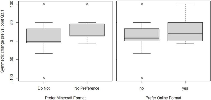
E. Rader et al.: Pandemic Minecrafting                                                                                             477

Figure 1. A composite image with panel (a) showing custom compass (insert a) and angled surfaces for measuring strike and dip as well as
real photos (b) embedded into the game to provide realistic rock and foliation (insert b) identification opportunities.

Blackboard. We began each class with a warm-up exercise               Imago before the class began, and servers were set up to fa-
to identify features on field photos. This also helped make           cilitate the Minecraft worlds.
sure that students came to class on time and allowed us to
take attendance. Class was divided into four segments. (1)            Connectivism
Morning: this consisted of the morning warm-up, a lecture
to introduce key topics and the exercise to be performed,             When viewing learning and work in the 21st century, the con-
and a question-and-answer session to go over material from            nectivism theoretical framework acknowledges that learning
the previous day. (2) Mid-morning: if needed, another lecture         is not solitary, and the ways in which we learn and func-
was presented, but most days students continued on their ex-          tion are influenced by the tools we use. When positing the
ercises that began during the morning session or the previ-           framework, Siemens (2005) argued that behaviorism, cogni-
ous day. This mid-morning check-in allowed the instructors            tivism, and constructivism theories fail to accurately account
to make sure students understood the exercise material and            for the learning environment and its impact on learner agency
were working through it in groups. (3) Afternoon: after an            and related affective effects. From an educator’s standpoint,
hour lunch break, students returned to the Zoom room to get           using an educational environment to enhance learning may
another segment of the exercise, another lecture, or help on          seem obvious. However, attributing a measurement of learn-
the assignment. (4) Evening: instructors and teaching assis-          ing to specific aspects of an educational environment is diffi-
tants were present on Zoom during the evening for virtual             cult, if not impossible, in contemporary, undergraduate class-
office hours as students completed their assignments. Stu-            rooms. To move the theoretical framework forward, Smidt et
dents were given the weekend to complete mapping projects             al. (2017) established a model around connectivism to opera-
if needed. Special licenses were obtained for Leapfrog and            tionalize how we learn (through connectivist strategies), what
                                                                      we learn (through problem-based scenarios), and why we are
                                                                      learning (contextual application). When innovative learning

https://doi.org/10.5194/gc-4-475-2021                                                         Geosci. Commun., 4, 475–492, 2021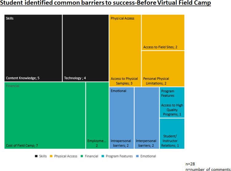
478                                                                                   E. Rader et al.: Pandemic Minecrafting

projects apply the connectivist framework, they anchor the       magnetic compass (Godfirnon et al., 2020). Mods are mod-
learning experience in an active, situated context with au-      ified packages that plug into Minecraft Java Edition via the
thentic elements. For our project, this meant that the edu-      program Forge and allows for customizations in the game.
cation researchers explicitly made connections between the       We then created other custom-built block types with Re-
VFC (i.e., educational environment) and the instructor’s in-     source Pack Workbench and MrCrayfish’s Model Creator
tentional learning objectives (i.e., the NAGT learning out-      (MightyPork, 2018; MrCrayfish, 2020). Custom-built out-
comes), student output (e.g., student work products), and ob-    crops included inclined surfaces for measuring strike and dip
servations of student behavior in group work.                    with Carpenter’s Block (Mineshopper, 2019), which can cre-
   The VFC applied connectivism principles through a se-         ate any strike from 0–359◦ and dips in any direction from
ries of situated lessons and team-based scenarios to support     5–45◦ . Steeper dips required visual patterns to illustrate bed-
a problem-based learning structure. The underlying princi-       ding, banding, or foliation. Figure 1 depicts a composite il-
ples of connectivism include autonomy, diversity, interactiv-    lustration of these custom features.
ity, and openness (Downes, 2020). Autonomy recognizes that          A layer of cover (sand, grass, dirt, etc.) covered the land
students have a right to agency, and criticism of connectivism   so that outcrop exposure could be increased or decreased de-
highlights how students do not always benefit from or take       pending on the participants’ skill level. Adding plants also
advantage of this type of learning freedom. In our project,      mimicked the challenges of mapping in heavily vegetated ar-
these principles helped to guide how we measured the suc-        eas and the benefits when a particular plant corresponds to
cess of the VFC situated lessons and team-based scenarios.       certain geological features. Modifying the magnetic compass
Kop (2011) noticed that students sometimes lack the self-        from BetterGeo with Resource Pack Workbench allowed stu-
regulation strategies necessary to succeed in an otherwise in-   dents to read a SILVA Ranger or a Brunton Pocket Tran-
dependent learning environment that requires design consid-      sit. A pointing mod enabled avatars to point at outcrops or
erations to mitigate isolating aspects.                          structures in the game (MrCrayfish, 2020). We added realis-
   Individual and collaborative activities and assignments in    tic rock faces and “you are here” maps by converting images
the VFC capitalized on affordances and mitigated the chal-       of rock faces and maps using Image Map (Tryashtar, 2020)
lenges experienced with connectivism. For example, activi-       to display in frames around the field site.
ties encouraging play and exploration in Minecraft allowed          Students used the mods and resource packs to experience
students choice and agency to explore, interact, and form in-    different worlds loaded onto a server. For example, a 3D geo-
clusive groups. Further, allowing students the flexibility to    logic model published by the British Geological Survey (En-
customize Minecraft avatar skins provided an outlet for self-    twisle, 2019; Steuer and Thorpe, 2019) contributed to build-
expression. Four exercises placed students into field teams,     ing one of the worlds. We built a small anticline structure
establishing community and expectations for student engage-      with a petroleum play of oil and gas into the West Thurrock
ment, fostering interaction, and supporting autonomy. Stu-       model by placing blocks while in the game. We asked stu-
dents, faculty, and instructional assistants openly communi-     dents to examine potential surface structures to project into
cated using a variety of tools, including a learning manage-     the subsurface, correlate provided geophysical well logs to
ment system (i.e., Blackboard), video conferencing, and text     determine the best target interval and location, and “drill”
messaging.                                                       to test student correlation to find the hydrocarbons. This ac-
                                                                 tivity represents the complex and layered approaches to de-
                                                                 signing activities, ensuring alignment across NAGT learning
2     Curricular design
                                                                 outcomes.
2.1    Turning a geologic map into a mappable Minecraft
       world                                                     2.2   Learning activities

Numerous free, open-source software packages designed for        Each learning activity in the VFC contained multiple exer-
Minecraft Java Edition (designed by Mojang) aided in recre-      cises targeting specific field or industry skills. In addition
ating the geology, topography, and equipment needed for the      to teaching with Minecraft, other technologies assisted with
VFC. The Tangram Heightmapper (Mapzen, 2017) provided            presenting concepts to meet our learning objectives. For ex-
greyscale DEMs of the field locations. Course instructors up-    ample, we designed an industry-focused lesson with multiple
loaded these images into World Painter (Pepsoft, 2020) to        exercises to mimic reconnaissance work that mappers at state
create the base layer of topography, scaling the images so       geological surveys perform before and after visiting a field
that students could see enough of the landscape to use to-       area. Careful design and structuring of lessons mimicked au-
pography to orient themselves. An overlay on the geologic        thenticity and aided with an integrated design.
map in World Painter allowed the instructors to paint geo-          Across lessons and exercises, we divided students into four
logic units over the topography with different block types.      teams for activities, including mapping and analysis. In one
   In-world design began with sourcing initial block types       exercise, students had to work with teams working in adja-
from BetterGeo, a mod containing more types of rocks and a       cent map areas to correlate units and resolve differences. We

Geosci. Commun., 4, 475–492, 2021                                                     https://doi.org/10.5194/gc-4-475-2021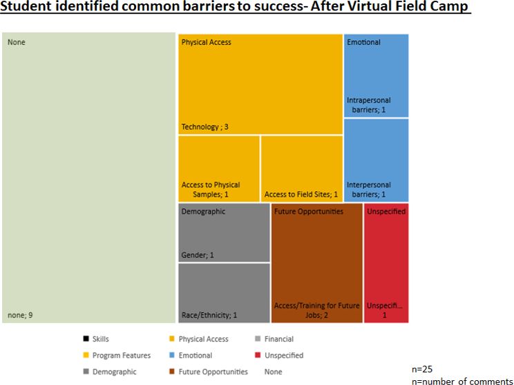
E. Rader et al.: Pandemic Minecrafting 479
extended this exercise by then placing students in a related
Minecraft world with a nearby fold-and-thrust belt to work
with facies mapping and recognizing folds and thrust faults
recognition
in the virtual world. Additionally, these two mapping areas
rock ID
facies
had the same units, providing students with multiple exam-
ples of what the rocks looked like in outcrop when exploring
the Minecraft block textures.
We used Zoom video conferencing to teach each class,
cross-section
cross-section
cross-section
cross-section
using breakout rooms to facilitate group work. Safety and
report
inclusivity are significant components that students should
learn in all field camps. “Safety minutes” were discussed in-
termittently throughout the course to cover potential hazards
Minecraft mine shaft mapping
if they were mapping in the field, ergonomic concerns, and
safety in groups. We also discussed inclusivity in the geo-
map patterns and contacts
sciences (Carabajal, 2017) with a particular focus on field-
identifying structures
identifying structures
three-point problem
work and the inequities people of color experience in the
geosciences (Feig et al., 2019; Marín-Spiotta et al., 2020).
Components
2.3 VFC lessons
Four Minecraft lessons framed the VFC experience. Re-
surficial and subsurface understanding
fer to Table 1 for a summary of all lessons, exercises, and
components. The first lesson, “the data”, reviewed introduc- Table 1. The lesson names, exercises within each lesson, and the geological skill components within each lesson.
tory concepts learned in previous courses. Exercise compo-
nents included reviewing rock identification, notebook es-
sentials, rock orientation, map patterns and contacts, and ac-
curate cross-sections. Lesson 2, “orienting and mapping in
Leapfrog modeling
mapping contacts
mapping contacts
Minecraft”, focused on orienting in the virtual worlds and
rock orientation
completing a simple mapping exercise. The first Minecraft
structure ID
(Minecraft)
world introduced students to navigating with a paper topo-
graphic map and the in-game compass. This exercise, called
“orienteering”, sent students searching for treasure (a chest
buried one block deep) at each station, which required them
to be very accurate with their pace and compass technique.
correlating well logs
understanding pace
areal view contacts
Twenty-four chests, buried in rock blocks instead of soil or
notebook activity
grass blocks, primed the students for outcrop identification in
strike and dip
strike and dip
Imago core
later worlds. Ten different traverses, generated using a bear-
ing and azimuth conversion spreadsheet, assured students
found a unique list of hidden items. The second Minecraft
world included in this lesson, “Rochester Minecraft”, helped
students practice taking strike and dip in Minecraft using
Block Mountain Minecraft
either a virtual SILVA or Brunton compass, recognize and
Google Earth exercise
Rochester Minecraft
hydrocarbon project
draw mapping contacts, identify structures, and construct a
rock identification
final cross-section. Students submitted hard copies of each
Hecla exercise
final notebook
of these completed maps as deliverables.
orienteering
Exercises
Lesson 3, “industry”, combined Minecraft with other ap-
plications and tasks to provide students with experiences of-
ten encountered by professional geoscientists. The “Hecla
exercise” used images of core, geochemistry data and face
Lesson 2: orienting and
Lesson 4: putting it all
mapping in Minecraft
photos of underground mine shafts from the Lucky Friday
Lesson 3: industry
Lesson 1: the data
Mine provided by the Hecla Mining Company in northern
Idaho. Using Imago core logging software, students suc-
cessfully identified rocks, sedimentary structures, and facies
together
Lesson
changes. Each student logged ∼ 100 m of core. This software
allowed for the identification of target intervals and correla-
https://doi.org/10.5194/gc-4-475-2021 Geosci. Commun., 4, 475–492, 2021480 E. Rader et al.: Pandemic Minecrafting
tion to other students’ logs in real-time. The lithologic in- Geological-Plane Problem Solver (Jamieson and Herman,
terpretations of the entire class of the ∼ 20 cores (collars) 2019) and converted their bedding orientation measurements
were pooled together and exported into a comma-separated to represent the correct strike and dip symbol using the
value file. The students imported these data into the Leapfrog Orientation Symbol Generator (Whitmeyer, 2021). Students
Geo program. Using all the logged cores from each student, used these strike and dips in determining structures in their
they followed detailed instructions to create a 3D model of final Google Earth map. We based this exercise on imagery
the subsurface’s main target vein. Students then measured the in the Sevier fold-and-thrust belt of southeastern Idaho and
vein and described a blasting plan. northwestern Wyoming.
A continuation of the Hecla exercise sent students under- “Putting it all together”, the final lesson, encompassed ap-
ground in our Minecraft mine shaft to map the vein and plications of all the skills students learned throughout the
project which direction to focus drilling next. Students mined VFC into a final Minecraft mapping world. This virtual world
in the underground Minecraft world in 2.5 m (8 ft) increments simulated a traditional field camp mapping area near Dillon,
with only the 3D model they built to guide them digitally. We Montana. Students used the learned skills from previous ex-
placed digital images of real face photos in Minecraft, and ercises, including strike and dip, mapping contacts, identify-
as students mapped in the subsurface Minecraft world, they ing structures, and constructing a cross-section (Video sup-
saw whether the face photos lead them to the same answer plement). Additionally, students had to recognize the units
as their projected Leapfrog Geo model vein. Students drew based on facies. Each facies had a specific Minecraft block
a vein map based on the true locations of the Ag-bearing associated with it, and students had to put the facies in ge-
sulfide veins. The final component of this four-part mining ologic context to determine the correct unit. Students kept
exercise, the “decision-making reflection” exercise, required a field notebook to record their field observations, location,
students to read academic articles and learn about the vein discussion on hypothesis as they mapped an area, and draw-
they modeled and mapped, reflecting on how their interpre- ings throughout the course. Students submitted their final
tation matched or conflicted with the authors and how their notebook at the end of this lesson.
understanding of the vein changed at each portion of the as-
signment.
3 Findings
The “hydrocarbon project” exercise in lesson 3 in-
volved developing eight geophysical well logs, including 3.1 Data collection
gamma ray, resistivity, neutron porosity, and density logs.
These well logs matched the Minecraft world constructed We used a concurrent mixed methods design (Creswell et
by the British Geological Survey, West Thurrock, mentioned al., 2003) to integrate quantitative and qualitative data of
earlier. We altered the world by placing surface well loca- our research design (Fig. 2). Students who enrolled in the
tions and an accumulation of oil and gas in a closed anti- VFC were asked to complete the surveys before and after the
cline in the subsurface. As students interpreted and corre- VFC experience. The pre-survey and post-survey designed
lated their geophysical logs, they hypothesized the best lo- in Qualtrics collected all the responses. The survey questions
cation for the hydrocarbon reserves in the subsurface. They were designed to evaluate students’ geological knowledge
also compared locations of the hypothesized target interval to and skills in relation to the nine NAGT learning outcomes,
potential surface structures in-world, as potential subsurface perceived barriers to participation in the VFC, and how stu-
trap type may have affected their primary target. After they dents felt about the Minecraft assignments (e.g., ease of com-
completed their interpretation of the stratigraphic architec- munication, technical issues, difficulty of assignments).
ture, identified potential oil–gas–water contacts, and deter- Participation in the surveys was voluntary and confiden-
mined which interval would be their largest target, we then tial. Table 2 summarizes the alignment between NAGT learn-
opened the Minecraft world for students to drill into the sub- ing outcomes, related exercises, and correlating assessment
surface and test their prediction. Students drilled by breaking questions. A nonparametric Wilcoxon signed-rank test com-
blocks in the traditional Minecraft way. Two wells had good pared significant differences in skills and knowledge from
target intervals, but students had to think about types of traps each student’s pre-survey to post-survey. We selected a non-
in the subsurface and the amalgamation of reservoir sands to parametric approach as data were left-skewed (R Core Team,
select the best target. 2021). P values of less than 0.05 were determined signifi-
The “Google Earth” exercise wrapped up lesson 3 by cant.
preparing students for field area reconnaissance, digitally Qualitative data collection consisted of participant obser-
creating contacts using areal observations of the landscape, vations and transcription of participant dialogue during the
using petrologic rock identification using location-specific Minecraft activities. The education researchers conducted
photographs to determine stratigraphic units, and recogniz- naturalistic observations to monitor student teams during ex-
ing structural features in map view as they relate to stratig- ercises for behavioral events with contextual influences dur-
raphy and map patterns. Students also learned how to dig- ing the virtual geologic learning experience, including so-
itally decipher strike and dip using the Dynamic 3-Point cial and cultural interactions (Angrosino, 2007; Dishion and
Geosci. Commun., 4, 475–492, 2021 https://doi.org/10.5194/gc-4-475-2021E. Rader et al.: Pandemic Minecrafting 481
Table 2. Exercises and survey questions that were designed to address the NAGT field camp learning outcomes.
NAGT learning outcomes Related exercises Related survey question(s)
1 Design a field strategy to collect or select data Minecraft mapping, Google Earth exercise 1. When assigned an area to map, what order should you do the
in order to answer a geologic question. following to prepare?
2 1. Plot the location and structural data on a map using correct
Collect accurate and sufficient data on field re- Notebook exercise; hard copy of map mak-
symbology.
lationships and record these using disciplinary ing from Minecraft worlds; Google Earth
conventions (field notes, map symbols, etc.). exercise 2. Trace contacts between units and draw in proper structure
symbols to explain those contacts.
3. Name as many ways to capture/record your observations
(data) in the field as you can think of.
4. What are some ways to present these data as interpretations
in a final product (e.g., geologic map)?
Cross-section reconstruction of mapped ar- 1. Correlate the top of the fining-upward and coarsening-
Synthesize geologic data and integrate with eas; subsurface projections of vein mod- upward sequences from the geophysical well logs.
3 core concepts and skills into a cohesive spatial eling and well log correlation; measuring
2. After correlating the five well sections, use your interpreta-
and temporal scientific interpretation. strike and dip in Minecraft; three-point
tion to determine the structure(s) in the subsurface. What struc-
problem in Google Earth
ture(s) did you identify and in which well(s)?
3. Based on the lithologies and structures in the well logs, how
has the basin changed over time? In your answer include both
depositional and structural history.
4. In a photo provided, explain some reasons why the geologist
who mapped this area put the thrust faults in those locations.
5. Describe how you were able to practice and apply spatial and
geologic mapping skills in the course learning activities?
4 Interpret Earth systems and past, current, and Geophysical well log correlation; core log- 1. Use your map to deduce the geologic history of (this) area.
future processes using multiple lines of spa- ging; structural interpretation of mapped ar- Which of the following events occurred or did not occur (meta-
tially distributed evidence. eas morphism, erosion, faulting, etc.)?
2. What are some characteristics of rocks used to distinguish
between units out in the field?
5 Develop an argument that is consistent with Google Earth exercise; Minecraft map- 1. Review the incomplete geologic field map with three sections
available evidence and uncertainty. ping; face photo mapping of subsurface missing. Based on data surrounding the gaps, choose an area
Minecraft world that you would visit again to collect more data. Why did you
choose this area? Describe what you expect the geology is doing
in that area and why. Propose an alternative hypothesis.
6 Communicate clearly using written, verbal, Notebook exercise; finalized maps; Google 1. When making your map, what geological principles, rules,
and/or visual media (e.g., maps, cross-sections, Earth digital contacts, strike and dip sym- laws and techniques did you use to determine the geologic struc-
reports) with discipline-specific terminology bols, and fault/fold symbols; cross-section tures, unconformities, and correct stratigraphic positioning on a
appropriate to your audience. reconstruction; vein mapping report map and what principles would you use to extrapolate these fea-
tures in the subsurface?
7 Work effectively, independently, and collabora- Mapping in teams; Google Earth exer- 1. Describe how connected or disconnected you felt with the
tively (e.g., commitment, reliability, leadership, cise group mapping and reconciliation learning experience in this field camp course.
open for advice, channels of communication, with adjacent maps; Minecraft mapping in
2. Describe how you feel your team building and related activ-
supportive, inclusive). groups
ities went in this field camp course. What worked well? What
did not work well?
8 Reflect on personal strengths and challenges All 1. What problems or challenges did you experience with respect
(e.g., in study design, safety, time management, to accessing and using technology for this field camp course?
independent and collaborative work).
2. Compared to traditional field camp experiences, the
Minecraft-based camp was [more/less] engaging?
9 Demonstrate behaviors expected of profes- All 1. What are some safety risks involved in field work?
sional geoscientists (e.g., time management,
2. Have you thought of additional personal barriers or chal-
work preparation, collegiality, health and safety,
lenges that you perceive and experience as a student interested
ethics).
in the geosciences?
Granic, 2004). Additionally, the researchers used a momen- We documented comments and observations made dur-
tary time sampling approach based on the course activity ing the activities, and two of the education researchers in-
schedule to observe the activities described in the previous dependently coded data for later comparison. One observer
section, providing a composite picture of students’ behavior per team allowed for simultaneous observations of multi-
during the VFC. ple groups of students. Observers joined the student teams
https://doi.org/10.5194/gc-4-475-2021 Geosci. Commun., 4, 475–492, 2021482 E. Rader et al.: Pandemic Minecrafting
post-survey data for analysis and discussion. Geospatial skill
improvement questions assessed students’ ability to master
traditional field camp skills and concepts. Open-ended ques-
tions and related Likert-like statements assessed students’
perceptions of barriers. Likert-like statements included a
continuum of agreement to experiencing barriers such as
non-academic commitments, financial constraints, and pref-
erence for a traditional learning environment. We assessed
student interest and engagement using the Situational Interest
Survey for Multimedia (SIS-M) (Dousay, 2016; Dousay and
Trujillo, 2019). Survey questions targeting geospatial skill
development took advantage of interactive Qualtrics ques-
tion types, including heat maps, rank and order, and drag-
and-drop matching.
We compared pre- and post-survey raw skill scores us-
ing a Wilcoxon signed-rank test to determine mean changes
in skills among the class using the wilcoxon.test function
in R programming (R Core Team, 2021). A nonparamet-
ric Wilcoxon approach was chosen to compare the pre-
Figure 2. The mixed method study design for the project. assessment and post-assessment of skill as an alternative to a
Student’s t test because it is much more robust to outliers and
performance assessments often fail to follow a normal dis-
in their Zoom breakout rooms with their camera and micro- tribution. To control for potential media influence, we com-
phone off to be less obtrusive. Observers were also logged pared skill improvement and overall satisfaction of the course
into Minecraft and followed their assigned team in the game with students’ familiarity with Minecraft using a Kruskal-
using “spectator mode”, a setting that allowed the observers Wallis test using the kruskal.test function in R programming
to be invisible to the student teams. This setting also pre- (R Core Team, 2021).
vented observers from being subject to the same player re-
quirements and restrictions as learners and the ability to fly 3.3.2 Results
if separated during exploration.
Student assessment data indicates a mastery of traditional
field camp skills and concepts in a virtual platform, par-
3.2 Participant demographics ticularly in NAGT learning outcomes (LOs) 2–4. See Ta-
All students in this course (N = 25) were junior and senior ble 3 for a summary of exercise alignments with NAGT LOs
undergraduate students who had previously taken a 3-credit and the most significant improvements. Scores on NAGT
field-based methods course. Prior experiences ensured prac- LO 2 (collect accurate and sufficient data on field relation-
tice mapping and measuring rock orientation on real rocks in ships and record these using disciplinary conventions (field
the real world to anchor virtual exercises. Students ranged notes, map symbols, etc.)) showed significant improvement
in age from 21–35. One student (4 %) identifies as non- in the pre- post-survey question, in which students plotted
binary/third gender, 5 students (21 %) identify as female, location and structural data on a map using correct symbol-
and 18 students (75 %) identify as male. Most students were ogy (Wilcoxon signed-rank test, Z = 2.20, p = 0.028). Stu-
White (79 %, n = 19), two were American Indian/Alaska dents also improved their identification of ways to capture
Native (8 %), one was of Asian (4 %), one was Black/African and record observations in the field and present these ob-
American (4 %), and one was Hispanic/Latino/Spanish ori- servations as a final product (Wilcoxon signed-ranked test,
gin (4 %). During the course, 2 of the students (8 %) worked Z = 1.79, p = 0.073; Z = 1.83, p = 0.067), though this re-
at a job more than 30 h a week, 12 (48 %) worked fewer than sult was not statistically significant. The survey design used
29 h per week, and 11 (44 %) did not work at all. to capture improvements in these skills may have influenced
significance as students listed as many examples as possible.
Further evaluation into the diversity of responses as a class
3.3 Geospatial skill development, barriers, and interest could be beneficial beyond the raw number of examples in
3.3.1 Analysis determining skill improvement among students. Scores on
NAGT LO 3 (synthesize geologic data and integrate with
We measured geospatial skill improvement and perceptions core concepts and skills into a cohesive spatial and tem-
of barriers and interest quantitatively with a pre-survey and poral scientific interpretation) also improved. This question
post-survey. Of the 25 students, 22 provided complete pre- asked students to correlate the top of the fining-upward and
Geosci. Commun., 4, 475–492, 2021 https://doi.org/10.5194/gc-4-475-2021E. Rader et al.: Pandemic Minecrafting 483
Table 3. NAGT learning outcomes where students showed the most and Harackiewicz, 2000). In multimedia learning environ-
improvement and the corresponding activities that targeted each ments, the goal is to trigger interest, thereby increasing the
outcome. chances of finding value and meaning in the learning expe-
rience (Trujillo and Dousay, 2014). Student responses indi-
Assignment cate that the VFC strongly triggered their interest, with most
Most significant improvement
students agreeing or strongly agreeing to the first three state-
Block Mountain Minecraft
ments (Fig. 3). We posit that responses on the fourth state-
ment skew towards undecided because the students knew that
Google Earth exercise
Hydrocarbon project
Rochester Minecraft
the experience was a substitution and therefore inherently
less exciting.
Final notebook
To control for potential media bias in responses, we also
Orienteering
assessed student preferences concerning using Minecraft and
online learning (see Fig. 5). The Minecraft environment was
Hecla
not less well-received nor less effective with students who
preferred an in-person field camp, which was most of the stu-
NAGT learning outcomes
1 X X X X dents.
2 X X X X X X X Lastly, we asked students to share their perceptions of bar-
riers to success they faced in completing the VFC. Figure 6
3 X X X X X X illustrates how students responded to the pre-survey, which
4 X X X X X X included barriers to participation in a traditional field expe-
rience. Notably, students commonly perceived financial im-
5 X X X X X
pacts as a barrier to participation in a traditional field camp
6 X X X X X X and technology as a barrier to participation in the VFC. Con-
7 X X X X X X tent knowledge appeared as a common barrier to partici-
pation in both experiences. Figure 7 illustrates student re-
8 X X X X X X X
sponses to this question reflectively on the post-survey. No-
9 X X X X X X X tably, 9 students of the 25 indicated experiencing no barriers.
3.4 Student behavior during the VFC
coarsening-upward sequences from geophysical logs and ex- 3.4.1 Analysis
plain possible reasons why the geologist who mapped an area Observers kept running notes, briefly describing participant
put the thrust faults in respective locations (Wilcoxon signed- observations and quotes. Notes captured actions and con-
rank test, fining-upward, Z = 23.09, p = 0.002; coarsening- versations both in Zoom and Minecraft with running times-
upward, Z = 2.63, p = 0.008; thrust faults Z = 2.11, p = tamps. Observations differentiated between individual stu-
0.035). Finally, scores on NAGT LO 4 (interpret earth sys- dents as well as instructors. The observers compiled notes
tems and past, current, and future processes using multiple digitally in Microsoft Excel to prepare for the qualitative
lines of spatially distributed evidence), assessed by the abil- analysis. An iterative coding scheme began with open cod-
ity to correctly name characteristics to distinguish between ing of the qualitative dataset, generating 19 exploratory codes
different units in the field, showed also significant improve- for discussion by the three education researchers. Coding oc-
ment (Wilcoxon signed-rank test, Z = 2.61, p = 0.009). Fig- curred in Microsoft Excel using a binary system by two of
ure 3 illustrates student performance on the hydrocarbon the education researchers. This process produced eight axial
project exercise, highlighting how student responses were codes leading to identifying five major themes represented in
much more targeted and correct after completing the VFC. the qualitative dataset. Two of the three education researchers
Interestingly, students’ perceived familiarity with then re-coded the qualitative dataset using the nine NAGT
Minecraft did not influence overall performance on the pre- learning outcomes as codes. Three meetings provided an op-
survey and post-survey (Kruskal–Wallis test H (4) = 3.76, portunity to discuss observations, resolve codes, and reach a
p = 0.44). consensus on the themes identified in the data. Comparing
Concerning student perceptions, findings highlight the the two separate analyses highlighted NAGT learning out-
value of a virtual experience and shifting perspectives. Fig- comes representation in the five major themes (see Table 4).
ure 4 illustrates student responses to the SIS-M after com-
pleting the VFC. The first four statements of this scale rep-
3.4.2 Results
resent triggered interest, or the initiation of interest, and the
remaining statements represent maintained interest, or asso- Exploratory analysis of the qualitative data resulted in five
ciating the interest with extended value (Dousay, 2016; Hidi major themes: skill development, geoscience communica-
https://doi.org/10.5194/gc-4-475-2021 Geosci. Commun., 4, 475–492, 2021484 E. Rader et al.: Pandemic Minecrafting Figure 3. An example heatmap question from the pre-survey (a) and post-survey (b) illustrating the improvement of students’ ability to select the correct location of sedimentary features from a geophysical well log. Note that the post-survey indicated more targeted answers than the pre-survey. Figure 4. Evaluations of students’ perception of the value of the virtual field camp were overall very positive. Students agreed or strongly agreed with a variety of statements that assessed positive interest and engagement. tion, team dynamics, barriers, and professional motivation. included “geoscience content knowledge” and “technical In the following paragraphs, we briefly define each theme, knowledge”. Data analysis correlated NAGT LOs 1–4 with explain correlating NAGT learning outcomes, and share rep- this theme. Examples of this theme included “I’m just try- resentative data of each theme. ing so that if I see it again, I know what the vein looks like”, The “skill development” theme emerged through dialogue “The legend might lump units on one part of the map as op- or observations of students demonstrating knowledge of posed to other areas that they separate”, “I thought the tra- technology or geoscience content. Subcodes for this theme verse was a lot of fun and good practice for using Minecraft Geosci. Commun., 4, 475–492, 2021 https://doi.org/10.5194/gc-4-475-2021
E. Rader et al.: Pandemic Minecrafting                                                                                                   485

Figure 5. Students who did not prefer the online or Minecraft format of class improved by similar amounts as the rest of the students.

Figure 6. Prior to virtual field camp, students expressed their self-assessed barriers to success in the course.

– it helped me get familiar with the program a lot”, and “I                can only move up and down. Should I change the scale to
like this program. So much easier than doing it by hand.” The              be horizontal?”, “You can’t so just use these blocks to count
“geoscience communication” theme developed through dia-                    up/down”, “By up/down you mean left to right” [Instructor
logue or observations of instructor interactions with students             drew a picture.], “What makes you think it’s a vein again?”,
related to the course content and technology used for learn-               “It’s bluish–grey not the silvery grey – that’s the argillite”,
ing (e.g., Minecraft, Zoom, BbLearn). Subcodes of “technol-                “So what is the dark grey then?”, “It’s where you’ll find your
ogy” and “geology content knowledge” appeared within the                   ore” [student points to another section], and “So, is that a
theme, and we correlated NAGT LOs 5–6 with this theme.                     vein?”. The “team dynamics” theme presented in dialogue
Example interactions of each included “I’m really sorry, I                 or observations of students demonstrating camaraderie and

https://doi.org/10.5194/gc-4-475-2021                                                               Geosci. Commun., 4, 475–492, 2021
486                                                                                             E. Rader et al.: Pandemic Minecrafting

Figure 7. After completing virtual field camp, students had very different perceptions of barriers to succeeding in the field of geology.

fostering interpersonal relationships. Three subcodes origi-              tions of each subcode included the following: when instruc-
nated within this theme: “using technology”, “informal top-               tor asked if they feel like mining geologists, student answers
ics”, and “future career plans”. We correlated NAGT LO 7                  “Heck, yeah!” “Honestly wouldn’t mind doing this as a job”
with this theme. Examples of this theme included “I like                  “Mmhmm, this would be a solid job” “But you’d be under-
to build the rooms bigger than they need to be so I don’t                 ground” “I wouldn’t mind that” “I love the torch action here”
feel claustrophobic”, “Perfectly reasonable, gives you a bet-             “What?” “There’s like some jump rope action going on with
ter view, too”, Back in breakout rooms and Minecraft (after               the torch shadows”.
lunch); server is not reset. It’s K’s birthday (everyone wishes
student a happy birthday, and they discuss a lack of plans
because of COVID), “Did you get your coffee today, G?”,                   4     Discussion
“I did, thank you!”, “What about you, N? You looked pretty
tired”, “Yeah. . . just hadn’t kicked in”, and “I feel ya”. The           4.1    Developing geospatial skills
“barriers” theme encompassed dialogue or observations of                  Each of the exercises conducted in the VFC targeted specific
students expressing adverse attitudes for the VFC. Four sub-              concepts outlined in the recommended NAGT learning out-
codes comprise this theme: “student emotions”, “intellectual              comes. We measured student geospatial skill improvement
rigor”, “time constraints”, and “technology failures”. We cor-            through 18 questions on the pre-survey and post-survey and
related NAGT LO 8 with this theme. Example expressions of                 found significant improvement in three learning outcomes.
each included “I got data overwhelmed”, “We should have                      The most significant improvement involved the “hydro-
been warned that we would have to project downwards”,                     carbon project” exercise. We speculate that interpreting geo-
“How do they expect us to get this done by lunch, we only                 physical logs was a new concept for students, which was not
have 30 minutes left”, and server lost connection. The “moti-             taught in traditional geology core curriculum. This exercise
vation” theme consisted of dialogue or observations of stu-               was the students’ first exposure to this method of assessing
dents expressing positive emotions during learning activi-                the subsurface. Thus, their skill improvement in this area was
ties. Subcodes of “geology identity”, “future career plans”,              the most significant (p = 0.002 and p = 0.008 for identify-
and “technology” captured the dimensions of this theme. We                ing fining-upward and coarsening upward sequences, respec-
correlated NAGT LO 9 with this theme. Example observa-                    tively). This exercise aligns with NAGT LO 3 and highlights

Geosci. Commun., 4, 475–492, 2021                                                                https://doi.org/10.5194/gc-4-475-2021
E. Rader et al.: Pandemic Minecrafting                                                                                                              487

Table 4. Relationship between the identified qualitative themes and the NAGT learning outcomes with examples of student comments or
behaviors.

   Major theme       Major theme subcode            NAGT learning   NAGT subcodes             Examples of NAGT learning outcome analysis
                                                    outcome
                                                    1               geologic knowledge        “I’m just kind of excavating it to get a lay of the
   Skill             geoscience content knowledge                                             land”
   development       technical knowledge
                                                    2               geoscience skills         “she said the scale is 80 %? It’s true. I have to start
                                                                                              my map over. It’s too large.”
                                                    3               geoscience concept        [students] are unsure of the distance for the map and
                                                                    comprehension             are continuing to struggle with scale; student thinks
                                                                                              that 6-7 equals 13 blocks east or “face of pic [pic-
                                                                                              ture] to face of next pic”
                                                    4               reflexivity of            [student] takes notice of fault placement and [a dif-
                                                                    geoscience concepts       ferent student] confirms that “it continues through-
                                                                                              out”
   Geoscience        using technology               5               argumentation             Student thinks there may be “some sulfide in there,
   communication     geoscience content knowledge                                             doesn’t look like a prominent vein to me”
                                                    6               explicit explanation of   [students] debate rock types: “More orange” “Not
                                                                    understanding             sure if discoloration” “Almost like azurite at the top
                                                                                              and becomes grey as you go down” “I’ll just mark
                                                                                              it argillite”
   Team dynamics     using technology               7               interpersonal relation-   [students] have divided the tasks and will switch af-
                     informal topics                                ships                     ter lunch, sharing details to complete the respective
                     future career plans                                                      halves of the worksheet
   Barriers          student emotions               8               non-human educational     “How do they expect us to get this done by lunch,
                     intellectual rigor                             environment and peda-     we have only 30 min left”
                     time constraints                               gogy
                     technology failures
   Professional      geoscience identity            9               workload                  “Honestly wouldn’t mind doing this as a job”
   motivation        future career plans                                                      “Mmhmm, this would be a solid job” “But you’d
                     technology                                                               be underground” “I wouldn’t mind that”

that a virtual field camp can provide opportunities to gather           late avatars in Minecraft, students improved their ability to
and interpret data to explain the geologic history of an area           produce correct geologic maps. This assessment aligns with
in a spatial sense.                                                     NAGT LO 2 and portrays how students can improve on the
   Another question aligned with NAGT LO 3 challenged                   same skills in a virtual world as they would in a traditional
students to use the principle of superposition, interpret bed-          in-the-field experience.
ding orientation (strike and dip), and map patterns related to             Lastly, students significantly improved (p = 0.009) in
topography. A related question asked students to choose an              their ability to describe characteristics of rocks and distin-
area on the same map to collect more data. We scored this               guish between units in the field. We emphasized rock char-
question based on the quality of thought process leading to             acteristics in the Google Earth exercise by incorporating out-
their decisions and the data they felt they needed to acquire           crop and hand sample photographs and the Block Minecraft
to answer their questions. This structuring of tasks reinforced         Mountain lesson using facies mapping, and this improvement
the concept that we usually have limited time and funding to            ranks second in greatest gains made during the VFC, align-
map areas and how important it is to prioritize complicated             ing with NAGT LO 4. Three design considerations helped
areas in your map. Interestingly, the accompanying question             students improve on compiling multiple lines of data to de-
indicated that students showed little improvement on prior-             velop their best interpretation of the mapping area: providing
itizing a mapping area to gather more data (p = 1). This                partially distributed photos of rocks, situating the exercise
may be due to an ambiguous design of the question, or the               alongside three-point problem orientation data and recogni-
students already had a good understanding of this particular            tion of structures, and requiring students to develop hypothe-
topic which left little room for improvement.                           ses of the units in which they could belong.
   Further, these results also show that students drastically              Notably, students’ ability to deduce an area’s geologic his-
improved (p = 0.027) their ability to plot location and struc-          tory showed less significant improvement (p = 0.477) than
tural data on a map using appropriate symbology. Even                   most other skills. For example, a question assessing this skill
with the additional learning of how to move and manipu-                 asked students, “Which of the following events occurred or

https://doi.org/10.5194/gc-4-475-2021                                                              Geosci. Commun., 4, 475–492, 2021
488 E. Rader et al.: Pandemic Minecrafting
did not occur (metamorphism, erosion, faulting, etc.)?” We Overall, student responses on the SIS-M indicate suc-
postulate that the relatively high p value here reflects exten- cessful triggering and maintaining of interest. Students were
sive exposure to this topic in core geology curriculum; thus, more likely to be undecided with respect to maintaining in-
students already achieved high marks on the pre-test. terest. However, a lack of preference for online learning or
Minecraft supports using integrated technologies and careful
design to engage learners successfully.
4.2 Strength of combined technologies
4.2.1 Augmented spatial exploration 4.2.2 Custom accommodations
Instead of thinking of Minecraft as a replacement for an Learner preferences, needs, and experiences influence the de-
in-the-field experience, we came to see it as a tool to en- mand for differentiation and flexibility. This has always been
hance students’ understanding of complex spatial patterns. In a point of discussion with regards to field camp and students
this way, the design of the VFC illustrates the connectivism with mobility issues. A virtual camp eliminates this barrier
principle in Siemens (2005) that learning can reside in non- completely; however, the format of our virtual camp allowed
human appliances – in this case, a virtual representation of for some additional flexibility. Minecraft provides a sand-
the world. box environment where students can, for example, modify
The typical exercises practiced in traditional field camps the look and sound of the game to assist with visual or audi-
include measuring stratigraphic columns, logging cores, cor- tory limitations. In the field, time also presents a constraint
relating geophysical and geochemical logs, and bedrock as learners work at different paces. The VFC allowed stu-
mapping. These tasks aim to teach students what the sub- dents to complete field tasks in their own time rather than
surface looks like in the field but are constrained by location racing the clock to finish before sunset. Custom accommoda-
with minimal data to consider. In essence, students receive an tions also become possible in a virtual sandbox. For example,
obscured snapshot. Our VFC allowed students to engage in one team of students wanted to track progress, requesting in-
a wide variety of field experiences, taking advantage of sit- world signs to help with on-screen annotations. Another stu-
uations inaccessible to uninsured workers, such as being in dent requested a set of stairs to view the sloped outcrops more
an active mine shaft, or inaccessible to humans at all, such clearly, and another expressed appreciation for being able to
as flying through underground layers of see-through folded customize a dig site, mitigating a claustrophobic sensation.
strata. These unique perspectives provided a broader view of Similarly, mistakes could easily be corrected as travel time
the geosciences or a panoramic portrait. Further, qualitative in-world is significantly shorter, facilitating quick or frequent
data indicated minimal technology barriers, such as translat- check-ins as observed among all three teams. Even the most
ing spatial relationships between realities, dropped internet enthusiastic and energetic students may experience frustra-
connection, or being distracted by the virtual technologies. tion returning to a location in a traditional field camp; how-
Combining technologies proved key to the virtual camp ever, there were many instances in the VFC where students
design and experiencing tasks from an industry perspective. voluntarily retraced their steps in the Minecraft worlds.
However, Minecraft has an advantage over other 3D vir- Connectivism recognizes autonomy and diverse processes
tual platforms, such as Unity, due to the ability for students in learning networks (Downes, 2008). Autonomy is also in-
to excavate into the subsurface. Students dug for treasure, extricably intertwined in decision-making, and designing for
prospected for silver, and drilled for oil using the same data scaffolded autonomy is challenging. The selection of a sand-
sets and software they will be using in geoscience careers. box gaming environment and problem-based learning to em-
The reward of confirming one’s hypothesis after developing body multiple aspects of the theoretical framework facili-
a model using subsurface geologic data goes beyond what tated the successes identified in the VFC. Situating problems
students can do in a traditional field camp and contributes to within authentic contexts contributed to critical thinking and
motivation, encouraging students to keep learning. For ex- metacognitive self-regulation gains (Stefanou et al., 2013).
ample, several of the statements coded to the “motivation” The integrated design contributed to integrated positive im-
theme conveyed genuine enthusiasm and excitement, such as pacts identified in student achievement and perceptions of
feeling like mining geologists and appreciating the site envi- experiences.
ronment (torches).
Siemens (2005) argued within connectivism that decision- 4.2.3 Communication
making is essential in the learning process and stimulates
motivation. The situated problems of the VFC highlight the Minecraft and the use of other virtual teaching tools also
value of what Downes (2020) described as allowing stu- afford a different approach to visual and verbal communi-
dents to experience the need to make new connections con- cation as students worked together in the field. They could
tinuously. Such a structure contributed to a self-perpetuating see each other in-world, quickly locating one another and
cycle feeding intrinsic motivation and supporting continual what outcrop or topographic feature they referred to when
learning (Smidt et al., 2017). discussing the project. Being logged in to platforms simulta-
Geosci. Commun., 4, 475–492, 2021 https://doi.org/10.5194/gc-4-475-2021You can also read