Participatory Three-Dimensional Modelling (P3DM) in the Pacific
←
→
Page content transcription
If your browser does not render page correctly, please read the page content below
Participatory Three-Dimensional
  Modelling (P3DM) in the Pacific
Impact study on the introduction, adoption and
          replication of the practice

                  by Antonella Piccolella, consultant
               and Giacomo Rambaldi, study coordinator

 Technical Centre for Agricultural and Rural Cooperation ACP-EU (CTA)

                  CTA contract ref: 1-1-14-3-3-4/2014-618

                               June 2015

                                                                        1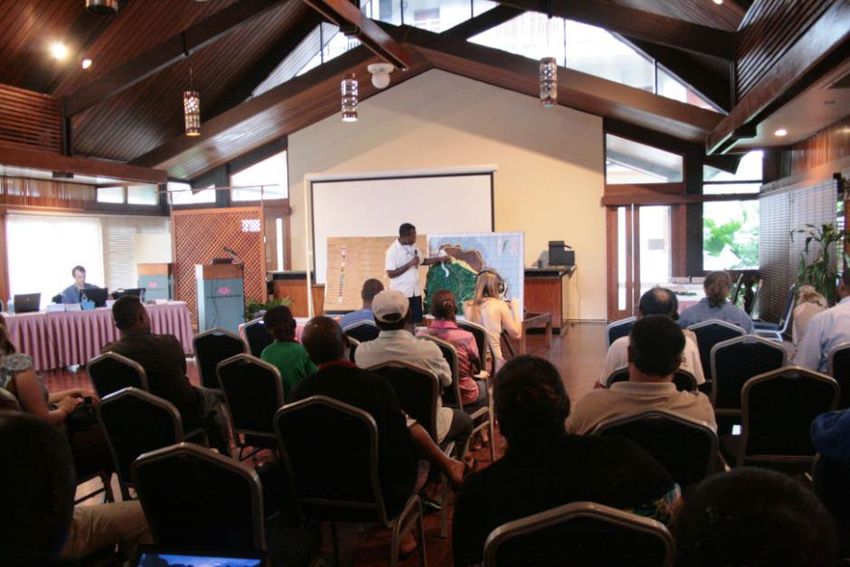
2
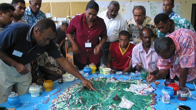
Table of Contents

1     EXECUTIVE SUMMARY ............................................................................................... 5
2     INTRODUCTION ........................................................................................................... 8
    2.1     Background............................................................................................................. 9
    2.2     Context ................................................................................................................... 9
    2.3     CTA Pacific Regional Business Plan ..................................................................... 10
    2.4     CTA investment .................................................................................................... 11
    2.5     Methodology ......................................................................................................... 13
3     P3DM IN THE PACIFIC ............................................................................................... 14
    3.1     Background........................................................................................................... 14
      3.1.1        Piloting Participatory 3D Modelling................................................................. 14
      3.1.2        Scaling-up P3DM ........................................................................................... 14
    3.2     Outputs ................................................................................................................. 15
      3.2.1        Capacity building in participatory spatial planning .......................................... 15
      3.2.2        Improving relationship with constituency and partners ................................... 18
      3.2.3        Capacity building in Web 2.0 and Social Media.............................................. 19
      3.2.4        Sharing, learning and networking opportunities.............................................. 19
      3.2.5        Publishing and disseminating knowledge products ........................................ 20
      3.2.6        Establishing centres of excellence in the Pacific ............................................ 21
    3.3     Outcomes: Replication and Effective Use ............................................................. 21
      3.3.1        Replication of the P3DM process ................................................................... 21
      3.3.2        Data back-up through extraction and digitization............................................ 23
      3.3.3        Training others in organizing and facilitating P3DM processes ...................... 24
      3.3.4        Disseminating information and showcasing P3DM ......................................... 24
    3.4     Assessing the impacts .......................................................................................... 26
      3.4.1        Mobilising funding and acquiring service contracts ........................................ 26
      3.4.2    Contribution to sustainable spatial planning and climate change
      adaptation .................................................................................................................... 27
      3.4.3        Safeguarding and transmission of cultural heritage ........................................ 30
      3.4.4        Influencing policy-making ............................................................................... 32
      3.4.5        Other environmental and socio-economic impacts ......................................... 32
      3.4.6        Using Participatory 3D Modelling as indicator of project success ................... 33
    3.5     Summary of findings ............................................................................................. 33
      3.5.1     R1: Best practices in the use of PGIS (and related web 2.0
      applications) and lessons learnt are well documented, widely disseminated and
      adopted in bottom-up planning and advocacy processes by selected national
      and regional bodies...................................................................................................... 34

                                                                                                                                       1
3.5.2 R2: Staff from selected regional and national organisations are
competent in using the PGIS practice and Web 2.0 applications in relation to
climate change adaptation in SIDS. ............................................................................. 35
3.5.3 R3: Regional centres of excellence in participatory spatial information
and communication are established in each of the two regions .................................... 36
4 CONCLUSIONS .......................................................................................................... 37
5 RECOMMENDATIONS ............................................................................................... 39
5.1.1 Funding and partnership opportunities ........................................................... 39
6 ANNEXES ................................................................................................................... 41
7 REFERENCES ............................................................................................................ 59
List of Tables
Table 1 Investment by CTA and partners in support to the adoption of PGIS in the
Pacific ................................................................................................................. 12
List of Figures
Figure 1 Ovalau Islands residents populating the 3D model (April 2005) .......................... 16
Figure 2 Villager describes the 3D model during the regional workshop in Honiara ............ 17
List of Boxes
Box 1 P3DM internationally recognized as a best practice .................................................. 20
Box 2 Reviving the history of the island: the crucial importance of Lovoni tribe ................... 31
Box 3 Discovering Samoan customs and traditional stories ................................................ 31
List of Annexes
Annex 1 Case study: Reconnecting aboriginal people with their Country: the case of
Mandingalbay Yidinji people ............................................................................... 41
Annex 2 Case study: Training of Trainers: the case of Partners with Melanesians............ 42
Annex 3 Case study: Preserving and transmitting cultural and landscape heritage in
Ovalau ................................................................................................................ 44
Annex 4 Case study: Scaling-up Participatory 3D Modelling in Samoa ............................. 46
Annex 5 Key events and products .................................................................................... 48
Annex 6 Partners and funding organisations..................................................................... 49
Annex 7 P3DM activities in the Pacific .............................................................................. 50
Annex 11 Excerpts from documentation - UNESCO Heritage Listing .................................. 56
Annex 12 Excerpts from Mid Term Review - ICCRIFS Project ............................................ 57
Annex 13 List of documented media coverage ................................................................... 61
Annex 14 List of Video Productions .................................................................................... 62
2List of Acronyms
3D Three-Dimensional
ACP African, Caribbean, Pacific
ARD Agriculture and Rural development
ASAP Adaptation for Smallholder Agriculture Programme
AusAID Australian Agency for International Development
CANARI Caribbean Natural Resources Institute
CBCAs Community-Based Conservation Areas
CEO Chief Executive Officer
CIMC Consultative Implementation and Monitoring Council
CROP Council of Regional Organisations in the Pacific
CTA Technical Centre for Agricultural and Rural Cooperation
FLMMA Fiji Locally Managed Marine Areas
GIS Geographic Information Systems
GPS Geographic Positioning Systems
ICCRIFS Integration of climate change risk and resilience into forestry management in Samoa
ICCRITS Integration of climate change risk and resilience in tourism in Samoa
ICKM Information Communication Knowledge Management
ICT Information Communication Technology
IFAD International Fund for Agricultural Development
ILC International Land Coalition
MNRE Ministry of Natural Resources and Environment (Samoa)
MPA Marine Protected Areas
NLTB Native Lands Trust Board
NZAID New Zealand Aid Programme
P3DM Participatory Three-Dimensional Modelling
PGIS Participatory Geographic Information Systems
PHC Periodically Harvested Closures
SPREP Secretariat of the Pacific Regional Environment Programme
PAFCO Pacific Fishing Company
PwM Partners with Melanesians
SamFRIS Samoa Forest Resource Information System
SPC Secretariat of the Pacific Community
SGP Small Grant Programme
SIDS Small Island Developing States
SP Strategic Plan
SPC Secretariat of the Pacific Community
SRIC-CC Strengthening the resilience of our islands and our communities to climate change
ToT Training of Trainers
TNC The Nature Conservancy
UNDP United Nations Development Programme
3USAID United States Agency for International Development
UWI University of West Indies
VCD Value Chain Development
5Cs Caribbean Community Climate Change Centre
WHS World Heritage Site
WTMA Wet Tropics Management Authority
WWF World Wide Fund for Nature
41 EXECUTIVE SUMMARY
After almost a decade since the introduction of Participatory Three-Dimensional Modelling
(P3DM) in the Pacific, this impact study is aimed at assessing the direct outputs, outcomes
and longer term impacts resulting from the interventions of the Technical Centre for
Agricultural and Rural Cooperation (CTA) in support of the introduction, adoption, and
replication of this process. By means of this study CTA takes stock of results achieved,
lessons learned, success stories, and is eager to identify areas for potential improvement
and upscaling. This study is based on face to face interviews, desk review and written
exchanges with selected informants.
Background and context
Support to the adoption and replication of P3DM in the Pacific is line with CTA vision and
corporate strategies. CTA 2007-2010 Strategic Plan (SP) drew attention on the potential of
PGIS for improving the quality of planning through a participatory approach and for
facilitating dialogue among disadvantaged communities and policy-makers. The 2011-15 SP
highlights climate change adaptation and mitigation as top priorities for the Centre. The
Regional Business Plan for the Pacific focuses on increasing resilience to climate change of
agricultural value chains. CTA support to participatory mapping builds on synergies with its
Web 2.0 and social media activities as well as value chain work.
Despite being very diverse, Pacific Island States present the perfect setting for implementing
PGIS/P3DM processes. The increasing threat of climate change and environmental
disasters has given prominence to reef to ridge approaches or integrated watershed
management and planning, which can best be applied with the support of geo-spatial
information methods. CTA identified the lack of a best practice in the position to enable local
knowledge holders to produce accurate and geo-referenced datasets with low technological
inputs as one of the main obstacles to increased community involvement in decision-making.
CTA efforts in promoting participatory mapping has been organised in two phases. The first
phase started with the piloting of P3DM in Ovalau Island in Fiji (in 2005) followed by the
adoption of P3DM in Papua New Guinea, Solomon Islands and East Timor. The second
phase was kick-started by an orientation and project planning workshop “Participatory
Mapping and Community Empowerment for Climate Change Adaptation Planning and
Advocacy” held in Honiara, Solomon Islands, in 2012 where lessons learnt from the first
phase were shared with a wide range of key stakeholders in the region. The workshop
launched a three year inter-regional project Promoting participatory ICTs for adding value to
traditional knowledge in climate change adaptation, advocacy and policy processes in the
Pacific and Caribbean (2012-2014) which saw widespread replication of P3DM in the Pacific
and the piloting of the process in the Caribbean. Through the PACC projects, UNDP
mobilized participants from Samoa, Cook Islands, Palau, Vanuatu and Solomon Islands. All
of these countries have either replicated the method or are planning to do so. This was a
result of both a successful targeting strategy and the organization of the workshop in two
parallel streams with a session dedicated to hands-on learning, including a field visit.
Outputs
At the level of individual staff taking part in the workshops in Ovalau and Honiara, trainees
internalised the added value of genuine participatory processes and incorporated it in the
work of their respective institutions. CTA supported the participation of staff from partner
organisations in attending face to face and or distance learning courses in the domain of
Web 2.0 and Social Media, as a useful complement to the skills acquired in participatory
geographic information methods. Many of those who were trained by CTA in Fiji (2005) and
Solomon Islands (2012) became actively involved both virtually and physically in an
international community of practice. Through financial support provided by CTA they had the
opportunity to take part as participants or resource persons in international conferences and
fora where they shared their P3DM experiences with peers and like-minded organisations.
5Furthermore, the Centre has been in the frontline in documenting and sharing PGIS/P3DM
related experiences. Partners and local media have been also active in documenting P3DM
processes. Throughout the years CTA continued to monitor and encourage the use of the
process in the region. By providing highly specialized training and mentoring services CTA
contributed to the establishment of solid P3DM centres of excellence: one in PNG (NGO
Partners with Melanesians) and one in Samoa (consisting of a team from the ICCRIFS
project and staff from the Ministry of Natural Resources and Environment).
Outcomes
Outcomes (i.e. the use of the acquired skills and knowledge in practicing P3DM and social
media) were very satisfactory with the notable exception of partners’ efforts in exporting
community-generated data in GIS. Data extraction and digitization was conducted only in
selected cases and overall did not receive due attention. As previously mentioned replication
has accelerated since 2012. Two of the partner organisations (PwM and TNC) have been
actively involved in scaling-up the process. The Wet Tropics Management Authority (WTMA)
introduced P3DM with an aboriginal group in Australia in 2014. Replication was strongly
driven by the training of trainers’ approach which is a building block of CTA approach.
Finally, all partner organisations have been putting significant effort in disseminating and
showcasing their experience with P3DM with the support of CTA and TNC. Showcasing
success proved important not only for promoting replication but also for securing additional
funding.
Impacts
For the purpose of this study impacts refer to medium and long term changes within partner
organisations. Partners were able to mobilise funds and acquire new service contracts on
the basis of their reputation and proven record of success in implementing P3DM. There is
evidence that CTA-led activities in the domain of P3DM have directly or indirectly contributed
to many positive changes. These include supporting sustainable spatial planning and
management, safeguarding cultural and landscape heritage, creating a platform for different
generations to come together and learn from each other, providing additional sources of
income and new livelihood opportunities. Finally, through P3DM local communities were able
to influence local development policies, especially in Samoa.
Conclusions
CTA support to the introduction, adoption and replication of PGIS/P3DM fulfilled all expected
results defined in the framework of the project Promoting participatory ICTs for adding value
to traditional knowledge in climate change adaptation, advocacy and policy processes in the
Pacific and the Caribbean and set as an assessment framework for this study. Best
practices and lessons learnt were adequately documented, disseminated and adopted. All
the interviewees fully understood the value added of participation in planning and advocacy
process and applied the code of ethics and the new facilitation skills in their work. Staff from
selected regional and national organisations is competent in using the PGIS practice and
Web 2.0 applications in relation to climate change adaptation. Web 2.0 and social media
was very useful to establish networks, reinforce partnerships, and start new collaborations.
The establishment of regional centres of excellence in the Pacific is likely to create new
avenues for expanding the use of P3DM in the region (for example, through South-South
cooperation initiatives) and new P3DM are already in the pipeline. Main lessons include the
need for long-term relationship of trust with partner organizations and long-term presence of
these organizations and their staff on the ground. When government is willing to genuinely
work with communities, ministries and government agencies are best positioned to ensure
solidity, continuity and mainstreaming of the process. Community ownership is also essential
and can be insured through inclusive processes based on free prior informed consent.
Although the cost of PGIS/P3DM activities is relatively low for the standards of development
agencies, the main obstacle to replication for Pacific Island Countries remains availability of
funding. Along with the GEF small grant programme, CTA should explore opportunities to
6work in partnership with IFAD Adaptation for Smallholder Agriculture Programme and
SPREP, which is a key partner in the region.
72 INTRODUCTION
The adoption of Participatory Geographic Information Systems (PGIS) coupled with acquired
skills in using web 2.0 applications and social media has proved to add value and authority
to local knowledge and enable grassroots communities to have a voice in influencing policy
development.
This impact study is aimed at assessing the direct outputs, outcomes and longer term
impacts resulting from the interventions done by the Technical Centre for Agricultural and
Rural Cooperation (CTA) in support of the introduction, adoption, and replication of
Participatory Three-Dimensional Modelling (P3DM) 1 processes in the Pacific Region. CTA
interventions occurred in two phases. The first phase was marked by the introduction of
P3DM through a pilot project in the island of Ovalau (Fiji) in 2005 2 followed by nurturing
networking, information exchange and remote coaching. This first P3DM exercise aimed at
building capacity among technology intermediaries in the region. In 2007 the Ovalau process
was granted the World Summit Award in the category e-culture.
The second phase was centred on a land mark event in 2012: a regional orientation and
project planning workshop in the Solomon Islands 3 aimed at sharing results and lessons
learnt from the first phase and boost the spread of the P3DM method in the region to
influence climate change adaptation, advocacy and policy processes.
In the Pacific, CTA work on P3DM will be assessed against the following three expected
results defined in the framework of the 2012-2015 project “Promoting participatory ICTs for
adding value to traditional knowledge in climate change adaptation, advocacy and policy
processes in the Pacific and Caribbean”. These results apply also to activities carried out
during the period 2005-2011 and were chosen as a common assessment framework.
• R1: Best practices in the use of PGIS (and related Web 2.0 applications4) and
lessons learnt are well documented, widely disseminated and adopted in bottom-up
planning and advocacy processes by selected national and regional bodies.
• R2: Staff from selected regional and national organisations are competent in using
the PGIS practice (and Web 2.0 applications) in relation to climate change adaptation
in Small Island Developing States (SIDS).
• R3: Regional centres of excellence in participatory spatial information and
communication are established in each of the two regions5.
For the purpose of this report direct outputs refer to the actual products generated (e.g.
knowledge products, events, trainings) and include changes in capability of the partner
organisations or individuals representing such organisations as a direct result of CTA’s
intervention. Outcomes refer to the use of the acquired knowledge and change in capability,
including sharing lessons learned, replicating P3DM, training other individuals or
organisations, liaising and establishing partnerships. Medium and long term impacts within
1 P3DM is a spatial visualisation method falling under the umbrella term of participatory geographic
information systems (PGIS).
2 The Ovalau mapping exercise was conducted as part of the CTA project “Collaborative Spatial
Information and Communication Management in the Pacific”.
3 The workshop “Participatory Mapping and Community Empowerment for Climate Change Policy
Making” was held in Honiara, Solomon Islands, in May 2012 as part of the three-year Project
“Promoting participatory ICTs for adding value to traditional knowledge in climate change adaptation,
advocacy and policy processes in the Pacific and Caribbean”.
4 Capacity building in the domain of Web 2.0 and social media is complementary to PGIS as it
empowers communities to better share and communicate the outputs of PGIS activities and has been
ensured through the implementation of a dedicated sequence of sub-projects.
5 This report will cover the Pacific region only. A separate impact assessment report is planned for the
Caribbean region.
8the partner organisations refer, among others, to the use of outputs that contribute to
effective spatial planning and influence policy making, proven capacity to mobilise funds for
P3DM, and/or acquire service contracts to implement P3DM. On-the-ground impact usually
materialises as a result of post-mapping activities, which build on the outputs and outcomes
resulting from CTA-supported components (P3DM, and in some cases P3DM complemented
by Web 2.0, and Social Media capacity building).
After almost a decade since the introduction of P3DM in the region, by means of this study
CTA takes stock of results achieved, lessons learned, success stories, and is eager to
identify areas for potential improvement and upscaling. The analysis provided by this study
will be used to integrate PGIS/P3DM components into CTA’s Regional Business Plan for the
Pacific and leverage funding for up-scaling the use of the practice in the region.
2.1 Background
From the 1990s a solid body of knowledge and extensive experience was gained in South
East Asia in practicing PGIS in the context of collaborative natural resource management
and customary rights on resource tenure. In this context P3DM was widely used in
conjunction with Global Positioning Systems
Participatory Three-Dimensional (GPS) and Geographic Information System (GIS)
Modelling (P3DM) Method applications.
P3DM consists of a community-based
mapping method which integrates local Despite being very diverse, Pacific Island States
spatial knowledge with data on land share enabling regulatory, legal and cultural
elevations and sea depth to produce frameworks for P3DM. These are traditional
stand-alone, scaled and geo-referenced societies with strong chief leadership and mostly
customary land ownership (97% of land in Papua
relief models. Its core objective is to add
value to traditional knowledge and New Guinea, 90% in Vanuatu, 88% in Fiji, 87%
facilitate grassroots influence in policy-
in the Solomon Islands, 81% in Samoa).
making. Once the model is completed, a Furthermore, many Pacific Island States present
geo-referenced grid is applied on the the ideal land area for building stand-alone
model to facilitate data extraction and/or
import, digitisation and plotting. The
scaled relief models in the position to store
possibility of exporting to and importingcommunity-generated information. The
data from GIS provides a bridge between increasing threat of climate change and
technical and community-generated environmental disasters has given prominence to
knowledge (Piccolella et al. 2013). reef to ridge approaches or integrated watershed
management and planning, which can best be
applied with the support of geo-spatial information methods. Community-based mapping is a
fundamental way for displaying traditional environmental knowledge and for communicating
on issues related to the territory.
In the Pacific, the use of community-based geo-spatial information tools to support informed
decision-making was in its infancy when P3DM was first introduced in Fiji in 2005. While
some efforts had been made by NGOs and government agencies to introduce participatory
planning methods, most village communities still relied on traditional gatherings where
conversation is used as the main channel of communication. CTA identified the lack of a
best practice in the position to enable local knowledge holders to produce accurate and geo-
referenced datasets with low technological inputs as one of the main obstacles to increased
community involvement in decision-making. 6
2.2 Context
The CTA 2007-2010 Strategic Plan (SP) drew attention on the potential of PGIS for
improving the quality of planning through a participatory approach and for facilitating
6Rupeni et al. (2005) Report on the Participatory 3D Modelling & Participatory GIS Exercise held on
4-13 April 2005 on Ovalau Island, Fiji. WWF-SSP, July 2005.
9dialogue among disadvantaged communities in Africa, Caribbean and Pacific (ACP)
countries and policy-makers. Since then CTA has been spearheading a series of initiatives
aimed at sharing lessons learned, identifying gaps and building on institutional and
methodological synergies in the field. PGIS is in line with the Centre’s mandate to
‘strengthen policy and institutional capacity development and information and
communication management capabilities of ACP agricultural and rural development
organisations’.
The 2011-15 SP emphasises the disproportionate impact of climate change on food security
in SIDS. Climate change adaptation and mitigation are considered as top priorities by the
Centre. In response to this challenge, CTA expanded the PGIS thematic areas from land-
use and natural resource management to environmental and climate change. In this context
CTA promotes the establishment of enabling policy environments for implementing effective
long-term adaptation actions. The SP also aims at enhancing ACP countries capacity in
Information Communication Knowledge Management (ICKM) for agricultural and rural
development (Strategic Goal 3), for example through the deployment of ICT tools and
knowledge management practices favouring multi-stakeholder engagement and knowledge
sharing.
This report is produced within the framework of the 2014-2016 project MP3.1 ‘Enhancing
Institutional and Grassroots ICT Capacity to Influence Agricultural and Rural development
Processes and Value Chain development’ and specifically its Sub-project MP3.1.2
‘Participatory Spatial Information Management and Communication for Empowering
Grassroots in Climate Change Adaptation, Advocacy and Policy Processes’. Building on the
successful introduction of P3DM in the Pacific, the current sub-project and its 2012-2014
antecedent Promoting participatory ICTs for adding value to traditional knowledge in climate
change adaptation, advocacy and policy processes in the Pacific and Caribbean were
geared towards up-scaling the adoption of the practice in ACP regions.
2.3 CTA Pacific Regional Business Plan
Based on regions' agricultural-sector priorities and its own comparative advantages, CTA
has formulated Regional Business Plans (RBPs) for each ACP region, identifying pathways
for the transformation of agriculture and CTA's possible contributions to this process. Each
RBP identifies a set of actions that addresses challenges and realises opportunities specific
to that region. The main goal of CTA’s Regional Business Plan for the Pacific (2015-2017) is
to increasing resilience to climate change of agricultural value chains as stated in its subtitle
Building high-potential and climate-change-resilient agricultural value chains, and improving
the agriculture-nutrition pathway. This is essential in a region severely hit by the impacts of
climate change and weather extremes. Landscape has been changing for years in these
countries but there is limited knowledge and information sharing among stakeholders on the
impacts of climate change in the different areas and a meaningful engagement of
smallholder agricultural producers in value chain deliberations and negotiations is often
missing. Participatory 3D models can help overcome these challenges. 3D models can be
used to identify new areas of economic development (including new market opportunities,
new crops, or highlight the need to revive the production of traditional crops or traditional
cropping methods), support discussion on diversification strategies and – by giving an
holistic approach to landscape management – help to exploit the interlinkages between
sectors such as agriculture, tourism, industry. By adding value to indigenous knowledge
PGIS/P3DM helps developing the capacity of Pacific Island Countries to diversify production,
enhance productivity and add value through quality niche products.
P3DM and Regional Business Plan objectives
a) In line with the RBP objectives Participatory Three Dimensional Modelling helps (i)
“achieve targeted outcomes that are consistent with CTA’s strategic directions”, that is
desirable changes in policy design and implementation as well as in the lives and
10livelihoods of small-scale operators; and (ii) “regionally-defined agricultural and rural
development goals”, as the process is bottom up and opened-ended and therefore
customized to the regional, national and local context.
b) By increasing knowledge of their landscape and resources, as well as enhancing
dialogue among the different stakeholders, people taking part in PGIS activities are better
positioned to identify new employment opportunities including new “market opportunities”.
c) CTA support to PGIS activities in the Pacific is cautiously planned in advance and
negotiated with local partners in light of wider initiatives implemented in the region. This
ensures “CTA resources to be utilised optimally through avoiding overlaps and creating
synergistic effects”.
d) Because of the significant results achieved on the ground and widespread replication,
PGIS/P3DM provides “a medium for interaction with partners, including possible funding
agencies”.
P3DM and Regional Business Plan guiding principles
CTA has a demonstrated comparative advantage in PGIS and Web 2.0 and social media. It
has been promoting these activities in Africa, Caribbean and the Pacific for ten years and
has a recognized record of success. It has been able to establish strong partnerships with
local and regional organizations working in these domains. These partnerships are
backstopped by the support and inputs of a wide online community of practice that CTA staff
has coordinated and continues nurturing.
PGIS/P3DM activities maximise synergies and allow to take advantage of economies of
scale between different CTA programmes of work. Despite developed as part of the Polices,
Markets and ICTs (PMI) Programme, these activities complement and build on those of the
Knowledge Management and Communication (KMC) Programme 7. Building on synergies
originating from Sub-project MP3.1.1 ‘Upscale and institutionalise the use of Web 2.0 and
Social Media for ARD and VCD’, project MP3.1 8 promotes the accessibility and effective use
of PGIS, Web 2.0 and Social Media among its direct beneficiaries to stimulate their active
participation and the one of their constituencies (indirect CTA beneficiaries) in planning out
climate change adaptation strategies and in feeding their findings and proposed solutions
into policy making processes. Both contribute to CTA’s strategic goal No. 3 Enhancing ACP
capacities in information, communication and knowledge management (ICKM) for
agricultural and rural development.
In line with the Regional Business Plan principles, PGIS/P3DM furthermore provides a
flexible practice for engaging both women and youth and highlights the value of Information
Communication Technology in the context of agricultural development.
In conclusion, PGIS/P3DM by i) providing a platform for bridging scientific and technical
information with traditional knowledge, ii) giving grassroots a voice to influence policy
making, iii) favouring inter-generational transmission of knowledge and, iv) preserving both
tangible and intangible cultural heritage “enables CTA to address the nexus between data,
policy, research, education/training, and practice / grassroots level programme
implementation”.
2.4 CTA investment
While financial investment in introducing and promoting the practice in the Pacific has been
limited since 2005 (see table below), great effort has been provided by CTA staff in: (i)
remotely coaching or training practitioners and their institutions; (ii) building the reputation of
7 This includes strengthening of methodologies, skills and tools for knowledge management through
the distribution of publications, trainings, virtual platforms, communication products etc.
8 ‘Enhancing Institutional and Grassroots ICT Capacity to Influence Agricultural and Rural
development Processes and Value Chain development’.
11institutions with proven track record in deploying P3DM; (iii) mobilizing resources via other
donor agencies; (iv) stimulating exchanges of experiences via e-discussion fora; (v)
documenting case studies; and (vi) facilitating professional linkages between individuals and
institutions. Therefore any assessment of CTA investment in P3DM cannot ignore cost-
effectiveness (i.e. costs compared to outcomes/impacts) and time-cost associated to these
activities as indicators.
Table 1 Investment by CTA and partners in support to the adoption of PGIS in the
Pacific
CTA Complementary
budget funding
CTA
Years (EUR) – Activity and Project framework (title)
Project ID
Pacific (EUR) source
PGIS
2004- 25210414 55,000 none N/A Support to the organisation and run of a P3DM exercise
2005 in Ovalau Island, Fiji
Project framework: Collaborative Spatial Information and
Communication Management in the Pacific
2005 27210536 9,000 none N/A Provision of support to 3 participants from the Pacific in
attending the Mapping for Change Conference in
Nairobi, Kenya
2007 25210414 9,000 none N/A Provision of support to 3 participants from the Pacific in
attending the 2007 WSA ceremony in Venice, Italy
Project framework: Collaborative Spatial Information and
Communication Management in the Pacific
2011 21212030 5,700 none N/A Film production
2012 11141012 16,804 38,000 GEF-SGP Facilitation of P3DM exercise in Trinidad and Tobago by
PNG practitioners (contract 2012-228)
Project framework: Promoting participatory ICTs for
adding value to Traditional Knowledge in Climate
Change adaptation, advocacy and policy processes in
the Pacific and Caribbean
2012 11141012 72,403 65,393 UNDP, Awareness Raising and Planning workshop on
TNC ‘Participatory Mapping and Community Empowerment
for Climate Change Adaptation, Planning and Advocacy’
Project framework: Promoting participatory ICTs for
adding value to Traditional Knowledge in Climate
Change adaptation, advocacy and policy processes in
the Pacific and Caribbean
2014 11143034 10,100 39,966 GEF- CTA participation in the 6th World Parks Congress and
IPAS related P3DM exercise among aboriginal people in
Queensland
Provision of support to 9 participants (4 from the Pacific)
in attending the Congress
Project framework: Participatory Spatial Information
Management and Communication for Empowering
Grassroots in Climate Change Adaptation, Advocacy
and Policy Processes’
12,000 UNDP
Total 178,007 155,359
122.5 Methodology
This study is based on face to face interviews, desk review and written exchanges with
selected informants. Forty in-depth semi-structured interviews – conducted in the period 12 -
28 November 2014 – were recorded and transcribed for analysis. The interviews were held
at the sixth IUCN World Parks Congress in Sydney and in the field (Fiji and Samoa) 9. Most
of the meetings in the field were arranged ahead of arriving in the country. The participation
of the consultant in the World Parks Congress allowed her to fine-tune the field-work
schedule and meet with key resource people 10 involved in the implementation and funding of
P3DM-related activities in the Pacific. Furthermore, the sessions organised by CTA and
partner organisations on the topic also provided valuable information. While on the field, the
consultant had the opportunity to visit the locations where the Participatory Three-
Dimensional Models are stored and meet with both partner organisations (NGOs,
Government and International Organisations) and villagers who took part in the mapping
exercises and follow-up actions. Written exchanges and Skype conferences were necessary
to collect supporting documentation and cross check data and figures. Detailed information
on the field meetings is available in Error! Reference source not found., Error! Reference
source not found. and Error! Reference source not found..
9 Since field interviews were conducted only in these two countries, results reported focus mainly on
these cases.
10 Based in Papua New Guinea, Australia, Fiji, Samoa and Switzerland.
133 P3DM IN THE PACIFIC
3.1 Background
3.1.1 Piloting Participatory 3D Modelling
Ovalau Island in the Lomaiviti Province of Fiji was identified as the site for pilot testing P3DM
practice in the Pacific because of the presence of several favourable factors: on-going
initiatives which could benefit from appropriate mapping methods, a positive response from
local community leaders, a rich local history and tradition, and the presence of some still
pristine terrestrial and coastal ecosystems. The Fiji Locally Managed Marine Areas (FLMMA)
Network 11 recognised the potential of the P3DM method for addressing overfishing and
unsustainable farming practices and at the same time was looking into new ways for
reaching out to local communities. Furthermore in order to protect its unique cultural
heritage, Levuka, the old capital city located on Ovalau Island had been proposed as
UNESCO World Heritage Site (WHS). At that time the various agencies involved in the
process were struggling to engage local communities. Raising community awareness on the
value of their cultural heritage and documenting traditional knowledge on the history and
customs of the island were essential pre-requisites for supporting the proclamation process.
On a more practical note, Ovalau Island was well documented in terms of topographic and
bathymetric data, elevation contours and bathymetric lines being essential inputs in a 3D
modelling exercise. The size of the island was considered ideal to develop a 3D model at
1:10,000 scale.
Mapping, including participatory mapping, was not new to conservation workers in Fiji.
According to the Chair of FLMMA, Mr Alifereti Tawake, this was “an expansion or
improvement of ongoing work”. FLMMA and its members such as the World Wide Fund for
Nature (WWF) – who prepared the Project proposal for the P3DM exercise – were using
participatory sketch mapping, satellite images and Geographic Positioning Systems (GPS).
In 2004 a PGIS process combining orto-photomaps and Qoliqoli (traditional fishing grounds)
maps was started to develop a qoliqoli Management Plan by the Ministry of Tourism, the
Beqa Island Tourism Council, the University of the South Pacific (USP) and the Native Land
Trust Board (NLTB). Participants - who worked in groups - produced seven sets of separate
annotated pictures. No comparison between the outputs occurred and the actual planning
was deferred until the set of pictures had been compiled in GIS by facilitators ex situ (that is
in their offices). Due to the lack of funding, facilitators did not bring the final maps back to the
community, validation of the GIS maps by the workshop participants did not take place and
the expected management plans were not produced. The Beqa Island exercise raised
ethical questions about the building blocks of participation: ownership, empowerment,
control, access and use 12.
3.1.2 Scaling-up P3DM
The successful introduction and adoption of P3DM firstly in Fiji and later in Papua New
Guinea, Solomon Islands and East Timor suggested its appropriateness in the context of
SIDS, especially in face of the increasing threat of environmental and climate change, and
related disasters. At the same time grey literature highlighted the value of P3DM for planning
climate change adaptation because of the technical characteristics of the method and of its
process bridging top-down interventions with bottom-up contribution of the affected
11 The Fiji Locally Managed Marine Area (FLMMA) network is a non-profit and charitable association
working to promote and encourage the preservation, protection and sustainable use of marine
resources in Fiji by the owners of marine resources. It consists of members representing the island’s
village communities, research institutes and international non-profit organisations.
12
For a comparative analysis read: Rambaldi, G. Tuivanuavou, S. Namata, P. Vanualailai, P. Rupeni,
S. and Rupeni, E. 2006. Resource use, development planning, and safeguarding intangible cultural
heritage: lessons from Fiji Islands in IIED Participatory Learning and Action (PLA 54).
14communities 13. In such a context CTA designed the three-year inter-regional 2012-2014
project Promoting participatory ICTs for adding value to traditional knowledge in climate
change adaptation, advocacy and policy processes in the Pacific and Caribbean.
The project was aimed at scaling up the use of P3DM/PGIS in the region and introduce it to
the Caribbean, starting with Trinidad and Tobago. CTA collaboration was requested by
partners in the two regions because of its expertise in the domain of PGIS practice, Web 2.0
and Indigenous Knowledge Management. This project was nested into larger climate change
adaptation initiatives funded by UNDP, TNC, AusAID, and GEF-SGP (~34.3 Million USD).
Other involved actors include various national governments in the Pacific, and the
Universityof West Indies (UWI), the Caribbean Natural Resources Institute (CANARI) and
the Caribbean Community Climate Change Center in the Caribbean.
3.2 Outputs
Outputs refer to the actual products generated (e.g. trainings, events, knowledge products,)
and include changes in capability of the partner organisations or individuals representing
such organisations as a direct result of CTA’s intervention.
3.2.1 Capacity building in participatory spatial planning
CTA was directly involved in the organisation of two events having capacity building
purposes. The first took place in Ovalau, Fiji in April 2005 and the second one in Honiara,
Solomon Islands in May 2012.
Ovalau workshop
In Fiji 30 students and close to 100 people from 27 villages – with the support of 18 trainees
and three resource persons from 15 different local, regional and international institutions 14 –
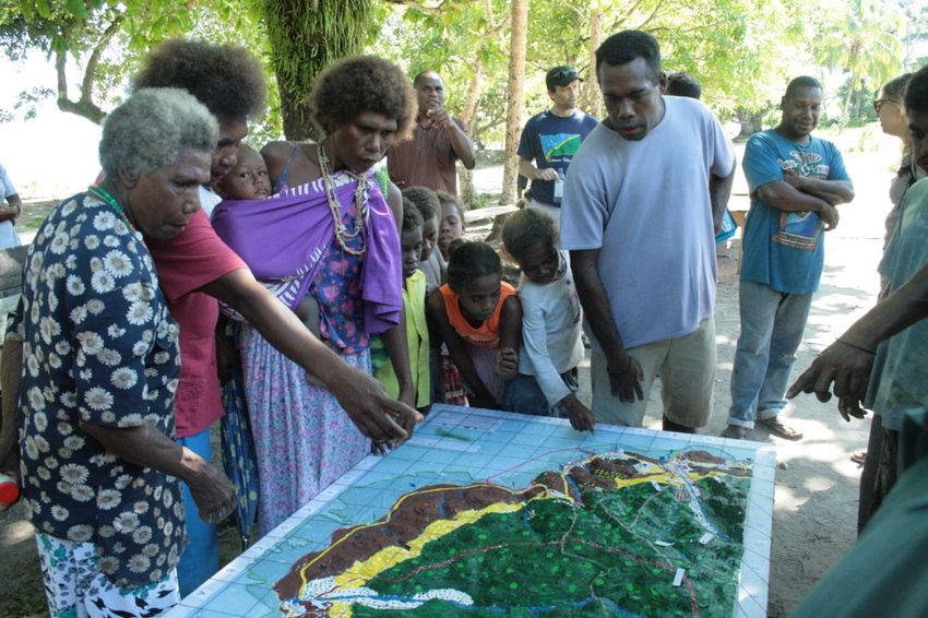
built a Three-Dimensional Model of the entire island. The model helped identifying 79 types
of legend items 15 including 35 different land uses and covers and 83 places of cultural
heritage significance.
Participating organisations significantly benefited from taking part in the modelling exercise
at different levels.
At the level of individual staff taking part in the workshop, trainees internalised the added
value of genuine participatory processes and incorporated it in the work of their respective
institutions. Vilimaina Civavonovono, Senior Technical Assistant at the Fiji Ministry of
Agriculture – who has been working in the GIS Unit of the Land Resources Planning and
Development Division of Fiji for 12 years – claimed: “I am conscious now when I do my
mapping I must understand the purpose of the map. Especially if this information can create
conflicts. […] What I learnt is the importance of the participatory process”. The workshop
raised awareness on how to work with communities while respecting ethical principles:
“handing over the stick” (i.e. not imposing choices and behaviours), being transparent,
allowing time, ensuring ownership of the final product. This resulted particularly important in
Fiji where, as in many developing countries, the growth imperative often contrasts with the
13 Piccolella, A. ‘Participatory mapping for adaptation to climate change: the case of Boe Boe,
Solomon Islands.’ Paper submitted in August 2011 to the London School of Economics and Political
Science, later published on the Knowledge Management for Development Journal (2013) 9(1): 24-36.
14 CTA, Native Lands Trust Board (NLTB), WWF, Partners With Melanesians Inc., The Nature
Conservancy, Wet Tropics Management Authority, FLMMA, Ministry of Fisheries and Forest,
University of the South Pacific, Ministry of Agriculture, National Trust of Fiji, Lomaiviti Provincial
Officer, Ministry of Tourism, SOPAC/EU Project "Reducing Vulnerability in the Pacific ACP States”,
SPC.
15 Points, lines and polygons in the form of pins, yarns and paint represented land use and cover,
households, schools, churches, economic activities, places of cultural interest, traditional fishing
grounds etc.
15need to safeguard both local culture and increasingly vulnerable marine and terrestrial
ecosystems.
Figure 1 Ovalau Islands residents populating the 3D model (April 2005)
Sukulu Rupeni, who used to work as the FLMMA Communication Coordinator, right after the
Ovalau workshop prepared a proposal with the Institute of Applied Science (IAS) for
engaging youth in climate change adaptation through a series of participatory learning and
action techniques including participatory theatre. She also used mapping for identifying
disaster prone areas and adaptation planning. She recalls having noted how participants
and the community at large felt empowered through the P3DM exercise and that that was
truly inspirational for her.
According to M’Lis Flynn, Project Officer at the Australian Wet Tropics Management
Authority (WTMA) being involved in that training, learning to be a facilitator, made her realize
she really enjoyed community facilitation. “I really enjoy that role and P3DM is such a good
technique that I wanted to make it happen somewhere else”. And this was what she did in
October 2014 when she coordinated the first P3DM done from beginning to the end by an
aboriginal group in Australia (see Annex 1 Case study: Reconnecting aboriginal people with
their Country: the case of Mandingalbay Yidinji people, page 41).
Partners with Melanesians Inc. (PwM) – a Papua New Guinea-based NGO – used to
generate maps for proposed conservation areas starting from waypoints collected through
GPS. Field work had to be often interrupted because of adverse weather conditions and
challenging logistics. Discovering an alternative method for producing scaled maps reflecting
grassroots’ knowledge, priorities and perspectives revolutionised the way PwM works (see
Annex 2 Case study: Training of Trainers: the case of Partners with Melanesians on
page 42).
All interviewed trainees stated that their experience went beyond learning the different steps
of a new mapping methodology.
Honiara workshop
The Orientation and Project Planning workshop Participatory Mapping and Community
Empowerment for Climate Change Adaptation Planning and Advocacy was aimed at
reinforcing the process started in Ovalau in 2005, share lessons learnt and reinvigorate
16replication. CTA, PwM, TNC and UNDP formed a unique partnership to capitalize on their
experience and networks in the Pacific and make sure that key stakeholders were exposed
to the method.
The landmark event brought together more than 80 people from 17 countries, including
Australia, Cook Islands, Federated States of Micronesia, Fiji, Italy, The Netherlands, New
Zealand, Palau, Papua New Guinea, Philippines, Samoa, Solomon Islands, St. Vincent and
the Grenadines, Trinidad and Tobago, UK, USA, and Vanuatu.
Figure 2 Villager describes the 3D model during the regional workshop in Honiara
The workshop was structured in two parallel streams. While participants were exchanging
experiences about participatory GIS practice and the role of innovative ICTs in facilitating
community empowerment and active participation in decision-making and how P3DM can be
used to document, geo-reference and visualise local knowledge, selected residents from
Naro village in Guadalcanal were building a mini-3D model of their village area. Participants
were exposed to a practical demonstration of the different steps in the process. They were
also exposed to participatory videos and web-based applications which could be used to
complement the map-making process and add authority to its outcome. At the end of the
workshop they were aware of the importance of obtaining Free Prior Informed Consent
(FPIC) and the potential risks involved in practicing participatory mapping and related
mitigation measures. The success of the event was precisely linked to the combination of
theoretical sessions, with hands-on learning and more interactive sessions were participants
were given the possibility to plan their own country-specific P3DM activities. According to
Gabor Vereczi, UNDP Technical Advisor for the Pacific Region and Pacific Adaptation to
Climate Change (PACC) Coordinator, “the fact that the model was built right there made it
very real. The most impressive part of the workshop was to take the model to the village.
The villagers recognised what is in their land. They started discussing among each other and
teaching to the kids. People identify themselves with it.” This was key for convincing UNDP
to further assist their national partners to uptake the method.
173.2.2 Improving relationship with constituency and partners
The value added of P3DM is the process of building trust, getting to know and learning from
each other both at the community level, among the community and the project people, and
among the different partners involved.
In Fiji because of its unique characteristics, the P3DM exercise in Ovalau provided an
excellent team-building environment. Traditional facilitation methods including open
discussion, focus groups or presentations are often based on passive listening and can
amplify power unbalances among the different actors. Government bodies and staff are
often mistrusted. Technical experts use language and modes of communication which may
be difficult for community members to understand. P3DM modifies the traditional logic and
gives voice to local traditional knowledge holders. Everybody can touch the model and
contribute with his knowledge avoiding direct confrontation. The model becomes a medium.
According to Ms Civavonovono from the Ministry of Agriculture, the institution could
appreciate the value of working with communities and getting their consent before
implementing initiatives. FLMMA saw in P3DM an innovative way to approach and work with
local communities in Ovalau. De facto, the P3DM paved the way for extensive community
work. A planning workshop directly linked to the P3DM took place in July 2005. Other
meetings followed. The involvement of students was a milestone for FLMMA and since then
youth has always been engaged in project activities. Within the network “that process added
value to our partnership in FLMMA. The technical people, like government officials and GIS
experts, suddenly had a role in terms of community management” (Etika Rupeni, IUCN,
former WWF staff). At the time of the P3DM workshop the FLMMA Network was relatively
young. Throughout the process working relationships strengthened and improved.
In Samoa, the establishment of a relationship of trust
The P3DM model provided a bridge was the turning point in the ICCRIFS project.
with the community in terms of
According to the Agroforestry Officer, Luaiufi Aiono,
seeing and relating to the end
product of the project. (Yvette
without such a relationship the project would have not
Kerslake, ICCRIFS Project been able to achieve the same results. Working
Coordinator) together on the models (a total of 16 were produced
in Samoa as of the writing of this report) helps better
conveying what the Project objectives are and its
expected impact on the community. Also P3DM helped the different divisions and ministries
to open a constructive dialogue and balance their views on the development of these areas.
For example, the Ministry of Agriculture has often interests conflicting with those of the
Ministry of Natural Resources and Environment. All relevant Ministries were involved in the
process and that helped conciliating interests and clarifying objectives. The broker role
played by the Ministry of Women, Community, Internal Affairs and Social Development was
also crucial. They established the first contact with the communities, which is a common
praxis in Samoa, and were involved throughout the process thus ensuring that gender
mainstreaming and community empowerment were taken in high consideration. It is
interesting to note that the model for the Apia catchment led by the Water Division was
initially planned to match and complement the model for Lake Lanoto’o. This would have
provided an overview of the landscape from reef to ridge and from ridge to reef on the other
side. However, because of a technical misunderstanding 16 the models are not proportionate
and cannot be joined.
16The Water Division used the double number of cardboards assuming that a larger scale (1:5,000 vs
1:10,000 used for the first models) would require such a change.
18“P3DM is a great tool for us in Samoa. It is really helping our communities, schools and all
stakeholders to understand the different scenarios, topography and the allocation of different
resources. I believe that is very helpful. Sometimes when we are carrying out consultations
people are a little bit confused on what we are talking about. A picture speaks more than 1000
words” (Suluimalo Amataga Penaia, Chief Executive Officer, MNRE).
In Epi Island in Vanuatu, for the first time Chiefs
“Attending the P3D modelling in
came together to discuss and agree on substantial 2005 and the recent Web 2.0
development projects. The island is much dissected training that was conducted in PNG
because of the presence of a volcano and there are in 2014 places myself and my
four different chiefs. Gabor Vereczi, PACC project organisation in a position that we
Coordinator said: “in the past it was very difficult to can easily communicate what we
achieve consensus over key issues. This project in are doing on P3DM to other
the framework of PACC deals with coastal stakeholders both at government
infrastructure for climate change… some critical level, local communities, with
infrastructure, quite investment heavy. If it wasn’t for access to internet and Facebook, to
very important policy makers as the
the model I don’t see how you could get a thorough
Minister himself and the Deputy
agreement among these chiefs. This helps taking Secretary”
very long term decisions.” (Kenn Mondiai, PwM, PNG)
In the Solomon Islands and PNG – where P3DM
was carried out by organizations with a long history of collaboration with the local
communities – the process reinforced long-term relationships of trust and set the ground for
further collaboration opportunities.
3.2.3 Capacity building in Web 2.0 and Social Media
In order to assist partner organisations to strengthen their capacities in sharing information,
communicating and advocating for policy reform or development, CTA supported the
participation of staff from partner organisations in attending face to face and or distance
learning courses in the domain of Web 2.0 and Social Media. This contributed to improving
their online visibility and reputation. PGIS/P3DM activities are best valued when they are
made visible and shared with the wider audience. Training in Web 2.0 for Development (or
Web2forDev) has been targeted in the Pacific to those countries and organisations which
could capitalise on existing PGIS capacity.
In 2011 and 2012 face to face Web 2.0 and Social Media trainings took place in Fiji, while in
2014 and 2015 face to face events took place in Cook Islands, Papua New Guinea,
Samoa and Vanuatu. Additional capacity building in the domain of Web 2.0 and Social
Media was offered over the period 2011-2015 via distance learning courses run by UNITAR
and paid for by CTA to individuals from Cook Islands, Fiji, Niue, Papua New Guinea,
Samoa, Solomon Islands, Tonga, Tuvalu and Vanuatu. Key stakeholders were trained
including staff from agencies involved in PGIS/P3DM processes specifically to enhance their
capacity to collaborate and to create, share and publish information and eventually mount
advocacy campaigns.
3.2.4 Sharing, learning and networking opportunities
Many of those who were trained by CTA in Fiji (2005) and Solomon Islands (2012) became
actively involved both virtually and physically in an international community of practice.
Through financial support provided by CTA they had the opportunity to take part as
participants or resource persons in international conferences and fora where they shared
their P3DM experiences with peers and like-minded organisations. Three participants took
part in the Mapping for Change Conference in Nairobi, Kenya in September 2005 and other
three took part in the World Summit Award ceremony in Venice, Italy in November 2007. For
19You can also read