ENVIRONMENTAL ASSESSMENT - Hartwell Dam and Lake Project Master Plan Savannah River, Georgia and South Carolina
←
→
Page content transcription
If your browser does not render page correctly, please read the page content below
ENVIRONMENTAL ASSESSMENT

      Hartwell Dam and Lake Project Master Plan

     Savannah River, Georgia and South Carolina

  (Hart, Franklin, and Stephens Counties in Georgia and
Anderson, Oconee, and Pickens Counties in South Carolina)

                     October 2021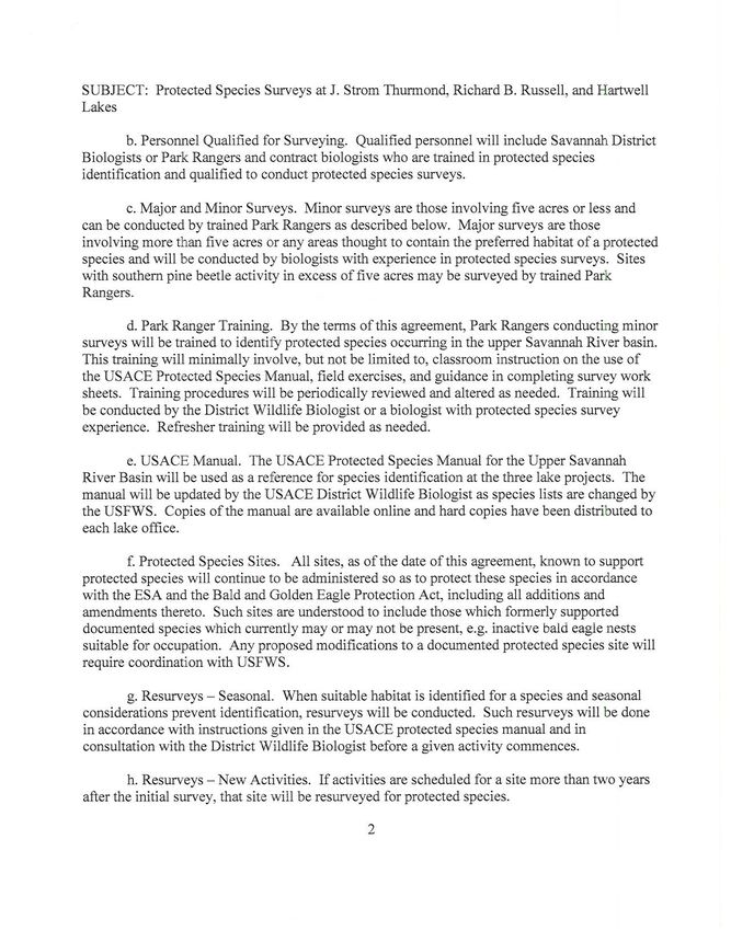
Hartwell Dam and Lake Project               Master Plan Environmental Assessment
Georgia and South Carolina                                       October 2021

                          This page purposely left blank.
Hartwell Dam and Lake Project                                        Master Plan Environmental Assessment
Georgia and South Carolina                                                                October 2021

                                                  Table of Contents

    INTRODUCTION. ...................................................................................................... 1
  1.1 Proposed Action. ................................................................................................... 1
  1.2 Purpose and Need for the Proposed Action. ......................................................... 3
  1.3 Authority ................................................................................................................ 5
  1.4 Prior Reports.......................................................................................................... 5
  1.5 NEPA Scoping ....................................................................................................... 5
    ALTERNATIVES TO THE PROPOSED ACTION...................................................... 5
    AFFECTED ENVIRONMENT .................................................................................... 6
  3.1 General .................................................................................................................. 6
     3.1.1 Description of the Watershed .......................................................................... 6
     3.1.2 Climate ............................................................................................................ 7
     3.1.3 Physiography and Geology ............................................................................. 8
     3.1.4 Soils ................................................................................................................ 9
  3.2 Relevant Resources ............................................................................................ 10
     3.2.1 Wetlands and Aquatic Vegetation ................................................................. 13
     3.2.2 Aquatic Resources and Fisheries.................................................................. 14
     3.2.3 Forest, Vegetation, and Bottomland Hardwoods ........................................... 14
     3.2.4 Wildlife........................................................................................................... 16
     3.2.5 Threatened, Endangered and Other Protected Species................................ 17
     3.2.6 Cultural Resources ........................................................................................ 18
     3.2.7 Recreational Resources ................................................................................ 19
     3.2.8 Aesthetics...................................................................................................... 20
     3.2.9 Socio-Economic ............................................................................................ 20
     3.2.10 Environmental Justice and Protection of Children ....................................... 26
     3.2.11 Air Quality .................................................................................................... 27
     3.2.12 Hydrology, Water Quality, and Water Supply .............................................. 27
     3.2.13 Hazardous, Toxic and Radioactive Waste (HTRW) .................................... 29
    ENVIRONMENTAL CONSEQUENCES .................................................................. 30
  4.1 Wetlands .............................................................................................................. 30
     4.1.1 Future Conditions with No Action .................................................................. 30
     4.1.2 Future Conditions with the Proposed Action ................................................. 30
  4.2 Aquatic Resources/Fisheries ............................................................................... 30

                                                                i
Hartwell Dam and Lake Project                                        Master Plan Environmental Assessment
Georgia and South Carolina                                                                October 2021

     4.2.1 Future Conditions with No Action .................................................................. 30
     4.2.2 Future Conditions with the Proposed Action ................................................. 31
  4.3 Floodplains .......................................................................................................... 31
     4.3.1 Future Conditions with No Action .................................................................. 31
     4.3.2 Future Conditions with the Proposed Action ................................................. 31
  4.4 Terrestrial Resources .......................................................................................... 31
     4.4.1 Future Conditions with No Action .................................................................. 31
     4.4.2 Future Conditions with the Proposed Action ................................................. 31
  4.5 Bottomland Hardwood Forest .............................................................................. 32
     4.5.1 Future Conditions with No Action .................................................................. 32
     4.5.2 Future Conditions with the Proposed Action ................................................. 32
  4.6 Wildlife ................................................................................................................. 32
     4.6.1 Future Conditions with No Action .................................................................. 32
     4.6.2 Future Conditions with the Proposed Action ................................................. 32
  4.7 Threatened and Endangered Species (TES) ....................................................... 32
     4.7.1 Future Conditions with No Action .................................................................. 32
     4.7.2 Future Conditions with the Proposed Action ................................................. 32
  4.8 Waterbodies......................................................................................................... 33
     4.8.1 Future Conditions with No Action .................................................................. 33
     4.8.2 Future Conditions with the Proposed Action ................................................. 33
  4.9 Cultural Resources .............................................................................................. 33
     4.9.1 Future Conditions with No Action .................................................................. 33
     4.9.2 Future Conditions with the Proposed Action ................................................. 33
  4.10 Recreational Resources .................................................................................... 33
     4.10.1 Future Conditions with No Action ................................................................ 33
     4.10.2 Future Conditions with the Proposed Action ............................................... 34
  4.11 Aesthetics .......................................................................................................... 34
     4.11.1 Future Conditions with No Action ................................................................ 34
     4.11.2 Future Conditions with the Proposed Action ............................................... 34
  4.12 Socio-Economic Resources ............................................................................... 34
     4.12.1 Future Conditions with No Action ................................................................ 34
     4.12.2 Future Conditions with the Proposed Action ............................................... 34
  4.13 Environmental Justice and Protection of Children ............................................. 35
     4.13.1 Future Conditions with No Action ................................................................ 35

                                                                ii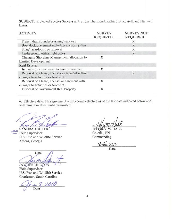
Hartwell Dam and Lake Project                                        Master Plan Environmental Assessment
Georgia and South Carolina                                                                October 2021

      4.13.2 Future Conditions with the Proposed Action ............................................... 35
   4.14 Air Quality .......................................................................................................... 35
      4.14.1 Future Conditions with No Action ................................................................ 35
      4.14.2 Future Conditions with the Proposed Action ............................................... 35
   4.15 Water Quality ..................................................................................................... 35
      4.15.1 Future Conditions with No Action ................................................................ 35
      4.15.2 Future Conditions with the Proposed Action ............................................... 36
   4.16 Hazardous, Toxic and Radioactive Waste (HTRW) ........................................... 36
      4.16.1 Future Conditions with No Action ................................................................ 36
      4.16.2 Future Conditions with the Proposed Action ............................................... 36
     CUMULATIVE IMPACTS ........................................................................................ 36
     COORDINATION .................................................................................................... 37
   6.1 Agencies and NGOs ............................................................................................ 37
   6.2 Public Involvement............................................................................................... 37
     COMPLIANCE WITH ENVIRONMENTAL LAWS AND REGULATIONS ................ 38
     CONCLUSION ........................................................................................................ 40
     PREPARERS .......................................................................................................... 41
       REFERENCES ...................................................................................................... 41

                                             Figures
Figure 1: USGS Hydrologic Units Hartwell Lake ............................................................. 6
Figure 2: Sampling Locations ....................................................................................... 29

                                                Tables
Table 1: Potential Recreational Facilities Development .................................................. 2
Table 2: Land and Water Classifications ........................................................................ 4
Table 3: Weather Summaries and Severe Events (1949 – 2016) ................................... 7
Table 4: Relevant Resources ........................................................................................ 11
Table 5: Wetland Summary .......................................................................................... 13
Table 6: Vegetative Resources .................................................................................... 15
Table 7: Protected Species Potentially Present at Hartwell Lake ................................. 18
Table 8: 2019 Population Estimates ............................................................................. 20
Table 9: Percent of Population Estimate by Gender .................................................... 21
Table 10: Age Distribution ............................................................................................ 21
Table 11: 2019 Population Estimate by Race/Hispanic Origin ..................................... 22
Table 12: Population Over 25 Level of Education Attainment ...................................... 23

                                                               iii
Hartwell Dam and Lake Project                                            Master Plan Environmental Assessment
Georgia and South Carolina                                                                    October 2021

Table 13: Employment by Sector (Percentage of Employed Civilian Population) ........ 24
Table 14: Labor Force Employment Rates ................................................................... 24
Table 15: 2019 Households and Household Size ........................................................ 25
Table 16: Median Household and Per Capita Income, 2019 ........................................ 25
Table 17: Population in Poverty, 2019.......................................................................... 26
Table 18: Relationship of the Proposed Action to Applicable Federal Laws and Policies
...................................................................................................................................... 38
Table 19: Summary of Potential Effects of the Proposed Action ................................... 40

                                                          Appendices

Appendix A: Land Classification Map
Appendix B: Terrestrial and Aquatic Plants, Animals, and Fish of Hartwell Lake
Appendix C: Memorandum of Agreement between the U.S. Army Corps of Engineers,
            Savannah District and the U.S. Fish and Wildlife Service
Appendix D: Comments on Environmental Assessment

                                                                   iv
Hartwell Dam and Lake Project                  Master Plan Environmental Assessment
Georgia and South Carolina                                          October 2021

                    ENVIRONMENTAL ASSESSMENT

                Hartwell Dam and Lake Project Master Plan

               Savannah River, Georgia and South Carolina

    INTRODUCTION.

The U.S. Army Corps of Engineers (USACE), Savanah District, has prepared this
Environmental Assessment (EA) to evaluate the potential impacts of the Hartwell Dam
and Lake Project (Hartwell Project) Master Plan (MP) hereinafter incorporated by
reference. This EA has been prepared in accordance with the National Environmental
Policy Act of 1969 (NEPA) and the Council on Environmental Quality’s (CEQ)
Regulations (40 CFR 1500-1508), as reflected in the USACE Engineering Regulation
(ER) 200-2-2. This EA provides information regarding the potential adverse and
beneficial environmental effects to allow the USACE District Commander to make an
informed decision on the appropriateness of signing a Finding of No Significant Impact
(FONSI) or preparing an Environmental Impact Statement (EIS).

1.1 Proposed Action.

The proposed action consists of updating the Hartwell MP which is required for USACE
water resource projects and other fee-owned lands where the USACE has
administrative responsibility for the management of natural and manmade resources.
The current MP was completed in 1981. The MP provides a programmatic approach to
the management of all the lands included within the Hartwell Project boundary and
serves as the basic document guiding USACE responsibilities pursuant to Federal laws
to conserve, restore, maintain, manage, and develop the projects lands, waters, and
associated resources. The MP is a planning document anticipating what could and
should happen and is flexible based upon changing conditions. Detailed management
and administrative functions are handled in the Operational Management Plan (OMP)
which translates the concepts of the MP into operations terms.

All potential recreational improvements discussed in the MP (Table 1), as well as
natural resource management actions, will be reviewed for compliance with applicable
laws and regulations, notably the Endangered Species Act, the Fish and Wildlife
Coordination Act, the National Historic Preservation Act, and the Clean Water Act. In
accordance with ER 200-2-2, Procedures for Implementing NEPA, the proposed activity
will be addressed by the appropriate categorical exclusion at the time of
implementation. Recreational improvements will occur in areas designated by land
classification as high-density recreation. For leased lands, the lessee must submit
detailed plans prior to approval of such facilities, infrastructure, or rights-of-way.
Engineer approved plans may be required and a feasibility and market analysis along
with public comment may be required for larger, revenue producing facilities. All state
and local ordinances apply.

                                           1
Hartwell Dam and Lake Project Master Plan Environmental Assessment
Georgia and South Carolina October 2021
Table 1: Potential Recreational Facilities Development
PUBLIC PARKS
Facilities approved on the lease Replacement, relocation, and/or
development plan modernization of existing facilities not
to exceed 10% of the original facility’s
footprint
Campsites not to exceed 25% of the existing Picnic Sites not to exceed 50% of the
number of campsites existing number of picnic sites
Yurts not to exceed 25% of the existing Portable or fixed mini cabins not to
number of campsites/yurts sites combined exceed 25% of the existing number of
campsites/yurts sites combined.
Sanitary facilities necessary to meet existing Conversion of picnic areas to
or expected demand including restrooms, campgrounds or campgrounds to
shower houses, septic systems, and RV picnic areas
dump station
Picnic shelter not to exceed 200-person Amphitheater not to exceed 250-
capacity person capacity
Designated parking lot(s) not to exceed 100 Disc golf course not to exceed 25
spaces acres in size
Archery or skeet range not to exceed 25 Additional lanes to existing boat
acres in size ramps. Realignment of roads to
improve safety and traffic flow at boat
ramps
Playground(s) Park office or gate house
Restaurant Hiking, biking, interpretive, fitness,
endurance, or equestrian trails or zip
lines/high ropes courses
Courtesy dock, fishing pier Park attendant/camp host sites
Fish cleaning station Swim beach
Shoreline erosion control Game court, ball field
Camp store not to exceed 1,000 square feet Designated pet friendly areas
Interpretive center Splash pad/mini water park not to
exceed one acre
2Hartwell Dam and Lake Project Master Plan Environmental Assessment
Georgia and South Carolina October 2021
PUBLIC MARINAS
Facilities approved on the lease development Replacement, relocation, and/or
plan modernization of existing facilities not
to exceed 10% of the original facility’s
footprint
Additional wet slip, dry stack, or open boat Marina office, ships store or gate
storage not to exceed 25% of the approved house
total of boat storage opportunities
Sanitary facilities necessary to meet existing Picnic shelters not to exceed 200-
or expected demand including restrooms, person capacity
shower houses, septic systems, and marine
pump out station
Amphitheater not to exceed 250-person Marine service and sales facility not to
capacity exceed 1 acre
Playground(s) Fish cleaning station
Courtesy dock, fishing pier Restaurant
1.2 Purpose and Need for the Proposed Action.
The purpose of the proposed action is to update the Hartwell Project MP in accordance
with the most recent guidance, EP 1130-2-550, dated 30 January 2013, and update
resource objectives and associated design and management concepts, which:
1. Provide the best possible combination of responses to regional needs, resource
capabilities and suitability, and expressed public interests and desires
consistent with authorized project purposes;
2. Contribute towards providing a high degree of recreation diversity within the
region;
3. Emphasize the qualities, characteristics, and potentials of the project;
4. Exhibit consistency and compatibility with national objectives and other state
and regional goals and programs.
The MP guidance includes revised categories of Land Classifications used to manage
project lands, as well as shifting from a construction-based document to a policy-based
document. All lands were acquired for authorized project purposes and allocated for
those uses. The classification process further distributes project lands by management
categories which, based upon resources available and public needs, will provide for full
utilization while protecting project resources. The guidance also includes requirements
for an interdisciplinary team approach for the development, re-evaluation, and
supplementation or updating of the MP. Coordination with other agencies and the
public is an integral part of the process. Land and water classifications based on the
revised categories are in Table 2.
3Hartwell Dam and Lake Project Master Plan Environmental Assessment
Georgia and South Carolina October 2021
Table 2: Land and Water Classifications
Land Classification Acres
Project Operations 68.0
High Density Recreation (includes Future/Inactive) 5,875.5
Environmental Sensitive and Natural Areas 7,626.7
MULTIPLE RESOURCE MANAGED LANDS
Low Density Recreation 8,345.8
Wildlife Management 1,650.0
Vegetative Management 0
TOTAL LANDS 23,566.0
Water Classification
Surface Water: Restricted 37.6
Surface Water: Designated No-Wake 350.5
Surface Water: Fish and Wildlife Sanctuary 0
Surface Water: Open Recreation 55,562.5
TOTAL WATER 55,950.6
The MP serves two primary purposes that are equal in importance. First, it is the
primary management document for the project and provides direction for many of the
other plans that also guide the management of the Hartwell Project. Second, it is a
land use management tool. This MP sets the stage for the update of many of the
resource management plans, such as the Shoreline Management Plan (SMP).
As a land use tool, this MP provides the USACE, resource agencies, and the public
with the classification and preferred future uses of project lands. The land classification
of project lands allows the USACE and the public to visually evaluate the distribution of
uses of project lands (Appendix A). For example, the identification of project lands that
are suitable for the development of a new recreation facility by the USACE, a lease
holder, or a future development is beneficial. Maintaining an up-to-date MP allows the
USACE to respond effectively to internal and external development plans.
The Hartwell Project MP includes a Geographic Information Systems (GIS) database.
The database can be continually updated throughout the life of the plan to allow the
USACE to take proactive management actions and adapt existing strategies.
The policy-based MP, along with this EA, provides the USACE with a document that
sets goals and objectives but does not establish concrete development plans. This
allows the USACE flexibility in the management and development of the Hartwell
Project within a clear policy framework.
4Hartwell Dam and Lake Project Master Plan Environmental Assessment
Georgia and South Carolina October 2021
1.3 Authority
Pursuant to USACE ER 1130-2-550, a MP is required for Civil Works projects and other
fee-owned lands for which the USACE has administrative responsibility for management
of natural, recreational, and cultural resources throughout the life of the water resource
project. A general plan on the comprehensive development of the Savannah River
Basin for flood control and other purposes was approved by the Flood Control Act of
17 May 1950 as the second unit in the comprehensive development of the
Savannah River Basin.
Development and utilization of reservoir lands for public access and recreational use
was authorized by Section 4 of the Flood Control Act of 1944, and as amended in 1946,
1954, and 1962. The Hartwell Powerplant became operational in April 1962. The lake
impounded by Hartwell Dam covers 55,950 acres and extends 49 miles up the Tugaloo
River and 45 miles up the Seneca River at the normal pool elevation of 660 feet above
mean sea level (amsl) for a total shoreline of 962 miles. There are 79,516 acres of land
and water in the Hartwell Project. Interstate 85 bisects Hartwell Lake and makes the
area easily accessible to visitors.
1.4 Prior Reports
Design Memo Title
22B(C-5) Hartwell Reservoir Sept. 1970
1981 Master Plan Update
1.5 NEPA Scoping
In June 2018, notification letters were sent to all stakeholders requesting input into
proposed changes or improvements they would like evaluated and incorporated into the
MP update. The Hartwell Project did not receive any responses.
In April 2021, the proposed action was coordinated with appropriate Federal, state, local
agencies, businesses, organizations, and the public through a 30-day review and
comment period on the draft EA and FONSI. In addition, the documents were posted on
the Savannah District website.
ALTERNATIVES TO THE PROPOSED ACTION
The one alternative to the proposed action considered was no-action, or future without
project condition. In the future without project condition (i.e. no-action), Hartwell Project
would continue to operate under the 1981 MP. As a result, individual Environmental
Assessments could be required for development of facilities or conducting activities not
addressed in the 1981 MP. In accordance with ER 1130-2-550, an updated MP (5-year
review) is required for civil works projects and other fee-owned lands for which USACE
has administrative responsibility for management of natural, recreational, and cultural
5Hartwell Dam and Lake Project Master Plan Environmental Assessment
Georgia and South Carolina October 2021
resources throughout the life of the water resource project, therefore, no-action is not a
viable alternative.
AFFECTED ENVIRONMENT
3.1 General
The Hartwell Project extends 49 miles up the Tugaloo R i v e r and 45 miles up the
Seneca River at the normal pool elevation of 660 feet amsl. There are 79,516
acres of land and water in the entire project. Interstate 85 bisects Hartwell Lake and
makes the area easily accessible to visitors. Hartwell Project covers parts of Hart,
Franklin, and Stephens Counties in Georgia, and Anderson, Oconee, and Pickens
Counties in South Carolina. The Savannah River forms part of the boundary line
between the States of Georgia and South Carolina, and the total lake acreage is 55,950
acres. The dam consists of a 204-foot high, 1,900-foot long concrete gravity structure
flanked by two earth embankments for a total length of 17,852 feet. Detailed
information about the Hartwell Project can be found on the District website at:
https://go.usa.gov/xENpE.
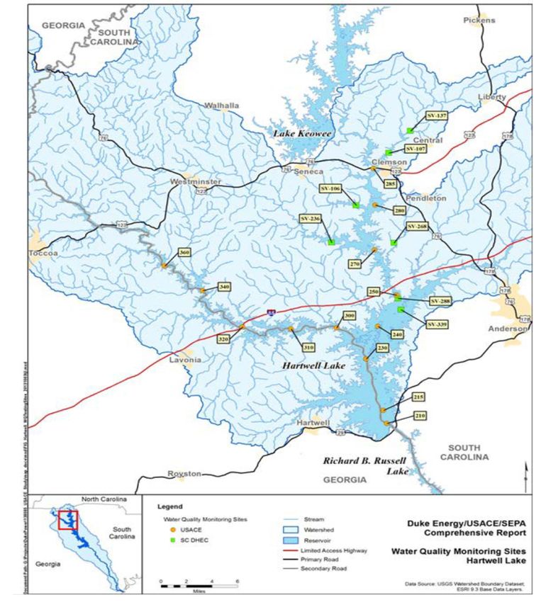
3.1.1 Description of the Watershed
The Savannah River Basin consists of 34 watersheds. Hartwell Project is in three
hydrologic units (HUC) (Figure 3). They are HUC 03060101 (Seneca), 03060102,
(Tugaloo), and 03060103 (Upper Savannah) https://water.usgs.gov/wsc/.
Figure 1: USGS Hydrologic Units Hartwell Lake
6Hartwell Dam and Lake Project Master Plan Environmental Assessment
Georgia and South Carolina October 2021
3.1.2 Climate
Hot, humid summers and mild, pleasant winters characterize the area on the shores of
Hartwell Lake. The following climate data for 1981-2010 was taken from Anderson
County, South Carolina which has a warm humid temperate climate with hot summers
and no dry season. The average high annually is 71.8° F and the average low is 50.4°
F.
Over the entire year, the most common forms of precipitation are thunderstorms, light
rain, and moderate rain. Thunderstorms are more prevalent from May to August. The
most rainfall occurs between mid-February and mid-March. The annual average rainfall
is 49.59 inches.
Snowfall is uncommon in the region with 32 frozen precipitation events occurring from
1993-2016. The South Carolina State Climatology Office
(www.dnr.sc.gov/climate/sco/ClimateData/countyData/county_anderson.php) reported
the following climate summaries and severe weather events for Anderson County, SC in
Table 3.
Table 3: Weather Summaries and Severe Events (1949 – 2016)
Summary
Temperature Summary (1952-2016)
Highest Maximum 108° F, July 29, 1952
Average High 71.8° F
Lowest Minimum -6° F, January 21, 1985
Average Low 50.4° F
Precipitation Summary (1949-2016)
Highest Daily Rainfall 12.81 Inches, August 27, 1995
Annual Average 49.59 Inches
Rainfall
Wettest Year 77.41 Inches, 1964
Driest Year 29.08 Inches, 2016
Highest Daily 9.0 Inches, December 17, 1930
Snowfall
Severe Weather Events
Tornado 29 Tornadoes (1950-2016)
330 Wind events (winds exceeding 50 knots or 58 miles per
Thunderstorm Winds hour, 1955-2016)
Hail (>1.0 inch) 106 events (1955-2016)
Lightning 18 Lightning events (1993-2016)
7Hartwell Dam and Lake Project Master Plan Environmental Assessment
Georgia and South Carolina October 2021
3.1.3 Physiography and Geology
The following information is incorporated by reference from the Savannah River Basin
Watershed Protection Plan 2001, Georgia Department of Natural Resources,
Environmental Protection Division (GA DNR-EPD).
Physiography
The Savannah River basin contains parts of the Blue Ridge, Piedmont, and Coastal
Plain physiographic provinces, which extend throughout the southeastern United States.
Like much of the Southeast, the basin's physiography reflects a geologic history of
mountain building in the Appalachian Mountains and long periods of repeated land
submergence in the Coastal Plain Province. The Fall Line is the boundary between the
Piedmont and Coastal Plain provinces. This boundary approximately follows the contact
between older crystalline metamorphic rocks of the Piedmont Province and the younger
unconsolidated Cretaceous and Tertiary sediments of the Coastal Plain Province. As
implied by the name, streams flowing across the Fall Line can undergo abrupt changes
in gradient, which are marked by the presence of rapids and shoals. Geomorphic
characteristics of streams differ between the Piedmont and Coastal Plain provinces. In
the Coastal Plain, streams typically lack the riffles and shoals common to streams in the
Piedmont and exhibit greater floodplain development and increased sinuosity.
Geology
The Savannah River basin is located within three physiographic provinces: Blue Ridge,
Piedmont, and Coastal Plain. The Blue Ridge and Piedmont provinces, which
constitute all of the Hartwell project and approximately 60 percent of the Savannah
River basin, are underlain by crystalline metamorphic and igneous rocks. The
metamorphic rocks originally were sedimentary, volcanic, and igneous plutonic rocks
that have been altered by several stages of regional metamorphism as well as several
episodes of granite intrusion.
The majority of the exposed rocks of the Savannah River basin consist of several types
of gneiss, largely made up of biotite gneiss, granite gneiss, and amphibolite. Granites
are locally important in the basin as are metasedimentary rocks such as
metagraywackes, quartzites, and schists. Less than 0.1 percent of the Savannah River
basin is occupied by ultramafic rock units. Coastal Plain sediments constitute
approximately 40 percent of the Savannah River basin. Approximately 80 percent of
the sediments are sands and clays. The rest include calcareous sediments and
Quaternary alluvium.
The Coastal Plain sediments overlap the southern edge of the Piedmont Province at the
Fall Line and those sediments nearest to the Fall Line are Cretaceous to Eocene in age.
They are predominantly terrestrial to shallow marine in origin and consist of sand,
kaolinitic sand, kaolin, and pebbly sand. These sediments host the major kaolin
deposits in Georgia with many of these deposits found within the Savannah River basin.
Much of the southeastern Piedmont is covered by deeply weathered bedrock called
saprolite. Average saprolite thickness in the Piedmont rarely exceeds 20 meters, but
8Hartwell Dam and Lake Project Master Plan Environmental Assessment
Georgia and South Carolina October 2021
the thickness can vary widely within a short distance. A considerable amount of ground
water flows through the saprolite and recharges streams in the Piedmont. Saprolite is
easily eroded when covering vegetation and soil are removed. Extensive erosion of soil
and saprolite caused by agricultural practices during the 1800s and early 1900s
contributed a vast quantity of sediment into stream valleys, choking the streams and
raising the streams base level.
As conservation practices stabilized erosion, streams began to reestablish grade and
cut into the thick accumulations of sediments, remobilizing them into the major rivers
and eventually into reservoirs.
3.1.4 Soils
The Savannah River watershed in Georgia crosses 5 Major Land Resource Areas
(MLRA) where soils vary widely, ranging from nearly level to very steep, from shallow to
very deep, from excessively drained to very poorly drained, and from sandy to clayey.
There are some general trends with soils across the watershed.
Going from north to south, degree of slope decreases, water tables are generally
higher, and soil textures go from loamy in the Blue Ridge, to clayey in the Southern
Piedmont, to sandy or sandy over loamy in the Sand Hills, Coastal Plain, and Atlantic
Coast Flatwoods. About 6 percent of the watershed is in the Blue Ridge MLRA. Most
of the soils in this area formed from weathered granite, gneiss, and schist. These are
the steepest soils in the watershed, with slopes in most areas ranging from 25 to 60
percent.
Soils on the steeper slopes and higher elevations are commonly loamy throughout, are
brown to yellowish red, and are shallow or moderately deep to bedrock. Deep to very
deep, red clayey soils are common in less sloping areas at lower elevations. About 60
percent of the watershed is in the Southern Piedmont MLRA. Most of the soils in this
region are very deep, well drained, red clayey soils that formed from felsic, high grade
metamorphic or igneous rocks.
There is a significant area in the central part of this region that contains soils formed
from intermediate and mafic crystalline rocks. These soils have slower permeability
and are less acid than typical Piedmont soils. Also significant is an area in the lower
portion of the Piedmont that has soils formed from Carolina slate. These soils are still
clayey but have a higher silt content than typical Piedmont soils. The remainder of the
Savannah River watershed does not include the Hartwell area, but approximately 8
percent of the watershed is in the Carolina and Georgia Sand Hills MLRA; 17 percent of
the watershed is in the Southern Coastal Plain MLRA; and 9 percent of the watershed is
in the Atlantic Coast Flatwoods MLRA.
The predominate soil associations within the Hartwell Project are Cecil, Madison, and
Lloyd. Cecil soil associations generally consist of deep, well- drained soils that
developed in material weathered from granite, gneiss, and schist. These soils are found
9Hartwell Dam and Lake Project Master Plan Environmental Assessment
Georgia and South Carolina October 2021
in the uplands on the tops of broad plateaus, ridge tops, and hillsides. Slopes range
from 2 to 15 percent. Cecil soils are low in natural fertility, contain little organic matter,
and are strongly acid throughout the profile.
The Madison series consists of moderately deep to deep, well-drained soils that are
generally high micaceous throughout the profile. These soils formed on uplands in
material weathered from quartz and mica schist. Most of the acreage is on broad
stream divides and on smooth side slopes ranging from 2 to 15 percent.
Soils in the Lloyd association are situated on the Piedmont uplands with slopes ranging
from 2 to 10 percent except for some steep slopes adjacent to drainage ways. They
have a service layer of friable, sandy loam and a moderately permeable, dark red,
clayey subsoil, relatively high in moisture-holding capacity. The smoothest ridge tops,
which make up a large part of this association, are usually well managed and
agriculturally productive.
Every soil type existing on project lands was placed into recreation capability
categories, depending upon computed potential. For graphic conveyance of general
soil potentials around the lake, recreation capability categories were divided into the
best recreation potential, restricted recreation potential, and least recreation potential,
as follows:
The "best" soils category is generally composed of soils which have
characteristics suitable to development. These soils are best suited for
high density recreational activities requiring the least amount of rotational
use for area recovery.
"Restricted recreation potential" soils are those where a potential for
recreation exists, but guarded development is required due primarily to
slope and erodibility. These soils will support high density recreational
use but will require substantial maintenance and more frequent rotational
use to protect the natural resources. The soils are better suited for low
density recreational use.
“Least recreation potential” soils are those that include high water tables,
susceptibility to frequent flooding, and excessive slopes with rapid runoff.
These soils will support limited low-density recreational use but are best
suited for natural areas with minimal disturbance.
3.2 Relevant Resources
This section contains a description of the existing conditions of relevant resources that
could be impacted by the project (Table 4). The significant resources described in this
section are those recognized by laws, executive orders, regulations, and other
standards of National, state, or regional agencies and organizations; technical or
scientific agencies, groups, or individuals; and the general public. The following
resources have been considered and were not found to be present within the project
area: coastal wetlands, cypress tupelo swamp, coastal marshes, estuarine waters,
10Hartwell Dam and Lake Project Master Plan Environmental Assessment
Georgia and South Carolina October 2021
coastal wooded ridges, barrier islands, hard bottoms, essential fish habitat, and desert
plains.
Table 4: Relevant Resources
Resource Institutionally Technically Important Publicly Important
Important
Wetlands Clean Water Act of They provide necessary habitat The high value of wetland
1977, as amended; for various species of plants, functions and values.
Executive Order fish, and wildlife; they serve as Environmental
11990 of 1977, ground water recharge areas; organizations and the
Protection of they provide storage areas for public support the
Wetlands; Coastal storm and flood waters; they preservation of wetlands.
Zone Management Act serve as natural water filtration
of 1972, as amended; areas; they provide protection
and the Estuary from wave action, erosion, and
Protection Act of 1968, storm damage
and Fish and Wildlife
Coordination Act.
Aquatic Fish and Wildlife They are a critical element of The high priority that the
Resources Coordination Act of many valuable freshwater and public places on their
Fisheries 1958, as amended. marine habitats; they are an aesthetic, recreational,
indicator of the health of the and commercial value.
various freshwater and marine
habitats; and many species are
important commercial
resources.
Bottomland Section 906 of the Provides necessary habitat for The high priority that the
Hardwood Water Resources a variety of plant, fish, and public places on its
Forest Development Act of wildlife species; it often aesthetic, recreational,
1986 and the Fish and provides a variety of wetland and commercial value.
Wildlife Coordination functions and values; it is an
Act of 1958, as important source of lumber and
amended. other commercial forest
products
Wildlife Fish and Wildlife They are a critical element of The high priority that the
Coordination Act of many valuable aquatic and public places on their
1958, as amended and terrestrial habitats; they are an aesthetic, recreational,
the Migratory Bird indicator of the health of and commercial value.
Treaty Act of 1918 various aquatic and terrestrial
habitats; and many species are
important commercial
resources.
Threatened Endangered Species USACE along with other The public supports the
and Act of 1973, as Federal and state agencies to preservation of rare or
Endangered amended; Marine protect these species. The declining species and
Species Mammal Protection status of such species their habitats.
Act of 1972; and Bald provides an indication of the
and Golden Eagle overall health of an
Protection Act of 1940 ecosystem.
(as amended in 1962).
11Hartwell Dam and Lake Project Master Plan Environmental Assessment
Georgia and South Carolina October 2021
Cultural and National Historic State and Federal agencies Preservation groups and
Archaeological Preservation Act of document and protect sites. private individuals
Resources 1966, as amended; Their association or linkage to support protection and
Native American past events, to historically enhancement of historical
Graves Protection and important persons, and to resources.
Repatriation Act of design and construction
1990; and values; and for their ability to
Archeological yield important information
Resources Protection about prehistory and history.
Act of 1979
Recreation Federal Water Project Provide high economic value to The public places a high
Resources Recreation Act of 1965 local, state, and national value on public fishing,
as amended, and economies. hunting, and boating
Land and Water areas.
Conservation Fund Act
of 1965 as amended
Aesthetics USACE ER 1105-2-100, Visual accessibility to unique Environmental
and combinations of geological, organizations and the
National Environmental botanical, and cultural features public support the
Policy Act of 1969. that may be an asset to a study preservation of natural
area. pleasing vistas.
Socio- River and Harbor N/A Social concerns and
Economic Flood Control Act of items affecting area
Resources 1970 (PL 91-611). economy are of significant
interest to community.
Environmental Executive Order 12898 The social, environmental Public concerns about the
Justice and and the Department of health, and economic welfare fair and equitable
Protection of Defense’s Strategy on of minority, children, and low- treatment (fair treatment
Children Environmental Justice income populations may be and meaningful
of 1995, E.O. 13045, positively or disproportionately involvement) of all people.
Protection of Children impacted by the tentatively
from Environmental selected plans.
and Safety Health
Risks
Air Quality Clean Air Act of 1963 State and Federal agencies Virtually all citizens
recognize the status of express a desire for clean
ambient air quality in relation to air.
the NAAQS.
Hydrology, Clean Water Act of USACE and other Federal Enviro. Org. and public
Water Quality, 1977; Fish and Wildlife agencies along with State DNR support preservation of
and Water Coordination Act; and wildlife/fishery offices water quality, fishery
Supply Coastal Zone Mgt Act recognize value of fisheries and resources and the desire
of 1972; and Water good water quality. National and for clean drinking water.
Supply Act of 1958 (43 state standards have been This legislation gives
US Code §390b) established to assess water communities throughout
quality. the Savannah River Basin
option to receive water
State and Federal agencies supply allocations from
recognize the value of drinking reservoirs. Basin supplies
water and maintain a reliable drinking water to more
source of clean water. than 1.2 million people in
GA and SC from
headwaters to the
estuary.
12Hartwell Dam and Lake Project Master Plan Environmental Assessment
Georgia and South Carolina October 2021
The resources listed below are those relevant resources that can be encountered at
the Hartwell project: wetlands; aquatic resources/fisheries; forest and vegetation
resources; wildlife; threatened and endangered species; cultural and archaeological
resources; recreation; aesthetics; and water quality.
3.2.1 Wetlands and Aquatic Vegetation
Based on National Wetlands Inventory (NWI) mapping, there are approximately 1,885
acres of various types of wetlands adjacent to Hartwell Lake (Table 5). Approximately
850 acres are classified as palustrine emergent wetland habitat, 338 acres as palustrine
scrub-shrub wetland habitat, and 597acres are estimated to be palustrine forested
wetland. There are approximately 54,518 acres of lacustrine habitat created by the
dam, not including riverine habitat that would also be part of the lake.
Table 5: Wetland Summary
Wetland Class Acres
Palustrine
Aquatic Bed 3.98
Emergent Wetland 850.17
Forested Wetland 597.12
Scrub-Shrub Wetland 338.94
Unconsolidated Bottom 69.56
Unconsolidated Shore 25.67
Total Palustrine 1,885.44
Riverine
Streambed 117.81
Unconsolidated Bottom 99.83
Unconsolidated Shore 24.28
Total Riverine 241.92
Lacustrine 54,518.20
Total Wetlands 56,645.56
13Hartwell Dam and Lake Project Master Plan Environmental Assessment
Georgia and South Carolina October 2021
3.2.2 Aquatic Resources and Fisheries
Since the construction of the Hartwell Project, recreational sport fishing has significantly
increased both in terms of fishing pressure and harvest above and below the dam. The
major reason for the increased fishery resources is the fishery management program
with the cooperation of the Georgia Department of Natural Resources and the South
Carolina Department of Natural Resources. Hartwell Lake supports popular cool-water
and warm-water fisheries. The reservoir is populated by a variety of native species of
freshwater fish, crustaceans, and freshwater mussels, many endemic to the Savannah
River system. Popular game fish within the reservoir are largemouth bass, spotted
bass, striped bass, black crappie, hybrid bass (white bass crossed with striped bass),
bluegill, red ear sunfish, channel catfish, and flathead catfish. Some game fish are also
annually stocked (striped bass, hybrid bass) within the reservoir to support recreational
fishing. Other fish naturally enter the system from the reservoir’s tributaries. Blueback
herring and threadfin shad are important forage fish in Hartwell Lake.
A one-mile stretch of the Savannah River below Hartwell Dam serves as a put-and-take
trout fishery. The feasibility of this fishery is due to the cold-water discharges from
Hartwell Dam supplemented by routine stocking of trout by Georgia and South Carolina
DNR’s.
Wetland and open water habitats support many aquatic species of frogs including the
bullfrog, green frog, southern leopard frog, several species of tree frogs, cricket frogs,
and chorus frogs. Turtles found in the wetlands include the river cooter, Florida cooter,
eastern chicken turtle, snapping turtle, and common musk turtle. Snakes found in the
wetlands include the numerous water snake species and eastern mud snake.
3.2.3 Forest, Vegetation, and Bottomland Hardwoods
The Hartwell Project is located in the oak-pine forest region of the United States. Prior
to inundation, 64 percent of Hartwell land was timberland. The remaining area was
mostly open farm and pastureland on the gently to moderately rolling upland slopes.
The major forest types present are pine, pine- hardwood, and oak-hickory. These types
are listed in the order of evolution to the climax forest.
Presently, pine forest occurs on approximately 50 percent of the project lands and
consists of a mixture of shortleaf pine, loblolly pine, and Virginia pine. Slash and loblolly
pine have been planted on abandoned cropland over the past 25 years. The pine-
hardwood forest occupies approximately 25 percent of the project lands' upper slopes
and ridges and is comprised of the native pines - shortleaf pine, loblolly pine and in
limited areas, Virginia pine in combination with hardwood species, such as sweet gum,
yellow poplar, black gum, white oaks, post oak, and willow oak.
The oak-hickory forest is the climax forest covering approximately 20 percent of the
project area. Species such as white oak, northern red oak, southern red oak, chestnut
oak, water oak, willow oak, post oak, black oak, shagbark hickory, pignut hickory,
14Hartwell Dam and Lake Project Master Plan Environmental Assessment
Georgia and South Carolina October 2021
mockernut hickory, river birch, hackberry, American elm, American beech, and
sycamore are strong dominant trees of this hardwood forest type.
The old abandoned home sites in the area are often identified with introduced and
exotic species such as northern catalpa, tree of heaven, mimosa, empress tree, and
privet which have escaped and become acclimated. These areas generally have a
weed/grass cover and occur on about 5 percent of the project lands.
The Hartwell Project, due to its geographic location, provides a large variety of natural
plant species. Eastern white pine, eastern hemlock, cucumber-tree, sweet shrub, and
mountain laurel are uncommon because they are at the extremes of their natural
ranges. Bottomland hardwood forest infrequently occurs at the project. The American
chestnut is extremely rare due to its destruction in past years by the chestnut blight
disease. Some of these plants represent flora generally found in the Appalachian
Mountains. The faded trillium (Trillium discolor) is known to occur in the Walker Creek
ramp area. In addition, the state-listed Goldenseal (Hydrastis canadensis) and Ozark
Bunchflower (Veratrum woodii) are known to occur on the project near the Stephens
County Park.
Other trees and shrubs – fringe tree, strawberry bush, silverberry, sweetshrub, pawpaw,
flame azalea, and fragrant azalea are uncommon because they naturally occur
infrequently. Oconee bells (Shortia galacifolia) are found in the Keowee River portion of
the lake in the northern parts of Oconee County and western edge of Pickens County.
This area is one of the very few places in North America where this plant is found.
The vegetative resources of the Hartwell Project were classified using information
derived from the FY2019 Project Site Vegetative Resource Records reported in
Operations and Maintenance Business Information Link (OMBIL). These data are
displayed in Table 6.
Table 6: Vegetative Resources
Division Order Class Sub-Class Acreage
Vegetated Herb Herbaceous Annual Graminoid or forb
712
Dominated Vegetation vegetation
Vegetated Tree Closed Canopy Deciduous Closed Tree
Dominated Canopy 3,140
Vegetated Tree Closed Canopy Evergreen Forest
7,325
Dominated
Vegetated Tree Closed Canopy Mixed Evergreen-
Dominated Deciduous Closed Tree 9,631
Canopy
Vegetated Shrub Shrub Deciduous
125
Dominated
Total Vegetated 20,933
15Hartwell Dam and Lake Project Master Plan Environmental Assessment
Georgia and South Carolina October 2021
3.2.4 Wildlife
Wildlife species can be found in various habitats within and immediately adjacent to
Hartwell Lake. Commonly occurring plants and wildlife are listed in Appendix B.
Habitats include open water; wetlands (emergent, shrub/scrub and forested); and
uplands (forested, open/field, and disturbed). Some of these habitats can be affected
by fluctuations in reservoir levels and others are likely to remain unaffected. Upland
habitats are less likely to be impacted by water level changes due to their elevation
above normal pool. In addition, wetland habitats that do not depend upon reservoir
level as a source of hydrology are less likely to be impacted. However, open water and
wetland habitats dependent on reservoir level for hydrology and primary productivity,
such as fringe wetlands, are affected by reservoir fluctuations (e.g., 10 feet or more).
Therefore, wildlife species using those habitats are also affected. Reservoir Dependent
Wetland (RDW) habitats are composed of emergent, shrub/scrub, and forested wetland
habitats existing due to the water level in the reservoirs. As with the open-water habitat,
RDW are widely used by wildlife during various parts of their life cycle.
Reptiles and amphibians use open water habitats of the reservoir. Species such as
Eastern painted turtle, common musk turtle, snapping turtle, spiny softshell turtle,
yellow-bellied slider, numerous species of water snakes, newt, and frogs are
predominantly associated with the shallow water areas of reservoirs. These species
use the open water habitats for breeding, foraging, and hibernation. Reptiles and
amphibians use RDW habitats near the shorelines of reservoirs. For example, a variety
of turtles and snakes use RDW for feeding and basking, and numerous amphibians
breed, lay eggs, forage, and undergo their aquatic larval stage in these habitats. Some
species, such as the Eastern newt, could spend their entire life cycle in RDW habitats.
Similar to reptiles and amphibians, birds use the shoreline and shallow open water
habitats within the reservoir. These open water habitats are used as migration
stopovers (resting habitat) for numerous species of ducks and geese as well as wading
birds such as egrets, herons, and sandpipers. During the migration stopover, these
species also use these areas for feeding prior to continuing their migration. Some of
these migratory species use the reservoir as overwintering habitat including Bonaparte’s
and ring-billed gulls, American coots, common loons, and hooded mergansers.
In addition to the use of these habitats for feeding and overwintering by migratory
species, resident avian species use open water for feeding. Examples of birds
identified in the study area using the reservoir for feeding during the winter include
belted kingfishers and great blue herons feeding in the shallow waters of the open water
habitat. Avian species use RDW habitats adjacent to the reservoir as a migration
stopover. Examples include numerous species of ducks and geese, as well as
Neotropical migrants such as flycatchers, vireos, thrushes, and warblers.
During the migration stopover, these species also use vegetated areas for feeding prior
to continuing their migration. Some of these migratory species use RDW habitats as
their overwintering habitat including swamp sparrows, yellow-rumped warblers, and
16Hartwell Dam and Lake Project Master Plan Environmental Assessment
Georgia and South Carolina October 2021
Wilson's snipe. In addition, RDW habitats also provide food and nesting for resident
avian species. Chipping and field sparrows, yellow warblers, eastern kingbirds, mallard,
wood duck, and Canada geese are a few examples of species that nest and raise their
young in RDW habitats.
Several of the most common bird species noted in the immediate vicinity of Hartwell
Project include red-shouldered hawk, red-tailed hawk, ruby-throated hummingbird,
Eastern kingbird, blue jay, American crow, Carolina chickadee, tufted titmouse, white-
breasted nuthatch, American robin, Northern mockingbird, brown thrasher, Northern
cardinal, red-winged blackbird, ring-necked duck, lesser scaup, and brown-headed
cowbird. Additionally, some avian species commonly seen or heard in the surrounding
uplands include wild turkey, American bittern, great blue heron, osprey, mourning dove,
whip-poor-will, belted kingfisher, red-headed woodpecker, Eastern bluebird, gray
catbird, and Northern parula.
Mammals commonly use open water, wetlands, and RDW habitats. Bats often feed
over open water and wetland habitats as they forage for flying insects such as midges
and mosquitoes. Furbearers and other mammals that are important components of
these wetlands include American beaver, muskrat, mink, and northern river otter.
These mammals use shallow water for feeding and as a means of transportation to
other habitats. Palustrine emergent wetlands also provide excellent habitat for
furbearing mammals. In addition, the opossum, white-tailed deer, and other mammals
use RDW habitats for foraging and raising young (USACE 2014). White-tailed deer,
and even black bear in the more isolated areas, often use the bottomlands. Terrestrial
species from surrounding areas often use the fresh marsh edge for shelter, food, and
water. These include Northern raccoon, Virginia opossum, cottontails, coyote, and
bobcat (USACE 1981).
A total of 3,235 acres of project lands are managed as wildlife management areas by the
SC DNR. The USACE manages 874 acres as wildlife management and hunting areas.
3.2.5 Threatened, Endangered and Other Protected Species
A copy of the 2010 Memorandum of Agreement between the U.S. Army Corps of
Engineers, Savannah District, and the U.S. Fish and Wildlife Service Concerning
Protected Species Surveys at J. Hartwell, Richard B. Russell, and Hartwell Lakes is on
file at the Hartwell Operations Project Manager’s Office (Appendix C). In accordance
with this agreement, endangered species surveys are performed by qualified USACE
team members prior to the initiation of any land disturbing activities to determine if
endangered species or habitat is present in the affected area. This includes
recreational development, firebreaks, thinning, regeneration cuts, new food plots and
openings, or any “action” authorized under USACE’s Regulatory Jurisdiction including
rip-rap or headwall placement.
The U.S. Fish and Wildlife Service (USFWS) Information, Planning, and Conservation
System (http://ecos.fws.gov/ipac/) website provides a current inventory of federally listed
17You can also read