AI-supported approaches for sustainable urban development - Analysis of case studies
←
→
Page content transcription
If your browser does not render page correctly, please read the page content below

AI-supported approaches for sustainable
urban development

Analysis of case studies

Imprint

Edited by

Deutsche Gesellschaft für Internationale Zusammenarbeit (GIZ)
GmbH
Sector Project “Integrated Implementation of 2030 Agenda in
Cities and City-Regions”
Friedrich-Ebert-Allee 32
53113 Bonn, Germany
T +49 228 44 60-0
E cityregions2030@giz.de
I www.giz.de

Authors

Dr. Martin Traunmueller, Mag. Jan Peters-Anders, Anna
Kozlowska, MSc., Dr. Adam Buruzs, Oleksandr Melnyk, MSc.
(all Austrian Institute of Technology (AIT))

Editorial

Toni Kaatz-Dubberke, Lennard Kehl, Christian Gmelin, Björn
Pfattheicher, Lea Gimpel (all GIZ)

On behalf of

Federal Ministry for Economic Cooperation and Development
(BMZ)
Division 423 Environmental Policy, Urban Development,
Mobility, Circular Economy, Marine Coversation

Addresses of BMZ offices

BMZ Bonn			                            BMZ Berlin
Dahlmannstraße 4			                    Stresemannstraße 94
53113 Bonn			                          0963 Berlin
T +49 (0)228 99 535 - 0		              T +49 (0)30 18 535 - 0
F +49 (0)228 99 535 - 3500		           F +49 (0)30 18 535 - 2501
E poststelle@bmz.bund.de
I www.bmz.de

GIZ is responsible for the content of this publication.
Bonn, March 2021
Content
Introduction: Artificial Intelligence (AI) for sustainable urban
governance and development.................................................. 5
Methodology............................................................................... 7
Short-listed use-cases...................................................................8
1. Urban Planning: AI for Earth Land Cover Mapping – Land
use Planning in Ho Chi Minh City, Vietnam......................10
Background............................................................................11
Implementation.....................................................................12
Subsequent Use..................................................................... 13
2. Financing: AI assisted Detection of suspicious Money Laun-
dering Transactions in Peru.................................................. 14
Background........................................................................... 15
Implementation..................................................................... 15
Subsequent Use..................................................................... 16
3. Building: inBetween – Monitoring, Analysing & Nudging
towards Energy Efficiency..................................................... 18
Background........................................................................... 19
Implementation.....................................................................20
Subsequent Use..................................................................... 21
4. Water/Waste Water: Clean Water AI – Automated Water
Quality Analysis...................................................................22
Background...........................................................................23
Implementation.....................................................................24
Subsequent Use..................................................................... 25
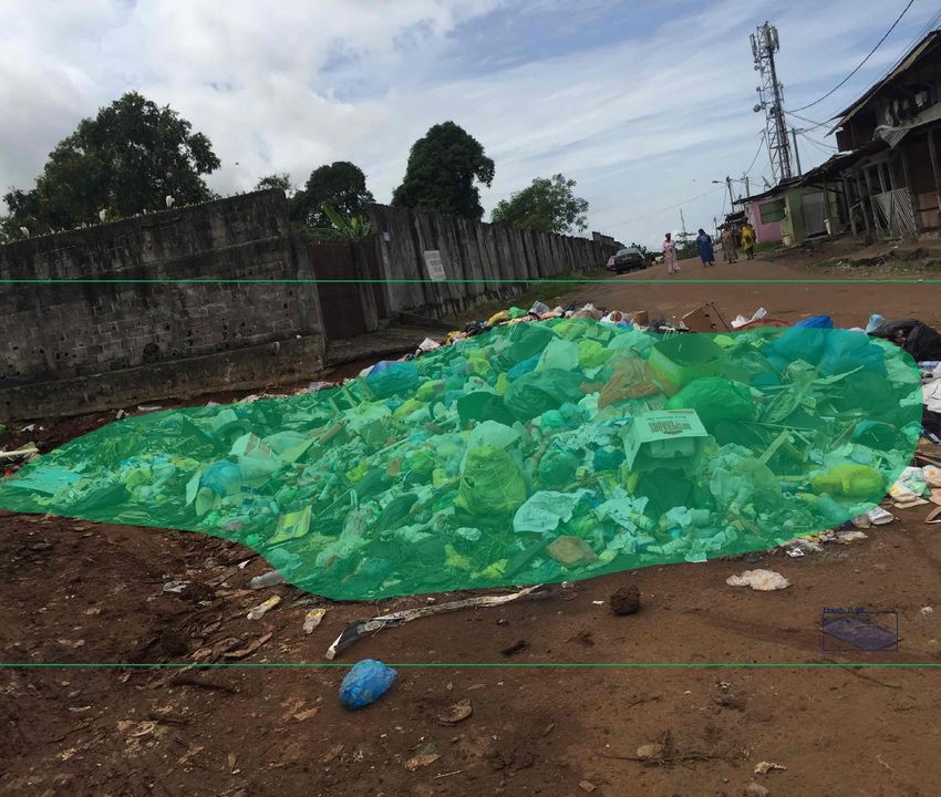
5. Waste Management: Let’s Do It AI – Image-based Waste
Detection..............................................................................26
Background........................................................................... 27
Implementation.....................................................................28
Subsequent Use.....................................................................28
6. Mobility: Thames Valley Berkshire Live Labs – Integrated
Urban Mobility in Berkshire, UK........................................30
Background........................................................................... 31
Implementation.....................................................................32
Subsequent Use..................................................................... 33
Reflection & Recommendations................................................ 35
Glossary.....................................................................................38
Appendix A: List of Interview Partners.....................................40
Appendix B: Interview questions............................................... 37
Image 1: Smart City model, Source: Laremenko, iStock

Executive Summary

Leading tech companies in industrialized countries already             cost vs. benefit and critical points that may arise.
deploy artificial intelligence (AI) applications at scale to improve       In Ho Chi Minh City, Vietnam, AI-powered computer
business practices, administration, environmental protection or        vision based on satellite data supports the city authority to
health services. But also, for low- and middle-income coun-            monitor changes in land use to facilitate integrated urban
tries, AI applications offer a range of new opportunities for          planning processes. In Peru, an AI-assisted system that under-
service providers and governments on all levels. AI-powered            stands text is set up to support the detection of suspicious
approaches can break down existing barriers to human develop-          money laundering transaction to secure public budgets. In
ment and social inclusion and help to achieve the global Sustain-      Großschönau (Austria) and Vilogia (France), an AI-powered
able Development Goals in a more efficient manner. Cities              system monitors and predicts energy and electricity consump-
worldwide are home to many of the key requirements for AI              tion in residential buildings to raise awareness and drive more
innovation, including vibrant ecosystems, data sources and             resource-efficient consumption. In cities all over the world, the
infrastructure. Urban areas are thus ideal places to harness the       CleanWater AI can help detect pollutants on a microscopic scale,
power of AI for sustainable development.                               affordably and in near real-time to improve water supply sys-
                                                                       tems. The Let’s Do It AI technology can provide cities worldwide
In this study, the Deutsche Gesellschaft für Internationale Zusam-     with an AI-powered tool to improve their solid waste manage-
menarbeit (GIZ) GmbH together with the Austrian Institute of           ment operations by automated garbage detection in public
Technology (AIT) examine promising, real-world use cases of            places. Finally, in the UK the Thames Valley Berkshire Live Labs
AI-powered urban development projects in the fields of urban           illustrates how AI-powered systems can improve urban
planning, building management, municipal/public finance,               mobility and integrated planning and operations for multiple
mobility, waste management and water/wastewater. The objec-            positive effects on citizen’s well-being and the environment.
tive is to showcase what AI can already achieve in urban
development today. Going deeper, for each of these pioneer             In the last chapter, we reflect on the success factors of these
projects we provide lessons learnt in terms of the technical           projects and lay out recommendations for using AI applica-
framework employed, their approaches to data, risk and pro-            tions in contexts of integrated sustainable urban development in
ject management, followed by a discussion on transferability,          low- and middle-income countries.
INTRODUCTION

Artificial Intelligence (AI) for
sustainable urban governance
and development

Continued rapid urbanisation is one of the most significant and         In prevailing urban structures, however, resources are managed
influential megatrends of the 21st Century. While covering only         in isolation by different sectoral departments. This has resulted
two percent of the earth’s land surface, cities across the globe are    in inefficient infrastructure systems and land use patterns that
already home to around 56 per cent of the world’s population            fail to utilise economies of scale and waste natural resources.
today. By 2030, they will house two thirds of humanity, rising          Now more than ever, urban decision-makers are recognising the
to more than 70 percent by 2050 (World Bank, 2020: Urban                need for integrated approaches which balance urbanisation, nat-
Development Overview).                                                  ural resource management and socio-economic development and
    Cities are growing at a fast pace and increasingly spreading        enable urban-rural interfaces and sectoral inter-dependencies to
beyond their political and administrative borders. Migratory            be managed in a sustainable way. The German Development
and commuter movements, flows of capital, resources and com-            Cooperation promotes and supports these kinds of integrated
modities as well as soil, air, and water pollution are affecting        urban development processes worldwide, incorporating the four
more and more growing urban areas and their rural surround-             dimensions of inter-sectoral cooperation, multi-stakeholder part-
ings, leading to the emergence of city-regions. Already today,          nership, spatial integration and multi-level governance.
urban agglomerations make up around 80 percent of the global               Another megatrend of the 21st century is the rapid digitalisa-
GDP, consume over 60 percent of global energy, produce 70               tion of all aspects of life as part of the fourth industrial revolu-
percent of global waste and emit 70 percent of all greenhouse           tion. This revolution is being driven above all by artificial intelli-
gas emissions (UN-Habitat, 2016: New Urban Agenda).                     gence (AI). It is also supported by other new technologies that
    At the same time, due to their high population size, density        have grown out of the IT (or third industrial) revolution. This
and location, these areas are particularly exposed to the effects       includes the Internet of Things (IoT), blockchain, robotics, bio-
of climate change and are also drivers for change and innovation.       and nanotechnologies and quantum computing. Thanks to
International agendas such as the 2030 Agenda for Sustainable           increased computing power, breakthroughs in research and an
Development and the Paris Agreement recognise the important             ever-growing pool of data, AI technologies continue to develop
role of cities. In fact, two thirds of all Sustainable Development      at an impressive pace. Large quantities of data, computing
Goals (SDGs) can only be achieved in and with the help of cit-          power and digital innovation ecosystems are concentrated in cit-
ies.                                                                    ies in particular, alongside the kinds of problems that these tech-
   There is an urgent need for new and improved infrastructures         nologies can help to solve. As such, cities across the world will
and services due to the extent of urban demands coupled with            have a vital role to play in ensuring sustainable development and
environmental degeneration and our changing climate. Govern-            human-centric digitalisation.
ment institutions, especially at local level, face the challenges of:       Cities have become increasingly digitalized over the past dec-
                                                                        ades due to major advancements in digital technologies. At the
•   providing a growing urban population with access to basic           same time, new methods have been developed that offer detailed
    services and vital resources,                                       insights and opportunities for investigating, planning and man-
•   sustaining continuous economic development and                      aging cities. Cities and their decision-makers (as the closest level
•   managing resource consumption to within the earth’s capac-          of government for citizens) have a great responsibility to ensure
    ity while addressing the challenges of climate change.              digitalization is human centric and develops in the interest of

                                                                                                                                            5
the common good. Digital approaches also open up opportuni- showcase what AI can already achieve in urban development
ties for finding answers to climate change and supporting more today and to find out what lessons can be learned from pioneer
sustainable development in line with the 2030 Agenda. projects in terms of management structure, technical require-
Artificial intelligence (AI) in particular has become increas- ments and cooperative implementation. For AI to make a posi-
ingly more widespread in cities. From monitoring land use and tive contribution, it is vitally important that a) AI is used in line
detecting pollutants in urban environments and infrastructures with local requirements; b) barriers to entry for the population
through predicting household energy consumption and promot- as a whole as well as research and businesses are lowered; and c)
ing resource efficiency, AI applications open up promising datasets and algorithms are transparent and civil liberties and
opportunities and can also be used to deal with complex social human rights play a central role. The German Development
and environmental interrelationships. However, integrating and Cooperation is eager to promote and scale the benefits of AI
intersecting different domains in AI applications is still a chal- technologies for good urban governance in order to drive sus-
lenge. Properly used, AI applications have the potential to make tainable urban development and help its partners localise
a significant contribution to integrated urban development in Agenda 2030 and the Paris Agreement worldwide. To achieve
future. this, new partnerships and new forms of cooperation and co-cre-
For this study, the Deutsche Gesellschaft für Internationale ation are needed. This publication is intended to initiate dis-
Zusammenarbeit (GIZ) GmbH partnered with the Austrian Insti- course on these partnerships and the accompanying technical
tute of Technology (AIT) to examine promising, real-world use and ethical challenges.
cases of AI-driven urban development projects in the fields of
urban planning, construction, municipal finance, mobility,
waste management and water/wastewater. The objective is to
Four dimensions of the integrated urban development approach:
Integration of a variety of strategic urban sectors and services, for instance
coupling municipal solid waste management with climate-friendly energy
production, or applying a holistic approach to the development of solutions at
the interface of energy, mobility, architecture and ICT.
Integration of relevant actors and stakeholders, i.e. supporting not only citizen
participation and involvement of civil society organisations, but also bringing
together different authorities, experts of different disciplines, actors from the
private sector or integrating research institutions into strategic collaborations.
Integration of different spatial areas, i.e. establishing cooperation among
neighbouring municipalities, strengthening linkages between urban, peri-urban
and rural areas, and creating governance structures at a metropolitan level for
intermunicipal coordination and joint delivery of public services such as public
transport services.
Integration of different government levels for the implementation of measures to
align local activities, strategies and policies with the ones at the regional and
national level, to pursue t he dialogue between different government levels in
both directions, and finally, to transfer experiences and good practices between
government levels for replication and integration in respective policies and
plans.
6
Methodology

For this study, a desk research identified 18 urban AI use cases     Interviews
corresponding to six predefined topics of sustainable urban
development. Based on this selection, six use cases were short-      A series of six interviews were conducted with contact persons
listed for in-depth analysis (see table 1 below). This includes      who were ready to share information on their use case. Each
interviews with the key project stakeholders.                        interview followed a semi-structured pattern (see list of questions
                                                                     in Annex B). This approach allowed us to gain insights into the
                                                                     guiding questions complemented by additional information. The
Selection process and shortlisting                                   interviews were conducted in Spring 2020 via Skype and took
                                                                     one hour. They were recorded and the answers are summarized
To obtain a general overview of the latest AI implementations in     in the following chapters of this report.
the urban domain, an initial stage of desk research was carried
out using the internet, literature and scientific papers in Spring
2020 to identify use cases for each predefined topic of interest
(urban planning, finance, building, water/wastewater, waste
management, mobility). The selection process was guided by the
following principles:

• Project location: Aiming for a wide spread of projects across
  the world
• Readiness: Aiming for a high level of implementation readiness
• Ability to support SDGs, including:
  – Universality
  – Leaving no one behind
  – Interconnectedness and Indivisibility
  – Inclusiveness
  – Multi-stakeholder partnerships
• Dimensions of an integrated approach towards sustainable
  urban development, such as:
  – Multi-stakeholder cooperation
  – Inter-sectoral approach
  – Multi-level governance
  – Intercommunal cooperation
• Existing contact with project leaders/experts

Three use cases were identified for each of the six topics. These
18 use cases were then reviewed and evaluated in line with the
above principles to identify one use case per topic that could
then be shortlisted for in-depth research in the next step.

                                                                                                                                      7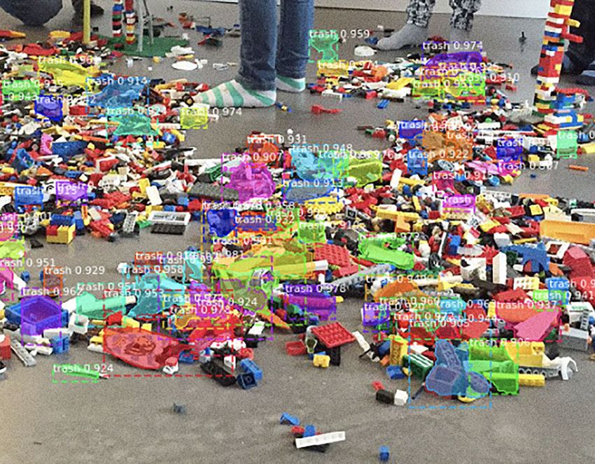
Short-listed urban AI use cases
    Topic            Title                      Country/Region      Main Partners                 Technology

    Urban Planning   AI for Earth Land Cover    Vietnam / Asia      •   Ho Chi Minh City          Satellite image
                     Mapping                                        •   World Bank                processing
                                                                    •   Microsoft
                                                                    •   Planet
                                                                    •   Airbus
                                                                    •   VLAB
                                                                    •   Singapore-ETH Centre

    Financing        AI assisted Detection of   Peru / South        • Financial Investigation     Natural language
                     suspicious Money           America               Unit (FIU)of Peru           processing
                     Laundering Transactions                        • GIZ
                     in Peru                                        • Technical University of
                                                                      Peru

    Building         inBetween                  Austria, France /   • Austrian Institute of       Convolutional
                                                Europe                Technology (AIT)            neural network
                                                                    • Rina
                                                                    • PUPIN
                                                                    • Acciona
                                                                    • Develco

    Water &          Clean Water AI                                 • Clean Water AI              Image processing
    Wastewater

    Waste            Let’s Do It AI                                 • Let’s Do It Foundation      Image processing
    Management                                                      • Microsoft

    Mobility         Thames Valley Berkshire    Reading, UK /       •   O2 / Telefonica           Computer vision
                     Live Labs                  Europe              •   Siemens
                                                                    •   WAYRA
                                                                    •   Smarter Grid Solutions
                                                                    •   Reading Borough Council
                                                                    •   Slough Borough Council
                                                                    •   University of Reading:
                                                                    •   Multiple start-ups

8
Open
 Standard        Maturity Level1             Contribution to SDGs         2030 Agenda Principles      Integrated Approach

  Yes / no        TRL 7 – System              • 11: Sustainable Cities    • Universality              • Multi-stakeholder
                  prototype                     and Communities,          • Leaving no one behind       cooperation
                  demonstrated in             • 13: Climate Action        • Interconnectedness and    • Inter-sectoral approach
                  an operational              • 15: Life on Land            Indivisibility
                  environment                 • 16 Peace, Justice and     • Inclusiveness
                                                Strong Institutions       • Multi-stakeholder
                                                                            partnerships

  No              TRL 7 – System              • 16: Peace, Justice and    • Universality              • Inter-sectoral approach
                  prototype                     Strong Institutions       • Leaving no one behind     • Multi-level governance
                  demonstrated in             • 17: Partnership for the   • Inclusiveness
                  an operational                Goals
                  environment

  No              TRL 5 –                     • 7 Affordable Energy       •   Universality            • Multi-stakeholder
                  technology                  • 9: Industry, Innovation   •   Leaving no one behind     cooperation
                  demonstrated in a             and Infrastructure        •   Inclusiveness           • Inter-sectoral approach
                  relevant                    • 11: Sustainable Cities    •   Multi-stakeholder       • Inter-communal
                  environment                   and Communities               partnerships              cooperation
                                              • 12: Responsible
                                                Consumption

  Yes             TRL 6 –                     • 3: Good Health and        • Universality              • Multi-stakeholder
                  Technology                    Well-being                • Leaving no one behind       cooperation
                  demonstrated in a           • 6: Water and Sanitation   • Interconnectedness and    • Inter-sectoral approach
                  relevant                    • 9: Industry, Innovation     Indivisibility            • Multi-level governance
                  environment                   and Infrastructure        • Inclusiveness             • Inter-communal
                                              • 11: Sustainable Cities    • Multi-stakeholder           cooperation
                                                and Communities             partnerships

  Yes             TRL 6 –                     • 3: Good Health and        • Universality              • Multi-stakeholder
                  Technology                    Well-being                • Leaving no one behind       cooperation
                  demonstrated in a           • 9: Industry, Innovation   • Interconnectedness and    • Inter-sectoral approach
                  relevant                      and Infrastructure          Indivisibility            • Multi-level governance
                  environment                 • 11: Sustainable Cities    • Inclusiveness             • Inter-communal
                                                and Communities           • Multi-stakeholder           cooperation
                                                                            partnerships

  Yes             TRL 5 –                     • 3: Good Health and        • Leaving no one behind     • Multi-stakeholder
                  Technology                    Well-being                • Interconnectedness and      cooperation
                  demonstrated in a           • 7: Affordable and Clean     Indivisibility            • Inter-sectoral approach
                  relevant                      Energy                    • Inclusiveness             • Multi-level governance
                  environment                 • 9: Industry, Innovation   • Multi-stakeholder         • Inter-communal
                                                and Infrastructure          partnerships                cooperation
                                              • 11: Sustainable Cities
                                                and Communities

Table 1: Shortlisted six use cases depicted in this study background

1		 TRL = Technology readiness level

                                                                                                                                  9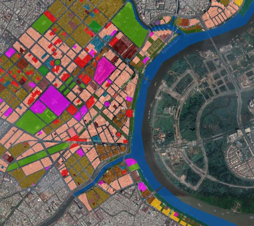
Image 2: Web interface of the AI for Earth Land Cover
Mapping tool, Source: Ho Chi Minh City

HIGHLIGHTS

• Online platform that uses AI to monitor changes in land use

• Time-efficient information-gathering process based on satellite imagery

• Bringing stakeholders closer to the local authorities and the city’s planning process

10
1. URBAN PLANNING

AI for Earth Land Cover
Mapping – Land use planning in
Ho Chi Minh City, Vietnam

Background                                                              The project is led by the Ho Chi Minh City Planning Depart-
                                                                        ment and the World Bank. Further partners include:
AI for Earth Land Cover Mapping is an innovative, user-centric
artificial intelligence (AI) tool developed for the Ho Chi Minh         • Microsoft AI (company): Technical implementation and deliv-
City (HCMC) Planning Department in Vietnam. It helps urban                ery of the Microsoft AI tool
planners make decisions aimed at tackling the city’s rapidly            • Planet (company): Satellite imagery delivery and tool engi-
expanding key challenges related to traffic, infrastructure, envi-        neering
ronment, uncontrolled investments and new developments. In              • Airbus (company): Satellite imagery delivery
the past, the city’s data and information was fragmented, inacces-      • VLAB (start-up company, Vietnam): Innovative urban plan-
sible and sometimes outdated. This resulted in a lack of planning         ning solutions
cohesion for the city government and its stakeholders. AI for           • Singapore-ETH Centre (Campus for Research Excellence and
Earth Land Cover Mapping aims to solve this problem.                      Technological Enterprise): Technical work delivery
    The HCMC Urban Planning Platform was developed as a first
step to help the city face up to its challenges and to help local       The platform’s AI processes satellite images from different time
government take informed spatial planning decisions. The plat-          periods based on the customer’s needs and the availability of sat-
form increases efficiency levels by digitalizing urban planning         ellite images. It then delivers detailed information about the land
processes for the city. It uses remote sensing techniques to detect     coverage and functionality of an area. Comparisons can be made
and classify objects from satellite images. It then vectorises the      on an annual, quarterly or monthly basis to monitor changes in
extracted data and stores it in a way that is accessible to everyone.   the urban footprint, validate claims by the public, approve devel-
Users can also provide feedback on the datasets.                        opment requests and prevent uncontrolled urban sprawl and
    The HCMC Urban Planning Platform is currently being                 investments that conflict with local legislative policy. This results
enriched using artificial intelligence and deep learning technolo-      in a more transparent and efficient exchange of information
gies to create an ‘AI for Earth Land Cover Mapping tool’. The           regarding issues such as permissions, land use coverage, potential
main goal here is to provide stakeholders with a tool that can be       environmental risks for an area or current and future develop-
used to interactively classify land cover types from satellite          ments. This intuitive, user-centric and web-based tool allows
imagery, provide automatic updates and maintenance processes as         public and private stakeholders to interact more closely with local
well as systematically and efficiently update data.                     authorities and the city’s planning processes.

                                                                                                                                          11
The project supports the following Sustainable Development not limited to RGB channels). While higher-resolution
Goals (SDGs): images enable more details to be detected in land cover anal-
ysis, they also take more time to display and are more expen-
1. SDG 11 “Sustainable Cities and Communities”: By making sive to obtain. According to the project officer a model that is
urbanization more inclusive and sustainable and reducing the run on 0.5 m resolution imagery will take nine times longer
adverse effects of natural disasters, for example by reducing to classify than a model run on 1.5 m resolution imagery. It
buildings’ exposure to flood risk. should be noted that in the case of HCMC, the local climate
2. SDG 13 “Climate Action”: By strengthening resilience to cli- conditions (for example the rainy season in the HCMC area)
mate-related hazards. can have a major impact on the quality of the imagery gath-
3. SDG 15 “Life on Land”: By focusing on ecology and preserv- ered.
ing ecosystems, the project can inform stakeholders about
existing ecosystems, the location of forests and degraded land
and by doing so, help prevent the uncontrolled destruction of Data management
land in Vietnam.
4. SDG 16 “Peace, Justice and Strong Institutions”: By ensuring Personal data is not used at any stage in the project. The
public access to information and protecting fundamental high-resolution satellite imagery is currently provided by Planet
freedoms. and Airbus, and data outlines that make commercial imagery
accessible must be provided. The images are not collected in tiles
but are captured based on the geographical boundary of the
Implementation region in question. Images must be completely cloud-free.
Data is stored in the cloud. This means that there is no need
Currently, the project is being developed for the Nhà Bè district for the local authority to store the imagery on a separate web
in Ho Chi Minh City. The district covers an area of 100 km2 server. This reflects the project’s aim to deliver a service that
and is home to over 100,000 inhabitants.It is one of the most always uses the latest available satellite images. Currently, the
rapidly developing districts of HCMC. The project’s next step is team is also developing a set of APIs that will allow the project
to find a way to access application programming interfaces to be scaled up to cover the whole of Vietnam.
(APIs) that will allow authorised users to access data and exter-
nal software components. This would enable the project organiz-
ers to scale up the project for the entire country and combine it Risk management
with other settings.
Depending on the climatological conditions of the area in focus,
for example if it is the rainy season in Ho Chi Minh City, there
Technical framework is a technical risk that images may take longer to be created. It
took a month, for example, to collect a previous set of images
Due to the limitations of the lower-resolution Sentinel imagery from the rainy season. However, this risk should not be borne by
initially taken from the Google Earth Engine, an independent a local government, which means that the standards for imagery
and automated tool had to be developed to meet the project’s delivered by a satellite company must be defined beforehand.
requirements. The AI for Earth Cover Mapping tool is based on Base images that cost an estimated price of €100, for example,
a customised deep learning model that uses different kinds of should be less than six months old and have less than five per-
satellite imagery (tested using free low- (Sentinel-2) and medi- cent cloud coverage.
um- (SPOT 6-7) resolution imagery as well as very high resolu- In terms of usage and in light of the many different stake-
tion imagery subject to a fee (Pleiades 0.5 m)). The technical holders involved, there is also a risk of the method being mis-
process can be summarised in following three core parts: used to benefit parties involved in the project, such as real estate
developers. The involvement of an external partner – in this
1. A web interface – Developed as an interactive web platform, instance the World Bank – helps minimize this risk and ensure
the interface allows users to directly check their model’s pre- the approach remains independent.
dictions. It also highlights errors. New land use classes can be
created and similar areas can be selected on the satellite
images to provide new training points for the AI model. Governance & project management
2. A deep learning model – Based on a convolutional neural
network (a class mostly applied to analyse visual imagery), The project is organized in a top-down structure between the
the model uses unsupervised feature-learning on satellite city government, technology companies, start-ups and academia.
images without labelled data for initial training. It allows ele- Ho Chi Minh City and the World Bank are the project leaders
ments that belong to different categories to be identified, of the AI for Earth Land Cover mapping project. They meet on a
including infrastructure networks, natural objects (such as weekly basis with the key partners Microsoft AI, Planet and Air-
rivers and lakes) and buildings. It can also detect if their col- bus plus representatives from three HCMC departments (the
ours, textures and patterns change. Department of Planning and Architecture, the Department of
3. Satellite images – The platform can be used for both visualis- Transportation and the Department of Construction) to define
ation and classification purposes. It is does not depend on a the next steps. The chairman of the political party is updated
specific source of satellite images or their resolution (it is also quarterly or every six months.
12Subsequent use The project is scalable and provides several benefits to users
that clearly exceed the overall project costs. These can be sum-
Setting clear and realistic expectations on how AI technology marized as follows:
can help in a specific area of interest such as urban planning is
one of the key criteria for the success of the Ho Chi Minh use 1. Improved monitoring – Gathering information and expos-
case. For the HCMC use case, artificial intelligence and disrup- ing urban changes such as the growth of the city’s urban
tive technologies in general are characterised by three dimen- footprint or changes in land use patterns.
sions – capability, complexity and cost: 2. Improved management – Addressing and detecting issues
such as informal land growth, buildings’ exposure to envi-
1. Capability – Results do not have to be perfect, but they should ronmental risks and green areas that have been replaced by
be ‘good enough’. Instead of spending years producing a topo- new, unplanned developments.
graphic land use classification map, AI technology can deliver 3. Informed decision making – Taking informed action, such
results in a much shorter time and as a scalable product. The as adapting tax administration or establishing measures to
ability to overlay a regional border is also very important as prevent environmental risks.
this allows data to be displayed by area and not by imagery
tile2 . Being able to export information for two different time Combining additional information such as tax administration
periods is another key factor as it allows users to compare them information with the satellite imagery will enable the model to
and see if there has been a change in land use. be expanded to other domains outside of planning. This will
2. Complexity – Even the most sophisticated AI model will not allow it to be used by authorities, for example, to determine
be of any use if it does not come with a simple user interface the number of staff they will need in future.
or documentation. The final goal is to create a user-friendly tool that provides a
3. Costs – An affordable technology infrastructure is the key to large amount of information in a less complex way. The sus-
success. In this case, for example, the resources are provided tainable business model is based on an annual subscription,
by Microsoft AI. A transparent overview of costs and know- which will reduce costs and make it more affordable and acces-
ing the total cost per satellite imagery for the time period in sible for local authorities. As accessibility to useful satellite
question are equally important. images is key to the tool’s sustainability and long-term success,
supply agreements between image providers and governments
will be established.
Transferability
The AI for Earth Land Cover Mapping project is characterised Critical perspective
by its scalability. Developed initially for one district of HCMC,
plans are already underway to expand it for all of Vietnam. Later • Transparency – While the existing Urban Planning Plat-
on, it will be possible to reproduce the project in other places form is mostly citizen-centred, the AI for Earth Cover Map-
around the world because it uses Microsoft AI and Sentinel sat- ping tool is built primarily to enable local government and
ellite tiles. In the case of densely populated areas such as the planning department to make informed decisions. Giv-
HCMC, however, georeferenced data with a higher granularity ing users access to land use coverage information means
than Sentinel might be needed. This will have to be evaluated that it will be possible to create overlays showing additional
beforehand. information. This will enable feedback loops and also
Besides the technological innovation itself, public and proce- increase the chances of attracting more investors to HCMC
dural engagement are crucial elements to the overall success of by making information more transparent, with English
the approach. This includes factors such as the legal framework translations for international investors.
for data sharing and access practises that might differ from • Technological independence – Although the national gov-
country to country. ernment has access to high-resolution imagery, local govern-
ment does not. The World Bank and HCMC are working
together on this simple-to-use AI tool to help tackle this
Cost benefit & business model ongoing challenge. Allowing stakeholders to own the appli-
cation will put pressure on central government to demand
As the project is still in its development stage, the cost calcula- higher resolution images: Initially by implementing free
tion has not yet been finalized. Based on ongoing development imagery to show the potential of the application, and then
and findings, however, costs will be closely linked to the chosen by using better, more expensive imagery with a higher reso-
setting and quality of the images. While lower-resolution image- lution.
ry is available for free (and suitable for rural and less dense • Environment – The AI for Earth Cover Mapping project
urbanised areas), high-resolution imagery is subject to a fee. focuses primarily on flood risk as the tool’s main aim is to
control areas that are or could be affected by floods.
• Political interests – It is crucial that the benefits and
2 An imagery tile is a satellite image that is part of a bigger satellite image value of the project are interesting at a political level and
tile set. The bigger set of image tiles is taken by satellites in a row in or- not just in terms of monetary value but also politically.
der to cover a larger area of the earth and achieve the highest resolution Hence, its outcome and resulting decisions are of political
possible. Satellite images are usually sold as individual tiles. interest.
13Image 3: Animated AI supported grafical user interface, Source: Metamorworks, iStock HIGHLIGHTS • Structuring of unstructured STR information to improve detection of illegal financial transactions by using AI • AI text processing methodology • Sorting suspicious transactions based on structuring and prioritisation to assist human analysts in financial authorities and to streamline and increase the efficiency of transaction processing 14
2. FINANCING

AI-assisted detection of
suspicious money laundering
transactions in Peru

Background                                                             This project primarily supports two Sustainable Development
                                                                       Goals (SDGs):
Tracking and detecting illegal income is a massive challenge all
over the world, but especially in developing countries. Any mon-       1. SDG 16 “Peace, Justice and Strong Institutions” – Peru is one
ey transactions that raises the suspicion of being made to hide or        of the three biggest coca plant cultivating countries. The
launder the proceeds of crime must be reported. This includes             majority of the coca is used by cartels to manufacture drugs,
transactions for buying a house, withdrawing larger amounts of            and the income generated from this business is laundered via
money or exchanging currencies. Banks, notaries, lawyers and              various channels. AI will enable the FIU to detect these more
other reporting entities are obliged to share their suspicious            efficiently.
transaction reports with so-called financial intelligence units        2. SDG 17 “Partnerships for the Goals” – The project will
(FIUs). Currently, these reports are processed and analysed man-          improve the country’s domestic capacity for collecting taxes,
ually by employees of the FIUs. Another aspect is that invest-            enabling it to strengthen its financial resources for develop-
ments in cities that are driven by money-laundering considera-            ment projects. The FIU can share knowledge with compara-
tions rather than economic considerations would decrease (dis-            ble units in other countries.
torts prices for real estate and urban planning).
    In Peru, suspicious transaction reports (STRs) are addressed to
the country’s Financial Investigation Unit (FIU). The FIU staff has    Implementation
to read the reports, analyse and prioritize them. Cases representing
a potential crime are sent to the prosecutor’s office. The number of   Technical framework
these STRs is continually increasing, for example from around
2,000 in 2011 to over 15,000 reports in 2018. This means that the      The project started in 2019 and will finish in 2021. It is impor-
FIU has limited staff to process the growing number of STRs. It is     tant to mention the participation of the academy in the realiza-
assumed that an AI-assisted process could improve the FIU’s capac-     tion of the project. The technical knowledge about AI was incor-
ity to analyse reports. It would also enable the FIU to cope with an   porated into the project by contracting the Research Institute of
even higher number of STRs in future. The objective of the project     the Technical University of Peru to provide the service of
is to develop an AI-based assistance system that allows the FIU to     designing and implementing the AI model for the identification
structure unstructured information from the STRs.                      of the relevant data extracted from the STR. A natural language

                                                                                                                                     15
processing method has been applied to perform unstructured Subsequent use
information processing to facilitate further analysis and prioriti-
zation of the STRs. The technical implementation was led by
the Technical University of Peru and involved two AI scientists. Transferability
Labelled datasets had to be created to train the machine learning
models. This first step was carried out by humans, who classified Based on international standards, most countries worldwide
raw textual data that enabled the AI algorithm to automatically have similar processes for reporting suspicious money flows. The
learn how to identify new information. Manually labelling the text processing system embedded in this project can be directly
training dataset took over three months. As a project partner, transferred to other Spanish-speaking countries and adjusted to
GIZ provided technical support and assistance for dataset label- any local language in non-Spanish-speaking countries. The sys-
ling and hired two consultants with experience in machine tem might have to be retrained for non-Spanish-speaking
learning who supported the technical development. As most of regions. The resulting increase in tax income can be used by cit-
the STRs have unstructured text data, machine learning meth- ies to fund urban development projects, make them more sus-
ods were used to process the data and obtain useful information. tainable and improve quality of life. It could also be used to
A recurrent neural network was applied for natural language expand local/municipal revenue management.
processing (NLP) using an attention mechanism – in particular,
Tensorflow and Genism python packages – and the Spanish
word2vec representation of the Spanish vocabulary was used. Cost-benefit & business model
The material costs of the project were under €10,000. This
Data management included the purchase of two computers with strong graphics
cards (for training NLP models). The cost of designing and
According to anti-money laundering standards, many institu- implementing the AI model was under €25,000. This low
tions and economic stakeholders are required to report suspi- amount was due to the fact that the Research Institute of the
cious transactions to the FIU. The list of reporting entities Technical University of Peru is a non-profit agency, which
includes banks, car dealers, real estate companies, currency allowed the establishment of a cooperative relationship between
exchange offices and notaries, all of whom use different criteria public actors (University and FIU) with the technical assistance
to classify transactions as suspicious. When a suspicious transac- of the German Cooperation. The AI-supported system described
tion is detected, they complete the above-mentioned suspicious here improves efficiency and accuracy by automating the scan-
transaction report (STR). This includes a manually written sec- ning of STRs and reducing the amount of human labour
tion that describes the details of the transaction and the reason required for this process.
why the reporting entity suspected an illegal act. The STRs are
then transmitted to the FIU, where employees read them and
decide on the level/priority of suspicion. In the event of strong Critical perspective
suspicion, employees elaborate a financial intelligence report ad
forward the case to prosecution. All data is highly confidential • The project shown here is still in the development phase. The
and only FIU and state institutions have access to it. first prototype of the system is scheduled to be ready in
beginning of 2021 and will be tested afterwards. The proof of
concept can only be evaluated during 2021. The sensitivity
Risk management and accuracy of this system can only be evaluated when there
is an existing prototype, and the viability of the proposed
STRs contain extremely sensitive information about the individ- procedure can only be determined based on these perfor-
uals involved in the transaction and so they are treated in a mance indicators.
highly confidential way: STR datasets are only available on com- • The STR documents are highly confidential. The risk of
puters inside the FIU office and these are physically disconnect- potential leaks is high as the method of questioning employ-
ed from the internet. Each developer works in this office and is ees using a polygraph is not 100 percent reliable.
not allowed to copy any data to an external storage device. A
polygraph test is performed on everyone twice a year to prevent
any sensitive information from the FIU being leaked.
Governance and project management
Working as technology partners, GIZ and the Technical Univer-
sity of Peru developed the AI for the Financial Investigation
Unit (FIU). The FIU employees must be trained to use this sys-
tem. During an initial phase, the university researchers provided
low-cost support to the FIU operators. Once the initiation phase
is over and the project has been concluded, the management and
governance of the tool will be handed over to the FIU.
16OBLIGATED FIU
PERSONS
Storage of STR AI Analysis Priorisation Post Analysis
STR Registry
Processing / Processing / Analysis
Structured
Comple-
mentary
Information
Analyst New Data Analyst
More Data
Unstructured Structured
Image 4: Proposed scheme for the treatment of suspicious financial transactions, Source: FIU & GIZ Peru
17Image 5: Smart Home animation, Source AH Fotobox, iStock HIGHLIGHTS • Using AI to monitor and predict energy and electricity consumption in residential buildings. • An automatic data collecting system can be installed in any building, whether a new build or older property. • Inhabitants are informed of their electricity consumption, raising their awareness and prompting them to implement energy-saving measures. • Provides a consumption prediction for electricity grid providers. • Detects failures in building installations as well as heating, ventilation and air conditioning (HVAC) systems. 18
3. BUILDING

inBetween - Monitoring,
analysing & nudging towards
energy efficiency

Background                                                                             The name of the inBetween project is an acronym for
                                                                                   “ICT-enabled BEhavioral change ToWards Energy EfficieNt life-
Nowadays, we spend more than 80 percent of our lives within                        styles”. It was funded by the European Horizon 2020 fund and
buildings. At the same time, households represent around 30 per-                   focused on how to use information technology to investigate
cent of the total energy consumption, with electricity consumption                 energy-efficient residential lifestyles. The project monitored and
often higher than necessary. Making residents aware of this by ana-                analysed energy consumption behaviour inside residential build-
lysing their consumption patterns and providing them with feed-                    ings and predicted possible energy use as well as energy-saving
back therefore has the potential to generate significant energy sav-               potential. According to the project report, “the main motivation
ings: Informing electricity users about their energy consumption                   for such development is that more than 30% of the world’s electric-
can trigger important psychological processes that can cause people                ity can be attributed to the residential and commercial buildings
to adjust their lifestyle and consumption preferences3 (for example                […] this figure can be reduced by up to 12% by only giving feed-
by using energy-efficient vacuum cleaners or efficient light-emitting              back to the customers on ways in which they consume their energy
diodes (LEDs) instead of light bulbs, turning off espresso machines                on an appliance level.”4
when not in use or using an eco-program on the washing machine).
    At the same time, from an operator’s perspective, predicting                   Project partners included:
electricity consumption is a vital for operating smart grids, espe-
cially when power is drawn from renewable power plants that                        • AIT Austrian Institute of Technology (research and technol-
are highly dependent on the weather. Thanks to recent develop-                       ogy organization responsible for data mining and evaluation)
ments in IoT (Internet of Things) devices and the current state                    • Rina (private company responsible for integrating middle-
of data processing technologies, we can now precisely monitor                        ware, platform architecture and project coordination)
and analyse electricity consumption and predict electrical energy                  • PUPIN (R&D institute responsible for mobile application
consumption using state of the art data-mining methods.                              deployment and middleware)

3		For an literature overview see: Dosmukhambetova, D. (2020). The use of be-      4		Cited from inBetween’s non-public 1st Period Project Report. A sum-
   havioural insights in promoting residential energy efficiency: an overview of      mary of this internal project report can be found on the EC’s Cordis
   available literature. Auckland Council technical report, TR2020/015                website

                                                                                                                                                       19
• Acciona (private company responsible for developing the vis- do this, the clustering algorithm was initially developed using
ualization platform) publicly available household data as well as Birch and
• Develco (private IoT company that develops smart home K-means clustering algorithms.
devices and sensors: smart meters, smart cables, motion sen- 3. Correlation analysis – In a next step, the defined clusters were
sors, window sensors and volatile organic compound (VOC) correlated with variables based on environmental (weather),
sensors). social (number of occupants), financial (electricity prices) and
temporal (calendar) characteristics and the outcome was
The AIT Austrian Institute of Technology was responsible for included in the profile categorization. This allows the opera-
evaluating data from smart electricity meters and sensors. tor (energy manager/energy advisor) to understand consump-
Together with the project partners, the institute set up a data- tion and generate recommendations targeted at specific user
base to store sensor data collected at 15-minute intervals. The groups.
AIT team mined the sensor data gathered and developed
machine learning models to classify usage patterns and predict The project uses various Python packages for analysis purposes.
electricity consumption. Specifically, Python implementations of the scikit-learn package
and other Python packages (for example, pandas for handling
The project supports the following Sustainable Development time-series data) are used for the supervised and unsupervised
Goals (SDGs): learning algorithms.
With regard to forecasting time series, the Python analysis
1. SDG 7 “Affordable and Clean Energy”: This project aims to packages (pandas, NumPy etc.) were implemented to create fea-
make households more energy efficient. tures for testing various regression algorithms (support vector
2. SDG 9 "Industry, Innovation and Infrastructure": Enhancing machines, ElasticNet, kernel ridge regression). A cross-validation
technology and access to information for improved services approach was used to tune the hyperparameters. The resulting
and infrastructure. prediction model was delivered as a Python package and
3. SDG 11 "Sustainable Cities and Communities": The project deployed on a prediction server, which allows the prediction
promotes sustainable urbanisation and reduces costs for basic process to be triggered on demand.
services. On the application development end, a consumption data
4. SDG 12 “Responsible Consumption”: The project promotes analytics module based on a convolutional neural network was
the development of technology that makes building residents implemented for disaggregating electricity loads (as a special task
aware of their exact electricity consumption, and thus con- for non-intrusive load monitoring (NILM)) together with an
tributes to the more responsible consumption of energy alarming system that instantly reports operational building fail-
resources. ures to facility managers. This allows facility managers to recog-
nize and rapidly resolve failures that could otherwise result in
serious and costly damage if left undetected.
Implementation Furthermore, to make the solution more transferrable and
generalized, an ontology was developed as a dictionary of meta-
The project was implemented in two residential districts – one data fitted to the building information modelling.
in Großschönau, Austria and one in Vilogia, France.
Data management
Technical framework
Smart sensors were installed in apartments and data was collect-
The development of the project can be broken down into follow- ed in 15-minute intervals. All of this data was stored in a central
ing three main topics: database that could be accessed by the project partners.
The data sharing agreement between the residents and the
1. Data – Multiple IoT sensors were placed in individual apart- companies had to comply with the European General Data Pro-
ments inside the residential buildings. These sensors were tection Regulation (GDPR) framework. This gave the individu-
used to collect the requisite data (including temperature, als the option to opt out at any time and also ensured that their
humidity, air quality, door and window sensors, energy meter data was kept securely. Besides this, a standard level of data
data) every 15 minutes with a granularity level based on the management for exchanging, accessing, managing and integrat-
findings of preliminary data analysis. Publicly available ing data was used. The development of personal data handling
weather data was also used together with proprietary data on processes slowed down the development process.
individual apartments, which was collected over a three-year
period and stored in a secured database.
2. Clustering – Data clusters of consumption profiles were Risk management
defined based on the time series. These were then used to cat-
egorize consumers. This step allowed more accurate forecast- To ensure the project complied with the privacy requirements of
ing techniques to be applied based on classical machine GDPR, the data was actively anonymised before being stored.
learning algorithms. The user profiling service is used to bun- For mitigation of data privacy risks, governance approaches for
dle users (apartment occupants, occupants of public/office data access rights were discussed with residents and later devel-
buildings) and their consumption behaviour into groups. To oped.
20Governance & project management budget IoT devices and DIY, we can assume that costs can be
kept at a minimum. The project results provide multiple benefits:
To ensure data was handled appropriately, a partner deployed a
local compute server instead of a cloud solution. The safeguards • Providing feedback to residents about their exact consump-
for data safety included authentication methods, passwords and tion tends to lead to more efficient consumption.
the removal of personal data in the pseudo-anonymised dataset. • Continuously monitoring electricity consumption and detect-
The residents had access rights to their own consumption data in ing faults in electric appliances leads to lower building/facility
the mobile app. maintenance costs.
• Predicting the electricity consumption of buildings and dis-
tricts provides huge benefits to electricity grid operators as it
Subsequent use enables them to more effectively adjust energy production at
power plants.
Transferability
Critical perspective
The monitoring and prediction system built for this project is
flexible and can be easily transferred to other residential and • Data privacy – The incorrect implementation of data privacy
commercial buildings worldwide. The system can be installed in and encryption measures could lead to the potential misuse
new builds and older buildings, and the requisite sensors can be of electricity usage data
installed in apartments. They do not have to be installed in all • Efficiency – Statistical data would not provide many benefits
apartments. If inhabitants do not agree for privacy reasons, their in apartments where electricity use is already very low (for
apartments can be excluded. This may lead to challenges with example in apartments where there are only a few electrical
regard to acceptance in different cultures: Austria and France, devices or where the inhabitants already use highly efficient
for example, are two highly developed countries. These tech-aff- appliances). The cost of installation and the benefits from
ine cultures offer excellent conditions for this kind of applica- potential energy savings should therefore be evaluated. Here,
tion. Acceptance levels in emerging and developing countries, we would suggest pre-screening apartments to ensure maxi-
however, might be lower due to different cultural backgrounds. mum effectiveness.
This needs to be investigated further. • Framework/environmental conditions – The system described
here is viable in places and municipalities where there are
Potential stakeholders in the results of the project include: existing, stable internet networks as well as facility manage-
ment services and existing expertise for installing the devices.
• Technology providers for smart home devices and home auto- • Efficiency assessment – Long-term data collection and evalua-
mation systems tion would be required to assess the exact consumption
• Governments and policymakers: The vast amount of real data reductions that could be achieved with this system. This
will enable them to make better decisions information is currently not available.
• Social housing associations: These organizations are keen to • Resident engagement – Residents must be interested in saving
minimize costs and spending on resources and also want to energy. France and Austria, for example, might be different
promote energy-saving measures to countries with emerging middle classes who may not care
• Energy service companies: These organization are interested as much about the environment.
in managing energy consumption more effectively and flat- • Nudging – As mentioned above, the project was implemented
tening load profiles in two highly developed western countries with high levels of
cultural acceptance for technological innovations. In these
The data collected for the AI application belongs to the people it environments, changes in behaviour and nudging strategies
was collected from (in accordance with GDPR requirements). As aimed at saving energy are built on existing, familiar cultural
a result, residents have full access rights and the ability to opt conditions. Different approaches may be required for different
out or have their data deleted at any time. Furthermore, the` parts of the world, for example in emerging or developing
users were given an option to receive insights into the results countries, as each society has its own, individual culture.
generated by the AI. This included consumption forecasts and Therefore, a preparatory step such as a workshop is needed to
detailed improvement recommendations on safety and energy define the nudging strategies that would work best with spe-
efficiency. This further created the requirement to safely disag- cific cultural habits and norms.
gregate the anonymously labelled datasets.
In this project, AIT administered the AI and smart applications
though the Docker containers. The hardware and sensor network
system were installed and designed by the partner companies.
Cost benefit & business model
The costs and exact specifications of the sensors are confidential.
However, if we consider the continued global trend towards low-
21You can also read