Lindisfarne: The Holy Island Archaeology Project - Assessment Report and Updated Project Design - DigVentures
←
→
Page content transcription
If your browser does not render page correctly, please read the page content below
Lindisfarne: The Holy Island
Archaeology Project
Assessment Report and Updated Project Design

Chris Casswell

              © DigVentures Limited, all rights reserved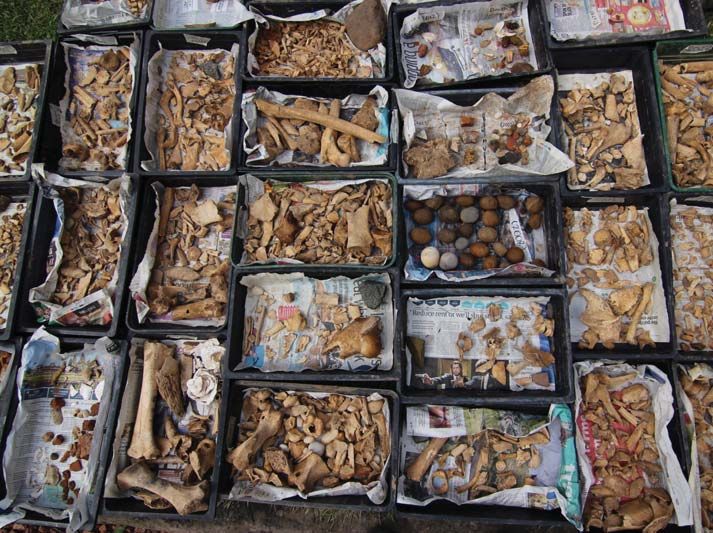
Lindisfarne: The Holy Island Archaeology Project

Assessment Report and Updated Project Design

                     Compiled by:
                     Chris Casswell

                 With contributions by:
       David Petts, Rosalind McKenna, Andrew Sage

                      DigVentures
                     The Workshop

                      Victoria Yard

                       26 Newgate

                     Barnard Castle

                     County Durham

                       DL12 8NG

                  hello@digventures.com

                     0333 011 3990

                                                    ii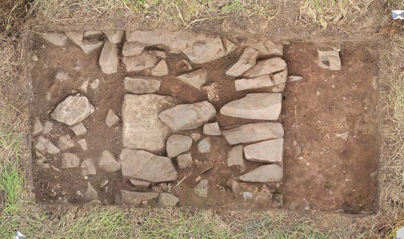
Purpose of document
This document has been prepared as an Assessment Report (Part 1) and Updated Project
Design (Part 2). The purpose of the first part of this document is to provide an account of the
archaeological excavations undertaken in 2017, including the results of fieldwork, specialist
reporting and links to the full archaeological record. It is supported by an easily accessible
online database of all written, drawn, photographic and digital data.is to provide an outline of
planned fieldwork, aims and objectives of the work, and methodology to be employed. The
second part of the document builds on the results and recommendations of the first, providing
an outline for planned 2018 fieldwork, including aims and objectives of the work, and
methodology to be employed.
DigVentures accepts no responsibility or liability for any use that is made of this document
other than by the Client for the purposes for which it was originally commissioned and
prepared.

Copyright
© DigVentures Limited 2018

Project summary
 DV project code and type       LDF18

 National Grid Reference        NU 12650 41758

 County                         Northumberland

 Title:                         Lindisfarne: The Holy Island Archaeology Project

 Author(s):                     Chris Casswell

 Origination date:              18th July 2018

 Circulation:                   Stakeholders and DV specialist team

 Reviewed by:                   Manda Forster PhD MCIfA

 Approval:                      Brendon Wilkins MCIfA

                                                                                               iii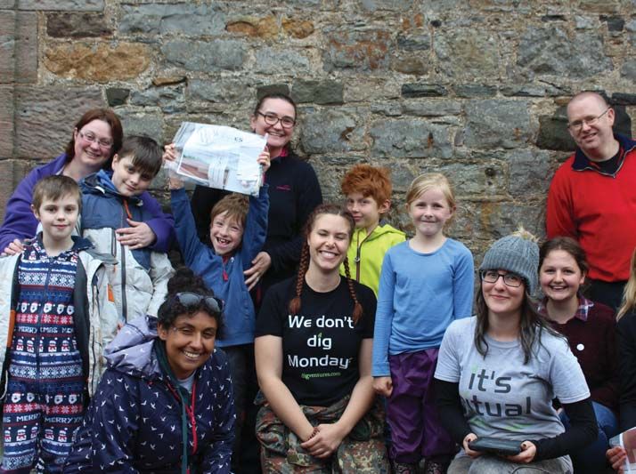
Social Value Act
DigVentures is a social enterprise dedicated to designing and delivering publicly focussed
archaeology projects. We are constituted as a limited company, with a constitution reflecting
the wider social, economic and environmental benefits of the projects we deliver.

Carbon Footprint
A printed copy of the main text in this document will result in a carbon footprint of 99g if 100%
post-consumer recycled paper is used and 126g if primary-source paper is used. These figures
assume the report is printed in black and white on A4 paper and in duplex.

DigVentures is aiming to reduce its per capita carbon emissions.

Acknowledgements
Thanks, are due to our project partners at Durham University, in particular to David Petts who
has not only helped us throughout, but was instrumental in our involvement in the project.
Thanks are also extended to the landowners, Crossman Estate, and to the Diocese of
Newcastle for giving us permission to excavate. Mr J Patterson provided kind support and
practical help, by facilitating access to the trenches and a place to store our tools.
Further contributions, helpful advice and direction throughout this project could not have been
achieved without the following groups. Archaeological and Architectural Society of Durham
and Northumberland for contributions towards 3D mapping. The Institute of Medieval and
Early Modern Studies, Durham University for support in bringing the project together in its
early stages. David Sugget at HLF Peregrini, Mary Gate House for providing a dig HQ and
Lindisfarne Pilgrims Coffee House for supporting the caffeine needs of the team. A big thank
you is also due to the people of Lindisfarne for welcoming the team to the island and for taking
such an active interest in the project.
The project was managed for DigVentures by Brendon Wilkins, with Lisa Westcott Wilkins in
the role of Project Executive, supported by Dr David Petts from Durham University. Chris
Casswell managed the fieldwork. Archaeological Service Durham University completed the
initial geophysics survey, with aerial photography and photogrammetry managed by Adam
Stamford from Aerial-Cam.
The project was funded exclusively by voluntary contributions from the public, so final thanks
must go to our community of Venturers, without whom this work would never have taken place:
Adam Doskey, Alison Burnal, Alison Dixon, Alison Fisk, Andrew Digwood, Anita Cain, Ann
Jansson, Anna Roik, Anne Campbell, Annette Shores, Barbara Wood, Bill Balding, Brenden
McIntyre, Brian Stokes, Brigitte Vosse, Caitlin Corning, Callum Tulpin, Carole Ann Warburton,
Carole Romanowski, Carole Souter, Caroline Evans, Caroline Heffer, Catherine Berger,
Catherine Petts , Catriona McFarlane, Charlie Bell, Chris Lowe, Chris Swindells, Christina Smith,
Christine Hancock, Christine Medlock, Christine Newman, Christy Garrett, Claire Capelin,
Conchita Pina, Corina Vogt, Dana Bently, David Brackenbury, David Hazel, David Osborne,
David Thorpe, David Young, Dayna Thomas, Debbie Barney, Debbie Simpson, Deborah
Curtis, Diane van Duzen, Dianne Peake, Dominic Arblaster, Donald McFarlane, Doug Hopper,
Edmund Stammers, Edwin Lambert, Edythe Scott, Eira Ihalainen, Elaine Dale, Eleanor Wallace,

                                                                                                iv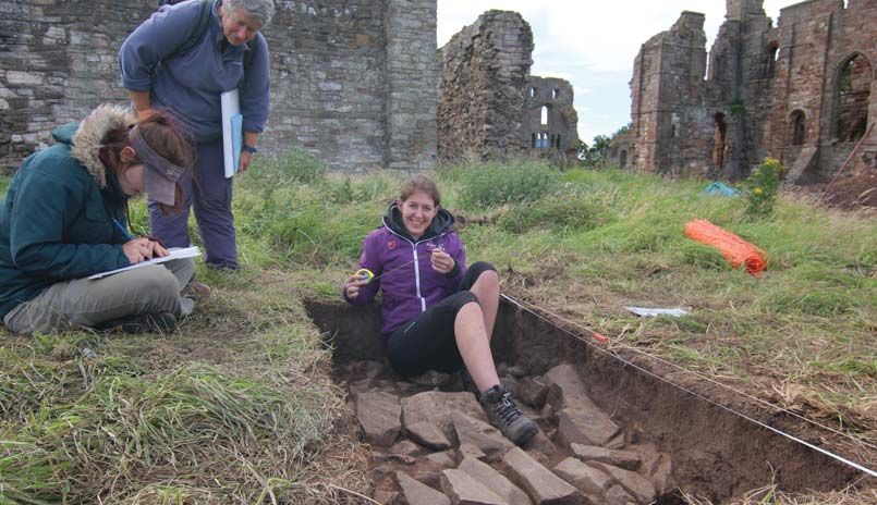
Elizabeth Tutty, Emma Easter, Ewa Kedzierska, Father O'Toole, Federico Piacentini , Frances
Stenlake, Frances Versluys, Freya Carter, Gareth Marklew, Gemma Alexander, Gillian Fawcett,
Gillian Young, Gregory Jennings, Hannah O'Toole, Hazel White, Heather Allen, Heather
Beaman, Heather Para, Helen Beckett, Helen Purcell, Iain Sutherland, Ian Malcolm, Ian
Spittlehouse, Jacqueline Howard, Jacqueline Shaw, Jane Garland, Janet Coe, Janet Ross,
Janine Millward, Janine Millward, Jean Romanowski, Jennifer Jackson, Jeremy Arnold, Jessica
Rutter, Jessica Rutter's, Jo Irvine, Joan Sutherland, Joanna Harrison, Joanna Henderson, John
P. Sexton, John Pratt, Joseph Marshall, Judith Keen, Julia Simpson, Julian Ingleby, Julie
Kolehmainen, Karen Burchard, Karen Smith, Kate Bunting, Katrina Attwood, Katrina Atwood,
Katrina Gardner, Keith J Wells, Kendra Johnson, Kevin Wilbraham, Knut Wefling, Kristin Hart,
Kym Gregg, Laura Rich, Linda Jacquest, Linda Nathan, Lisa Hicks, Lisa Roberts, Liz Shea, Lori
Stoppel, Lorraine Crawley, Louis van Dompselaar, Louise Harrison, Lyn Howe, Margaret
Owens, Margaret Schmeisser, Martin Braddock, Martin Holt, Mary Purvis, Mary Stofflet, Mary
Swale, Matthew Alexander, Matthew Harffy, Michael Eden, Michael Janas, Mick Bridgman,
Molly Johnson, Neil Coalwood, Neil Harper , Niamh O'Toole, Nicole Volmering, Nigel Dixon,
Olivier Kedzierska, Parris P McBride-Martin, Patricia Gregg, Paul Hudson, Paul Smith, Peter
Fisk, Peter Herbert, Peter Lee, Peter Palmer, Peter Walker, Richard Arnopp, Richard Frith, Rita
Baker, Roger Dacier, Roger Ferrand, Roger Thomas, Rosie Harrison, Rosie O'Toole , Ruby
Hardy, Russell Ó Ríagáin, Ruth Feather, Sally Thomas, Sandra Garside-Neville, Sara Hardy,
Sarah Brooks, Sarah Hooper, Scott Graham, Shannon Godlove, Sharon Callinan, Sharon
Murray, Shawna Lemoine, Simon Lloyd, Simon Scott, Sonia Carnell, Stephanie Foster,
Stephanie Stanley, Stephen Brown, Stephen Martin , Steven Purvis, Sue Nagle, Susan Lesser,
Tim Hill, Tonicha Upham, Tracey Guiry, Trevor Fitzjohn, Valerie Fargo, Valerie Rowe, Vivienne
Dunstan and Yvonne Doughty,

                                                                                              v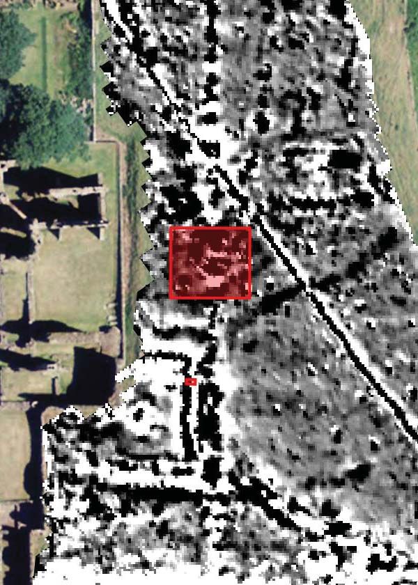
Executive summary
This document is submitted in support of continued fieldwork on the Lindisfarne research
project on Holy Island, carried out by DigVentures in partnership with Durham University. It
provides an interim report on the 2017 fieldwork results and outlines plans for 2018. The
project fieldwork will take place between 3rd and 26th September 2018 and will comprise a
community-based archaeological investigation at Sanctuary Close, immediately east of the
Priory church.
A MORPHE/PRINCE2 compliant document has been produced outlining key archaeological
research questions, roles, procedures, stages and outputs. The overarching aim of this
fieldwork is to provide baseline information to contribute to the future management, research
and presentation of the site, creating multiple educational and participatory learning
experiences for community participants. This will be achieved through a community-based
archaeological research project designed to:
define the results of previous non-invasive surveys, refining the chronology and
phasing of the site with a programme of trenching; and
understand the site’s archaeological and palaeoenvironmental conditions.
This document is presented in two parts; Part 1: Assessment report provides a post-excavation
assessment of the results of the 2017 fieldwork season, including a background to the project,
aims and objectives, a summary of the results and recommendations for further work. Part 2:
Updated project design builds on from the results of the 2017 fieldwork to outline a proposal
for work to be undertaken in 2018. This includes a proposed methodology, key sources and
activities required to support the delivery of the proposal’s outcomes, identifying
responsibilities of individual project staff members and outlines the tasks and programme. The
Updated Project Design provides an outline of methodology and planned intervention to
complete:
Targeted excavation Excavation of two archaeological evaluation trenches within Sanctuary Close,
immediately east of the Priory church. The full extent of Trench 2 will be
reopened with an extension in the northwest corner targeting a suspected
building foundation, and Trench 4 will be extended significantly to explore
the Infirmary building wall and internal features.
Public engagement The project is supported by a comprehensive learning, engagement and
activity plan. An innovative digital recording system will be used to enable
volunteers to record and publish on smartphones or tablets in the field;
specifically developed learning materials will be used to deliver schools
sessions, with a dedicated project website, underpinned by a digital and
audience building strategy.
vi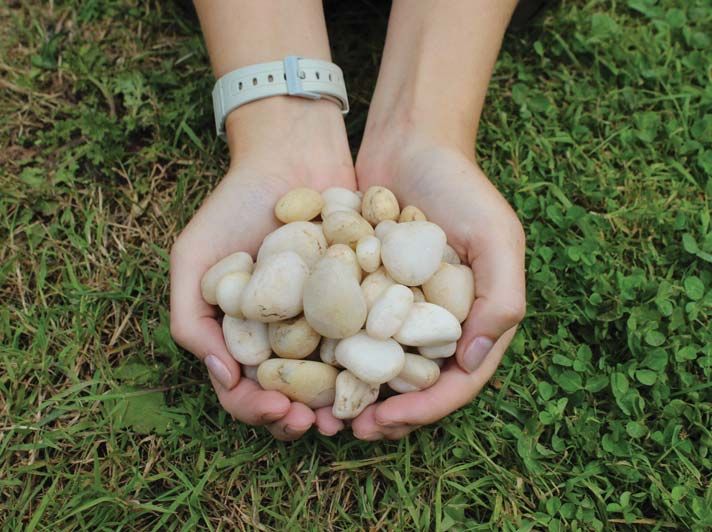
Contents
PART 1: ASSESSMENT REPORT                                                                                                                  1
1 INTRODUCTION                                                                                                                      1
1.1 Project summary ............................................................................................................... 1
2 BACKGROUND                                                                                                                          1
2.1 Research context .............................................................................................................. 1
2.2 Summary of previous work ............................................................................................... 2
2.3 2016 fieldwork .................................................................................................................. 3
3 PROJECT AIMS AND OBJECTIVES                                                                                                               4
3.1 Background ...................................................................................................................... 4
3.2 Aims .................................................................................................................................. 4
4 METHODOLOGY                                                                                                                         5
4.1 Project model ................................................................................................................... 5
4.2 Excavation methodology .................................................................................................. 5
4.3 Health and safety .............................................................................................................. 6
5 EXCAVATION RESULTS                                                                                                                    6
5.1 Introduction ...................................................................................................................... 6
5.2 Stratigraphic sequence ..................................................................................................... 7
5.3 Trench 2 (Figure 3) ............................................................................................................ 7
5.4 Trench 4 (Figure 4) ............................................................................................................ 8
6 ARTEFACTS AND ECOFACTS                                                                                                                 9
6.1 Small finds......................................................................................................................... 9
6.2 Pottery; medieval ............................................................................................................ 10
6.3 Pottery; post-medieval and early modern ...................................................................... 10
6.4 Pottery; chronology ........................................................................................................ 11
6.5 Environmental; results .................................................................................................... 11
6.6 Environmental; conclusions ............................................................................................ 12
7 DISCUSSION                                                                                                                          13
7.1 Introduction .................................................................................................................... 13
7.2 Monastic buildings ......................................................................................................... 13
7.3 Cemetery ........................................................................................................................ 14
7.4 Infirmary cloister ............................................................................................................. 14
7.5 Recommendations (Aim 4) ............................................................................................. 14
PART 2: UPDATED PROJECT DESIGN                                                                                                           15
8 UPDATED PROJECT AIMS AND OBJECTIVES                                                                                                 15
8.1 Introduction .................................................................................................................... 15
8.2 Updated project aims and objectives ............................................................................ 15
9 BUSINESS CASE                                                                                                                16
9.1 SHAPE sub-programme.................................................................................................. 16
9.2 Research frameworks ...................................................................................................... 17
10 INTERFACES                                                                                                                            20
11 COMMUNICATIONS                                                                                                                   21
11.1 Project team ................................................................................................................. 21

                                                                                                                                          vii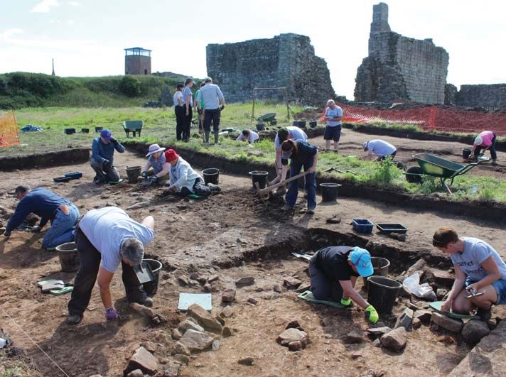
11.2     Project management .................................................................................................... 21
11.3     Outreach and engagement .......................................................................................... 22
11.4     Dissemination and reporting ........................................................................................ 23
11.5     Project archive .............................................................................................................. 23
12 PROJECT REVIEW                                                                                                                     23
13 HEALTH AND SAFETY                                                                                                                  24
14 PROJECT TEAM STRUCTURE                                                                                                    24
14.1 Team and responsibilities ............................................................................................. 24
16 METHODOLOGY                                                                                                                       26
16.1 Introduction .................................................................................................................. 26
16.2 Stage 6 – Updated Project Design ............................................................................... 26
16.3 Stage 7 – Archaeological Fieldwork ............................................................................. 26
16.4 Stage 3 – Assessment Report & Updated Project Design ........................................... 26
16.5 Stage 4 – Analysis and Publication ............................................................................... 27
17 STAGES, PRODUCTS AND TASKS                                                                                              27
17.1 Methodological Linkages ............................................................................................. 27
18 OWNERSHIP                                                                                                                          28
19 RISK LOG                                                                                                                           29
20 BIBLIOGRAPHY                                                                                                                       30

                                                                                                                                       viii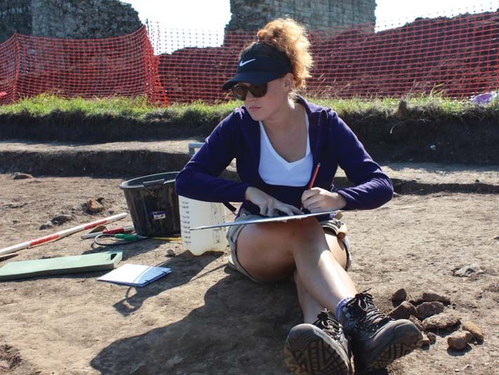
Tables
Table 1: Key NERF research priorities ..................................................................................... 19
Table 2: Project interfaces ....................................................................................................... 21
Table 3: Project review stages ................................................................................................. 24
Table 4: Team and responsibilities .......................................................................................... 25
Table 5: Methodological Linkages .......................................................................................... 28
Table 6: Risk log ...................................................................................................................... 29
Table 7: Trench 2 context descriptions ................................................................................... 49
Table 8: Trench 4 context descriptions ................................................................................... 50
Table 9: Small finds register .................................................................................................... 54
Table 10: Pottery types and count .......................................................................................... 56
Table 11: Pottery catalogue .................................................................................................... 58
Table 12: Sample catalogue .................................................................................................... 59
Table 13: Plant macrofossils .................................................................................................... 59
Table 14: Charcoal................................................................................................................... 59
Table 15: Sample components ................................................................................................ 60
Table 16: Finds catalogue (Trench 2 and 4) ............................................................................ 67
Table 17: Linking methods with objectives ............................................................................. 68

Figures
Figure 1: Site location .............................................................................................................. 32
Figure 2: Trench locations overlying geophysical survey ........................................................ 33
Figure 3: Trench 2 excavation results ...................................................................................... 34
Figure 4: Trench 4 excavation results ...................................................................................... 35
Figure 5: Meet the team .......................................................................................................... 36
Figure 6: Site work ................................................................................................................... 37
Figure 7: Finds ......................................................................................................................... 38
Figure 8: 2018 trench locations ............................................................................................... 39
Figure 9: Proposed area of GPR survey .................................................................................. 40

Appendices
Appendix A: Trench and context descriptions ........................................................................ 41
Appendix B: Small finds register ............................................................................................. 51
Appendix C: Pottery catalogue ............................................................................................... 55
Appendix D: Environmental catalogue ................................................................................... 59
Appendix E: Finds catalogues ................................................................................................. 61
Appendix F: Method statements ............................................................................................. 68
Appendix G: Core Staff CVs .................................................................................................... 75

                                                                                                                                          ix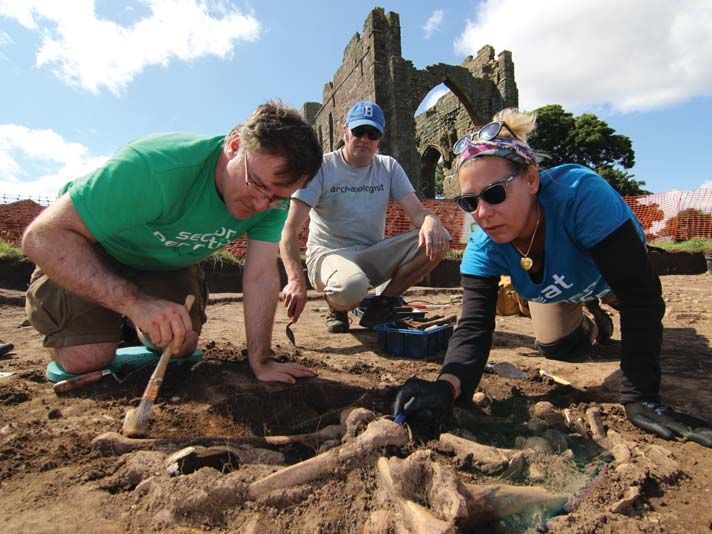
Part 1: Assessment report
1 INTRODUCTION
1.1 Project summary
1.1.1 This document provides an Assessment Report and Updated Project Design (UPD) for
a community-based archaeological investigation at Lindisfarne (hereafter ‘the site’,
Figure 1, NGR NU 12650 41758). The project is a multi-staged archaeological project
with an ongoing post excavation programme. This report provides an interim summary
of the results from the 2017 fieldwork season and defines how DigVentures intends to
deliver the 2018 phase of the project, outlining how research aims and participation
targets will be met. All DigVentures projects are managed according to a MoRPHE
project model (Management of Archaeological Research Projects in the Historic
Environment; Historic England 2012) – itself based on a PRINCE2 public sector project
delivery framework.
1.1.2 The overarching aim of fieldwork is to provide baseline information to contribute to
the future management, research and presentation of the site, creating multiple
educational and participatory learning experiences for community participants. This
will be achieved through a community-based archaeological research project
designed to:
Identify the physical extent and character of the archaeological remains on the site
with a programme of remote sensing.
Characterise the results of non-invasive survey, refining the chronology and
phasing of the site with a programme of trenching.
Understand the site’s archaeological and palaeoenvironmental conditions.
Make recommendations, analysis and publication.
2 BACKGROUND
2.1 Research context
2.1.1 Holy Island (Lindisfarne) is a small tidal island (technically a tombolo) lying just of the
northeast coast of Northumberland. It is best known, archaeologically, as the site of a
major Anglo-Saxon monastery founded in AD635 by Oswald, King of Northumbria
and Aidan, a monk from Iona. Whilst a significant quantity of early medieval sculpture
has been recovered from the area of the later medieval priory, there have been no
confirmed archaeological sightings of the early monastic site. This project aims to
locate elements of Anglo-Saxon Lindisfarne building on previous work on the island
by David Petts (Durham University).
2.1.2 In addition to Holy Island's important early religious heritage, the island has seen long-
term settlement from the Mesolithic to the 21st century. The current Holy Island village
and the adjacent priory ruins have been the focus of occupation since the Middle
Ages. Following the dissolution of the monasteries in the 16th century, there was
substantial investment in constructing defensive installations to protect against
1possible incursions from Scotland as well as raids from the Dutch. The fishing industry
grew increasingly important in the 18th century and in the 19th century the island
became an important centre for the quarrying of limestone and its subsequent
conversion into lime in the two large limeworks that were operated. These declined in
the early 20th century. Since then, whilst farming and fishing remain important to the
local economy, tourism has become increasingly central to life on the island.
2.2 Summary of previous work
2.2.1 Compared with other major early monastic sites, such as Iona, Whithorn,
Monkwearmouth and Jarrow, there has been relatively little direct archaeological work
in the probabe area of the monastic enclosure. The most significant programmes of
work in the immediate locality have taken the ruins of the medieval priory as their
focus. Extensive clearance of the rubble-choked complex of standing structures was
undertaken by William Crossman, the landowner in the 1890s, whose work was
centred on the cloistral range. His work was supplemented by further clearance by the
Ministry of Works (MoW) under the supervision of Charles Peers in the early 20th
century. Both sets of work have seen only limited publication (Crossman 1890b; Peers
1923-4) although most of the finds are held by Historic England in their stores in
Helmsley. Notes relating to Crossman's work are held in the Northumberland Archives
and the paperwork relating to MoW work is at Helmsley. Crossman also carried out
some limited exploration on the site of nearby St Cuthbert's Island, the location of a
probably Anglo-Saxon hermitage and certainly used as such in the medieval period.
2.2.2 There was no further archaeological work on the island until 1962, when the noted
field archaeologist, and excavator of the major Anglo-Saxon palace site at Yeavering,
Brian Hope-Taylor, turned his attention to Holy Island. Over the course of a month he
carried out a series of excavations in and around the village. He placed three trenches
in Rectory Field, due west of the parish church. This revealed evidence for later
medieval occupation, although there were hints of earlier features. It was not easy to
understand this early activity though due to the limited size of his intervention. He also
excavated three trenches on or against the Heugh. Two revealed further evidence for
medieval occupation, whilst one, exploring a rectangular feature on top of the Heugh
revealed a small building. The lack of any identifiable ceramics from this structure
suggests a possible early date, although this has not been confirmed by scientific
dating. Hope-Taylor's excavations were never published. Some of his plans, sections
and site notes were recovered after his death and are now in the RCAHM in Edinburgh.
The project team have digitised them, and their publication is part of the wider aims
of this project.
2.2.3 Following on from a small excavation on the site of the current English Heritage visitor
centre by Deirdre O'Sullivan in 1977, a major campaign of archaeological work was
initiated by O'Sullivan and Rob Young under the auspices of the Department of
Archaeology, University of Leicester. This ran from the mid-1980s to the mid-1990s. A
wide range of activities took place including geophysical survey (particularly of the
Heugh and the area to the east of the Priory), survey of Mesolithic sites on the north
side of the island, earthwork survey of the Kennedy limekilns and other sites,
excavations at the major midden of Jenny Bell's Well, fieldwalking, and, most
significantly as far as early medieval material is concerned, the site of Green Shiel, an
important rural settlement on the north side of the island, which comprised a series of
2long houses and produced a substantial faunal assemblage. A large number of interim
reports related to this material have been published, although no final report has yet
been produced (O'Sullivan 1985; O'Sullivan 1989; O'Sullivan and Young 1991, 1992,
1993, 1995, 1996).
2.2.4 Since the cessation of the Leicester campaign of research, archaeological research on
the island has largely been limited to Development Control excavation. The most
significant intervention of this kind took place on the site of the Lindisfarne Winery,
when its shop was extended. This revealed a sequence of post-medieval and medieval
activity, including a significant build-up of midden deposits. However, beneath this
were a number of earlier ditch and pit features, one of which contained an early
medieval comb (NAA 2001). Possible early medieval activity was also identified in
excavations carried out in advance of the construction of community housing on Castle
View Gardens, which revealed a substantial post-medieval/recent soil accumulation
overlying at least one, if not two, medieval structures fronting Green Lane as well as
remains of a possible early medieval sunken floored building – frustratingly the
archives, finds and environmental samples from this site appear to have been lost. A
number of smaller interventions have been made across the village, whilst several of
these have produced evidence for late medieval or early post-medieval midden
deposits and some structural features; none have produced clear indications of early
medieval activity.
2.2.5 In 2012, a major new geophysical magnetometry survey of the island was carried out
by Archaeological Services Durham University on behalf of David Petts (Durham
University) with the financial support of National Geographic. This resurveyed some
areas covered by the Leicester project, as well as taking in large areas to the north and
west of the village. This produced evidence for a second cloister at the Priory, probably
an infirmary cloister. It also produced a series of features of uncertain date to the east
of the Priory church. To the north of the village, little was found, beyond evidence for
medieval agriculture and a small ditched enclosure of unknown date. To the west of
the village, western extensions of both Marygate and Priors Lane were identified as
well as a network of small paddocks or enclosures and an area of potential industrial
activity of uncertain type or date (Petts 2013).
2.3 2016 fieldwork
2.3.1 Three evaluation trenches were excavated by DigVentures over the course of the 2016
field season, each located to investigate possible features identified from the
geophysical survey. In addition to this a programme of remote sensing was
undertaken, including a low-level aerial survey of the site. A full report on the results
of this work was made by Wilkins et al. in 2016.
2.3.2 Trenches 1 and 2 were located to explore the possible remains of the Anglo-Saxon
monastic complex to the east and southeast of the medieval priory church in Sanctuary
Close. Results suggested that the area may have originally formed part of an early
Christian burial ground which was later abandoned, disturbed and cleared to make
way for a later phase of construction. Disarticulated human remains, stone demolition
rubble and broken funerary objects, as well as sporadic quartz pebble fragments and
the extremely rare find of a broken ‘name-stone’ burial marker, were recovered within
deposits sealing in-situ burials. The burials had been disturbed and cleared to make
3way for later structures, although fragments of human bone were large in size and
seem not to have been displaced too far from their original burial placement.
Radiocarbon dates from three samples of human bone indicate that the cemetery was
in use between the late 8th to late 10th century AD. Structural remains were recorded
in both trenches and found to be medieval in date, indicated by the recovery of an
8th century Anglo Saxon coin during excavation of a floor surface.
2.3.3 Excavation in Trench 3 revealed extensive evidence for medieval occupation of 13th
century date and later, which appears to confirm that Prior’s Lane had not only existed
at this time, but continued into this area and that on the south side it had been flanked
by medieval domestic activity. An important aspect of the artefactual and faunal
assemblage recovered was the presence of a range of material relating to the maritime
economy of the village. The recovered assemblage contained significant quantities of
fishbone, iron fish-hooks and clench nails. Whilst Trench 3 did produce a potentially
earlier object (bone comb), the bulk of artefactual evidence suggests that the features
were 12th century or later.
3 PROJECT AIMS AND OBJECTIVES
3.1 Background
3.1.1 The aims and objectives articulated below were defined in the Project Design for this
stage of research (Wilkins and Petts 2016). The business case for this work has been
designed in accordance with the fundamental principles of Historic England’s
Strategic framework for the Historic Environment Activities and Programmes (SHAPE)
(ibid. 12).
3.2 Aims
3.2.1 The overarching aim of the project is to define and characterise the physical extent of
the site through a programme of non-intrusive investigations and intrusive excavation,
obtaining baseline data that will facilitate its future management. This project model
is framed as overarching aims and key questions/objectives that provide a framework
for the methods, stages, products and tasks set out in Part 2 below.
3.2.2 Aim 1 – Define and establish the precise physical extent and condition of the Site with
a programme of remote sensing and metric survey
Q1: Can the layout of the site and associated sub-surface archaeology be
established by remote survey?
Q2: Can we identify the location of the structural remains?
3.2.3 Aim 2 – Characterise the results of non-invasive survey, refining the chronology and
phasing of the site with a programme of trenching
Q3: What can we say about the scale and nature of any structural remains?
3.2.4 Aim 3 – Understand the site’s archaeological and palaeoenvironmental conditions
4 Q4: What is the current state of the archaeological and palaeoenvironmental
material across the site?
Q5: Can the palaeoenvironmental data recovered from sampling in the trenches
inform us about farming, food processing, industrial or medical activities?
Q6: Can we increase our understanding of the local environment in the medieval
period?
3.2.5 Aim 4 – Making recommendations, analysis and publication
Q7: How well do deposits survive, and how deeply are they buried?
Q8: Can we assess the state to which the archaeological and palaeoenvironmental
resource at Lindisfarne is being successfully preserved in situ, and how is this being
impacted by farming and bioturbation?
Q9: Formulate recommendations for further archaeological and
palaeoenvironmental analysis at Lindisfarne based on Aims 1-3, and implement a
programme to publish and disseminate the results.
4 METHODOLOGY
4.1 Project model
4.1.1 The archaeological fieldwork was carried out in accordance with the methodology
defined in the Project Design (Wilkins and Petts 2016). All work was undertaken in
conjunction with best practice, national guidelines and published standards, including
CIfA Standards and guidance (CIfA 2014). A summary of methodologies is presented
below, following detailed descriptions in the Project Design linking specific techniques
to aims and objectives.
4.2 Excavation methodology
4.2.1 Excavation took place between 10th and 29th July 2017 to address the research
questions associated with Aims 1 and 2. This entailed a programme of targeted
interventions comprising two trenches. Trench 2 from the 2016 field season was
extended to the west and north, forming a 17m x 15m trench designed to further
investigate the potential for the presence of an early Christian burial ground that had
been cleared to make way for a later phase of construction. A smaller trench (Trench
4) measured 2m x 1m and was positioned to investigate the eastern wall of the
suspected infirmary cloister.
4.2.2 All trenches were located using a GPS prior to the commencement of work, and each
area scanned for finds with a metal detector prior to, and during, excavation. All
trenches were de-turfed by hand and machine excavation was carried out in Trench 2
using a JCB 3CX fitted with a toothless ditching bucket, removing the overburden to
the top of the first recognisable archaeological horizon, under the constant supervision
of an experienced archaeologist. Trench 4 was excavated entirely by hand.
4.2.3 Trenches were subsequently hand-cleaned, planned and photographed prior to hand-
excavation. Any archaeological features and deposits exposed in the trenches were
hand-cleaned and excavated to determine their nature, character and date. Carefully
chosen cross-sections were then excavated through features to enable sufficient
5information about form, development, date and stratigraphic relationships to be
recorded. Excavated features were dry-sieved for artefacts using a 10mm gauge.
4.2.4 A complete drawn record of the trenches comprises plans and sections drawn to
appropriate scales and annotated with coordinates and AOD heights. A single context
recording system was used to record the deposits and a full list of all records is
presented in Appendix A. Layers and fills are recorded ‘(2001)’. The cut of the feature
is shown ‘[2001]’. Each number has been attributed to a specific trench with the
primary number(s) relating to specific trenches (i.e. Trench 2, 2001+, Trench 4, 4001+).
Features were also specified in a similar manner, pre-fixed with the letter ‘F’ (i.e. Trench
2, F201+, Trench 4, F401+).
4.2.5 All interventions were surveyed using a GPS tied into the Ordnance Survey grid. All
recording was undertaken using the DigVentures Digital Dig Team recording system.
Digital Dig Team is DigVentures’ bespoke, cloud-based, open data recording
platform, designed to enable researchers to publish data directly from the field using
any web-enabled device (such as a smartphone or tablet) into a live relational
database. Once recorded, the born-digital archive is instantly accessible via open-
access on a dedicated website, and published to social profiles of all project
participants (community, professional and specialist). Links to all individual trench,
feature and context records are provided in Appendix A, from where all associated
finds, samples, plans, sections, photographic records and 3D models can also be
explored.
4.3 Health and safety
4.3.1 All work was carried out in accordance with its company Health and Safety Policy, to
standards defined in The Health and Safety at Work etc. Act 1974, and The
Management of Health and Safety Regulations 1999, and in accordance with the
SCAUM (Standing Conference of Archaeological Unit Managers) health and safety
manual Health and Safety in Field Archaeology (1996), and DigVentures Health and
Safety Policy.
5 EXCAVATION RESULTS
Chris Casswell
All digital context and feature records have been archived on the Digital Dig Team
system and can be reviewed at https://digventures.com/lindisfarne/ddt/browser.php
and by clicking on the links in green in the text.
5.1 Introduction
5.1.1 During 2017, one excavation area and one smaller evaluation trench were investigated
in Sanctuary Close. The principle purpose of these excavations was to define and
establish the precise physical extent and condition of archaeological remains (Aim 1),
to characterise the results of non-invasive survey, refining the chronology and phasing
(Aim 2), and to understand the palaeoenvironmental conditions at the site (Aim 3).
Each trench was designed to address specific research objectives, and these are
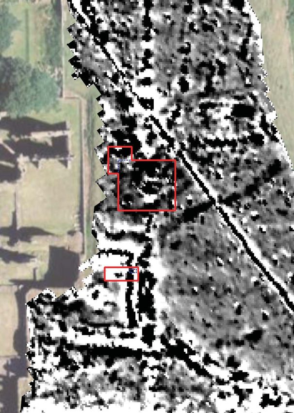
discussed with the excavation results below. Figure 2 shows the overall location of
6each targeted area, Figure 3 the illustrated excavation results from Trench 2, and those
for Trench 4 on Figure 4. Detailed descriptions of every context are included in
Appendix A, organised by trench number.
5.2 Stratigraphic sequence
5.2.1 A common stratigraphic sequence was recognised across the site. Trench 2, for
example, comprised topsoil (2001) overlying orange brown silty sand subsoil (2002).
The stratigraphic sequence fluctuated in depth across the site predominantly due to
natural height variation with the underlying topography.
5.3 Trench 2 (Figure 3)
5.3.1 Trench 2 measured 17m x 15m and involved re-opening the original trench from the
2017 fieldwork season and extending it to the north and west. The purpose of this was
to further investigate the human remains recovered to see if any in-situ burials
remained and whether they were associated with early medieval monastic buildings.
A 2m wide baulk was retained across the excavated area as a result of the presence
of an electric cable identified on the geophysical survey.
5.3.2 The earliest archaeological horizon encountered was a layer of compact clay (2015)
and (2056). All archaeological features were cut into this layer or were found overlying
it. Two fragments of wall F211 and (2042) were found on the eastern side of the baulk,
aligned roughly north to south, probably representing part of the same structure. The
stones used in the construction were large – each measuring up to 0.6m x 0.4m x 0.3m
– and showed signs they had been roughly hewn into shape. They also exhibited
plough damage on their upper surfaces, which may explain the fragmentary nature of
the wall in the centre of the trench.
5.3.3 Two adult inhumation graves F204 and F205 were cut into the early clay layer and
were situated centrally in the eastern part of the trench. They were both aligned east
to west and contained the fully articulated human skeletal remains of two individuals
in an extended supine position with heads at the western end with hands overlying
the pelvis. The position of the western grave F205 respected the end of one of the
wall fragments (2042), suggesting that the burials had been made after the wall had
been constructed. Seven quartz pebbles were recovered from the fill of this grave,
four from around the skull and two either side of the pelvis, suggesting they may have
been placed as grave markers. In addition to this two fossils known as ‘St Cuthbert’s
Beads’ were also found, possibly incorporated into a rosary that was buried along with
the individual.
5.3.4 To the north and east of the graves were five linear arrangements stones (2046),
(2047), (2048), (2049) and (2054). They were oriented roughly east to west and may be
the remnants of stone-lined graves; however, because of the mixed nature of the
underlying and overlying layers, no grave cuts were identified. It is anticipated that
should excavation continue in this area, further human remains could be encountered.
5.3.5 In the northwest corner of the trench an L-shaped feature was identified in plan and
interpreted as a possible wall-line for a structure F213 that extended beyond the edge
of the excavation to the north and west. It consisted of an intermittent line of five
7worked stone blocks separated by a deposit noticeably void of stone inclusions.
Without excavation the form of the wall could not be determined, but is likely to have
been a mixed wood and stone construction. Within its footprint were three other
features: a small posthole F209, a short length of ditch F210 and a later, shallow pit
F206 cutting it. The posthole measured 0.1m in diameter and was 0.05m deep,
positioned just within the projected line of the southern section of the wall. The ditch
was found to the north of this extending to the southeast from the northwest corner
of the excavation. It was 2.15m long, 0.1m wide and 0.1m deep, and had shallow
sloping, irregular sides and base. At its southeastern end it was cut by a circular pit
filled with fragments of plaster adhering to small angular stone rubble. It is possible
that the plaster found within this feature originally derived from the wall of the building
it was positioned next to.
5.3.6 In the southern part of the trench was a ditch aligned east to west F208. It was found
following the removal of an overlying layer (2039) in a 2m wide sondage placed against
the west-facing baulk section. The ditch had concave sloping sides down to a rounded
base and measured 0.5m wide and 0.16m deep. The remains of a truncated cobbled
surface (2052) comprising worn cobbles lay immediately to the south of the ditch,
suggesting an association.
5.3.7 Overlying the clay layer (2015) was a large spread of stony material comprising
frequent large sub-angular cobbles within a sandy silt soil matrix (2008) and (2021). It
was found both sides of the baulk in the northern part of the trench and to the south
surrounding the largest section of wall F211 to the south. Four iron nails (SF45, 47, 50,
51) and an iron hook (SF48) were recovered during excavation. It is likely this layer is
associated with the tumble of the wall because it was confined to within 3m of its
projected north-south line; its absence in the centre of the trench likely down to its
truncation by a later furrow running across the trench.
5.3.8 In the western part of the trench this layer was overlain by a clayey, stony subsoil (2019)
and (2039) that contained a small assemblage of pottery dating to the later-13th to
mid-14th century and two pieces of painted or stained medieval window glass (SF38,
39). In turn, this layer was cut by a large furrow (2020), measuring 6m wide and 0.1m
deep that crossed the trench from east to west and produced a range of pottery types
indicating a later-14th to 15th century date for its formation. A 1.4m long, 0.8m wide
charnel pit F203 was found cut into the furrow and contained the disarticulated human
skeletal remains of a number of individuals.
5.4 Trench 4 (Figure 4)
5.4.1 Trench 4 measured 2m x 1m and targeted a recti-linear, low resistance anomaly
identified from previous geophysical survey results and interpreted as a second
cloister at the Priory, probably an infirmary cloister. The purpose of this trench was to
characterise the buried archaeology and provide baseline data for future investigation.
5.4.2 One large, 0.9m wide wall F401 was found running north to south through the centre
of the trench. It comprised roughly hewn, locally sourced stone blocks – each
measuring approximately 0.35m x 0.18m – with no indication of mortar bonding them
together. Layers were reduced both sides of the wall to establish whether there was
any facing evident; however, none was found.
85.4.3 On the west side of the wall was a reddish brown silty clay layer (4004) that contained
frequent stone rubble inclusions. To the east of the wall was an orange brown silty clay
(4003) with significantly less stone inclusions. Both layers were excavated to a depth
of 0.1m below the top of the wall, but not to the base of either.
5.4.4 All remains were sealed beneath the subsoil (4002), the base of which coincided with
the top of the wall. This layer was the only one in the trench to produce datable finds:
two sherds of 13th to 14th century Scarborough ware and two sherds of a 17th century
albarello jar.
6 ARTEFACTS AND ECOFACTS
Chris Casswell, David Petts (small finds), Andrew Sage (pottery), and Rosalind
McKenna (environmental)
All digital finds records have been archived on the Digital Dig Team system and can
be reviewed at https://digventures.com/lindisfarne/ddt/browser.php and by clicking
on the links in green in the text.
6.1 Small finds
6.1.1 The finds assemblage from the 2017 season was relatively small consisting of only 34
objects, many of which were from secondary contexts, such as topsoil and cleaning
layers. Very few have any diagnostic value for dating any of the site.
6.1.2 The assemblage was dominated by iron objects, including ten iron nails, probably
hand-made (SF27, 36, 42, 44, 45, 47, 52, 53, 55). There were also a series of
unidentifiable iron objects (SF29, 30, 40, 43, 46, 50), some of which may also be parts
of fragmented nails. Given the proximity of the cemetery it is possible that these
objects may be related to coffins, although none were found in situ within a grave cut,
and there were none of the larger iron straps and clench bolts commonly associated
with 8th/9th century chest burials. One more identifiable item was an iron hook (SF48).
This was more robust than the small iron fishing hooks recovered in medieval contexts
in the 2016 season (eg. SF1, 14, 16), and is unlikely to have been related to fishing.
Finally, there is a small iron stud or button (SF49) of unidentifiable form. All iron objects
will be X-rayed over the coming year.
6.1.3 The small copper alloy assemblage comprised a Victorian or modern St Christopher’s
Medallion from the topsoil, most likely a relatively recent loss by a tourist or other
visitor. There is one undiagnostic cu alloy lump (SF26) and a badly eroded coin (SF28).
It was not possible to identify the date or any other features of the coin, but following
further conservation it will be revisited.
6.1.4 The glass consisted mainly of fragments of thin window glass (SF31, 32, 33, 38, 39,
41), including some which appeared to be fragments of painted or stained glass (SF31,
38, 39). These are most likely to derive from the medieval priory and may have reached
the area of the trench following post-Dissolution stripping of the Priory in the mid-16th
century. The stained glass held by English Heritage derived from the late 19th and
early 20th century excavations within the Priory will provide useful comparisons.
96.1.5 There was one badly fragmented piece of bone which appeared to have a series of
scored or incised lines running around the outside; the item appears to be worked,
but it is not easy to identify a possibly date or function for the object.
6.1.6 Two fragments of possible carved stone were found (SF35, 56). These show some
evidence of working, but given their fragmentary nature further examination is
required to confirm that this was deliberate rather than due to accidental damage such
as plough strike. They will be shown to the team from the Corpus of Anglo-Saxon
Stone Sculpture for further comment.
6.1.7 Two small fossils of the type known locally as St Cuthbert’s Beads were found (SF58,
59), this join the similar item and another fossil (SF2, 4) found in 2016. These items are
commonly found on the island’s beaches, although they may have been deliberately
brought to the area of the excavation. One small possible worked flint was identified
(SF57).
6.2 Pottery; medieval
6.2.1 The medieval pottery assemblage comprised 43 sherds, weighing 356g, with a high
level of fragmentation common throughout the assemblage. Like other medieval
assemblages from Lindisfarne the pottery appears to be sourced from a relatively wide
variety of regional sources. In this instance these can be divided into three main
groups; the lower Tweed Valley, micaceous sandy wares from south Northumberland,
and Tyneside and Yorkshire sources. The date range of the medieval pottery spans
the later 12th to 15th centuries and no particular peak of activity could be identified.
6.2.2 The typical Tweed Valley Wares are uncommon in the assemblage however a small
number of fine sandy wares (2001), (2002), (2019) and (2020) appears to represent a
fine sandy variant of Tweed Valley Ware. Later Lower Tweed Valley types are
represented by sherds of Berwick type Late Reduced Greenware (2020). A single sherd
of Lucker Hall-type ware was present in the assemblage (2001). Lucker Hall, to the
south of Belford, is the nearest known pottery production site to Lindisfarne, and our
current understanding of the chronology of this ware is limited; the type is broadly
dated to the 12th to early 14th century.
6.2.3 The second component of the medieval assemblage is dominated by low-fired
micaceous sandy wares (2002) and (2020) similar to those produced during the 12th
to early 14th century at sites such as Eshott. Sources on Tyneside and in Yorkshire are
represented by small quantities of Scarborough Ware (2002) and (4002), Tyneside
Buff-White Ware (2002) and Newcastle Late Reduced Greenware type 4 (2002).
6.3 Pottery; post-medieval and early modern
6.3.1 The post-medieval and early modern pottery assemblage consisted of 57 sherds,
weighing 533g was also heavily fragmented with some elements notably abraded. The
post-medieval assemblage is from a range of British and European sources. Regionally
produced material included Berwick-type English Redware (2002) and (2020) and later
glazed red earthenwares from Tyne- or Wearside (2001) and (2002). Types from
southern England were represented by metropolitan-type slipwares (2002), London
tin-glazed wares (2001), (2002) and (4002) and Surrey-Hampshire border ware(2002).
10European types are represented by Rhenish stonewares (2001) and (2002), Werra
slipwares (2001) and (2002) and Martincamp-type 1 ware (2002).
6.4 Pottery; chronology
6.4.1 The majority of the pottery in the assemblage was from topsoil and subsoil, both of
which contained a very broad span of medieval to early modern types. Two sherds of
pottery came from context (2019); a sherd of a finer sandy variant of sandy Tweed
valley ware, and a sherd of hard-fired Tyneside ware, indicating a later-13th to mid-
14th century date for this layer.
6.4.2 The furrow (2020) contained a range of 13th to 15th century types. Whilst English
redware is generally dated to the 17th century this sherd is not typical in that it is
largely undecorated with the exception of some splashes of brown glaze and may
represent an earlier late-medieval phase of production. The lack of other post-
medieval types in this context compared with the topsoil and subsoil would also
indicate a later-14th to 15th century date.
6.4.3 The single sherd of 19th century transfer printed ware found in the fill of the grave
grave F205 must be considered intrusive in this context. The subsoil in Trench 4 (4002)
contained only two small sherds of 13th to early 14th century Scarborough ware and
two sherds of a 17th century albarello jar.
6.5 Environmental; results
6.5.1 In total, ten samples were recovered from the 2017 season and seven samples were
processed for assessment (Table 11). Charred plant macrofossils were present within
two of the samples SAM25 and SAM27. Indeterminate cereal grains were recorded in
both of these samples, and these were identified based on their overall size and
morphological characteristics, which may suggest a high degree of surface abrasion
on the grains. This is indicative of mechanical disturbances that are common in
features such as pits and ditches, where rubbish and waste are frequently discarded.
Given that these remains were recovered from the soil relating to skeletal remains, it
may indicate that the poor preservation is due more to a high burning temperature
which has caused the grains to warp and explode, before then being deposited. Whilst
only four grains were recorded from the fill of the charnel pit SAM25 (2017), there
were numerous fragments of probable grain, but due to such poor preservation they
have not been recorded as definite grains. The results of this analysis can be seen in
Table 12 below.
6.5.2 The samples produced very small suites of plant macrofossils, both in terms of quantity
and diversity. Due to this fact, other than to state their presence in the samples,
nothing of further interpretable value can be gained. The presence of root / rootlet
fragments within most of the samples indicates disturbance of the archaeological
features, and it may be due to the nature of some features being relatively close to
the surface, as well as deep root action from vegetation that covered the site. The
presence of earthworm egg capsules, together with the remains of insect fragments
within some of the samples, and snails in a single sample further confirms this.
116.5.3 Charcoal fragments were present within the majority of the samples, scoring between
a ‘1’ and ‘3’ on the semi quantitative scale. The preservation of the charcoal fragments
was fair to poor. The majority of the fragments were too small to enable successful
fracturing that reveals identifying morphological characteristics. Where fragments
were large enough, the fragments were very brittle, and the material crumbled or
broke in uneven patterns making the identifying characteristics difficult to distinguish
and interpret, and so only a limited amount of environmental data can be gained from
the samples. Identifiable remains were however present in two of the samples, and
the results of this analysis can be seen in Table 13 below.
6.5.4 The total range of taxa comprises oak (Quercus). This taxa belongs to the groups of
species represented in the native British flora. As seen in Table 13, oak was the only
recorded species within the samples. It is possible that this was the preferred fuel
wood obtained from a local environment containing a broader choice of species. The
compositions of the samples are very similar, it is probable therefore that the
assemblages of charcoal remains, reflect the deposition or build up of domestic waste.
6.5.5 Generally, there are various, largely unquantifiable, factors that affect the
representation of species in charcoal samples including bias in contemporary
collection, inclusive of social and economic factors, and various factors of taphonomy
and conservation (Thiery-Parisot 2002). On account of these considerations, the
identified taxa are not considered to be proportionately representative of the
availability of wood resources in the environment in a definitive sense, and are possibly
reflective of particular choice of fire making fuel from these resources.
6.6 Environmental; conclusions
6.6.1 The samples produced some environmental material of interpretable value, with the
charred plant macrofossils from two of the samples, and the charcoal remains from
two of the samples. The deposits from which the samples derive, probably represent
the deposition or buildup of domestic waste associated with fires. The charred remains
recovered are small in numbers and tend to be of average to poor quality - charred
material that was within the samples appears to have been subjected to high
temperatures of combustion, as the grains were severely puffed and distorted. It also
tended to be abraded and fragmented, possibly as a result of post depositional
disturbance and taphanomic processes.
6.6.2 The remains of plant macrofossils recovered from the samples showed the utilisation
of indeterminate cereal grains. There is no evidence of cereal processing occurring at
the site, or of any plant remains that may indicate some industrial use. The samples
have produced broadly similar results suggests that these deposits do not result from
deposition of debris from accidental charring events, but instead represent a
consistent pattern of charring cereal grain, chaff and crop weeds which are then
incorporated into the waste of the site over the period of occupation.
6.6.3 The charcoal remains showed the exploitation of a single species native to Britain. Oak
has good burning properties and would have made a fire suitable for most purposes
(Edlin 1949). Oak is a particularly useful fire fuel as well as being a commonly used
structural/artefactual wood that may have had subsequent use as a fire fuel (Rossen
and Olsen 1985). Dryland wood species indicates the presence of an oak-ash
12You can also read