Investigation of a Survivors Camp from the Sydney Cove Shipwreck - By Mike Nash - Maritime Archaeology Monograph and Reports Series
←
→
Page content transcription
If your browser does not render page correctly, please read the page content below
Maritime Archaeology Monograph and Reports Series

                       No.2

       Investigation of a Survivors Camp
        from the Sydney Cove Shipwreck

                      By
                   Mike Nash

             Department of Archaeology
                Flinders University
                  South Australia
                       2004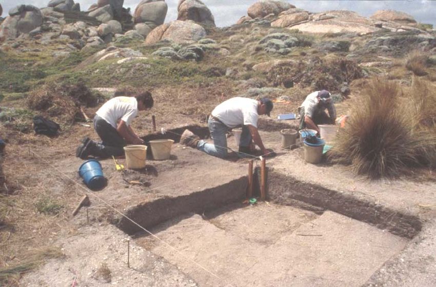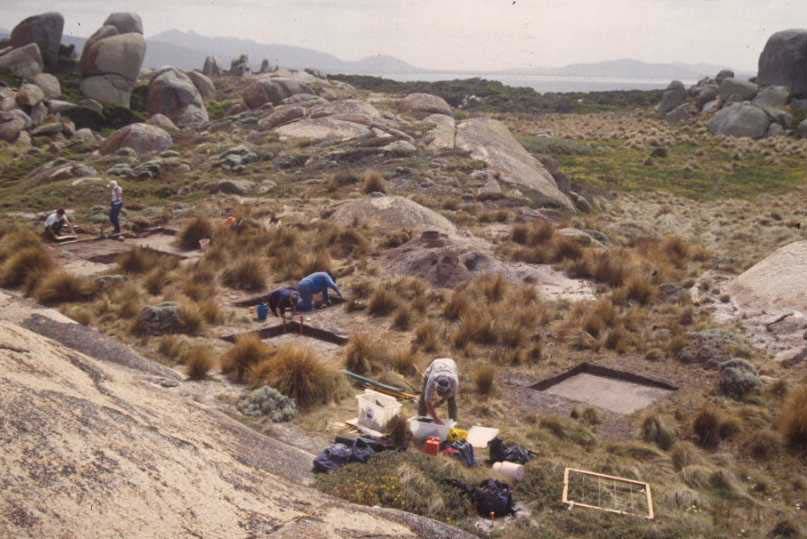
ISSN 1832-326X

First published in 2004
by the Department of Archaeology
c/o Flinders University
GPO Box 2100
Adelaide, South Australia, 5001

Copyright © the author 2004

All rights reserved. This monograph series is copyright apart from any fair dealings
for the purposes of private study, research, criticism or review, as permitted under the
Copyright Act, no part may be reproduced without written permission.
Enquiries should be addressed to the publisher.

Front cover illustration: Aara Welz at Preservation Island 2002 (Photograph by Mike
Nash)
Printed and bound by Flinders Press

Fifty copies of this document were printed at a cost of $4.69 per copy.
Published Monographs and Reports in the Maritime
       Archaeology Monographs and Reports Series

1.   Julie Ford      The Archaeology of Aircraft Losses in Water in Victoria,
                     Australia During World War Two (Master of Maritime
                     Archaeology Thesis, 2004)

2.   Mike Nash       Investigation of a Survivors Camp from the Sydney Cove
                     Shipwreck (Master of Maritime Archaeology Thesis, 2004)

3.   Adam Paterson   Understanding the Sleaford Bay Tryworks: An Interpretive
                     Approach to the Industrial Archaeology of Shore Based
                     Whaling (Bachelor of Archaeology Honours Thesis, 2004)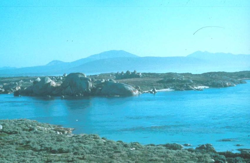
Maritime Archaeology Monograph and Reports Series

Maritime archaeology has been taught at undergraduate level in the Department of
Archaeology at Flinders University since 1996 and the first Bachelor of Arts Honours
thesis in maritime archaeology was completed in 1997. The introduction of the
Bachelor of Archaeology in 1997 saw undergraduate students specializing in maritime
archaeology for the first time and the first Bachelor of Archaeology Honours thesis
appeared in 1999. Then in 2002, a new Graduate Program in Maritime Archaeology
was introduced resulting in the first Master of Maritime Archaeology thesis in 2003.

Since 1997 a significant number of research theses and reports have been completed
by staff and students in underwater and maritime archaeology. The Honours and
Master of Maritime Archaeology theses are required to be approximately 15,000 to
18,000 words and therefore are rarely, if ever, published in full. As a result much of
this valuable research remains essentially unpublished and difficult to access - a part
of the "grey literature". The Department of Archaeology regularly gets requests for
copies and this research is becoming widely cited in journals such as the Bulletin of
Australasian Institute for Maritime Archaeology.

This series aims to publish in full some of the honours and postgraduate theses as well
as research reports written by staff and students in the field of maritime archaeology.
Hopefully this will help to disseminate the results of research to the professional
community in a simple, accessible and timely fashion. It is also hoped that this may
encourage students to publish shorter-length journal articles derived from their
research.

                                                Associate Professor Mark Staniforth
                                        Convenor of Studies in Maritime Archaeology
                                                         Department of Archaeology

Copies can be purchased by individuals at a cost of $10 per issue by contacting:

Department of Archaeology
Flinders University
GPO Box 2100
Adelaide, SA 5001
AUSTRALIA
email Mark.Staniforth@flinders.edu.au
08 8201 5195 (office) 8201-3845 (fax)

For information about the Department of Archaeology at Flinders University:
http://ehlt.flinders.edu.au/archaeology/

About Graduate Programs in Maritime Archaeology:
http://ehlt.flinders.edu.au/archaeology/courses/maritimegrad.php

                                                                                     1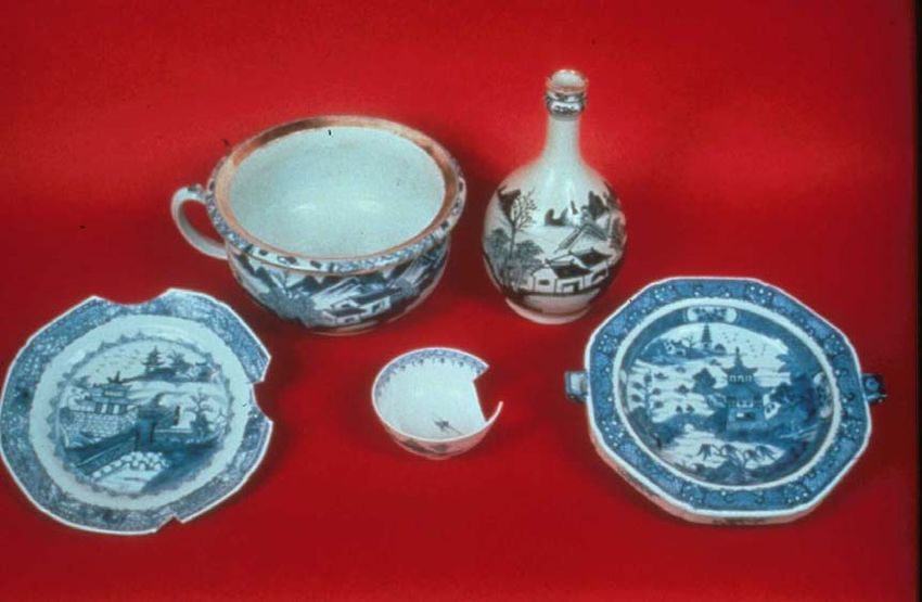
CONTENTS                                                  Page

        List of Figures                                    3

        Introduction                                       4

ONE     Literature Review - Shipwreck Survivor Camps       7

TWO     Methods - The Sydney Cove Case Study               16

THREE   Results - Material Culture of the Survivor Camp    31

FOUR    Discussion - Application of the Model              42

FIVE    Conclusions – Formation of Survivor Camps          55

        Bibliography                                       64

                                                                 2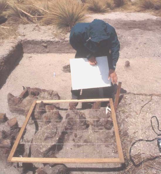
LIST OF FIGURES Page
Figure 1 – Location of the Sydney Cove historic site 19
Figure 2 – Preservation Island historic features 20
Figure 3 – Chart of Preservation Island showing shipwreck and campsite 21
Figure 4 – Excavation and recording of the Sydney Cove hull structure 24
Figure 5 – Overall view of the survivor camp excavation 27
Figure 6 – Close up view of the excavation in progress 27
Figure 7 – Plan of the survivor camp test excavations 28
Figure 8 – Intact Chinese export porcelain from the Sydney Cove 32
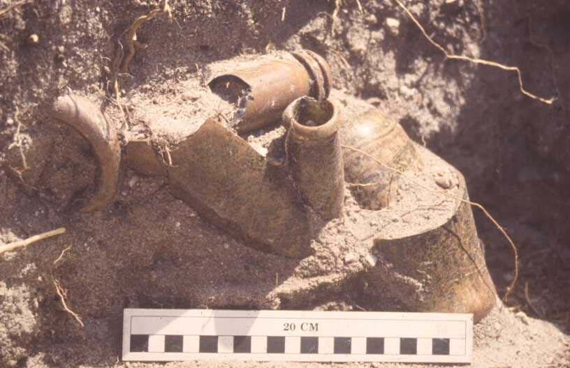
Figure 9 – Broken alcohol bottles lying in situ 36
Figure 10 – Intact alcohol bottles recovered from the Sydney Cove 37
Figure 11 – The short tailed shearwater or ‘mutton bird’ 38
Figure 12 – View of the southern end of Preservation Island 44
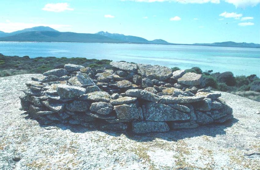
Figure 13 – Stone structure on Preservation Island 50
3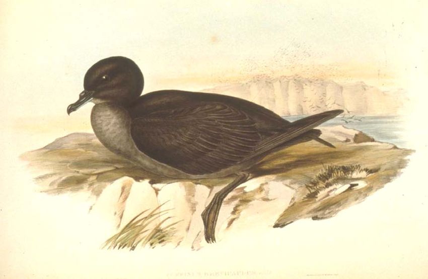
INTRODUCTION

       One of the great themes in the history of sea transportation is the survival of
the victims of shipwrecks. Disaster at sea and the sufferings of the survivors has
exerted a continuing fascination because of the catastrophic nature of the occurrence.
In the great age of sail and steam the volume of seaborne traffic and the extent of
settlement meant that shipwreck survivors had a reasonable chance of rescue, but
those who were isolated by geography or communications could be forced to fend for
themselves for long periods of time. If these groups reached land they would have to
cope with the problems of subsistence, isolation, difficult group dynamics, and a
possibly hostile terrain. Commonly they carried out actions such as salvaging cargo
and equipment, establishing a social or command structure, adapting to the local
environment, and developing rescue strategies. The setting up of a camp or base of
operations is also a central theme in shipwreck survivor accounts.

       An account of the loss of the barque Rebecca on the west coast of Tasmanian
in 1853 gives some idea of the problems facing shipwreck survivors when they
reached shore. ‘The following day, after the bodies which were washed ashore were
interred, we searched the beach for provisions, but could only obtain a bucket-full and
a half of bread (which was carefully picked up from among the wreck, and washed in
fresh water), and several small tins of herrings. We then rolled some empty water
casks up the embankment, stove one head in each, and turned them over for an
encampment … we only had one herring a-day per man, with a cup full of biscuit, but
plenty of bottled ale and porter, and were without the means of obtaining fire. I then
determined to that two parties should start, one to the south and the other north’
(Broxam, 1993:12-13).

       Given that there is a large body of information on shipwreck survivors there
has been remarkably little consideration of the subject as a field of documentary or
archaeological study. In part this may be explained by the concentration of maritime
archaeological research on the more technical aspects of ship construction and their
cargoes, rather than what may be regarded as ‘peripheral’ historical events. The
subject of survivor camps also poses many questions regarding human behaviour, a
subject area that maritime archaeology has not generally explored in great detail.

                                                                                     4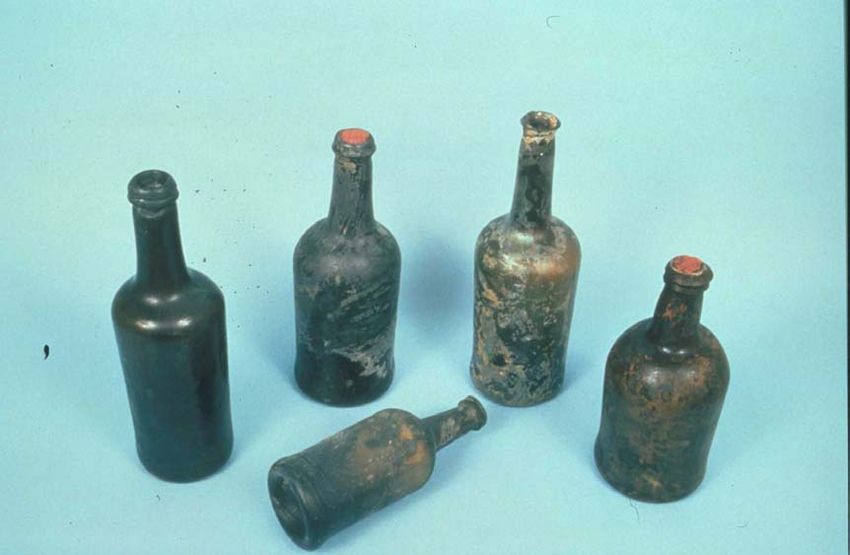
Another explanation is proposed by Gibbs (2003:128): ‘Because of the historical
peculiarities of individual situations, existing studies have treated survivor camps as
separate and unique, rather than as a class of site to be subjected to comparative
study’. In the same paper Gibbs puts forward a comparative framework for the study
of shipwreck survivor camps as a class of archaeological site. This model highlights a
number of elements or themes that are common to the development of shipwreck
survivor camps and how these might be reflected in the archaeological record. In 2002
an opportunity to investigate the subject of shipwreck survivor camps came about
with the location and test excavation of a land site associated with the loss of the ship
Sydney Cove at Preservation Island, Tasmania.

       Wrecked in 1797 during a journey from Calcutta to Port Jackson, the Sydney
Cove is the eighth oldest shipwreck in Australian waters, and the first merchant vessel
lost after the establishment of the colony of New South Wales. Since the rediscovery
of the shipwreck in 1977 an extended program of survey, excavation and analysis has
been carried out under the direction of the Tasmanian Parks and Wildlife Service.
While this work was concentrated on the underwater site it was known that the
survivors of the wreck had occupied nearby Preservation Island for almost 12 months,
and had left documentary and archaeological evidence of their activities. Surveys of
these features and the collection of surface material were carried out on a number of
occasions (Strachan, 1986a:86-92) but the location of the survivor’s camp was never
positively identified. During 2002 the author, in association with staff and students
from Flinders University, carried out test excavations at a site that has been confirmed
as a dwelling constructed by the Sydney Cove’s crew. A collection of artefact material
was subsequently recovered including items of the ship’s cargo, fittings and
equipment, personal articles and foodstuffs.

       This thesis will utilise the archaeological collections from both the underwater
and terrestrial sites associated with the Sydney Cove, to examine the subject of
shipwreck survivor camps in detail. The archaeological evidence will be
supplemented by the extensive documentary research that has been carried out on the
site over the last 25 years. The evidence from the Sydney Cove project will be
examined to see if the comparative model proposed by Gibbs (2003) can usefully be
applied to a single site, and whether modifications to the model are necessary. Chapter

                                                                                       5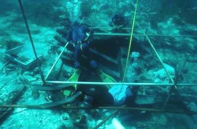
One will provide an overview of shipwreck survivor camp studies and a more detailed
exposition of a theoretical model proposed by Gibbs. Chapter Two will look at the
Sydney Cove project including the historical background, the excavation of the
shipwreck and the resulting research studies. The methods used in the survey and test-
excavation of the associated terrestrial sites will also be examined. Chapter Three will
describe the material culture of the campsite excavation and its broader context,
particularly as part of the overall history and archaeology of the shipwreck. Chapter
Four will look at the detailed application of the Sydney Cove study into the proposed
model for shipwreck survivor camps. Chapter Five will conclude with observations on
site formation processes, the material culture of shipwreck survivor camps, and a
summary of the suitability of the archaeological model for survivor camp formation.

                                                                                      6
ONE
LITERATURE REVIEW - SHIPWRECK SURVIVOR CAMPS
Over the last decade the practice of archaeology in Australia has begun to
increasingly blur the boundaries that once defined work in the ‘underwater’ or
‘terrestrial’ spheres. Although this has occurred to a limited degree in the research
area of prehistory (see Dortch, 1991, 1997, 2002) it is most readily apparent in the
discipline of historical archaeology - covering the period of European exploration and
settlement of the continent. Terrestrial and underwater sites from this period have
more similarities than differences including a common temporal setting,
corresponding cultures and artefacts, and the use of documentary evidence as a
research tool. They are only really separated by some of the technical aspects of
working underwater, the research emphasis on ship technology, and the relatively
short time periods of site deposition (the ‘time capsule’ analogy).
The coalescence of historical and maritime archaeology has become apparent
in a number of ways. Since 1995 practitioners of both sub-disciplines have
periodically attended joint conferences, and there is also an increasing trend to publish
in journals outside the specific sub-discipline, making research available to a wider
audience of professionals. Projects such as the Archaeology of Whaling in Southern
Australia and New Zealand (Lawrence and Staniforth, 1998) have redefined the
nature of cooperative research between the disciplines, as evidenced in the appearance
of some significant archaeological studies on the subject of shore-based whaling
(Gibbs, 1996; Lawrence, 1998, 2001; Nash, 2003).
Although largely concentrated on underwater shipwreck sites (as part of
legislative responsibilities), the study of maritime archaeology in Australia has also
been concerned with some of the broader research aspects of its subject matter. The
earliest work on the Dutch East India Company shipwrecks in Western Australia
included the investigation of associated shipwreck survivor camps (Bevacqua, 1974a,
1974b), and across Australia a range of studies over three decades have considered
such diverse maritime subjects as jetties (McCarthy, 2002, Rodrigues, 2002), dry
docks (Jeffery, 1995), port facilities (Nutley, 2003), fish traps (Welz, 2002) and
7pearling industries (Stanbury, 1994). This ‘holistic’ approach to maritime archaeology
has been considered in greater detail by McCarthy (2003), and its implications for the
study of terrestrial archaeological sites have been discussed by Stanbury (1983),
Effenburger (1987) and Nayton (1992).
As part of this increasingly wide application there has also been a noted
increase in the development of thematic studies of maritime sites, rather than the
historical particularist approach that focuses on a single site or event. This has
included the study of types of shipwreck sites such as steamships (McCarthy 1998a,
Veth & McCarthy, 1999), abandoned watercraft (Richards, 2002), and shipwreck
cargoes (Staniforth, 2003). The consideration of shipwreck survivor camps and their
characteristics as defined by Gibbs (2003) clearly falls within this type of thematic
study, and is of particular interest for its ‘overlap’ between underwater and terrestrial
sites.
The study of shipwreck survivor camps is an area of research that crosses a
number of definitional boundaries. As substantially terrestrial sites, survivor camps do
not strictly fall under the topics of ‘shipwreck’, ‘nautical’ or ‘underwater’ archaeology
but may have elements that relate to all these areas of study (Delgado, 1997:259-260).
The broader study of ‘the material remains of man and his activities on the sea’
(Muckelroy, 1978:3) is usually defined as ‘maritime archaeology’, and the topic of
shipwreck survivor camps may more easily fall into this category. Delgado
(1997:259) presented a more comprehensive definition of maritime archaeology as
‘the archaeological study of manifestations of maritime culture, including vessels,
shore-side facilities, cargoes and even human remains’, and this is particularly useful
for categorising the investigation of shipwreck survivor camps.
The excavation of a shipwreck site and its associated survivor camp as part of
an extended archaeological project is almost unique in both an Australian and
international context. While there were thousands of shipwrecks in Australian waters
relatively few of these disasters actually resulted in the establishment of survivor
camps. In the case of the Australian state of Tasmania there is very good historical
information on the wrecks that have occurred in local waters since the loss of the
Sydney Cove in 1797 (Broxam and Nash, 1998, 2000). Of the 1,100 plus shipwrecks
8in Tasmanian waters only 15 incidents actually resulted in the survivors staying in one
location for more than a week and possibly establishing a campsite. All these wrecks
occurred in geographically isolated areas such as the West Coast, the Bass Strait
Islands, or sub-Antarctic Macquarie Island, and most date from the ‘colonial’ period
(pre 1850) when settlement and shipping traffic was not as widespread.
Besides the Sydney Cove campsite, only two other terrestrial sites have been
relocated in Tasmania. Survivor camps associated with the wrecks of the Brahmin at
King Island (1854) and the George Marshall at Flinders Island (1862) are located in
sand dunes backing the coast and directly adjacent to the respective wreck sites (Nash,
1988:23-24, 1989). Hut sites constructed from ship timbers have also been found at
Macquarie Island but these activities may be associated with the sealing industry,
rather than shipwreck survivors (Townrow, 1989:29-33,46-48). Both the sites at King
Island and Flinders Island have been extensively ‘mined’ by local residents, largely
destroying any archaeological context. The possible sites at Macquarie Island have
also been subject to intensive historical use by sealing gangs, and extreme
environmental conditions.
Nationally, the Australian Historic Shipwrecks Database lists over 7,400
wrecks in Australian waters and the extrapolation of the Tasmanian statistics means
that at least 100, and possibly many more shipwreck survivor camps should exist.
However, work on this type of site has so far been limited and largely confined to the
early Dutch wrecks in Western Australia. The 1629 wreck of the Batavia at the
Abrolhos Islands has received the most attention with extensive archaeological
material, including human remains, associated with survivor massacres (Orme and
Randall, 1987; Gibbs, 1992, 1994, 2002; Pasveer 1998; Pasveer at al., 1998;
Stanbury, 1998, 2000). Material associated with the activities of Dutch shipwreck
survivors has also been recorded for the sites of the Zeewijk (Ingelman-Sundberg,
1976, 1977; Green, 1997) and the Zuytdorp (Morse, 1988; Weaver, 1994; Playford,
1996; McCarthy, 1998b).
From the colonial period (post 1788) very few survivor camps or associated
terrestrial features have been located or recorded. A substantial campsite associated
with the wreck of the French whaler Perseverant at Dirk Hartog Island, Western
9Australia, in 1841 has been surveyed (Robinson, 1988). Material from the six-week
occupation of Porpoise Cay, Queensland, during 1803 by survivors from the Porpoise
and Cato shipwrecks was located during survey work, but is very limited (Coleman
and Delaney, 1988). Evidence of a survivor’s camp associated with the 1835 wreck of
the convict ship Hive has also been located at Wreck Bay, New South Wales (Nutley,
1995).
On an international level the research that has been carried out on the subject
of survivor camps is very sparse. The campsite associated with the 1855 wreck of the
Julia Ann in the South Pacific has been investigated (Hundley, 1996, 2001). In South
Africa a land site from the 1630 Portuguese wreck Sao Goncalo (Smith, 1986) was
partially excavated, and a recent Masters thesis looks at Portuguese survivor camps
from the same period (1550-1650) (Burger, 2003). In the standard journals on
maritime or historical archaeology such as the International Journal of Nautical
Archaeology and Historical Archaeology, and their Australian equivalents, there is
virtually no mention of shipwreck survivor camps. Similarly, none of the standard
texts on maritime or underwater archaeology, such as Muckelroy (1978), Gould
(1983, 2000) or Delgado (1997) consider the subject.
Martin Gibbs has provided the only substantive overview of the subject of
shipwreck survivor camps in a recently published paper (2003), and this work will be
considered in detail when assessing the Sydney Cove site. In light of the paucity of
research on the subject Gibbs (2003:128) quite rightly considers that ‘shipwreck
survivor camps are a neglected terrestrial component of maritime archaeology, usually
being investigated purely as an adjunct to work on the associated wreck site’. The
paper goes on to provide a broader synthesis on the subject of shipwreck survivor
camps in Australia, and how these sites may be reflected in the documentary and
archaeological record. As a comparative framework Gibbs proposes a number of
common elements or themes that appear to occur in shipwreck survivor situations.
These include camp organisation and authority structures, location of campsites,
subsistence, shelters and structures, health and mortality, rescue strategies, indigenous
contact, and salvage operations. These themes will be considered in more detail
below.
10Authority, Social Structure, and Camp Organisation
Shipboard life on a sailing vessel was necessarily organised around a rigid
command structure, and this may be reflected in the actions or organisation of
shipwreck survivors on land. The transference of control in the terrestrial setting
mostly occurred without incident, particularly when Naval vessels were involved (see
Austin, 1964:188; Hamilton, 1793:108-111). Alternatively, the loss of officers or the
circumstances of the wreck could result in the breakdown of command and control as
evidenced in the events following the Batavia shipwreck, including the massacre of
survivors (Dash, 2002; Gibbs, 2002). In the archaeological record the maintenance of
a command structure may be reflected in the segregation of the living areas for
officers, crew or passengers. The examination of Portuguese shipwreck survivor
camps in South Africa by Burger (2003:91) certainly suggests that this was the case,
with the physical separation of officers, crew, soldiers, passengers and slaves.
Equally, the catastrophic nature of a shipwreck event may force the divisions between
social groups to blur or become realigned by necessity, as eventually occurred with
the communal housing of the Sydney Cove survivors. The presence of a command
structure and organisation may also be reflected in the archaeological record as more
focussed and effective salvage, subsistence and rescue strategies are carried out.
Relationship Between Wreck and Camp Location
Gibbs (2003:132) has proposed that people abandoning a ship will not
inevitably select the nearest point of land as a refuge. Factors such as the prevailing
currents, environmental conditions, geographical features, and the availability of boats
may all have bearing on a landing point and the subsequent establishment of a
campsite. The confused psychological condition of many of the survivors immediately
after a disaster, in what is termed the recoil stage, (Leach, 1994:25-28) may also effect
the decision making process. It is also possible that the initial landing point for a
shipwrecked crew will not become the long-term campsite as increasing familiarity
with the landscape and the requirements for survival and rescue may force a shift in
location. In a number of Australasian incidents the closest point of land was merely
the staging point for a shift to a more suitable location or journeys by boat or foot to
the nearest point of rescue. In 1848, for example, Preservation Island was a point of
refuge for survivors from the brig Governor Phillip, who had progressively shifted
themselves over 30 kilometres from the wreck site at Gull Island (Nash, 1996:38-41).
11Salvage
Common to many shipwreck survivor experiences was the opportunity to
salvage or remove material from a wrecked vessel. This activity has major
implications for the material culture of shipwreck survivor camps and was an integral
factor in many of the activities discussed in this Chapter. The extent of salvage
activities was predicated on factors such as the location and accessibility of the
shipwreck, the abilities of the survivors, their motivation for salvage (ranging from
subsistence to financial gain), and the access to tools and equipment such as boats.
Gibbs (2003:138-141) has considered the question of salvage activities in some detail
and divides them into five stages – jettisoning, crisis salvage, survivor salvage,
opportunistic salvage, and organised salvage. Salvage is one of a number of processes
that are crucial for explaining site formation processes on shipwreck sites (and
survivor camps) and the topic will be considered in greater depth in Chapter Five.
The archaeological signature of survivor salvage and usage could also be
complicated if rescue vessels were eventually involved. While survivors could take
with them a very limited quantity of material if they embarked on a rescue voyage or
trek, salvage vessels could remove a much greater variety of items including cargo,
stores, equipment, and personal possessions. In the case of the Sydney Cove there
were three voyages made to Preservation Island by the schooner Francis resulting in
the removal of a great deal of the salvaged cargo and equipment. Salvage of
shipwrecks and survivor camps by contemporary unrelated groups must also be
considered, as the loss of a vessel could present an economic bonanza to local
communities that had access to the location. Even the current day activities of
souvenir hunters at shipwrecks or survivor camps can be seen as part of this
continuum of behaviour.
Subsistence
In most cases the initial subsistence and material culture of survivors was
derived from the ship through removal at the time of striking, direct salvage, or the
collection of flotsam and jetsam. This was particularly evident if the wreck itself was
accessible and relatively intact. At a later stage a subsistence strategy could be
broadened to include foraging and exploitation of the local environment. This
12depended on the availability of natural resources such as water or edible wildlife, as
well as the opportunities and skills available to the survivors. Archaeological evidence
of such activities may be in the form of wells or water catchment systems, food
preparation and storage areas, livestock holding areas, and dietary evidence in the
form of faunal bones. Dietary evidence is a particularly significant consideration as it
can potentially show the nature and success of any adaptive strategies. Consideration
must also be given to ‘dietary conservatism’, whether from cultural or religious
grounds, and the effects that this may have on food choices if they were available
(Karskens, 1999:72-73).
Shelters and Structures
Along with subsistence the most important element for survival, particularly in
colder climates, was the construction of some form of shelter. Historical accounts and
images of shipwrecks mostly depict these shelters as ‘tents’ constructed from the large
quantities of canvas, rope and timber carried by sailing vessels. However, in some
cases more substantial dwellings or structures were constructed with the addition of
local materials and these may include accommodation huts, lookouts, signal fires,
cairns and even defensive works (Orme & Randall, 1987; Hundley, 1996). These
activities were related to the availability of materials, the length of stay, and the
reaction to difficult environmental conditions, such as those encountered by the
Sydney Cove survivors. The archaeological visibility of shelters and structures will
vary considerable and in many cases will be undetectable beyond a general location.
Potentially such structures may provide evidence of the survivor’s salvaging and
foraging activities, skills and organisation (Gibbs, 2003:134).
Health and Mortality
By their very nature, shipwrecks and their aftermath can have disastrous
effects on the health and mortality of those on board. In the short term the health of
shipwreck survivors could be effected by their prior condition, possible injuries
sustained in the wreck, and their psychological reaction to stress. Dietary deficiencies,
particularly scurvy, were always a factor in extended sea voyages and their
consequences could extend after shipwreck survivors reached shore. The
psychological effects of disaster on victim’s health are also well known, and there are
many instances of individuals simply ‘giving up’ and dying in circumstances where
13other members of the group survived (Leach, 1994:126-142). In Survival Psychology
Leach (1994:59-121) considered some of the other factors that may directly effect the
health of disaster survivors including fatigue, sleep disturbance, hypothermia, hunger
and thirst. A number of these factors are directly related to the local environment and
the adaptation of successful strategies for coping with the problems of subsistence and
shelter. In the case of deaths connected with survivor camps the most obvious
archaeological signature would be the burials of the victims. This would not only
come from the actual physical remains but also the form of burial, particularly as
noted on the ‘discarded’ victims of the Batavia massacres (Gibbs, 1992, 1994).
Development of a Rescue Strategy
Once survivors of a shipwreck had reached shore, established a camp and had
at least basic subsistence their next step might be to consider a rescue strategy. A
rescue strategy was predicated by a number of factors including access to resources,
opportunity, geographical location, and motivation through a command structure or
collective will. In some cases the survivor’s action could simply be to wait where they
were, if it was perceived that rescuers would be sent for them or the chances of being
seen by a passing vessel were good. The construction of signal cairns or lookouts to
facilitate rescue may be one archaeological signature of this behaviour. A second
possibility, if geography and knowledge were favourable, was to walk to safety. Some
of the Sydney Cove’s crew eventually travelled for hundreds of kilometres along the
coast of southeastern Australia (Nash, 2001:43-47) and there are numerous similar
instances from relatively isolated areas such as the Tasmanian west coast (Broxam
and Nash, 1998:95,97,153-155,188).
A similar strategy, if boats were available or a vessel could be constructed,
was to travel by sea to the nearest settlement. Some of the most epic sea voyages were
undertaken by shipwreck survivors over thousands of kilometres in small boats. In
Australasian waters the survivors of the Batavia (1629) and the Zeewijk (1727)
travelled over two thousand kilometres to Batavia and a similar voyage was
undertaken by the crew of HMS Pandora (1791) from the Great Barrier Reef to
Coupang (Delgado 1997:55,473; Gesner, 2000:16-17). Even during the colonial
period a rescue voyage from the 1841 wreck of the steamer Clonmel could take a boat
journey of over 250 kilometres along the Victorian coast (Harvey, 1999:16-18).
14Alternative and rarer long-term strategies could also include the establishment of a
new settlement such as the Bounty mutineers at Pitcairn Island (Erskine, 1999), or the
integration of survivors with indigenous communities (see below).
Survivors Camp as Contact Site
The Gibbs model (2003:136-137) considers the numerous incidents where
shipwreck survivors during the colonial period encountered indigenous people, often
as first contact between the races. The Sydney Cove’s crew in particular had one of the
most protracted and well recorded encounters with Aboriginal peoples during their
600 kilometre trek along the coast of New South Wales. Research in Western
Australia (Silvester, 1998), Victoria (Anderson, 2000) and South Australia (Jeffery,
2001) has highlighted how extensive these incidents were, even up to comparatively
recent times. Accounts of these encounters are usually of a positive nature with some
instances of survivors being assisted over a period of months. However, the perceived
or real threat of hostile ‘natives’ in an unknown land may also lead to defensive
behaviour in the group that may constrain their actions. The presence of shipwreck
survivors may also leave their own mark on indigenous populations – in stories, art,
and technology if material from a wreck or survivors camp is later utilised by the local
population (Morse, 1988; Nutley, 1995; Layton, 1997:7-22). There has also been
speculation on the passing of diseases and genetic disorders to Aboriginal populations
through close physical or sexual contact (Playford, 1996:210-232).
15TWO
METHODS - THE SYDNEY COVE CASE STUDY
Historical Background
In January 1788, the British government established a colony at Port Jackson,
New South Wales from the country’s crowded prisons. However, deficiencies in the
organisation of the First Fleet and the problems of applying European agricultural
techniques threatened the survival of the settlement for a number of years. The
difficulties of obtaining reliable stocks of food and equipment from Britain and the
Cape of Good Hope soon forced the British Government to consider India as an
alternative source of supplies for New South Wales. Despite earlier injunctions
against infringing the trading monopoly of the English East India Company, the
colonial governor was given permission to obtain supplies from India in 1790. The
store-ship, Atlantic was despatched to Calcutta in October 1791, returning with a
cargo of food and livestock in June 1792 (Historical Records of Australia, 1(1):768).
Private traders resident in India and operating under licence from the East
India Company rapidly followed the government initiative. Many of these merchants
formed loose associations known as agency houses, and the results of their activities
were collectively known as the country trade (Furber, 1970:264-297). The ascendancy
of the English East India Company in the latter half of the 18th century was reflected
in the increasing dominance of the country trade by vessels registered in India. During
this period, there was also a shift in emphasis in the direction of the trade from the
western Indian Ocean towards the eastern markets of China, the Malay Peninsula,
Indonesia, and as far as the north-west coast of America (Marshall, 1976:76-105).
In their constant search for profits, the country traders needed little
encouragement to speculate in new markets, and proposals to trade directly with New
South Wales were being received by 1790 (Historical Records of Australia, 1(1):222).
The first private merchant vessel to arrive at Port Jackson from India was the Shah
Hormuzier in February 1793, and another four ships followed before the end of 1795.
In the three decades after the appearance of the first country ship 129 vessels carrying
cargoes from India, totalling over 30,000 tons of shipping, arrived at New South
16Wales and Van Diemen’s Land (Tasmania). This represents close to 35% of the total
number of overseas shipping arrivals at Australian ports before 1820 and is exceeded
only by government vessels sailing directly from Britain (Nash 2001:70-72;
Broadbent et al., 2003:199).
The Sydney Cove’s voyage was organised by the merchant house of Campbell
and Clark, who had been established at Calcutta since 1790 (Steven, 1965:1-25).
Although few records of their business dealings exist, regular advertisements in the
Calcutta Gazette, indicate that the firm dealt mainly in alcohol, textiles, and China
goods. The circumstances of their decision to undertake a speculative voyage are
unknown but may have been prompted by their dealings with Captain James Storey of
the Sovereign, which had arrived from Port Jackson in May 1796. The vessel they
acquired for their enterprise was renamed Sydney Cove, in honour of its intended
destination, and research has possibly identified the ship as the country trader Begum
Shaw (Strachan, 1986a:97-98). In a 1794 sales notice the former Begum Shaw was
described as 5,000 bags of rice burthen, a remarkably fast sailor, new sheathed and
coppered up to the bends (Calcutta Gazette, 27 February 1794).
This description of the Begum Shaw is matched by archaeological evidence,
which demonstrates that the Sydney Cove was also copper-sheathed and exhibited the
features of a fast sailing vessel designed primarily for short coastal voyages.
Excavation evidence also suggests that the Begum Shaw/ Sydney Cove was originally
built in the Bay of Bengal region, possibly at Calcutta itself, as a two-decked, three-
masted ship with an overall hull length of around 100 feet (30 m) and a maximum
breadth of approximately 24 feet (7.5 m). Comparison of the estimated hull
dimensions of the Sydney Cove with other contemporary examples indicates a vessel
with a burden of 250-300 tons (Old Measurement).
The previous master and part owner of the Begum Shaw, Gavin Hamilton,
retained his command of the Sydney Cove and assembled a crew of eight Europeans
and 44 Indian seamen commonly known as lascars. Although a complete manifest of
the Sydney Cove’s cargo has not survived, there is some evidence of its composition
from the existing documentary and archaeological sources (Nash, 2001:28). The prior
involvement of Campbell and Clark in the spirit trade ensured that approximately
177,000 gallons (31,500 litres) of alcohol took up a large proportion of the cargo space.
The cargo also included rice and sugar, tobacco, salted meat, Chinese tea and
porcelain, tar, vinegar, soap, candles, leatherwear, Indian textiles, livestock and luxury
goods.
On 10 November 1796, the Sydney Cove departed from Calcutta and made
steady progress southwards until 13 December, when gale-force winds opened up a
leak on the starboard bow. Attempts to repair the damage were partially successful,
although water continued to enter the hull. On 25 January rough weather further
opened the bow timbers, forcing the crew to continuously man the pumps as well as
bailing directly from the pump well. During the two-day period before a fothered sail
could be deployed to reduce the leak, five of the Lascar seamen died at sea. In early
February, after rounding the southern tip of Tasmania, the ship again encountered
strong winds, culminating in a gale on 8 February that caused fresh ruptures to the
hull. Captain Hamilton turned the stricken ship westwards to pass through Banks
Strait, which separates Tasmania from the islands of the Furneaux Group.
On 9 February, the vessel was run aground in an estimated 19 feet (6 m) of
water between two small, low-lying islands (Fig.1). In this location, the vessel was
reasonably protected, allowing the crew and essential stores and equipment to be
landed on the southernmost point of what was subsequently named Preservation
Island (40°29’S, 148°04’E). Dominated by large granitic boulders, the island is
approximately 3 kilometres long (north to south) and 1 kilometre at its widest point,
and around 207.4 hectares in size. A camp was set up, and although the wreck was
almost completely submerged at high tide the crew salvaged over half the cargo.
When the men were found broaching the casks of spirits, that part of the cargo was
transferred to the smaller Rum Island (Hamilton, 1797:68-69). After the hull of the
ship had collapsed by early May 1797 the crew were put to work building a large
dwelling so they could survive the approaching winter.
On 27 February, the Sydney Cove’s longboat, with a crew of 17, had been
despatched northwards to seek assistance from Port Jackson. The small vessel was
subsequently wrecked on 2 March near Cape Everard, some 600 kilometres short of
18Fig.1 – Location of the Sydney Cove historic site (Tasmanian Parks and Wildlife
Service)
19Fig.2 – Preservation Island historic features (Tasmanian Parks and Wildlife Service)
its destination. The crew were forced to make an arduous overland trek, the details of
which were recorded by supercargo William Clark (Historical Records of New South
Wales, 3:760-768). After a two-month journey through unmapped rugged country,
during which they encountered numerous Aboriginal bands, all but three of the men
were left behind. On 15 May, the crew of a fishing boat sighted the survivors south of
Port Jackson. The men reached the colony the following day to report to Governor
John Hunter.
The 42-ton schooner, Francis, and the 10-ton sloop, Eliza, were despatched to
Preservation Island and arrived there on 10 June. All but six of the crew and a
quantity of cargo were embarked on the two vessels. The Francis reached Port
Jackson on 6 July, but the smaller Eliza was lost en route with six of the Sydney
Cove’s men on board. Reaching Port Jackson, Captain Hamilton lodged a ‘Ships
Protest’ detailing the circumstances of the voyage (Hamilton, 1797). The Francis
made two subsequent salvage voyages to the wreck and returned to Port Jackson in
March 1798 with the last of the undamaged cargo and the remainder of the Sydney
20Cove’s crew. The cargo, minus the spirits that the government had reluctantly agreed
to purchase, was put up for sale and fetched highly inflated prices (Collins, 1802:98).
Off the southern tip of Preservation Island, the destruction of the Sydney Cove
took a number of years. In February 1798 Lieutenant Matthew Flinders accompanied
the third salvage voyage of the Francis, and recorded that the wreck had broken up
during westerly gales and scattered its timbers and parts of the cargo throughout the
islands (Flinders, 1814:cxxviii). In October 1798 it was reported that some convicts
had stolen a boat near Sydney with the unsuccessful intention of sailing southwards to
the Sydney Cove wreck (Collins, 1802:78). In March 1802, a French scientific
expedition under Captain Nicholas Baudin noted some of the Sydney Cove’s
timberwork lying at nearby Clarke Island (Plomley, 1983:98). In 1804, it was reported
to colonial Governor King that the crew of an American sealing vessel were building
a craft from the timbers of the Sydney Cove (Historical Records of New South Wales,
5:384).
Fig.3 - Matthew Flinders 1798 chart of the Preservation Island showing location of
the shipwreck and campsites (Mitchell Library)
21The Shipwreck Excavation
In January 1977, divers relocated the wreck of the Sydney Cove with the
assistance of an original chart of the area produced by Lieutenant Matthew Flinders in
1798. The remains were found approximately 350 m from the southernmost point of
Preservation Island and less than 200 m from the eastern side of Rum Island. Water
depths over the wreck range from 4 to 6 m, according to tidal variations, and the
seabed consists of a fine sand and shell sediment largely covered by sea grass
(Posidonia australis). This growth protected the remains from further physical
damage and sealed the artefact deposits in a stable, oxygen-free environment that
aided their long-term preservation. The bottom topography is generally level, but
scour areas up to 1 m deep are found in the areas devoid of sea grass. The seabed
slopes slightly away to the south towards the deeper waters of Banks Strait.
Underwater visibility is usually over 10 m and currents are generally absent on the
site, except at the release of the ebb tide through the narrow channel between Rum
and Preservation islands.
Following the reporting of the site to the State government the significance of
the wreck and the need to legally protect the remains were quickly realised.
Previously, many other shipwreck sites in Australian waters had been located and
disturbed by divers before any formal study had taken place. In this case, future
archaeological work on a virtually untouched site was greatly enhanced by the
responsible attitude of the divers involved and their efforts to have the wreck fully
protected. On 29 March 1977, the wreck and the surrounding area, which included
parts of Rum and Preservation islands, was declared an historic site under the
Tasmanian National Parks and Wildlife Act 1970.
When the wreck of the Sydney Cove was rediscovered, the expertise to work
on underwater sites in Australia was still largely confined to Western Australia.
Consequently, the initial investigation of the site was undertaken by amateur groups,
which only gradually included professional staff backed by government funding. The
work on the wreck proved to be a major stimulus to the development of a maritime
archaeological program in Tasmania (Nash, 2003). One of the most important
outcomes of this increased interest was the acknowledgment of the heritage values of
shipwreck sites, which prompted the State government to become a signatory to the
22Commonwealth Historic Shipwrecks Act 1976 in 1982 (Dromgoole, 1999:1-16). In
1984 the Sydney Cove site was formally declared a protected site under the provisions
of this Act.
Initial survey work and test excavations carried out during 1977, 1978 and
1980 established that the surviving wreck structure and artefact clusters were
concentrated in an area measuring approximately 40 m by 10 m. An assemblage of
artefacts was raised during this work including the vessel’s rudder (Atherton and
Lester, 1982; Lester 1982). Test excavations also confirmed historical reports of the
wreck ‘lying much on one side’ (Hamilton, 1797:69). The 10° list to starboard had
resulted in a larger proportion (70%) of hull timbers surviving on that side of the
wreck. The tilt of the keel at 5° towards the stern had also preserved a greater quantity
of artefact material in the deeper sediment deposits at the southern end of the site.
Further work in the 1980s installed basic survey controls on the wreck and recorded a
number of features connected with the historical occupation of Preservation Island
(Clarke and Smith, 1986).
Building on a growing body of research on the Sydney Cove and other
comparative Australian sites, a seminar on Asiatic shipbuilding techniques was held
in Tasmania during 1985 (Green and Strachan, 1986). Summaries of the results of the
initial site work were subsequently produced (Strachan, 1986a; Clarke and Nash,
1988) and these reports set a number of further research goals. Between 1991 and
1994, a regular program of excavation on the site was directed by the author through
the Tasmanian Parks and Wildlife Service. The Queen Victoria Museum and Art
Gallery, Launceston, provided conservation assistance. Funding, personnel, and
equipment were obtained from Federal and State government organisations backed up
by the services of numerous volunteers.
By the end of 1993, five expeditions had uncovered a total of 216 sq/m of the
site, or approximately 55% of the area originally grided out on the seabed
(Nash,2001:87-94). While the excavated area included all remaining hull timbers and
the major concentrations of artefacts it was obvious from field observations and
historical documentation that material would continue to be found outside this area.
However, the expectation of diminishing returns and the need to consolidate the work
23that had already been undertaken precluded further excavation. A final expedition to
the wreck in March 1994 carried out stabilisation works on the remains, and periodic
monitoring of the site continues to be undertaken.
A major exhibition based on the artefacts and information gathered from the
site was officially opened at the Queen Victoria Museum in February 1997, on the
bicentennial of the loss of the Sydney Cove. The material subsequently travelled to
Tasmania and interstate venues for more than two years before returning to
Launceston. As conservation work on the various artefact groups was completed more
detailed studies were undertaken (Steele, 1995; Staniforth, 1996; Halley, 1997;
Staniforth & Nash, 1998), culminating in publications summarising the history and
archaeology of the site (Nash, 2001, 2002; Staniforth, 2003).
Fig.4 - Excavation and recording of the Sydney Cove hull structure (Tasmanian
Parks and Wildlife Service)
The Terrestrial Site
During the course of the underwater excavation work some recording of
artefacts and features associated with the on-shore activities of the Sydney Cove’s
crew had occurred. In 1974, three years prior to the discovery of the shipwreck, Mr
24David Carroll had collected a number of artefacts from the south-western end of
Preservation Island including bottle fragments, porcelain and earthenware identical to
types later excavated from the wreck (Strachan, 1986a:86-87). This material came
from the area that has been identified as the cargo landing and storage site. The high
point of ground behind this location was also identified as a possible historic site
because of evidence of artefact material, and was named ‘Lookout Rock’ in
subsequent reports.
During an expedition in April 1978 a close plot magnetometer survey was
carried out at Lookout Rock, covering an area of approximately 10 m by 10 m
(Henderson, 1978:27-32). The survey recorded a number of small anomalies,
probably from iron fastenings or barrel hoops, but these were not further investigated.
Fragments of ceramics and glass were also recorded from a seabird rookery lying
behind the cargo landing beach, where burrowing birds periodically uncovered a
range of artefact material. In 1978 and 1984 a number of historic structures on
Preservation Island were noted and recorded, and a 1985 expedition accurately
surveyed in these features (Clarke and Smith, 1986). They include stone cairns, stone
walls, a house foundation and artefact material associated with the historical
occupation of the island (Jetson, 1996). Further recording of these features, including
GPS position fixing, was carried out during 1999 in conjunction with geological and
vegetation surveys of the island (Harris and McKenney, 1999; Nash, 1999).
The major excavation of the shipwreck carried out during 1991-1994 did not
include a component for investigating the associated land site due to restrictions of
timing and funding. The subsequent concentration on the conservation, registration,
interpretation and reporting on the underwater work also precluded any terrestrial
excavations. Additionally, a number of other major maritime projects being carried
out in Tasmania meant that further fieldwork at Preservation Island was restricted for
a number of years to basic site inspection. Interest in undertaking additional work at
the land site was prompted by a 2001 project of the Mitchell Library, Sydney, to
electronically publish a number of maps and documents associated with Matthew
Flinders. The chart produced by Flinders in 1798 during the Francis voyage clearly
shows the position of the wreck, the campsite and house established by the crew.
25Funding through the Federal government’s Historic Shipwrecks Program
became available and assistance with fieldwork was sought through the Archaeology
Department of Flinders University, Adelaide. The investigating team from Flinders
University comprised Dr Mark Staniforth and three post-graduate students - Aidan
Ash, Susan Briggs and Aara Welz. Staff from the Tasmanian Heritage Office were the
author and maritime project officer Nathan Richards. The fieldwork at Preservation
Island was undertaken over a 9-day period from 6-14 November 2002. Access to the
island was by charter boat from the port of Lady Barron on Flinders Island. The
expedition was based at Horseshoe Bay, where the present lessees of Preservation
Island maintained a number of buildings that had previously been used as the base for
the excavation of the Sydney Cove shipwreck site.
Using aerial photographs overlayed with the Flinders map, a scatter of glass
and ceramic fragments were located on the first day of field work in an area of ground
approximately 100 m north of the Lookout Rock (see Fig.2). The following day a
metal detector survey covering a 50 m (north to south) by 8 m grid confirmed that a
substantial number of metal objects lay within the same area. While the use of metal
detectors on archaeological sites has been questioned because of associations with
treasure hunters, magnetic survey methods are an extremely useful means of
surveying a site where the deposition of metal artefacts is likely to have occurred
(Scollar et al., 1990:570-575; Scott et al., 1990). In this case the metal detector
(supplied by Minelab, Adelaide) was used over 2 m wide lanes and located
approximately 45 ‘hits’ of varying strengths, that were physically marked on the site
and drawn on the overall site plan.
The site is confined to a relatively elevated but flat piece of ground close to the
southwestern side of the island. It slopes very gradually downwards towards the
southern end, and is delineated by exposed granite rocks to the east and west. There is
a ‘mutton-bird’ (Puffinius tenuirostris) rookery on the northern edge leading to a
small hill of massive granite boulders. The ground is shallow and of a coarse
sand/granite composition, and covered in places with large clumps of tussock grass
(Poa poiformis) standing up to one metre high. At the northern end of the site, where
the rookery is located, the soil abruptly changes to a deeper humus type covered with
low-lying vegetation, primarily native ‘pig face’ (Carporotus rossii). The vegetation
26Fig.5 - Overall view of the survivors camp excavation in progress (Tasmanian Parks
and Wildlife Service)
Fig.6 - Close up view of excavation in progress at the northern end of the site
(Tasmanian Parks and Wildlife Service)
27Fig.7 - Plan of the survivor camp test excavations (Tasmanian Parks and Wildlife
Service)
28and soil type are typical of mutton-bird rookeries, which are characterised by a
combination of guano deposits and the deep redistribution of organic matter through
burrowing activities (Brown et al., 1993).
A total of seven 2 m by 2 m squares were subsequently excavated across the
site during the expedition (Fig.7). While the ability of relatively small individual
excavation squares to give accurate and useful data may be questioned (see Schott,
1987; Sundstrom, 1993) in this case a broad sampling strategy rather than cross-site
transects or area excavation was initially pursued (Orton, 2000:112-147). The
distribution of the squares was based on the expected size of the site, the time
available for excavation, the location of surface finds, and the results of the metal
detector survey. The sequence of excavation for the squares was designated
alphabetically (A, B, C etc.), and this report refers to them in this manner.
All squares were excavated in spits of 10 cm, to a maximum depth of 40 cm
below surface level. Dry sieving of all excavated deposits was undertaken and this
was particularly valuable in picking up the smaller fragments of bone and glass. The
first two squares to be worked on were located at the western edge of the site and
separated by a distance of 6 m. Square A produced a very small quantity of material at
a shallow depth (maximum 30 cm), mostly consisting of porcelain and glass
fragments. Two subsequent squares at the southern end of the site (C, E) also
contained very little archaeological material, with square C almost completely barren.
The metal detector survey had picked up a concentration of material at the
northern end of the site and the initial excavation of square B made it apparent that
this was a prime area of deposition. In pursuing the evidence of a short term and
singular archaeological event the decision was made to concentrate on the excavation
of this area during the second half of the field period. A cluster of four squares (B, D,
F, G) were excavated at the northern end of the site out to the edge of the existing bird
rookery. All four squares contained considerable quantities of material including
bottle glass, ceramics, animal bone, metal fastenings and fittings, and a number of
special finds. Most of the material was located at a uniform depth of between 10-30
cm across the squares, with find depths increasing up to 40 cm towards the extreme
northern end of the site.
29In square D the remains of two upright timber posts were located standing 1.8
m apart - buried to a depth of 50 cm below the surface and packed around with stones
for stability. These posts were positively identified as ship’s structure from the
presence of holes for metal fastenings, and the analysis of the timber as teak (Tectona
grandis), also used in the Sydney Cove’s hull. Adjacent to the timber posts and lying
across excavation squares D and G were the remains of what appears to be a fire
hearth built from small rocks and coarse earthenware bricks. A quantity of charcoal
was found in the location and artefacts such as the bricks and bone material had
evidence of burning.
At the close of the excavation the squares were backfilled with the excavated
deposits, and revegetated with tussock grass. All artefact material was returned to
Hobart for analysis at an archaeology lab maintained by the Tasmanian Parks and
Wildlife Service. A separate report on the large collection of faunal bone material was
undertaken as part of the study, and comparative work was carried out with the
existing archaeological collection from the shipwreck site. The material from the
terrestrial site was subsequently housed with the Queen Victoria Museum and Art
Gallery, Launceston, the custodians of the complete Sydney Cove collection.
30THREE
RESULTS - MATERIAL CULTURE OF THE SURVIVOR CAMP
Ceramics
Ceramics were carried on the Sydney Cove primarily in two forms, Chinese
export porcelain as a component of the cargo, and coarse low-fired earthenwares for
the use of the crew. Both types were previously recovered from the wreck site and
have been reported on in detail (Halley, 1997; Staniforth and Nash, 1998). Ceramics
of both types have also been found on Preservation Island itself as surface scatters at
both the cargo landing/storage area and the campsite. Campbell and Clark regularly
dealt in China goods, obtained via Canton by the East India Company and other
country traders. While the export porcelain trade to Europe had declined significantly
by the end of the 18th century there remained a strong demand in the United States and
the European colonies. In the Australian context Chinese export porcelain has been
found at virtually every early colonial archaeological site, sometimes in considerable
quantities (Staniforth and Nash, 1998:9-10). Chinese export porcelain arrived in
Australia via personnel goods, private trade allocations, and as ship’s cargo, although
the record of these inward movements is difficult to trace in detail.
Captain Hamilton recorded that both Chinese tea and ‘chinaware’ (porcelain)
was carried on the Sydney Cove, the latter eventually fetching highly inflated prices at
auction in Port Jackson (Collins, 1802:98). While the crew of the Sydney Cove
reportedly salvaged only three complete chests of porcelain, the underwater
excavation work recovered approximately 250 kg of porcelain fragments, consisting
of 160 kg of underglaze blue painted ware and 90 kg of overglaze polychrome painted
ware. The export porcelain was concentrated in an area approximately 2 m wide in
what would have been the main hold, where it was less likely to have been recovered
during the salvage operations. Analysis of the shipwreck collection identified at least
thirty-five varieties of decoration and body type which were divided into four broad
functioning groups consisting of toiletry wares, dinner wares, tea wares and nested
bowls (Staniforth and Nash, 1998:21-42).
31You can also read