Context Presentation Kurraba Road - 147-153 Kurraba Road Kurraba Point Thirdi Group - Kurraba - Residences
←
→
Page content transcription
If your browser does not render page correctly, please read the page content below
SJB Architects

Context Presentation
Kurraba Road
147-153 Kurraba Road
Kurraba Point

Prepared for
Thirdi Group

Issued
December 2018

Level 2, 490 Crown Street
Surry Hills NSW 2010
Australia
T. 61 2 9380 9911
architects@sjb.com.au
sjb.com.au
Place & Site
1
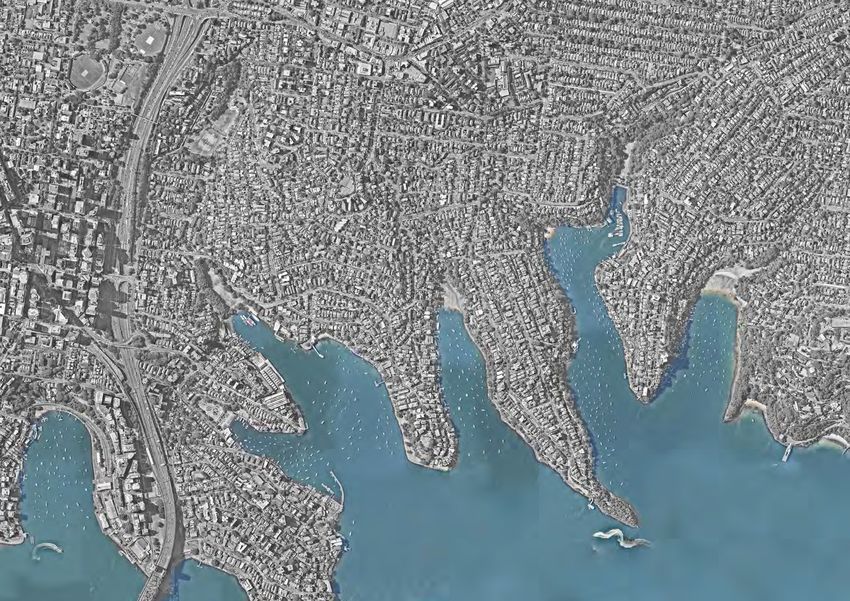
1.1 The Site
The site is located on Sydney’s north shore perched on
Kurraba Point. It is approximately two kilometers as-the-crow-
flies to the Central Business District although the fastest route
is via the Sydney Harbour Bridge or ferry across the water.
d
e
a
The site is within the North Sydney Local Government Area H
and has unique spatial relationships to the built form and yd
ro
Dob
landscape of the Mosman peninsula to the north as well as
the dynamic headlands to the south. The site enjoys iconic
views of both the Sydney Harbour Bridge and the Opera Mi No
dd
House on Bennelong Point. St Leonards le rt
Lane Cove h H
ead
He
Mosman
ad
Sout
h
H
e
Neutral Bay
a
d
North Sydney
R
U
t
Clar in
kes Po
Ku oi
O
re
P
C
rr n
B
ba m
a
t o
in orn
P
R
K t e
ir A
ib
d
Harbour Bridge
nt
illi oi H
ea
P B
ra
H
1km dleys Y
E Vaucluse
Opera House N
D
Balmain Circular Quay Y
S
nt Piper
2km oi
P
The Domain
ing Poin
rl t
a
D
CBD
Glebe Paddington Woollahra
4km
Central Station
SJB Context Presentation 2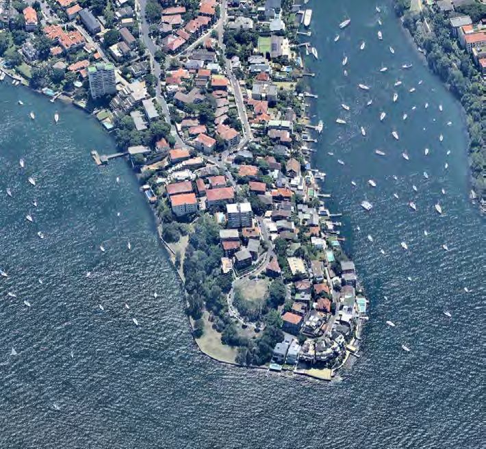
Place & Site

1.2    Site Photographs

The site is a combination of 147, 151, 153 Kurraba Road and
sits in the LGA of North Sydney. It is a prime location enjoying
panoramic views of Sydney Harbour and the CBD skyline
including the Opera House and Harbour Bridge. The nearby
F5 ferry takes passengers directly to Circular Quay via Kirribilli
offering quick connection to both North Sydney and The
City CBD. The site overlooks Hodgsons Park and Kurraba
reserve which provide recreational space for local residents
with views, direct connection to the water, and a childrens
playground.
                                             Kurrab
                                              a Road

                          151
                                    147

                         153

SJB                                                                  Context Presentation   3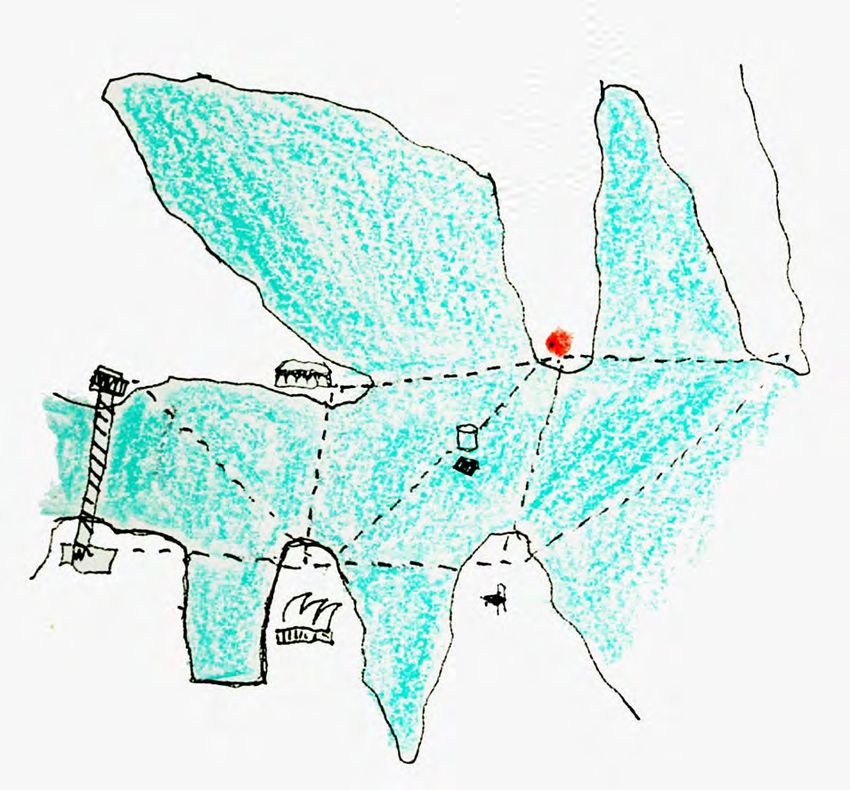
Place & Site
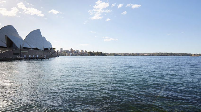
1.3 View from Royal Botanic Gardens
Site
SJB Context Presentation 4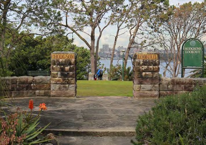
Place & Site

1.4    Site Observations

                                                                                                                                   Site

Sydney Harbour is the unifying element in the landscape, Kurraba Point and the             The ferry trip from Circular Quay to the site is the easiest and quickest mode of     The site is perched on a knoll on Kurraba Point headland next to a circular
site on its tip have a spatial and socio-cultural relationship to other points on the      public transport to the Sydney CBD. The trip to Kurraba Point Ferry stop presents a   road overlooking Hodgsons lookout. A dynamic sandstone cliff on the eastern
harbour. For thousands of years Australian Aboriginals enjoyed this landscape.             series of dynamic views of peninsular landmarks with the site constantly becoming     site boundary defines Kurraba Reserve which supports mature subtropical
Today The Opera House, Kirribilli House, Mrs Macquarie’s Chair and the Sydney              more prominent throughout the trip.                                                   vegetation and broad sunlit spaces. Large houses and apartments wrap from the
Harbour Bridge crown each ancient peninsula with Fort Denison suspended                                                                                                          southernmost tip of the headland eastwards around the peninsula.
between them.

SJB                                                                 Context Presentation                                                                                                                                                                         5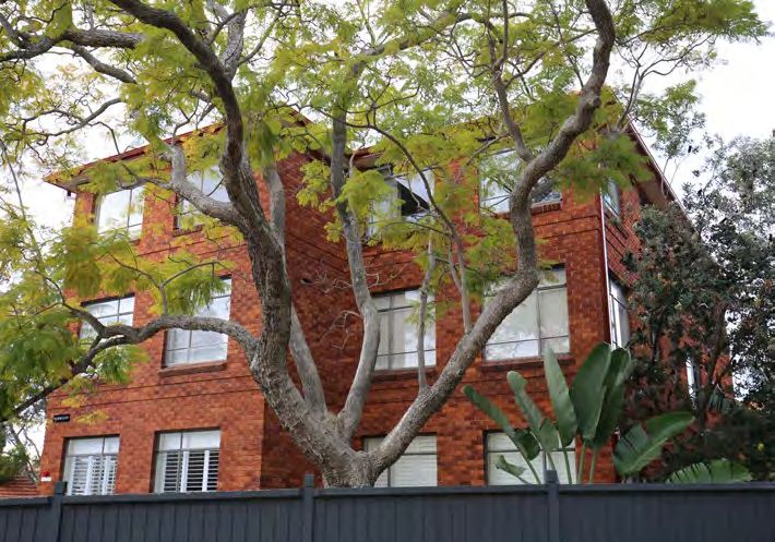
Planning Context
Project Name: 8355 - 147, 151 & 153 Kurraba Rd, Kurraba Point (PA)
Project Name: 8355 - 147, 151 & 153 Kurraba Rd, Kurraba Point (PA)
2
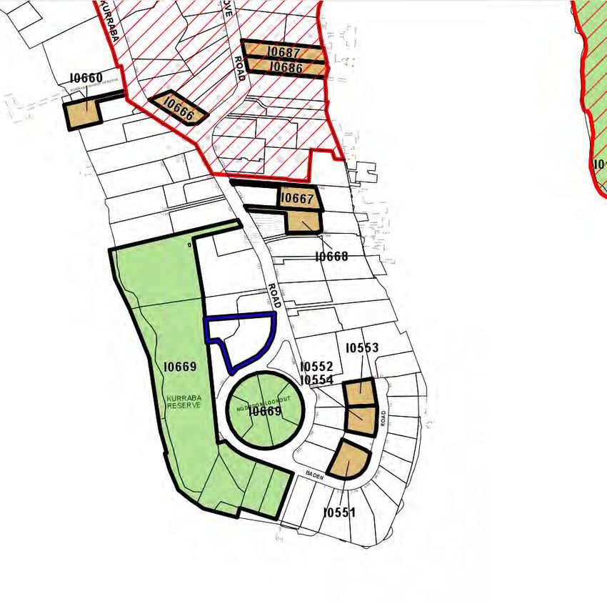
2.1 North Sydney LEP 2013
Project Name: 8355 - 147, 151 & 153 Kurraba Rd, Kurraba Point (PA)
The Site
The Site
8355_2_LEP Map Extracts
8355_2_LEP Map Extracts
2/3
SJB Planning
Land Zoning Heritage Height of Buildings
SJB Planning (NSW) Pty Ltd ACN 112 509 501
The site is located within the R4 High Density Residential land zone which allows The site is not located within a heritage conservation1 / area,
3 nor is it a local heritage The planning control for height of buildings on the site and directly adjacent to the
for
SJBaPlanning
number of development types including: Attached dwellings; Dwelling houses; item, however it is located adjacent to landscape heritage item I0669 - ‘Site and site is 12m.
Entertainment facilities;
SJB Planning (NSW) Pty Ltd ACN 112 509 Information
501 and education facilities; Multi dwelling housing; remains of Port Jackson and Manly Steamship Company Depot’, an Urban Park The Site
Residential flat buildings; located on Kurraba Road, Kurraba Point Reserve, including Hodgson and Spains
Objectives of the zone include: Lookouts.
8355_2_LEP Map Extracts
To provide for the housing needs of the community within a high density residential
8355_2_LEP Map Extracts
environment. To provide a variety of housing types within a high density residential
environment. To enable other land uses that provide facilities or services to meet
the day to day needs of residents. To encourage the development of sites for high
density housing if such development does not compromise the amenity of the
8355_2_LEP Map Extracts
surrounding area or the natural or cultural heritage of the area. To ensure that a
reasonably high level of residential amenity is achieved and maintained.
SJB Planning
SJB Planning (NSW) Pty Ltd ACN 112 509 501
8355_2_LEP Map Extracts
SJB Context Presentation 6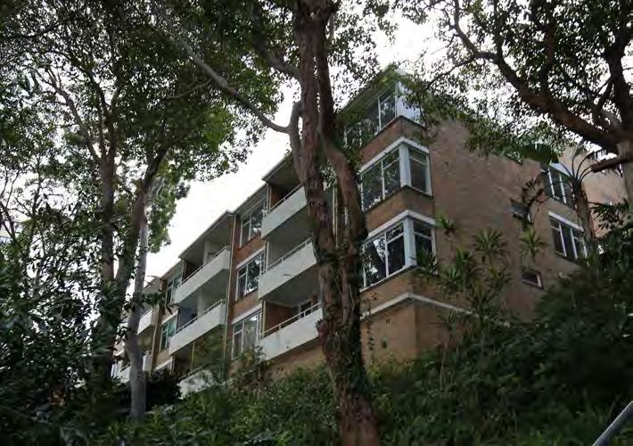
Planning Context

2.2      Development Control Plan

Key controls in the Development Control Plan include   Setbacks (4.6)                                                   Site Coverage (1.5.5)                                                Landscaped Area (1.5.6)
··   Setbacks / building height plane                  P1. The front setback must match the alignment of the            P2 For the purposes of P1, the following items are considered        P1 Provide minimum landscaped area and maximum un-built
··   Site coverage                                     primary façades of buildings on adjoining properties. Where      to constitute site coverage:                                         upon areas in accordance with Table B-1.7.
··   Landscaped area                                   different setbacks occur, the average of the setbacks of those   (a) buildings as defined by the EP&A Act 1979;
··   Kurraba Point South Neighbourhood                 primary facades is to be used.                                   (b) garages and carports;                                            P2 For the purposes of P1,
                                                                                                                        (c) sheds;                                                           (a) Landscaped area is considered to comprise all parts of a
                                                       P2. On land with a height of 12m or less:1.5m; and the           (d) enclosed / covered balconies, decks, pergolas and the            site used for growing plants, grasses and trees, but does not
                                                       building must not exceed a building height plane commencing      like;                                                                include any building, structure or hard paved area; and
                                                       at 3.5m above ground level (existing) from site boundaries       (e) swimming pools, spa pools and the like:                          (b) the following items are considered to constitute un-built
                                                       and projected internally to the site at 45 degrees.              (f) other structures including: (i) permanent BBQ structures; (ii)   upon area:
                                                                                                                        cabanas; (iii) external staircases; (iv) gazebos; (v) greenhouse/    (i) any part of a basement which does not comprise site
                                                       P5. Provide rear building setbacks that match those on           glasshouse; (vi) plant rooms; (vii) rainwater tanks; (viii) ramps;   coverage;
                                                       adjoining properties, or if adjoining properties are not         (ix) garbage storage facilities.                                     (ii) unenclosed balconies, decks, pergolas and the like;
                                                       characteristic, with setbacks identified in the relevant                                                                              (iii) paving and patios (porous and non-porous);
                                                       character statement.                                             However, site coverage excludes:                                     (iv) driveways and car stand areas (porous and non-porous);
                                                                                                                        (g) any basement;                                                    or
                                                       P6. Despite P5 above, buildings within the R4 zone:              (h) any part of an awning that is outside the subject site;          (v) water features.
                                                       a) Must be setback a minimum of 1.5m from the rear               (i) any eaves;
                                                       boundary; and                                                    (j) unenclosed balconies, decks, pergolas and the like;              However, un-built upon area excludes: (vi) anything else
                                                       b) Where the land is restricted by a height limit:               (k) paving and patios (porous and non-porous);                       defined as site coverage; or (vii) anything else comprising
                                                       i) Of 12m or less, must not exceed a building height plane       (l) driveways and car stand areas (porous and non-porous);           landscaped area.
                                                       commencing at 3.5m above ground level (existing) rear            (m) water features; or
                                                       boundary and projected at an angle of 45 degrees internally      (n) anything else defined as landscaped area.
                                                       to the site (refer to Figure B-1.3).

SJB                                                    Context Presentation                                                                                                                                                                                7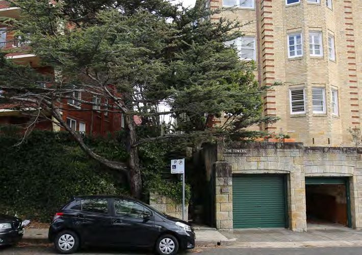
Planning Context

2.3      Neighbourhood Character

Kurraba Point South Neighbourhood (6.1)

Views
P8 The following views and vistas are to be preserved and
where possible enhanced:
(a) views from streets and reserves to Sydney Harbour and
beyond
(b) Hodgson lookout (41), Spains lookout (42), Kurraba Wharf
lookout (43)

6.1.2 Desired Future Character
Diversity

P1 Primarily medium to high density residential
accommodation, generally comprising
attached dwellings, multi dwelling housing and residential flat
buildings according to
zone.
P2 Limited opportunities for low density housing, generally
comprising dwelling houses
and dual occupancies.
P3 Any increases in density should be concentrated in the
vicinity of Kurraba Wharf.

6.1.3 Desired Built Form
Siting

P1 Buildings address both the street, as well as the foreshore.

P2 In narrow streets, towards rear boundary (subject to
foreshore building line) to
produce a more open streetscape
P3 Sites should provide front setbacks to allow for soft
landscaping.
Colours and materials

P4 Development adjoining foreshore or bushland areas (such
as at Wonga Road) use
muted colours and non-reflective materials, such as brick and
timber to ensure the
scenic and environmental qualities are enhanced.

SJB                                                               Context Presentation   8
Sugarloaf
Bay Cabbage Tree
Bay
BALGOWLAH HEIGHTS
Planning Context WILLOUGHBY Manly Cove
Sailors Bay
CLONTARF
NORTH
NORTHBRIDGE
HA
ARTARMON R BO
U
R HARBOUR
NORTH
NORTH HARBOUR
H
AR
BO
HARBOUR
y
Ba
U
ng
NAREMBURN
R
Lo
y
Ba
n g
Lo
2.4 Sydney Regional Environmental Plan (Sydney Harbour Catchment) 2005 CAMMERAY
ST LEONARDS
Hunters Middle
Bay Harbour
Shepherds CROWS NEST Hunters
Bay CREMORNE Bay
LONGUEVILLE CREMORNE
MOSMAN PA R
NORTHWOOD GREENWICH R AM
A TT
WOLLSTONECRAFT A
Obelisk
GREENWICH Shepherds
Bay NEUTRAL BAY
Bay Mosman
Bay
South
Obelisk NORTH SYDNEY
Woodford Head
TASMAN
Balls Head
y
WOLLSTONECRAFT WAVERTON
Bay
Ba
Bay Sydney Regional Environmental Plan Bay Lady
Brays Bay
M o Ba y
Lady MOSMAN
sh
CREMORNE POINT
Kissing Pt Bay
(Sydney Harbour Catchment) 2005
bu
Bay Little
rri
KURRABA POINT
me
Bay NEUTRAL BAY Sydney Opera House Buffer Zone Sirius
Ho
s on
Brays Bay
M o Ba y
BayPt
Kissing
Map (Amendment 2016)
SEA
Shell
rri
Neutral
s
GREENWICH Bay
Cove
s on
Bay
LANE COVE RIVER VE
RMCMAHONS POINT
Camp
s
Camp RI LAVENDER BAY Taylors
Cove Bay
B a d es
NORTH SYDNEY Mosman Cove
ay
B a d es
Berrys y
aB
Bay
Ba
a
y
l
a
Bay
Gl
lla
y
r al Chowder
N
Gl
Chowder Lavender Careening ra
Ya
Ya
SO
Balls Head WAVERTON Bay Bay Cove RIV E
RIV EBay
Legend Bay R
CK
WOOLWICH R CREMORNE POINT Little
ay
BIRCHGROVE MILSONS POINT
JA
sB
Sirius
KURRABA POINT WATSONS BAY
ay
Sydney Opera House Site
The
or
Bay
BALGOWLAH HEIGHTS
sB
Gap
Watsons
aj
Neutral Shell KIRRIBILLI
LAVENDER BAY Athol
M
Bay Cove Sydney Opera House Buffer Zone
or
WILLOUGHBY Bay
Berrys Watsons
Taylors Bay
aj
MCMAHONS POINT Taylors
Bay Foreshores and Waterways Area Boundary
M
Bay
Berrys
Cockatoo Island Bay Neutral Bay ck
Bay Lavender Careening Bay France Do
Bay Cove
Shark ve a y
CLONTARF Bay Bradleys Fi B
Head
Parsley GOAT Bay NORTH
He
MILSONS POINT NORTHBRIDGE
ck Bay ISLAND
CK
na
BIRCHGROVE HA
Do
ARTARMON R
DU
Athol
France KIRRIBILLI
nd
BO
ve a y SPECTACLE ISLAND
Bay Shark U
GREENWICH
Fi
Ch
R
Bay B Bay Vaucluse HARBOUR
Exile Bay
ic k
Bay NORTH HARBOUR
Mort
en
GOAT ISLAND
He
Bay FORT
Ba
Bennelong
DAWES POINT DENISON
y
na
Bradleys
ND
GOAT
SNAPPER ISLAND Head
Point
nd
ISLAND SYDNEY
BIRCHGROVE OPERA
RT
Ch
FORT DENISON (Pinchgut)
y
HOUSE
LANE COVE
Ba
Exile Bay Sydney BALMAIN EAST
PO
ic k
ng
NAREMBURN
Lo
R ISLAND
Mort
Cove
e
ve
Sydney
Hermit
nB
Bay DAWES POINT FORT
Bennelong VAUCLUSE
Co
THE ROCKS
ay
DENISON BALMAIN Cove
Sydney Regional Environmental Plan
Point
Bay
Da rli ng Ha
ay
MILLERS POINT
oB
Farm SHARK ISLAND THE
Cove Sydney Regional Environmental Plan
o lo
(Sydney Harbour Catchment) 2005
SHARK BARANGAROO
ROCKS
Darling Harbour
BALMAIN EAST I SLAND
(Sydney Harbour Catchment) 2005
om o
Sydney Farm
BALMAIN
Bay
n
Foreshores and Waterways
Cove Circular Quay
Ir o
THE ROCKS Hermit CAMMERAY Cove
ol l o
CLARK
rbour
Sydney Opera House Buffer Zone
oloo
Bay
CLARK ISLAND
ay
MILLERS POINT ST LEONARDS ISLAND
Wo
sB
Area
RODDMap
o mo
ISLAND
Darling Harbour
Map (Amendment 2016)
on
Middle
llo
Farm Royal Hunters
Harbour
GREEN
Woo
y
ns t
Botanical Bay
o Ba
Cove
ay
CLARK ROZELLE Gardens
sB
Jo h
CROWSElizabeth
oolo
ISLAND Felix
NEST
on
Bay
Rose
m
Bay
n st
lloo
CREMORNE
Sheet 3 of 5 (Amendment 2016)
Joh
Double Bay
Woo
Rushcutters
y
LONGUEVILLE POTTS POINT
Ba
ROZELLE Bay SYDNEY MOSMAN
ns
Bay Elizabeth
ns to
NORTHWOOD Bay
SYDNEY
Joh
POINT PIPER Obelisk
POTTS POINT GREENWICH PYRMONT Bay Blackburn
Elizabeth
Bay Cove
Legend Blackburn
Cove
Rose
Bay WOOLLOOMOOLOO Legend
ELIZABETH BAY
South
Double Head
PYRMONT ELIZABETH BAY WOLLSTONECRAFT ZONE NAME DARLING POINT Bay
Double
Lady BIRCHGROV
¹
Rushcutters Bay
Sydney Opera House Site
¯
Foreshores and Waterways Area Boundary Bay
DOVER HEIGHTS W1 Maritime Waters Bay
ENVIRONMEN
WOOLLOOMOOLOO Rushcutters NEUTRAL BAY
Bay
W2300Environmental Protection Legend
RUSHCUTTERS BAY
Local Government Area DARLING POINT 0 150 450 600
m
Sydney Opera House Buffer Zone
Projection: MGA Zone 56
RUSHCUTTERS BAY Camp DOUBLE BAY
W3 Naval Waters
Datum: GDA94 Scale: 1:17,500
@ A3
DOUBLE BAY ROSE BAY Foreshores and Waterways Area Boundary DARLINGHURST Foreshores and Waterways
Cove Area Boundary
NORTH SYDNEY Mosman
ULTIMO
Bay BELLEVUE HILL
Map Identification Number
W4 Aviation GLEBE
Local Government Area SURRY HILLS Chowder
EDGECLIFF
PADDINGTON
SYDNEY REG
DARLINGHURST Balls Head WAVERTON HAYMARKET Bay
Bay
GLEBE
EDGECLIFF WOOLWICH W5 Water Recreation CREMORNE POINT Little
Foreshores and Waterways area map ULTIMO
HAYMARKET Zoning Map BELLEVUE HILL
LAVENDER BAY
W6 Scenic Waters Neutral
Active Use
KURRABA POINT
Opera House Buffer
Shell
Sirius
Bay
0 375 750 1,500 2,250 3,000
WATSONS BAY The
Gap (SYDNEY H
Bay Cove
ANNANDALE
FOREST LODGE MCMAHONS POINT W7 Scenic Waters Casual Use Taylors
Bay
Metres Watsons
Bay BIRCHGROV
Berrys
NORTH BONDI
Bay Lavender W8 Scenic Waters Passive Use
Careening
The site is located within the Foreshores and Waterways Area Boundary PADDINGTON
The waterway surrounding Kurraba Point is zoned as Maritime Waters
8a National Parks
Bay Cove
The site is located just inside the Sydney Opera House Buffer Zone. The objectives Parsley
MILSONS POINT
of this plan in relation to the Sydney Opera House
by :are:
SURRY HILLS
¯
Bay
Mo
CHIPPENDALE ENVIRONMENTAL PLANNING AND ASSESSMENT ACT, 1979 WOOLLAHRA KIRRIBILLI Drawn Bay N. Chand
Athol
Shark
Ba
a) to establish a buffer zone around the S.O.H. so asNo.
G.I.S. Dwg. 0402
Bay Vaucluse
BONDI BEACH to give added protection to its Bay
SPECTACLE ISLAND
GOAT
world heritage value Department file No. ..................
Bradleys
Head
Planning Officer: U. Williamson
CAMPERDOWN DARLINGTON BIRCHGROVE ISLAND
RE
REDFERN
BONDI
SNAPPER JUNCTION
ISLAND
BONDI
Mort
Bay DAWES POINT Bennelong
b) to recognise that views and vistas between
FORT
ManagertheG.I.S.
S.O.H. and other public
VAUCLUSE
places
...................
SYDNEY REGIONAL ENVIRONMENTAL PLAN County: value. Cumberland
DENISON
within that zone contribute to its world heritage
Point
MOORE PARK
BALMAIN
EVELEIGH
Parish: Various SHARK
(SYDNEY HARBOUR CATCHMENT) 2005
NEWTOWN BALMAIN EAST I SLAND
L.G.A. Various
Sydney
BALMAIN TAMARAMA Cove
1,500 2,250 3,000
THE ROCKS Hermit
WAVERLEY
Bay
ZONING MAP Date: 27:06:2005
QUEENS PARK
MILLERS POINT
Metres
WATERLOO
Darling Harbour
Farm
Locality: Various
y
o Ba
Cove
CLARK
Catalogue. ..................
oolo
ISLAND Felix
Bay
m
lloo
Woo
y
Ba
ROZELLE
ns
ns to
SYDNEY
Joh
POINT PIPER
POTTS POINT
Elizabeth
Bay
ROZELLE
sB
on
Blackburn Rose
Cove Bay
n st
PYRMONT ELIZABETH BAY
Joh
Double
Bay
WOOLLOOMOOLOO DOVER HEIGHTS
Rushcutters
Bay
DARLING POINT
RUSHCUTTERS BAY
DOUBLE BAY ROSE BAY
DARLINGHURST
SJB Context Presentation GLEBE
EDGECLIFF
9
ULTIMO BELLEVUE HILL
HAYMARKET
ANNANDALE
FOREST LODGE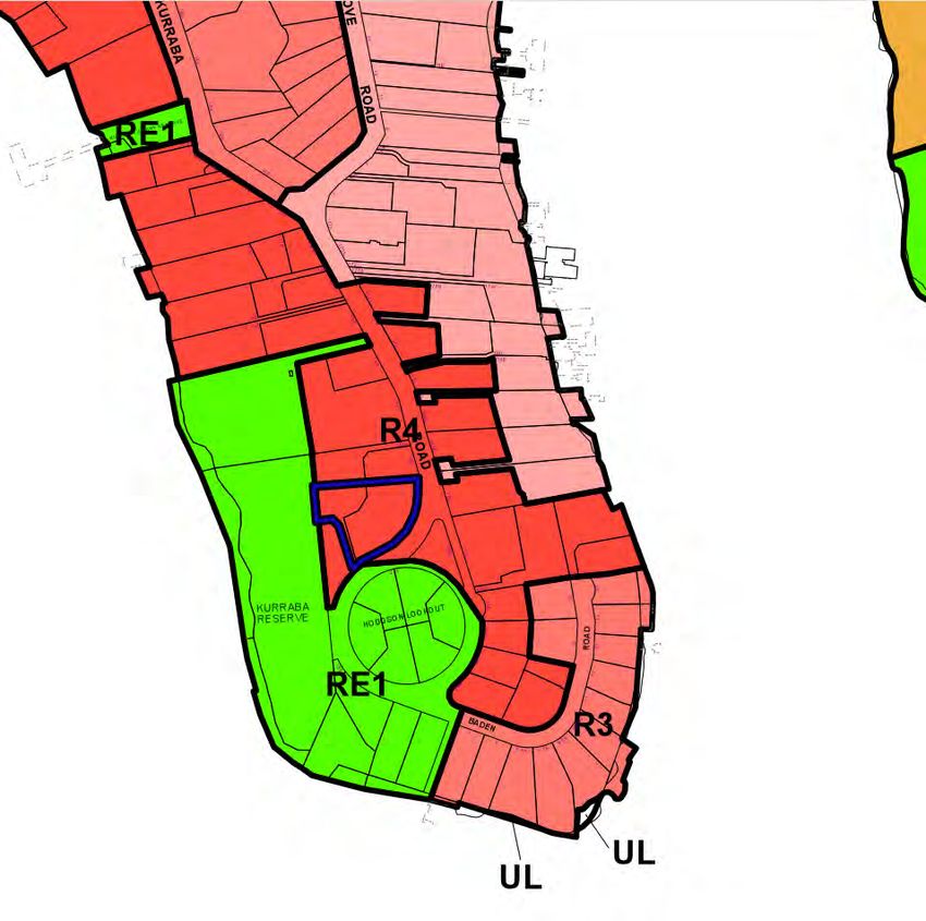
Analysis
3
3.1 Urban Context
The site sits on the southern tip of Kurraba Point with the
suburbs of Neutral Bay to the north and Cremorne Point
Mosman Village
to the east. North Sydney and Neutral Bay Village are both Neutral Bay Village
approximately 1.6km away, both offering major supermarkets,
transport connections and significant employment services 160
0m
and shops. A system of circuitous primary roads knit together
the peninsulas into the Cahill Expressway to the Sydney
CBD. A network of ferry stops also connects pedestrians and C R E M O R N E
cyclists to Circular Quay.
120
0m
S O U T H M O S M A N
N E U T R A L B A Y
North Sydney 80
0m
C
K U
R
E
R R
M
O
North Sydney Station
A B
R
40
0m
N
A
E
Taronga Zoo
P
P O
O
I N
N T
T
Milsons Point Station
Kirribili Village
K I R R I B I L I
SJB Context Presentation 10Analysis
3.2 History & Place
The Office of Environment and Heritage register historic A B
notes for I0669 (shown on the LEP map below) ‘Kurraba
Point Reserve was originally a foreshore sandstone quarry,
established around 1850 to supply stone for the construction
of Fort Denison. Later, after quarrying ceased, the flat
foreshore shelf was utilised by the Port Jackson and Manly
Steamship Company or a ferry maintenance, repair and
administration depot. It was an important base of operations.
The company was sold to the State Government in 1974. The
site has been cleared and grassed and made a recreation
reserve. Hodgson Lookout commemorates a Mayor, T.W.
Hodgson, 1901-1903 and Spains Lookout commemorates a
local identity and alderman, S.W. Spain. A searchlight battery
was located at Hodgson Lookout for a period during World
War II’.
Photograph A shows the rocky condition of the west edge
Project Name: 8355
of Kurraba Point- 147,
when 151it&was
153 Kurraba
used asRd,
theKurraba Point (PA)
ferry maintenance
depot with larger manor houses perched on the ridge
above. The more densely developed peniunsula is shown in
photograph C from the interwar period. Aerial photograph B
shows the extensive naval repair and fuelling infrastructure on
the point during World War II.
C
The Site
8355_2_LEP Map Extracts
2/3
SJB Planning
SJB Planning (NSW) Pty Ltd ACN 112 509 501
SJB Context Presentation 11Analysis
3.3 Transport & Movement
Sydney’s lower north shore road network is defined by
circuitous primary streets running east west following the
undulating topography and transverse north-south streets
Nurdich Roa
connect the extend along ridgelines to the harbour headlands.
The site is within a 400m walk to Kurraba Road Ferry Stop
Ben Boyd Road
which takes 10 minutes to Circular Quay Wharf and departs
Avenue Road Ferry
d
every 30 minutes. The 225 and 263 bus routes are within 800
800m of the site and take 25 minutes to reach the CBD. m
Wyc
om
A t
be R
h o
oad
l
Kurra
ba R
B a
oad
y
Old Cremorne Ferry
400
m
Neutral Bay Ferry
M o
N
e
u
s m
t Kurraba Point Ferry
r
a
a n
l South Mosman Ferry
H
a
r
B a
b
o
u
y
r
North Sydney Ferry
Site
Primary street
Cremorne Point Ferry
Secondary street
Tertiary street
Walking path Kirribilli Ferry
Bus route
Ferry stop
SJB Context Presentation 12Analysis
3.4 Landscape & Open Space
Kurraba Point is part of the broader dendritic system of
north-south harbour peninsulas and coves. Sandstone ridges
extend into the harbour with intersecting coves carved by
streams taking rainwater from the Mosman peninsula above
into the harbour. The coves are densely vegetated tidal
microclimates often with public spaces such as Anderson
Park. The site is within walking distance of many parks and
800
playgrounds and enjoys close proximity to Cremorne Point m
Walking Path and Maccalums Baths swimming pool. The site
is adjacent to Hodgsons lookout and Kurraba Reserve which
are RE1 and heritage listed and have excellent views of the
A t
harbour, seating, a playground and kayaking faclities.
h o
l
Anderson Park
B a
y
400 Curraghbeena Reserve
m
Hayes St Beach
M o
N
e
u
s m
t
r
a
Cu
McCullum Baths Pool
a n
Cre
l
H
rr
mo
a
ag
r
rne
B a
b b
h
o e
Poi
Kesterton Park u en
Cr
y
a P
nt W
r
em
oint
or
Milson Park
alki
ne
Po
ng
Kurraba Reserve
int
Hodgsons Lookout
Pat
W
Wur nt
rabiri Poi
alk
h
ngi
Pa
th
Ku
rra
ba Point
Site
Open space (RE1)
---- Tidal cove microclimate Cremorne Reserve
R
---- Sandstone ridge o
b
er
---- 1m contours ts
on
Swimming Pool s P
oint
Playground
Kayak Facilities
SJB Context Presentation 13Analysis
3.5 Built Form & Height
Kurraba Point has a range of residential building typologies
and heights. Immediately to the north on the western side of
the peninsula are taller residential flat buildings of mostly 3-6
storeys. The southern end of the point is wraped by large
houses between 3 and 6 storeys in height. Further back to
the north, most buildings are detached houses between 1
and 4 storeys. A tall block of apartments which is 9 storeys in
height sits two lots north of the site. The view plane analysis
undertaken later in this report is from the south facing
balconies of this building.
Kurra
ba R
oad
Site
Residential flat building
Detatched house
1-2 storeys
3-4 storeys
5-6 storeys
7+ Stories
SJB Context Presentation 14Analysis
3.6 Site Coverage
The sites within the locality exhibit a high percentage of site
coverage resultant from low and high density residential uses.
Immediately to the north of the subject site exist 2 residential
buildings at the upper end of the site coverage scale; one of
40-60% of its site and the other of 60-80% of its site. This is
a commonly seen condition along Kurraba Road and across
Hodgsons Lookout Park.
Site
0-20% coverage
20-40% coverage
40-60% coverage
60-80% coverage
SJB Context Presentation 15Analysis
3.7 Architectural Character
A wide range of architectural styles are present on Kurraba 1 2 3
Point owing to the fact it was settled in the late Victorian era
and consolidated through the 1930’s. Photograph 2 and 8
demonstrate typical 1920’s and 30’s dark brick Sydney Art
Deco apartments. Photograph 9 shows curved bay windows
and balconies typical of the interwar period. Mediterranean
influences are present in the apartments shown in photos 3
and 7. Popular 60’s and 70’s red and yellow brick modernist
apartments are shown in photos 1 and 4. Clean lined modern
architecture is demonstrated at different scales with the
garage oriented house in photo 5 and the tall balcony lined
apartments in photo 6.
4 5 6
7 8 9
1
2 3
4
5
6
7
8
9
SJB Context Presentation 16Analysis
3.8 Site Frontage & Edge Conditions
1 Upwards sloping footpath, parking access and onsite 1 2 3
carparking of the tall apartments of 143 Kurraba Road
2 Staggered garage entrances constructed from
sandstone create and interesting and tactile street
frontage with apartments set back above.
3 Pedestrian access for rear apartments via a landscaped
staircase. The mature pine and vineclad wall establishes
an atmospheric entrance to the buildings.
4 Vantage point from across the street highlights the
curved site boundary and raised landscape plinth on
which the current buildings sit.
5 The landscaped wall defines site boundary and the
public and private domain. Two apartment blocks are
connected by a service core with onsite carparking at
the base of the buildings. 4 5 6
6 Paved car driveway for 151 Kurraba Road behind.
Significant has excavation created the change in levels
between the three buildings.
7 Rectangular and curved mass of 153 Kurraba Road with
a landscape setback.
8 A mature fig tree occupies the tapered south tip of the
site.
9 Kurraba Road continues downwards towards the water
with views of Kirribilli and Sydney CBD to the south
west.
7 8 9
1
2
3
4
5
6
7
8
9
SJB Context Presentation 17Analysis
3.9 Constraints & Opportunities
Ku
Ku
rra
b
rra
aR
aRb
oad
oad
12pm
3p m
m 9a
Hodgsons Lookout Hodgsons Lookout
Kurra
Kurra
ba R
ba R
eserv
eserv
e
e
Constraints Opportunities
Site Site
Listed heritage considerations Sandstone platform could be integrated into the design
Noise from ferry and Kurraba Reserve Existing trees establish a sense of character and history
>>> One way traffic Vegetated cliff interface creates a green privacy buffer
Complex topography limits site access points off Kurraba Road Topography steps down site allowing many internal architectural configurations
Opera House Buffer Zone Curved site boundary creates a dynamic street interface
Interface with Kurraba Reserve Morning harbour breezes from the west
Narrow rear setback & privacy considerations Afternoon harbour breezes from the east
Level change & interface on Kurraba Road Solar exposure
Overshadowing and minimisation of view obstruction of tall building to the north Views of the Neutral Bay and the Sydney Harbour Bridge
Potential overshadowing of Kurraba Reserve and Hodgsons Lookout Views of the Sydney skyline and Opera House
Views looking to the eastern headlands
Site overlooks public open spaces
SJB Context Presentation 18Analysis
3.10 Views & Height of Buildings
The building heights along Kurraba Point range from 2 to 17
storeys. The average building height is 5.5 storeys. Buildings
along the headland use terraces volumes and balconies
to maximise views over Sydney Harbour, Neutral Bay and
Kirribilli Point. Aligning new development to existing height
and building envelopes will ensure the continuity of urban
form along the peninsula.
17 9
Site
5
9 6 3 3 4
2 2 6 6 5 4 3
12m Max Building Height
View of Kurraba Point from Kirribilli
Site
12m maximum building height
SJB Context Presentation 19Design Principles & Site Massing
4Design Principles & Site Massing
4.1 Principles & Site Response
Landscape & Urban Context Built Form Views & Orientation Landscaping Solar Access & Amenity Materiality
The design process should consider the The massing form and architecture Internal layout should maximise views Mature existing vegetation should be Room layout should maximise solar Local topography, flora, history and
dynamic landscape and urban context should be site specific and of Sydney Harbour and the city skyline retained and integrated into the design access for living rooms and comply with site should inform the materials used
at every scale. Qualities such as the integrate development controls and behind. A balance between privacy and where possible. Native plants should local council controls and the Apartment to construct the building. Sydney
history, landscape, nearby ferry, mature programmatic needs. The form should passive surveillance of Kurraba Rserve be prioritised and used to delineate the Design Guidelines. Morning and sandstone alongside concrete, brick
trees and iconic sandstone can inform complement the unique existing place and Hodgsons Lookout should be nature of different spaces within the afternoon harbour breezes should be and wood should be used in a manner
architectural elements from concept but also be definitive in its expression on achieved. building and on the edges of the site. harnessed to provide cross ventilation harmonious to its streetscape and
facade design to fine interior detailing. the headland. The exposed sandstone should also be for apartments. broader context. Detailing should
celebrated through landscape design. reference the history of the place.
SJB Context Presentation 21Design Principles & Site Massing
4.2 Massing Strategy
ad
ad
ad
ba Ro
ba Ro
ba Ro
Kurra
Kurra
Kurra
Retained Shared Views Match Building Alignment Retain Scale and Fine Grain of Existing Context
Road
ad
ad
ba Ro
ba Ro
ba
Kurra
Kurra
Kurra
Maximise Outlook Landscaped perimeter and large courtyard Maximise Solar Access
SJB Context Presentation 22Concept Diagrams
5
5.1 Schematic Options
143 143 143 143 143
145 145 145 145 145
145B 145B 145B 145B 145B
Kurraba Re
Kurraba Re
Kurraba Re
Kurraba Re
Kurraba Re
ad ad ad ad ad
Ro Ro Ro Ro Ro
ba ba ba ba ba
rra rra rra rra rra
Ku Ku Ku Ku Ku
serve
serve
serve
serve
serve
Existing Option 1 - North-South Alignment Option 2 - East-West Alignment Option 3 - Tower Option 4 - Horse Shoe
143 143 143 143 143
145B 145B 145B 145B 145B
Hodgsons Hodgsons Hodgsons Hodgsons Hodgsons
oad oad oad oad ad
Lookout Park
aR
Lookout Park
aR
Lookout Park
aR
Lookout Park
aR
Lookout Park
a Ro
r rab r rab r rab r rab r rab
Ku Ku Ku Ku Ku
SJB Context Presentation 235.2 Existing
View Sharing Outlook Landscape Solar
Views predominantly east-west Existing outlook condition for 147, 151 and 153 Minimal landscaping due to grade carparking and siting Multiple buildings producing large shadowed area
Views to the south from the upper levels of 143 Kurraba Kurraba Road of buldings on small lots Poor solar amenity
road
143
145B
Hodgsons
ad
Lookout Park
a Ro
r rab
Ku
SJB Context Presentation 24Concept Diagrams
5.3 Option 1
View Sharing Outlook Landscape Solar
Existing views maintained Potential overlooking Opportunity for significant landscaping but Poor solar amenity
Potential for views south across site overshadowed by building volumes
143
145B
Hodgsons
ad
Lookout Park
a Ro
r rab
Ku
SJB Context Presentation 25Concept Diagrams
5.4 Option 2
View Sharing Outlook Landscape Solar
_Existing views slightly reduced to 145A Kurraba Road _Predominantly East-West outlook _Limited opportunity for significant landscaped areas _Poor solar amenity
_Potential overlooking
143
145B
Hodgsons
ad
Lookout Park
a Ro
r rab
Ku
SJB Context Presentation 26Concept Diagrams
5.5 Option 3
View Sharing Outlook Landscape Solar
_Increased view access for 145 and 145A Kurraba _High level of access to available views _Potential for significant landscape _Limited solar access
Road.
143
145B
Hodgsons
ad
Lookout Park
a Ro
r rab
Ku
SJB Context Presentation 27Concept Diagrams
5.6 Option 4
View Sharing Outlook Landscape Solar
_Existing views maintained _Opportunity to capitalise on available views _Central courtyard green space _Opportunity for solar access via dual orientated living
_Potential for overlooking _Northern and southern green spaces areas
143
145B
Hodgsons
ad
Lookout Park
a Ro
r rab
Ku
SJB Context Presentation 28SJB Architects sjb.com.au We create spaces people love. SJB is passionate about the possibilities of architecture, interiors, urban design and planning. Let’s collaborate. Level 2, 490 Crown Street Surry Hills NSW 2010 Australia T. 61 2 9380 9911 architects@sjb.com.au sjb.com.au
You can also read