CAMERON PEAK FIRE RISK ASSESSMENT - Larimer County
←
→
Page content transcription
If your browser does not render page correctly, please read the page content below
LARIMER COUNTY OFFICE OF EMERGENCY MANAGEMENT
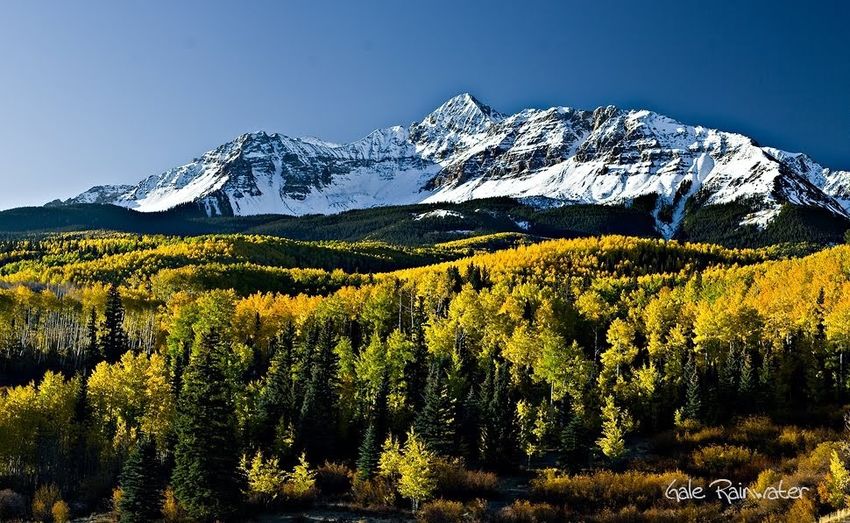
CAMERON PEAK FIRE
RISK ASSESSMENT
Summary results of the Cameron Peak Fire Risk
Assessment and Hydrology Analysis
May 2021
Para obtener información en español
sobre los esfuerzos de recuperación y
los recursos para el incendio de
This summary report has been devel- Cameron Peak, comuníquese con
oped to provide community members Ricardo Perez al (970) 498-7142 o por
with information contained in the correo electrónico
a perezri@co.larimer.co.us.
Cameron Peak Fire Risk Assessment
that was completed by Larimer County
during the winter of 2020-2021.
200 W. Oak St. ● Fort Collins, CO 80501 ● 970.498.7000 ● Larimer.org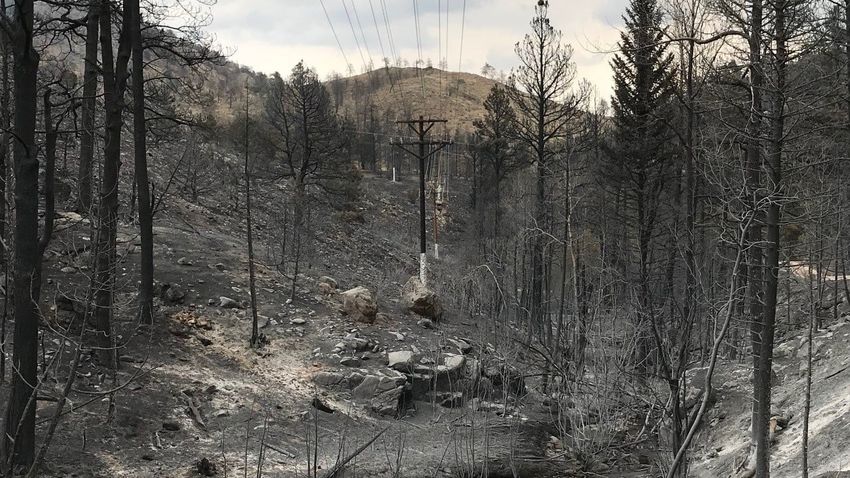
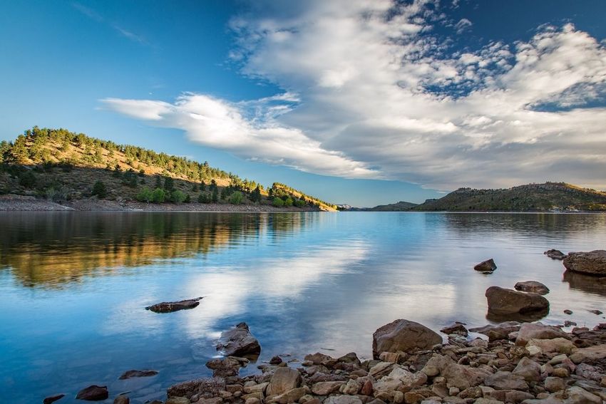
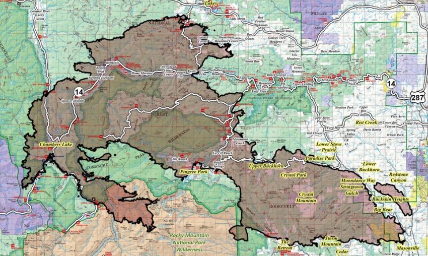
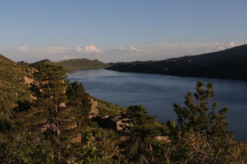
Purpose of the Risk Assessment
The Cameron Peak Fire was reported on Thursday, August 13, 2020. The fire burned an
area of 208,913 acres over several months in Larimer County, affecting both private and
public lands until being fully contained on December 2, 2020. Weather and fuel conditions
influenced fire growth, behavior, and effects of the Cameron Peak Fire. Extreme tempera-
tures, low humidity, rough terrain and gusty winds reaching over 70 miles per hour were
just some of the elements that were contributing factors influencing fire development.

Within its burn perimeter, the Cameron Peak Fire reduced or eliminated above ground
vegetation cover and altered soil structure, resulting in varying degrees of post-fire hydro-
phobicity. These direct changes to vegetation, structure, composition, and density will lead
to reduced precipitation interception, decreased soil infiltration capacity, and elevated
runoff compared to pre-fire conditions. The Soil Burn Severity (SBS), soil erosion, hydrolo-
gy, and debris flow modelling results obtained and used in the risk analysis indicate that
post-fire there will be an increase in watershed response. This means:
• Increased erosion and sedimentation
• Areas that flood or had debris flows pre-fire will have larger magnitude events
• Areas that occasionally flood or had debris flows pre-fire will see more frequent events
• Areas that previously did not have streamflow or debris flow may now flood or have de-
bris flows
• Private and public infrastructure are at an increased risk of damage to post-fire flood
events
• Additional impacts to aquatic and terrestrial habitats are likely to occur

Priority areas are defined as neighborhoods or watershed basins that have a comparatively
high probability of flooding, water quality issues, and debris impacts to County and private
assets based on available data. In addition to priority area identification, the assessment
also provides specific mitigation methods that could be proactively implemented during
the emergency response phase to protect life, property, and the environment.
Risk Assessment Criteria
Larimer County conducted the Risk Assessment of the Cameron Peak Fire burn area to de-
termine levels of risk for communities and to determine possible actions to minimize post-
fire flood impacts. The Risk Assessment used information from a variety of sources and ex-
panded upon the Burned Area Emergency Response (BAER) report completed by the Unit-
ed States Forest Service.

Priorities for the Larimer County Risk Assessment:
1) Life Safety—Threats to human life
2) Property Protection—County Roads, Private Roads, Homes and other Buildings
3) Environmental Protection—Water Quality, Flora, Fauna, Soil Productivity and Historic or
   Cultural Resources

In order to meet these priorities, the county focused on analyzing the following areas:
•   Neighborhood Analysis—The County used the Neighborhood Pod maps established by
    the Emergency Services agencies to analyze specific neighborhoods within the fire area.
•   Debris Flow Analysis—The county analyzed data regarding potential debris flow areas
    to determine impacts to infrastructure, lives and property.
•   Public Road Infrastructure—The County analyzed all road infrastructure within the fire
    area, including roads, culverts, bridges, and downstream impacts.
•   Private Road Infrastructure—The County analyzed private roads at risk from flooding
    and debris flows.
•   FEMA Floodplains—The County analyzed FEMA Floodplain locations in relation to possi-
    ble flood risks.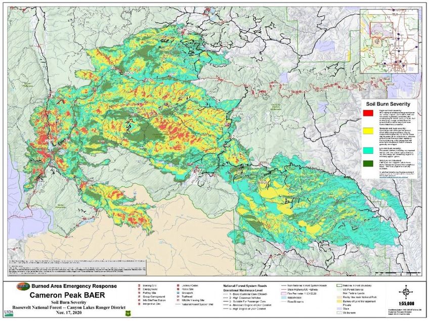
Data Sources
Geospatial data employed in the risk analysis were obtained from multiple cooperating
agencies. These include Larimer County, the Coalition for the Poudre River Watershed
(CPRW), Colorado Forest Restoration Institute (CFRI), Northern Water, U.S. Forest Service
(USFS), U.S. Geological Survey (USGS), and U.S. Fish and Wildlife Service (USFWS). Data
employed in the risk analysis include the Cameron Peak Fire final burn perimeter and Soil
Burn Severity (SBS) mapping, infrastructure, neighborhood access points, roads, hydrogra-
phy, land use, slope, and debris flow modeling.

Mapping and Risk Analysis
Neighborhoods, county road segments, private roads, residences, culvert, and bridge
locations were provided by Larimer County. USFS provided Soil Burn Severity mapping.
USGS provided potential debris flow lines. FEMA and Larimer County provided (pre-fire)
mapped flood zone areas.
Data output were typically ranked from most-impacted to least-impacted to allow prioriti-
zation, and graphed in histograms where appropriate to visualize the results and compare
relative potential impacts across locations. Those areas deemed at “High” risk typically
occur within the top 20% of the results for each asset class examined. The risk ranking
developed in the report is thus relative, and not absolute. This methodology was used to
rapidly identify those areas that have the highest potential risk associated with the post-
fire environment, and to guide subsequent emergency actions.
Ground-truthing was conducted through general observation of soil burn severity, slopes
and drainages within potential debris flow areas, and evidence of prior flooding along
stream corridors in close proximity to structures and road infrastructure. Ground-truthing
was primarily conducted to affirm assumptions related to the data, to inform prioritiza-
tion of mitigation areas, and to assist with development of risk mitigation recommenda-
tions.
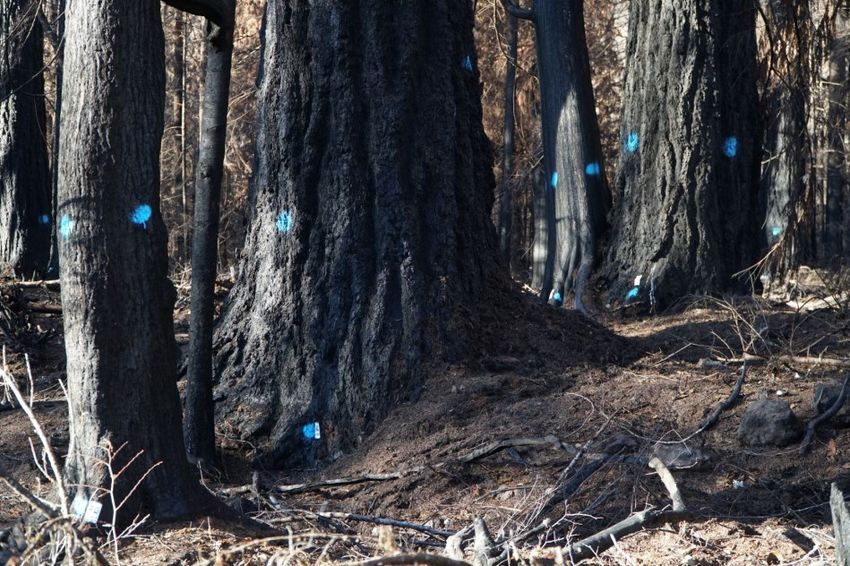
Neighborhood POD Burn Severity

We started with Burn Severity in Neighborhood Pods.
LOW severity areas generally have intact and recognizable litter layers (organic material on
the forest floor, such as pine needles and twigs). These litter layers may be charred, but are
not consumed. Underlying topsoil is intact and near-surface fine roots are unburned. These
soils have enough cover to protect them from erosion during rain events because their nat-
ural porosity and structure allow rain to soak into the soil instead of running off.
MODERATE severity areas generally have more—up to 80% of their pre-fire surface litter
layers consumed by fire. Black or gray ash may be present on the soil surface. Fine roots
near the surface may be scorched and killed. Soils with moderate severity are more suscep-
tible to erosion in post-fire rain events because they have lost protective surface cover and
may have less surface stability because of root mortality.
HIGH severity areas generally have had all their pre-fire surface litter layers consumed by
fire. Fine roots are often fully burned/consumed within several inches of the soil surface,
and even large tree roots may have burned deep into the soil. Soil may be powdery or
grainy and loose, unable to bind together and retain water. These soils are very susceptible
to erosion and often have high surface run-off during rainstorms. - Source: Inciweb
Neighborhood Soil Burn Severity
The assessment of neighborhood and post-fire burn severity resulted in the identification
of 10 neighborhoods that experienced a significant amount (>10% of the neighborhood)
of Moderate- or combined High + Moderate burn severity.

These neighborhoods include the following:
- Crystal Mountain                           - Monument Gulch
- Crystal Park                               - Moondance Way
- Goodell Corner                             - Poudre City
- Home Moraine                               - Storm Mountain
- Lazy D Ranch                               - Upper Buckhorn
Neighborhood Debris Flow Data

Neighborhood Pods were assessed to determine the total length of potential debris flows
(length in feet) across all debris flow severities [High, Moderate, Low, or None] within each
of the 35 neighborhood polygons. In addition to analyzing by hazard class, the sum of all
hazard classes was calculated for each neighborhood.

This examination of neighborhoods by debris flow potential resulted in the identification of
8 neighborhoods that have potential to experience significant debris flows (>50,00 feet to-
tal) within the neighborhood pod.

These neighborhoods include the following: Big Bear, Crystal Mountain, Goodell Corner,
Monument Gulch, Red Feather Lakes, Redstone Canyon, Storm Mountain, and Upper Buck-
horn.
Neighborhood Flood Zone Assessment
Neighborhoods were assessed to determine the proportion of each neighborhood within a
FEMA flood zone. This includes the 100-year Flood Zone, the 100-year Floodway, and the
500-year Flood Zone.

This examination of neighborhood by FEMA Flood Zone resulted in the identification of 6
neighborhoods having a significant proportion (>20%) of the neighborhood located within
a mapped flood zone. These six neighborhoods include the following: Home Moraine,
Kinikinik, Pingree Park, Poudre City, Rustic, and Sleeping Elephant. A histogram depicting
the proportion of neighborhood pods located within a FEMA flood zone is presented be-
low (Figure 3). Neighborhoods represented by red bars represent those pods in the 20th
percentile. Neighborhoods represented by orange bars represent those pods in the top
40th percentile. The gray bars represent neighborhoods below the 40th percentile.
High Risk Neighborhoods
Based on the burn severity analysis, potential for significant debris flows, and percentage
of neighborhood area within a FEMA flood zone, the following neighborhood pods ranked
the highest comparatively, for post-fire flooding and debris flows:

  Big Bear                              Monument Gulch                   Upper Buckhorn
  Crystal Mountain                      Poudre City                      Storm Mountain
  Goodell Corner

NFIP Flood Insurance
Most homeowners insurance does not cover flood damage. Flood insurance is a separate
policy that can cover buildings, the contents in a building, or both, so it is important to pro-
tect your most important financial assets — your home, your business, your possessions.
The National Flood Insurance Program (NFIP) provides flood insurance to property owners,
renters and businesses, and having this coverage helps them recover faster when floodwa-
ters recede.
Flood insurance is available to anyone living in Larimer County. Homes and businesses in
high-risk flood areas should have flood insurance, especially after a wildfire impacts their
area. For more information about what’s covered and to find a policy visit:
FloodSmart.gov.
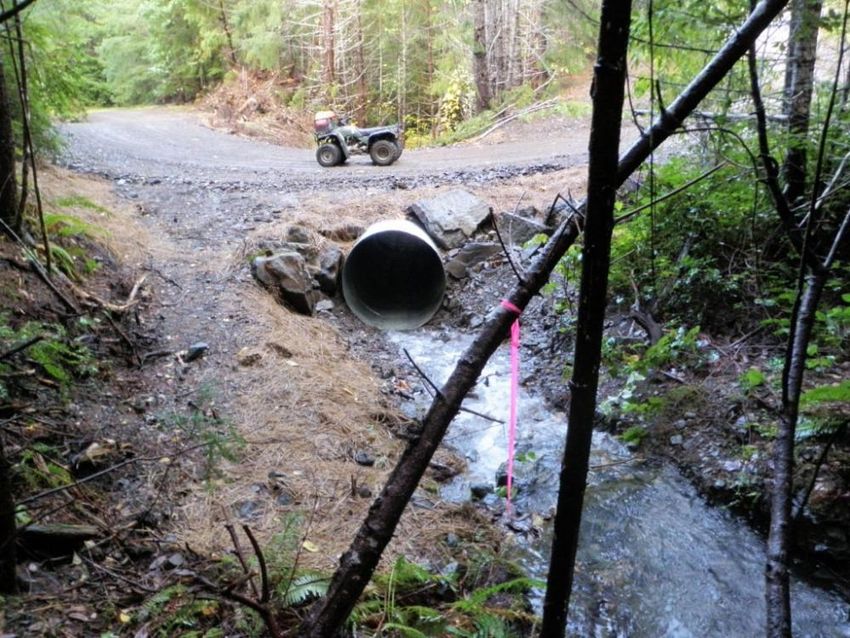
County Road Analysis
County Roads were assessed to determine:
1) the proportion of each County Road segment (segments were delineated as road sec-
   tions within the fire’s burn perimeter) within mapped burn severity classes [High,
   Moderate, Low, or Very Low/Unburned]; 2
2) the total number of locations where potential debris flow hazards [High, Moderate,
   Low, None] intersect with each road segment; and
3) the proportion of each road segment within a mapped FEMA flood zone.

County Roads that have been determined to be at high risk for debris flows and possible
flooding include portions of the following: Laramie River Road, Manhattan Road, Pingree
Hill, Buckhorn Road, CR 44H.

Private Road Analysis
Private roads were assessed similarly to the county roads, by assessing the road length
within the fire area, the proportion of road per degree of burn severity (percentage of
length), debris flow modeling, and the proportion of the road in a FEMA Floodplain. The
private roads most at risk include:
•Agate Court                               •Aspen Grove Hill Lane
•Broadtail Road                            •Calcite Court
•Cool Grove Lane                           •Crystal Mountain Road
•Forest Road 129                           •Granite Road
•Marpa Point Road                          •Monument Gulch Way
•Moondance Way                             •Quartz Road
•Stringtown Gulch Road                     •Skyline Ditch
•U Bar U Lane
Residence / Structure Analysis
Nine-hundred and twenty-eight (928) private residence or structures were provided by the
county for assessment. Structures were analyzed using a 200-foot buffer and using the
same methodology as the neighborhood pods, using soil burn, debris flow, and flood
potential to determine risk. Many residences and structures located in high and moderate
soil burn areas have been lost to the fire. Soil erosion due to soil burn severity poses a low
risk to structures. Debris flow and flooding present high risks. Potential flooding or debris
flows were found to be present within 200 feet of three-hundred and eighty-nine
structures.
Additional desktop and ground-truthing will be necessary to refine this analysis as many
structures flagged as having increased risk are located in suitable geomorphic positions
and therefore risk will be low.

County Road Culverts and Bridges
Six-hundred and twenty-five (625) county culverts and nine (9) bridge locations were
analyzed by the county. Culverts and bridges were analyzed using a 200-foot buffer and
using the same methodology as the county road segments, using soil burn, debris flow,
and flood potential to determine risk.
Two-hundred and fifteen (215) culverts and one (1) bridge are located in or within 200-feet
of moderate or high soil burn areas. Two-hundred and sixty (260) culverts and three (3)
bridges are located within 200 feet of potential debris flow areas. Ninety-four (94) culverts
and five (5) bridges are located with floodplains.
Soil erosion due to soil burn severity, debris flows, and debris laden floodwaters present
high risks to culverts and bridges.

Additional hydraulic analysis will help Larimer County refine prioritization of culvert and
bridge risk.
Hydraulics & Hydrology (H&H)
Larimer County requested assistance from the state to provide more detailed hydrologic
(predicted runoff flowrates from storm events) and hydraulic (predicted flow velocities,
depths, etc.) analyses of the entire burn area and potential downstream effects. This
analysis was completed at the end of April 2021. The conclusions drawn from the hydrol-
ogy report are surmised as follows:
•   Homeowners should understand that in addition to being in greater danger from rising
    flood waters from rivers and creeks (demonstrated by the hydrology report), some
    residents are also at greater risk of localized debris floods from upslope areas
    (demonstrated in the initial threat assessment), especially in steeper terrain because
    of the effects of the fire on vegetation and soil.
•   No models are 100- percent accurate, however calibrated hydrologic models help
    assess relative changes in runoff response between pre- and post-fire conditions under
    a variety of rainfall conditions. It is not possible to account for every variable for a
    given scenario (clogged culverts, boulders blocking stream channels) that could
    potentially alter the way water flows. As seen during the September 2013 floods,
    flooding and damages could occur outside the limits of mapped floodplains.
•   Assets located well outside of the burn perimeter may be at an elevated risk of poten-
    tial flood hazards. Flood impacts may extend as far as the crossroads of north County
    Road 23H and Highway 34 in southeast Loveland on the Big Thompson River and as far
    as northeast of Bellvue/LaPorte on US14 approaching County Road 29C on the Poudre
    River.
•   Many homes already at risk within the 100-year regulatory floodplain along the
    Poudre and Big Thompson Rivers, are at an elevated level of risk – increased depths of
    flow and velocity of flow - because of the fire.
•   All residents within the Burn Perimeter should take the necessary precautions and pay
    close attention to alerts for potential floods, know escape routes and, if trapped, flee
    to higher ground.
•   The ranking of high priority areas where the County is proposing to do potential
    mitigation work was influenced by the results of the hydrology report. Certain project
    areas were expanded to include the analysis of structures outside and downstream of
    the burn perimeter expanding the initial risk area.
Varying Flood Types Flash Floods in streams draining into small, steep watersheds can involve mixtures of wa- ter and sediment in varying proportions. Three basic flow processes are generally recog- nized in streams: Water Flow – The amount of suspended sediment is insufficient to substantially affect how flowing water behaves. Water may appear very muddy; but most of the sediment is transported near the bed. Depending upon flow velocities, depths and durations of flood- ing and channel bed material composition, erosion of the channel and banks can occur. Hyper-concentrated Flow – The amount of suspended sediment is sufficient to signifi- cantly change fluid properties and sediment transport mechanisms. Large volumes of sand are transported throughout the water column. Flows can be highly erosive and can impact how flows are predicted to behave. Debris Flow – Sediment and water mixture becomes a slurry, similar to wet concrete, ca- pable of holding gravel-sized particles when flowing slowly or stopped. In steep canyons, flow can achieve high velocities, transport large boulders, and cause catastrophic damage from impact or burial. In low-gradient channels and on alluvial fans flow can be slow, im- peded by drier, coarse sediment at the flow margins, but it can nevertheless rapidly infill channels, divert streams, and destroy automobiles, buildings, and infrastructure.
Areas of Greatest Concern

Rustic / Poudre City / Glen Echo/Goodell Corner—Risks include flooding associated with Seven Mile
Creek and debris flows within multiple steep and narrow canyons with relatively large watershed areas.
Water quality impact risks are very high in this area.
Monument Gulch / Pingree Park Road / Lazy D Ranch—Risks include flooding associated with Fish
Creek, Pennock Creek, Little Beaver Creek, and the South Fork of the Poudre River. Debris flow risk is
high within Monument Gulch. Water quality impact risks are very high in Fish Creek, Little Beaver Creek,
and the Monument Gulch areas.
Upper Buckhorn / Crystal Mountain / Crystal Park—Risks include flooding associated with Buckhorn
Creek and debris flows within multiple relatively steep and narrow canyons with relatively large water-
shed areas. Single point access to structures in this area is common and many of the access roads lie
within canyons with elevated risk.
Storm Mountain / Retreat—Risks include flooding associated with Black Creek, Miller Fork, and the
North Fork of the Big Thompson. Debris flow and erosion potential exists for both the Storm Mountain
and Retreat neighborhoods. Single point access to structures in this area is common and many of the
access roads lie within areas of elevated risk. The entire Storm Mountain neighborhood relies on one
access located within a steep and narrow canyon, however the contributing watershed is outside of the
burn area.
Areas of Greatest Concern—Streams
Below is a table listing the streamways in Larimer County with the highest predicted
percent increase in flow rates. Each rain event will impact the fire area differently. Just
because a streamway is not on this list, does not mean that streamway will not see a
significant flood event. Caution is needed in and around all streams and rivers in the
coming years due to the impacts from the Cameron Peak Fire.
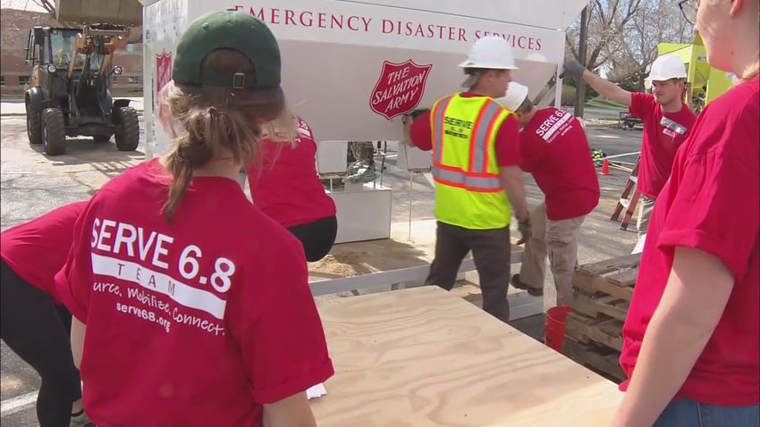
Sandbag Availability
Special thanks to Serve 6.8 and their volun-
teers for providing sandbags for the Cameron
Peak Fire area. All sandbags were delivered
mid-May. Dumpsters are also available for
FIRE-RELATED debris through July 31st. For a
map of sandbag and dumpster locations,
please use the following link:
Sandbag and Dumpster LocationsPotential Mitigation Methods
The following list includes methods and actions that can be used to reduce risk to Life and Safety,
Property, and the Environment during the emergency response phase:
• Upgrading and fortifying road infrastructure – culvert and bridge replacement, adding rip-rap
to road shoulders, resurfacing.
• Planning for road infrastructure repair – planning for rapid culvert or bridge replacement or
maintenance in the event of stormwater/floodwater induced damage or failure.
• Increasing monitoring and maintenance of roadways – installation of cameras and/or stream
monitoring devices at stream-road intersections, increased fallen-rock/debris-flow/fallen tree
patrols following large and intense rain events, regular maintenance of stormwater convey-
ance (ditches and culverts).
• Removing debris from streams to prevent damage to bridges and culverts and damage from
increased flooding.
• Removing danger trees to prevent potential emergency vehicle access disruption, traffic haz-
ard, local access, and structure damage.
• Installing warning signs to notify motorists, bikers, and hikers they are entering a burn area
subject to flash flooding and debris flow hazards.
• Structure protection to prevent potential flood or debris flow damage.
• Soil stabilization to prevent soil particle detachment as a result of rain, wind, and gravity.
• Slope protection and upland channel protection to prevent sediment and ash from eroding
into waterways or onto roadways or structures.
• Sediment basin construction to collect sediment and ash prior to washing into waterways.
• Stream bank stabilization
• Revegetation / Reforestation – revegetation planning, planting of native vegetation, monitor-
ing, and treating invasive species. Seeding of sterile annual cereal grains (e.g., triticale) should
also be considered in disturbed locations to prevent colonization by invasive species and
serve as a living mulch.Planning and Implementation
Larimer County Engineering Department
The Larimer County Engineering Department is in the
process of designing several culvert replacements and road/
stream bank fortification projects.
Larimer County Emergency Management—Debris
Removal and Danger Tree Mitigation
Hazardous Tree Removal began on May 24, 2021 in
streamways and along both public and private road
systems to decrease the possibility of blocked
egress in the fire area.
Larimer County Emergency Management—
Structure Protection
Larimer County Office of Emergency Manage-
ment is in the process of detailed analysis and a
ground-truthing exercise to further refine the
address list that contain structures placed in
areas of concern for flooding and/or debris flow
damage and life safety concerns. The County is
in the process of designing structure protection measures and notifying homeowners.
Larimer County Emergency Management—Soil Stabilization and Slope Protection
Larimer County has identified 4 priority areas for the installation of erosion control wattles
for slope and channel protection along county and private roadways, along waterways,
and above structures at greatest risk from debris flows. Property owners will be notified,
and voluntary mitigation options will be presented such as wattle installation, mulching,
and/or seeding with a cover crop.Limitations & Future Considerations The risk assessment was completed as part of an emergency response action to identify potential areas of elevated hazard quickly and efficiently. The focus was on exigent threats to life, property, and the environment at a broad scale within the burn perimeter. No portion of the burned area exists in isolation, and a holistic management perspective is important. Cumulative effects (upstream to downstream) have the potential to be signifi- cant drivers of risk given the expansive area and rugged topography encompassed by the burn perimeter, and these need to be carefully considered moving forward. Emergency Response-phase projects will transition to long-term post-fire rehabilitation efforts. The Long-Term Recovery and Restoration Phase will utilize non-emergency actions to improve fire-damaged lands that are unlikely to recover naturally and to repair or replace infrastructure damaged by the fire that are not critical to life and safety. This phase may include restoring burned habitat, reforestation, other planting or seeding, monitoring watershed effects, treating noxious weed infestations, addressing recreational needs, implementing projects to enhance watershed resilience and sustainability, and addressing other long-term priorities. This long-term recovery phase should focus on present and future community needs, watershed health and sustainability, and the desired future conditions of landscapes impacted by the Cameron Peak Fire.
For more information:
         Larimer County Office of Emergency Management
                         (970) 498-7120
                        oem@larimer.org
               www.larimer.org/wildfire-resources

200 W. Oak St. ● Fort Collins, CO 80501 ● 970.498.7000 ● Larimer.org
You can also read