State of Alabama
Ambient Air Monitoring
  2021 Network Plan

     May 14, 2021
←
→
Page content transcription
If your browser does not render page correctly, please read the page content below
State of Alabama
Ambient Air Monitoring
2021 Network Plan
May 14, 2021
Table of Contents
Definitions and Acronyms ............................................................................................................. iii
Introduction ..................................................................................................................................... 1
Public Review and Comment.......................................................................................................... 1
Overview of Alabama’s Air Monitoring Network.......................................................................... 2
Summary of adjustments and proposals for the ADEM AAQMP .................................................. 3
   Summary of changes in 2020/2021............................................................................................. 3
   Summary of proposed changes for 2021/2022 ........................................................................... 3
Network Plan Description ............................................................................................................... 5
Monitoring Requirements ............................................................................................................... 6
Population and CBSA ..................................................................................................................... 6
Types of Monitoring Stations ......................................................................................................... 9
   CASTNET................................................................................................................................... 9
   NCore .......................................................................................................................................... 9
   PAMS.......................................................................................................................................... 9
   SLAMS ....................................................................................................................................... 9
   SPM............................................................................................................................................. 9
   SO2 DRR .................................................................................................................................... 9
   STN ............................................................................................................................................. 9
   Supplemental Speciation ............................................................................................................. 9
ADEM’s Monitoring Networks by Pollutant ................................................................................ 10
   Carbon Monoxide (CO) Network ............................................................................................. 10
   Lead (Pb) Network.................................................................................................................... 10
   Nitrogen Dioxide (NO2) Network ............................................................................................. 10
   Ozone (O3) Network ................................................................................................................. 11
      Ozone Monitoring Requirements for Alabama MSAs ......................................................... 12
   PM2.5 Network ........................................................................................................................... 14
      PM2.5 Monitoring Requirements for Alabama MSAs ........................................................... 16
   PM10 Network ........................................................................................................................... 18
   Sulfur Dioxide (SO2) Network ................................................................................................. 18
   Quality Assurance ..................................................................................................................... 19
ADEM AAQMP Pollutant Network Tables ................................................................................. 20
Appendix A ................................................................................................................................... 24
   Site Assessments ....................................................................................................................... 24
Appendix B ................................................................................................................................... 41
   Notice of Site Relocation .......................................................................................................... 41

                                                                  Page i of iii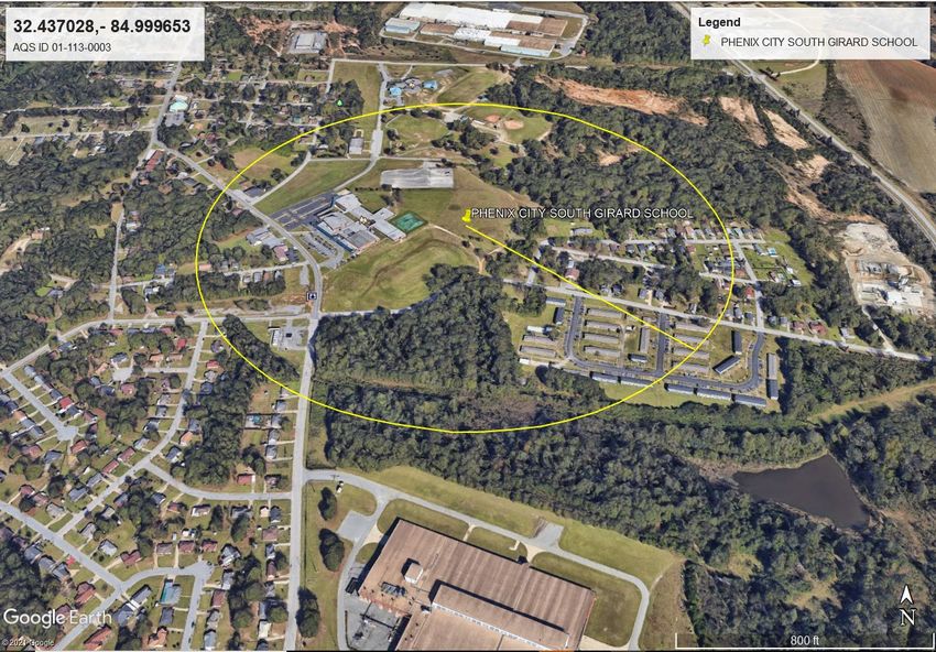
List of Tables
Table 1 2021 ADEM Ambient Air Monitoring Network ............................................................... 4
Table 2 Alabama CBSAs ................................................................................................................ 7
Table 3 SLAMS Minimum Ozone Monitoring Site Requirements .............................................. 11
Table 4 ADEM Ozone Monitoring Sites and Design Values ....................................................... 11
Table 5 PM2.5 Minimum Monitoring Site Requirements .............................................................. 14
Table 6 ADEM PM2.5 Monitoring Sites and Design Values......................................................... 15
Table 7 SO2 Minimum Monitoring Site Requirements ................................................................ 19

List of Figures
Figure 1 Alabama MSAs and ADEM Monitoring Sites ................................................................. 8

                                                           Page ii of iii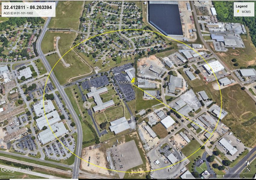
Definitions and Acronyms
AADT          Annual Average Daily Traffic
AAQM          Ambient Air Quality Monitoring
AAQMP         Ambient Air Quality Monitoring Plan
ADEM          Alabama Department of Environmental Management
ARM           Approved Regional Method
AQS           Air Quality System
avg           average
CBSA          Core Based Statistical Area
CFR           Code of Federal Regulations
CO            Carbon Monoxide
CSA           Combined Statistical Area
CSN           Chemical Speciation Network
EPA           Environmental Protection Agency
FEM           Federal Equivalent Method
FRM           Federal Reference Method
HDNREM        Huntsville Division of Natural Resources and Environmental Management
hr            hour
hi-vol        high-volume sampler
JCDH          Jefferson County Department of Health
low-vol       low-volume particulate sampler
m3            cubic meter
min           minute
ml            milliliter
MSA           Metropolitan Statistical Area
NAAQS         National Ambient Air Quality Standards
NCore         National Core multipollutant monitoring station
O3            ozone
PAMS          Photochemical Assessment Monitoring Station
Pb            lead
PM            particulate matter
PM2.5         particulate matter ≤2.5 micrometers diameter
PM10          particulate matter ≤10 micrometers diameter
ppb           parts per billion
PQAO          primary quality assurance organization
PSD           Prevention of Significant Deterioration
PWEI          Population Weighted Emissions Index
QA            Quality Assurance
QAPP          Quality Assurance Project Plan
QC            Quality Control
SLAMS         State or Local Air Monitoring Station
SO2           Sulfur Dioxide
SPM           Special Purpose Monitor
STN (PM2.5)   Speciation Trends Network
tpy           tons per year
TSP           Total Suspended Particulate
URG           URG-3000N PM2.5 Speciation monitoring carbon-specific sampler
°C            degree Celsius
μg/m3         micrograms (of pollutant) per cubic meter (of air sampled)
µSA           Micropolitan Statistical Area
≥             greater than or equal to
>             greater than
≤             less than or equal to
<             less than

                                            Page iii of iii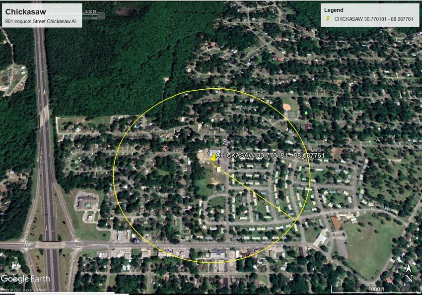
Introduction
In October 2006, the United States Environmental Protection Agency (EPA) issued final Federal
Regulations (40 CFR Part 58) concerning state and local agency ambient air monitoring networks.
These regulations require states to submit an annual monitoring network review to EPA. This
document provides the framework for establishment and maintenance of Alabama’s air quality
surveillance system, lists changes that occurred during 2020/2021, and changes proposed to take
place to the current ambient air monitoring network during 2021/2022.
Public Review and Comment
The annual monitoring network review must be made available for public inspection for thirty (30)
days prior to submission to EPA. For 2021, this document was placed on ADEM’s website on
05/15/2021 to begin a 30-day public review period. This document can be accessed at the following
link:

                    http://www.adem.state.al.us/newsEvents/publicNotices.cnt

Or by contacting:
                                           Gina L. Curvin
                                          ADEM FO MGY
                           P.O. Box 301463, Montgomery, AL 36130-1463
              (Street address: 1350 Coliseum Boulevard, Montgomery, AL 36110-2059)
                             Or by e-mail at gcurvin@adem.alabama.gov

                                               1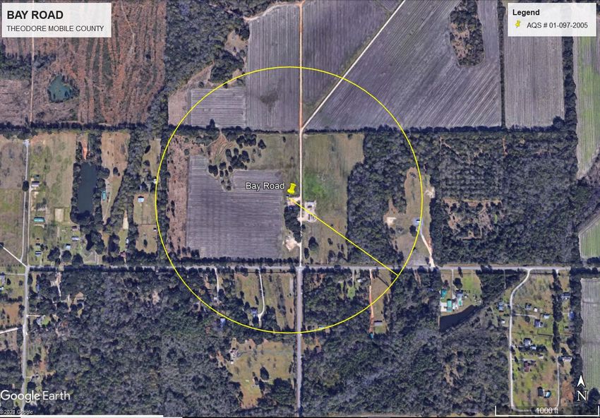
Overview of Alabama’s Air Monitoring Network
Ambient air monitors in the state of Alabama are operated for a variety of monitoring objectives.
These objectives include determining whether areas of the state meet the National Ambient Air
Quality Standards (NAAQS), to provide public information such as participation in EPA's AirNow
program, Air Quality Index (AQI) reporting for larger Metropolitan Statistical Areas (MSAs), for
use in Air Quality models, and to provide data to Air Quality Researchers. Entities in Alabama
monitor all six (6) criteria pollutants which have NAAQS identified for them: Carbon Monoxide
(CO), Lead (Pb), Nitrogen Dioxide (NO2), Ozone (O3), particulate matter (PM10, PM2.5), and Sulfur
Dioxide (SO2). PM2.5 speciated compounds, a non-criteria pollutant, is also monitored for special
purposes. In addition, meteorological data may also be collected to support air monitoring and aid
in analysis of the ambient air monitoring data.

In Alabama, the air quality surveillance system is operated by three separate entities: the Alabama
Department of Environmental Management (ADEM), and two local agencies, the Jefferson
County Department of Health (JCDH), and the Huntsville Department of Natural Resources and
Environmental Management (HDNREM). Each agency is responsible for its own annual network
plan. This document reflects only the ADEM air quality surveillance system. An overview of the
2021 ADEM Monitoring Network can be found in Table 1.

The JCDH plan will be available for review on their website by following this link.
https://jcdh.org/SitePages/Misc/AirProgReports.aspx

The HDNREM plan will be available for review on their website by following this link.
https://www.huntsvilleal.gov/environment/air-quality/

Currently, the Air Quality Index (AQI) is reported for Huntsville, Birmingham, Mobile,
Montgomery and Phenix City on the Internet at the sites listed below.

    ADEM        http://adem.alabama.gov/programs/air/airquality/ozone/historical.cnt

    JCDH        https://jcdh.org/SitePages/Programs-Services/EnvironmentalHealth/Air-
                RadiationProtectionDivision/AirQualForecast.aspx

    HDNREM      https://www.huntsvilleal.gov/environment/air-quality/air-pollution-
                control-program/air-quality-daily-index-reports/

.

                                                2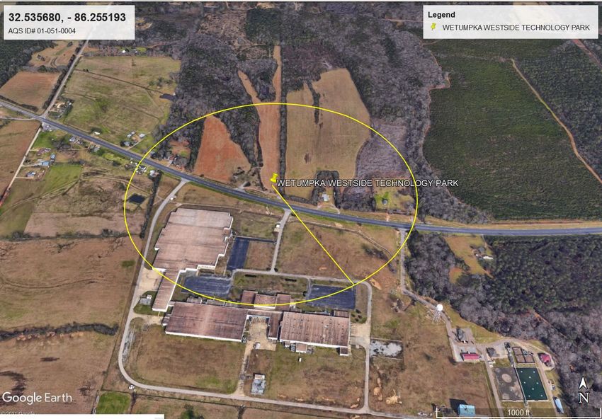
Summary of adjustments and proposals for the ADEM AAQMP
Summary of changes in 2020/2021
Decatur, AQS ID 01-103-0011, a FEM API T-640 replaced a non-FEM BAM-1020 for
continuous PM2.5 monitoring was scheduled for March 2020. Due to COVID related
delays, the monitor replacement did not become effective until August 1, 2020.
Phenix City – South Girard School, AQS ID 01-113-0003, PM2.5 monitoring with two
local FRM samplers, primary and collocated, both collecting on a 1 in 3 day schedule and
a continuous FEM BAM-1022 monitor was changed. On January 1, 2021, only two
samplers remain at the site, the continuous FEM PM2.5 BAM-1022 was designated as the
primary PM2.5 SLAMS monitor and one local FRM sampler that collects on a 1 in 6 day
schedule meet the collocation requirements. The other local FRM sampler was removed.
VA, Tuscaloosa, AQS ID 01-125-0004, a local FRM sampler was added to meet
collocation requirements of PM2.5 monitoring on January 1, 2021. The primary local FRM
sampler collects on a 1 in 3 day schedule and the collocated local FRM sampler collects on
a 1 in 6 day schedule.
Ward, Sumter Co., AQS ID 01-119-0003, On January 1, 2021, the FEM BAM-1022
PM2.5 SLAMS monitor replaced the non-FEM BAM-1020 for continuous PM2.5
monitoring. As this monitor will be the second continuous FEM monitor in the network,
no collocation of a FRM is required at this site.
Summary of proposed changes for 2021/2022
Duncanville, Tuscaloosa, AQS ID 01-125-0010, ADEM has lost access to the property
and this ozone site is scheduled to close once the replacement site is fully operational. A
new ozone monitoring site will be operational within this MSA before this site is closed.
Duncanville Middle School, AQS ID 01-125-0011 will replace Duncanville,
Tuscaloosa, AQS ID 01-125-0010. The replacement site is located 1.3 miles west of the
closing site. A new CAS shelter will be delivered in May and monitoring is expected to
begin July 1, 2021. ADEM will request a continuation of the data for design value
purposes. See Appendix B for supporting documentation.
Chickasaw, AQS ID 01-097-0003, Both the primary FRM manual monitor and the non-
FEM BAM 1020 will be shut down on December 31, 2021 and be replaced by a continuous
FEM BAM-1022 PM2.5 monitor. Beginning January 1, 2022, the continuous FEM BAM-
1022 PM2.5 SLAMS monitor will be designated as the primary monitor at the site.
Although two monitors will be shut-down, no change in the number of pollutants
monitored will occur as result of this change of equipment. This upgrade to continuous
FEM equipment is inline with plans outlined in the 5-year Network Assessment.
Ward, Sumter Co., AQS ID 01-119-0003, On January 1, 2022, ADEM is scheduled to
begin monitoring NO2 at Ward, Sumter Co. (AQS ID 01-119-0003) as a background site.
The monitor will be designated as a Special Purpose Monitor (SPM).
3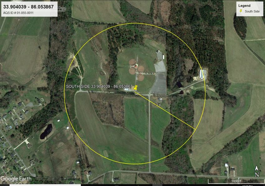
Table 1 2021 ADEM Ambient Air Monitoring Network

                                                                                                                                                                         PM10 Lo-Vol Collocated
                                                                                           PM 2.5 Local Collocated

                                                                                                                                                                                                             Lead TSP Collocated
                                                                                                                                        PM2.5 Continuous
                                                                                                                     PM2.5 Speciation

                                                                                                                                                           PM10 Lo-Vol
                                                                             PM2.5 Local

                                                                                                                                                                                                  Lead TSP
                                                                     Ozone

                                                                                                                                                                                                                                   NO2

                                                                                                                                                                                                                                         SO2
ADEM Site Common Name                             AQS ID
Fairhope                                          01-003-0010         X X
Ashland                                           01-027-0001                  X
Crossville                                        01-049-1003                  X
Wetumpka Westside Technology                      01-051-0004         X
Gadsden C College                                 01-055-0010                  X
Southside                                         01-055-0011         X
             4                                                           4
Chickasaw                                         01-097-0003         X X                                                               X4                                                                                               X
Bay Road                                          01-097-2005         X
MOMS, ADEM                                        01-101-1002         X X X                                                               X X X
Decatur                                           01-103-0011         X X                                                                 X
Troy Lead                                         01-109-0003                                                                                                                                      X X
Phenix City - South Girard School                 01-113-0003         X                         X X                                       X
Helena                                            01-117-0004         X
Lhoist, Montevallo Plant (DRR)                    01-117-9001                                                                                                                                                                            X
Ward, Sumter Co.3                                 01-119-0003         X                                                                   X                                                                                        X3 X
VA, Tuscaloosa                                    01-125-0004                  X X
                              1                                         1
Duncanville, Tuscaloosa                           01-125-0010        X
                                  2
Duncanville Middle School                         01-125-0011        X2
1. Duncanville, Tuscaloosa will close once Duncanville Middle School is fully operational
2. Duncanville Middle School is scheduled to begin ozone sampling 07/01/2021
3. Ward is scheduled to begin NO2 sampling 01/01/2022
4. The primary monitor will change to continuous & FRM closed on 01/01/2022

                                                        4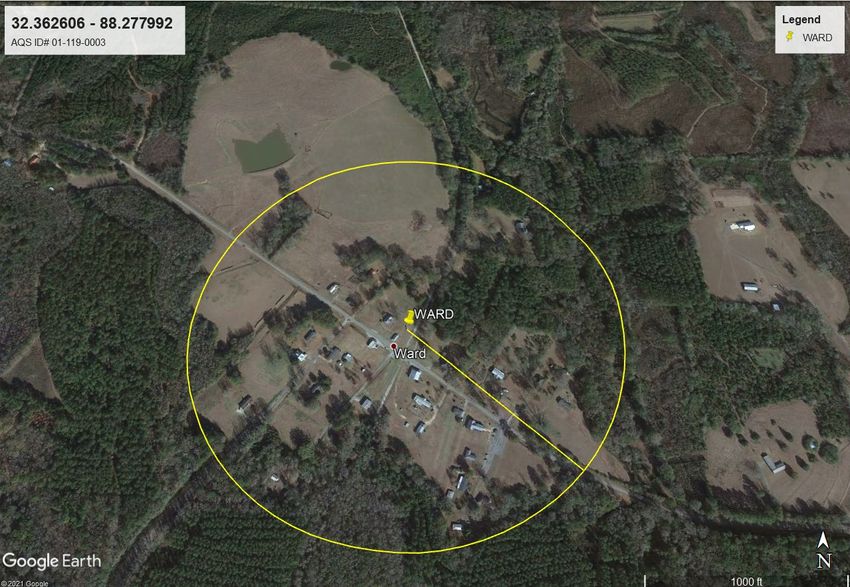
Network Plan Description
As per 40 CFR Part 58.10, an annual monitoring network plan which provides for the
establishment and maintenance of an air quality surveillance system consisting of the air quality
monitors in the state is required to be submitted by all states to EPA.

Specifically §58.10 (a) requires for each existing and proposed monitoring site:
   1. A statement of purpose for each monitor.
   2. Evidence that siting and operation of each monitor meets the requirements of Appendices
       A, C, D, and E of 40 CFR Part 58, where applicable.
   3. §58.10 (b) requires the plan contain the following information for each existing and
       proposed site:
       a. The Air Quality System (AQS) site identification number.
       b. The location, including street address and geographical coordinates.
       c. The sampling and analysis method(s) for each measured parameter.
       d. The operating schedules for each monitor.
       e. Any proposals to remove or move a monitoring station within a period of 18 months
           following plan submittal.
       f. The monitoring objective and spatial scale of representativeness for each monitor.
       g. The identification of any sites that are suitable and sites that are not suitable for
           comparison against the annual PM2.5 NAAQS as described in §58.30.
       h. The Metropolitan Statistical Area (MSA), Core Based Statistical Area (CBSA),
           Combined Statistical Area (CSA) or other area represented by the monitor.
       i. The designation of any Pb monitors as either source-oriented or non-source-oriented
           according to Appendix D to 40 CFR part 58.
       j. Any source-oriented monitors for which a waiver has been requested or granted by the
           U.S. EPA Regional Administrator as allowed for under paragraph 4.5(a)(ii) of
           Appendix D to 40 CFR part 58.
       k. Any source-oriented or non-source-oriented site for which a waiver has been requested
           or granted by the U.S. EPA Regional Administrator for the use of Pb-PM10 monitoring
           in lieu of Pb-TSP monitoring as allowed for under paragraph 2.10 of Appendix C to 40
           CFR part 58.
       l. The identification of required NO2 monitors as near-road, area-wide, or vulnerable and
           susceptible population monitors in accordance with Appendix D, section 4.3 of this
           part.
       m. The identification of any PM2.5 FEMs and/or ARMs used in the monitoring agency’s
           network where the data are not of sufficient quality such that data are not to be
           compared to the NAAQS. For required SLAMS where the agency identifies that the
           PM2.5 Class III FEM or ARM does not produce data of sufficient quality for comparison
           to the NAAQS, the monitoring agency must ensure that an operating FRM or filter-
           based FEM meeting the sample frequency requirements described in § 58.12 or other
           Class III PM2.5 FEM or ARM with data of sufficient quality is operating and reporting
           data to meet the network design criteria described in Appendix D to this part.

                                               5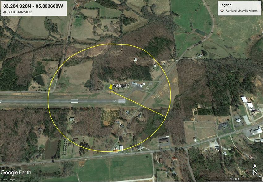
Monitoring Requirements
Appendix A of 40 CFR Part 58 outlines the Quality Assurance Requirements for SLAMS, SPMs,
and PSD Air Monitoring. It details calibration and auditing procedures used to collect valid air
quality data, the minimum number of collocated monitoring sites, calculations used for data quality
assessments, and reporting requirements. All sites operated by ADEM follow the requirements set
forth in Appendix A.
Appendix C of 40 CFR Part 58 specifies the criteria pollutant monitoring methods which must be
used in SLAMS and NCore stations. All criteria pollutant monitoring operated by ADEM follow
the methods specified in Appendix C.
Appendix D of 40 CFR Part 58 specifies network design criteria for ambient air quality
monitoring. The overall design criteria, the minimum number of sites for each parameter, the type
of sites, the spatial scale of the sites, and the monitoring objectives of the sites are detailed. In
designing the air monitoring network for ADEM, the requirements of Appendix D were followed.
The specifics for each pollutant network are in their individual chapters.
Appendix E of 40 CFR Part 58 specifies probe material, placement of the monitoring probe and
spacing from obstructions. All monitors operated by ADEM were evaluated against Appendix E
criteria.
Population and CBSA
Alabama has a 2019 population estimate of 4,903,185. The initial release of the 2020 population
total for Alabama is 5,030,053, but the CSA population totals have not been released yet.
Alabama’s Metropolitan and Micropolitan Core Based Statistical Areas with corresponding
classifications as Metropolitan or Micropolitan, county names included in that area, and the 2019
population totals are listed in Table 2.
Minimum monitoring requirements vary for each pollutant and can be based on a combination of
factors such as population, the level of monitored pollutants, and Core Based Statistical Area
boundaries as defined in the latest U.S. Census information. The term "Core Based Statistical
Area" (CBSA) is a collective term for both Metropolitan Statistical Areas (MSA) and Micropolitan
Statistical Areas (µSA).

                                                 6
Table 2 Alabama CBSAs
2019 Metropolitan or
Alabama Core Based Population Micropolitan
Statistical Area Counties in CBSA Estimate Statistical Areas
Anniston-Oxford Calhoun 113,605 Metropolitan
Auburn-Opelika Lee 164,542 Metropolitan
Bibb, Blount, Chilton, Jefferson,
Birmingham-Hoover Shelby, St. Clair, Walker 1,090,435 Metropolitan
Russell County in Alabama and
Chattahoochee, Harris, Marion,
Columbus, GA-AL Muscogee Counties in Georgia 321,048 Metropolitan
Daphne-Fairhope-Foley Baldwin 223,234 Metropolitan
Decatur Lawrence, Morgan 152,603 Metropolitan
Dothan Geneva, Henry, Houston 149,358 Metropolitan
Florence-Muscle Shoals Colbert, Lauderdale 147,970 Metropolitan
Gadsden Etowah 102,268 Metropolitan
Huntsville Limestone, Madison 471,824 Metropolitan
Mobile Mobile 429,536 Metropolitan
Autauga, Elmore, Lowndes,
Montgomery Montgomery 373,290 Metropolitan
Tuscaloosa Hale, Pickens, Tuscaloosa 252,047 Metropolitan
Albertville Marshall 96,774 Micropolitan
Alexander City Tallapoosa 51,030 Micropolitan
Atmore Escambia 36,633 Micropolitan
Cullman Cullman 83,768 Micropolitan
Enterprise Coffee 52,342 Micropolitan
.Eufaula, AL-GA Micro Area .Eufaula, AL-GA Micro Area 26,985 Micropolitan
Fort Payne DeKalb 71,513 Micropolitan
.Jasper, AL Micro Area .Jasper, AL Micro Area 63,521 Micropolitan
.LaGrange, GA-AL Micro Area .LaGrange, GA-AL Micro Area 103,176 Micropolitan
Ozark Dale 49,172 Micropolitan
Scottsboro Jackson 51,626 Micropolitan
Selma Dallas 37,196 Micropolitan
Talladega-Sylacauga Coosa, Talladega 79,978 Micropolitan
Troy Pike 33,114 Micropolitan
7Figure 1 Alabama MSAs and ADEM Monitoring Sites
8Types of Monitoring Stations
CASTNET – Clean Air Status and Trends Network: is a national air quality monitoring network
designed to provide data to assess trends in air quality, atmospheric deposition, and ecological
effects due to changes in air pollutant emissions. CASTNET provides long-term monitoring of air
quality in rural areas to determine trends in regional atmospheric nitrogen, sulfur, and ozone
concentrations and deposition fluxes of sulfur and nitrogen pollutants in order to evaluate the
effectiveness of national and regional air pollution control programs. EPA-sponsored CASTNET
ozone monitors are Part 58 compliant, therefore the data can be used for regulatory purposes.
CASTNET Ozone data is now reported to AQS. There is one CASNET site in Alabama, Sand
Mountain, AQS ID 01-049-9991, in DeKalb County, operated by an EPA contractor.
NCore – National Core multi-pollutant monitoring station: Sites that measure multiple pollutants
at trace levels in order to provide support to integrated air quality management data needs. Each
state is required to operate at least one NCore site. There is one NCore site in Alabama, North
Birmingham, AQS ID 01-073-0023, located in Jefferson County and operated by JCDH. Refer
to the JCDH Ambient Air Network Plan for details.
PAMS – Photochemical Assessment Monitoring Station: PAMS are established to obtain more
comprehensive data in areas with high levels of ozone pollution by also monitoring oxides of
Nitrogen (NOx) and volatile organic compounds (VOCs). PAMS monitoring requirements were
revised in the 2016 ozone NAAQS rule and a PAMS site will be required in Jefferson County.
Refer to the JCDH Ambient Air Network Plan for details.
SLAMS - State or Local Ambient Monitoring Station: SLAMS make up ambient air quality
monitoring sites that are primarily needed for NAAQS comparisons. ADEM SLAMS monitors
are described in detail in the section labeled ADEM’s Pollutant Network Tables.
SPM – Special Purpose Monitor: Decatur, AQS ID 01-103-0011, began monitoring PM2.5
continuously with an API T-640 on 08/01/2020 and Ward, Sumter Co., AQS ID 01-119-0003,
will begin monitoring NO2 on 01/01/2022 with TBD equipment. Both will be labeled as SPM
while they undergo their 24-month evaluation period, as both of these types of monitors are new
for ADEM.
SO2 DRR - SO2 Data Requirements Rule: DRR became effective September 21, 2015. Per 40
CFR Part 51, states are required to report all sources that generate >2,000 tpy SO2, not dependent
upon population density. Each source in this category must characterize air quality through air
quality modeling or ambient air monitoring. Each source that chooses monitoring must operate
their site equivalent with the SLAMS requirements of 40 CFR Part 58. Alabama has one DRR
SO2 monitoring site, Lhoist, Montevallo Plant, AQS ID 01-117-9001, operated by a Lhoist
contractor within the ADEM PQAO. The Lhoist- Montevallo facility was designated
attainment/unclassifiable on March 26, 2021 under Round IV of the SO2 DRR, based on 2017-
2019 monitoring data. Source-oriented monitoring for SO2 began on January 1, 2017, and
continues to operate in its second 3-yr cycle.
STN – PM2.5 Speciation Trends Network: A PM2.5 speciation station designated to be part of the
speciation trends network. This network provides chemical species data of fine particulates. There
is one STN site in Alabama, North Birmingham, AQS ID 01-073-0023, located in Jefferson
County and operated by JCDH. Refer to the JCDH Ambient Air Network Plan for details.
Supplemental Speciation – A monitoring site that is not dedicated as an STN site in the
Chemical Speciation Network, but has monitors used to gain supplemental data for that network.
ADEM provides supplemental speciation data from Phenix City-South Girard School, AQS ID
01-113-0003.
9ADEM’s Monitoring Networks by Pollutant
Carbon Monoxide (CO) Network
On August 12, 2011, EPA issued a final rule that retained the existing NAAQS for Carbon
Monoxide (CO) and made changes to the ambient air monitoring requirements. EPA revised the
minimum requirements for CO monitoring by requiring CO monitors to be collocated with one
required near-road NO2 monitor in CBSAs having a population of 1,000,000 or more persons.
ADEM does not operate a near-road monitoring site or CO monitor. For more information
regarding CO monitoring in Alabama refer to the JCDH Ambient Air Network Plan for details.
Lead (Pb) Network
In 2008, EPA revised the NAAQS for lead (Pb). The Pb standard was lowered from 1.5 ug/m3 for
a quarterly average to 0.15 ug/m3 based on the highest rolling 3-month average over a 3-year
period. EPA set minimum monitoring requirements for source and population oriented
monitoring. Source oriented monitoring is required near sources that have Pb emissions ≥1 ton
per year. Population oriented monitoring is required for CBSAs >500,000. In December 2010,
EPA revised the Pb rule to require source-oriented monitors for sources greater than ½ ton per year
and stated that population oriented monitors would be located at NCore sites. In March 2016, EPA
removed the requirement for Pb monitoring at NCore sites that were not located near a Pb
emissions source.
Based on current emissions data or modeling, ADEM has identified one source, Sanders Lead
Company, Inc., located in Troy, Pike County, a micropolitan statistical area, which emits greater
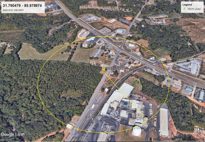
than ½ ton of Pb per year. Troy Lead, AQS ID 01-109-0003, operated by ADEM, has been
monitoring for Pb near that source since 1979. To meet QA requirements, collocated lead
monitoring is also occurring at this site. No additional changes are proposed for this network.
Nitrogen Dioxide (NO2) Network
On January 22, 2010, the US EPA finalized the monitoring rules for Nitrogen Dioxide (NO2). The
rules require the placement of NO2 monitors near a major road in each CBSA with a population
≥500,000 people and a second monitor is required near another major road in areas with either a
CBSA population ≥2.5 million people, or one or more road segments with an annual average daily
traffic (AADT) count ≥250,000 vehicles. For near road NO2 monitoring, Birmingham-Hoover is
the only MSA in Alabama with a population greater than 500,000. However, the population is less
than 2.5 million and there are no road segments with AADT greater than 250,000 vehicles. The
rules also require an NO2 monitor to be placed in any urban area with a population greater than or
equal to 1 million people to assess community-wide concentrations. Birmingham-Hoover is the
only MSA in Alabama with a population greater than 1 million. Refer to the JCDH Ambient Air
Network Plan for details. ADEM plans to begin monitoring NO2 at Ward, Sumter Co., AQS ID
01-119-0003, on January 1, 2022 for the purpose of collecting background data. ADEM will
request an exclusion flag be placed on the data and the monitor be designated SPM while
undergoing its evaluation period.
10Ozone (O3) Network Effective December 28, 2015, the level of the NAAQS for ozone was changed from 0.075 to 0.070 ppm. To attain this standard, the 3-year average of the fourth-highest daily maximum 8-hour average ozone concentrations measured at each monitor within an area over each year must not exceed 0.070 ppm. Minimum monitoring requirements for ozone are based on population and whether the design value is
Ozone Monitoring Requirements for Alabama MSAs
Birmingham-Hoover MSA
Using the Birmingham-Hoover MSA 2019 population estimate and the design value from Table
4, two Ozone monitors are required in this MSA. ADEM operates Helena, AQS ID 01-117-0004,
because it is located in Shelby County. Other ozone sites in this MSA are located within the
jurisdiction of the JCDH. For more information regarding ozone monitoring in Jefferson County
refer to the JCDH ambient air network plan. No changes are planned.

Columbus, GA-AL MSA
Using the Columbus GA-AL MSA 2019 population estimate and the design value from Table 4,
zero Ozone monitors are required for this MSA. ADEM operates Phenix City-South Girard
School, AQS ID 01-113-0003, in Russell County, Alabama. For more information regarding
ozone monitoring in this MSA, refer to the State of Georgia’s ambient air network plan. No
changes are planned.

Daphne-Fairhope-Foley MSA
Using the Daphne-Fairhope-Foley MSA 2019 population estimate and the design value from Table
4, one Ozone monitor is required for this MSA. There is currently one Ozone site, Fairhope,
AQS ID 01-003-0010. No changes are planned.

Decatur MSA
Using the Decatur MSA 2019 population estimate and the design value from Table 4, one Ozone
monitor is required for this MSA. There is currently one Ozone site, Decatur, AQS ID 01-103-
0011. No changes are planned.

Gadsden MSA
Using the Gadsden MSA 2019 population estimate and the design value from Table 4, one Ozone
monitor is required for this MSA. There is currently one Ozone site, Southside, AQS ID 01-055-
0011. No changes are planned.

Huntsville MSA
ADEM does not operate any ozone monitors in this MSA. For information regarding ozone
monitoring in Huntsville refer to the HDNREM ambient air network plan.

Mobile MSA
Using the Mobile MSA 2019 population estimate and the design value from Table 4, two Ozone
monitors are required for this MSA. There are currently two Ozone sites, Chickasaw, AQS ID 01-
097-0003, and Bay Road, 01-097-2005. External factors beyond the control of the ADEM caused
significant data loss at the Bay Road site over the past two years. If the issues persisted into 2021,
the site would need to be moved; however, at this time the site is expected meet completeness for
2021 and no changes are planned.

Montgomery MSA
Using the Montgomery MSA 2019 population estimate and the design value from Table 4, one
Ozone monitor is required for this MSA. There are currently two Ozone sites, MOMS, ADEM,
AQS ID 01-101-1002 and Wetumpka Westside Technology Park, AQS ID 01-051-0004. No
changes are planned.

                                                 12
Tuscaloosa MSA
Using the Tuscaloosa MSA 2019 population estimate and design value from Table 4, zero Ozone
monitors are required for this MSA. There is currently one Ozone site, Duncanville, Tuscaloosa,
AQS ID 01-125-0010. ADEM will move this site to a new ozone monitoring site, located 1.3
miles west of the current location. The new site Duncanville Middle School, AQS ID 01-125-
0011, will begin collecting ozone data before this one is closed.
Anniston-Oxford and Auburn-Opelika MSAs
The MSAs of Auburn-Opelika and Anniston-Oxford were evaluated by ADEM. It was determined
that due to the close proximity of ozone monitors in the neighboring MSAs, additional ozone
monitors would not be needed. Since these areas do not have design values, no ozone monitors are
required by Appendix D of 40 CFR Part 58.
Sites not located in an MSA
Ward, Sumter Co., AQS ID 01-119-0003, represents rural, background ozone values for the
state. The historical design values for this monitor have been less than 85% of the NAAQS. No
changes are planned for ozone monitoring at this site.
Sand Mountain, AQS ID 01-049-9991, is a CASTNET site operated by an EPA contractor.
13PM2.5 Network Minimum monitoring requirements for PM2.5 are based on population and whether the design value is
Table 6 ADEM PM2.5 Monitoring Sites and Design Values
                                                           PM2.5   PM2.5
                                                           24 hr   Annual                         24hr Annual
                                                           DV      DV                             MSA MSA
                                                           2018-   2018-                          MAX MAX        2019
                                                                                                    2     2
     Site Name                                 AQS Site ID 2020    2020   MSA                     DV    DV      Pop Est
                                     1
     Phenix City - South Girard School         01-113-0001   18     9.1   Columbus GA-AL           22    9.1    321,048
     Fairhope                                  01-003-0010   16     7.5   Daphne-Fairhope-Foley    16    7.5    223,234
     Decatur                                   01-103-0011   15     7.3   Decatur                  15    7.3    152,603
     Gadsden C College                         01-055-0010   18     8.0   Gadsden                  18    8.0    102,268
     Chickasaw                                 01-097-0003   17     8.1   Mobile                   17    8.1    429,536
     MOMS, ADEM                                01-101-1002   19     8.4   Montgomery               19    8.4    373,290
     VA, Tuscaloosa                            01-125-0004   16     7.7   Tuscaloosa               16    7.7    252,047
     Ashland (Background/Regional Transport)   01-027-0001   15     7.0   Not in MSA               15    7.0      NA
     Crossville (Background)                   01-049-1003   16     7.2   Not in MSA               16    7.2      NA
     DV ≥ 85% of the NAAQS
     1
15

         Only site within MSA operated by ADEM
     2
         MSA MAX DV may be obtained from monitors not operated by ADEM
PM2.5 Monitoring Requirements for Alabama MSAs
Birmingham-Hoover MSA
ADEM does not operate PM2.5 monitors in the Birmingham-Hoover MSA. For more information
regarding PM2.5 monitoring in this MSA refer to the JCDH ambient air network plan.
Columbus, GA-AL MSA
Using the Columbus, GA-AL MSA 2019 population estimate and the design value from Table 6,
zero FRM monitors are required. ADEM operates one FEM monitor, one collocated FRM monitor,
and one speciation monitor at Phenix City – South Girard School, AQS ID 01-113-0003. The
FEM continuous monitor is the designated primary monitor and the collocated FRM monitor
operates on a 1 in 6 day frequency for quality assurance. For more information regarding other
PM2.5 monitoring in this MSA refer to the State of Georgia’s ambient air network plan.
Daphne-Fairhope-Foley MSA
Using the Daphne-Fairhope-Foley MSA 2019 population estimate and the design value from Table
6, zero FRM monitors are required. There is currently one FRM monitor located at Fairhope,
AQS ID 01-003-0010. No changes are planned.
Decatur MSA
Using the Decatur MSA 2019 population estimate and the design value from Table 6, zero FRM
monitors are required. There is currently one FRM monitor and one FEM continuous monitor
located at Decatur, AQS ID 01-103-0011. The FEM continuous monitor is an API T-640 that
began its 2-year evaluation period on August 1, 2020.
Gadsden MSA
Using the Gadsden MSA 2019 population estimate and the design value from Table 6, zero FRM
monitors are required. There is currently one FRM monitor at Gadsden Community College,
AQS ID 01-055-0010. No changes are planned.
Huntsville MSA
ADEM does not operate PM2.5 monitors in the Huntsville MSA. For information regarding PM2.5
monitoring in this MSA refer to the HDNREM ambient air network plan.
Mobile MSA
Using the Mobile MSA 2019 population estimate and the design value from Table 6, zero FRM
monitors are required. There is currently one FRM monitor and one non-FEM continuous monitor
located at Chickasaw, AQS ID 01-097-0003. Both the non-FEM continuous BAM 1020 and the
FRM monitors will be replaced by one continuous FEM BAM 1022 PM2.5 monitor effective
January 1, 2022. This is just a change of equipment, PM will continue to be monitored at this site.
Montgomery MSA
Using the Montgomery MSA 2019 population estimate and the design value from Table 6, zero
FRM monitors are required. There is currently one FRM monitor, one collocated FRM monitor,
and one non-FEM continuous monitor located at MOMS, ADEM, AQS ID 01-101-1002. No
changes are planned.
16Tuscaloosa MSA
Using the Tuscaloosa MSA 2019 population estimate and the design value from Table 6, zero
FRM monitors are required. There is currently one FRM monitor and one collocated FRM monitor
located at VA, Tuscaloosa, AQS ID 01-125-0004. No changes are planned.
Anniston-Oxford and Auburn-Opelika MSAs
The MSAs of Anniston-Oxford and Auburn-Opelika were evaluated to determine the need for
monitors. It was determined that due to the close proximity of PM2.5 monitors in neighboring
MSAs, additional monitors would not be needed. PM2.5 monitoring in the adjacent MSAs continue
to provide adequate coverage. Since these areas do not have design values, no FRM monitors are
required by Appendix D of 40 CFR Part 58.
PM2.5 Monitors not located in MSAs
Ashland, AQS ID 01-027-0001, serves as a regional transport site in between the large MSAs of
Birmingham-Hoover, Alabama and Atlanta-Sandy Springs-Roswell, Georgia using one FRM
monitor. No changes are planned.
Crossville, AQS ID 01-049-1003, represents rural, background PM2.5 values for the northeast part
of the state using one FRM monitor. No changes are planned.
Ward, Sumter Co., AQS ID 01-119-0003, represents rural, background PM2.5 values for the west
part of the state using one continuous FEM BAM-1022. No changes are planned.
17PM10 Network
PM10 has been a criteria pollutant since 1987. Since that time there has been widespread
monitoring of the PM10 levels in Alabama. In 2006, the U.S. EPA modified the NAAQS for PM10
to revoke the annual standard. Currently, there is a daily standard of 150 ug/m3 based on 3 years
of data.
The Montgomery MSA has a population between 250,000 and 500,000 and PM10 concentrations
are less than 80% of the NAAQS daily standard. According to Table D-4 of Appendix D to Part
58, 0 to 1 PM10 monitors are required. In the Montgomery MSA, ADEM operates two low-volume
PM10 monitors on a 1 in 6 day schedule at MOMS, ADEM, AQS ID 01-101-1002, one being the
collocated quality assurance monitor. No changes are planned.
Sulfur Dioxide (SO2) Network
Effective August 23, 2010, EPA strengthened the primary NAAQS for SO2. EPA established a
new 1-hour standard at 75 ppb, based on the 3-year average of the annual 99th percentile of 1-hour
daily maximum concentrations. According to EPA, for a short-term 1-hour SO2 standard, it is
more technically appropriate, efficient, and effective to use modeling as the principal means of
assessing compliance for medium to larger sources, and to rely more on monitoring for groups of
smaller sources and sources not as conducive to modeling. Such an approach is consistent with
EPA’s historical approach and longstanding guidance for SO2. EPA is setting specific minimum
requirements that inform states on where they are required to place SO2 monitors. The final
monitoring regulations require monitors to be placed in Core Based Statistical Areas (CBSAs)
based on a Population Weighted Emissions Index (PWEI) for the area. The final rule requires:
3 monitors in CBSAs with PWEI values ≥1,000,000 or more;
2 monitors in CBSAs with PWEI values 100,000; and
1 monitor in CBSAs with PWEI values >5,000.
According to the latest PWEI calculations listed in
Table 7 only the Birmingham-Hoover MSA requires SO2 monitoring. ADEM operates two SO2
monitors: Chickasaw, AQS ID 01-097-0003, for the Mobile MSA and Ward, Sumter Co., AQS
ID 01-119-0003, not located in an MSA, for background purposes. For more information regarding
SO2 monitoring in the Birmingham-Hoover MSA refer to the JCDH ambient air monitoring
network plan.
Effective September 21, 2015, the SO2 Data Requirements Rule (DRR) per 40 CFR Part 51,
requires states to report all sources that generate >2,000 tpy SO2, not dependent upon population
density. Each source in this category must characterize air quality through air quality modeling or
ambient air monitoring. Each source that chooses monitoring must operate their site equivalent
with the SLAMS requirements of 40 CFR Part 58. Lhoist North America of Alabama, LLC –
Montevallo Plant, located within the Birmingham-Hoover MSA, has monitored SO2 in accordance
with the DRR since January 1, 2017. The site is Lhoist, Montevallo Plant, AQS ID 01-117-9001,
and operates within ADEM’s PQAO.
18Table 7 SO2 Minimum Monitoring Site Requirements
SO2 Population Weighted Emissions Index (PWEI) Calcuations using 2019 Census
Estimates and 2017 National Emissions Inventory (NEI) v2
PWEI in
2017 NEI v2 Population Million Required
CBSA Name SO2 (tpy) (2019) persons-tpy Monitors
Birmingham-Hoover 19,971 1,090,435 21,777 2
Mobile 7,948 429,536 3,414 0
Florence-Muscle
160 147,970 24 0
Shoals
Albertville 33 96,774 3 0
Anniston-Oxford-
141 113,605 16 0
Jacksonville
Auburn-Opelika 155 164,542 26 0
Columbus, GA-AL 3,571 321,048 1,146 0
Cullman 62 83,768 5 0
Daphne-Fairhope-
167 223,234 37 0
Foley
Decatur 1,834 152,603 280 0
Dothan 201 149,358 30 0
Enterprise 87 52,342 5 0
Gadsden 39 102,268 4 0
Huntsville 173 471,824 82 0
Montgomery 2,415 373,290 901 0
Ozark 125 63,521 8 0
Scottsboro 721 51,626 37 0
Selma 125 37,196 5 0
Talladega-Sylacauga 226 79,978 18 0
Troy 8,141 33,114 270 0
Tuscaloosa 474 252,047 119 0
Valley 88 no data 0 0
Quality Assurance
ADEM has an EPA-approved Quality Assurance Program Plan (QAPP) that details the activities
used to control and document the quality of the data collected. ADEM is an independent Primary
Quality Assurance Organization (PQAO) as defined by 40 CFR Part 58. Part of the EPA-required
quality control program for particulate monitoring is the use of collocated particulate monitors. 40
CFR Part 58, Appendix A requires a percentage of manual particulate monitors to be collocated
with FRM monitors so that quality statistics can be calculated. ADEM includes monitors for this
purpose.
19ADEM AAQMP Pollutant Network Tables
A description of ADEM’s ambient air monitoring network, followed by detailed site evaluations,
will be presented in this section.
Included will be:
Site Common Name
County/CBSA
AQS ID
Address
Latitude and Longitude
Monitoring Objective/Scale
Beginning and Ending Sampling Date
Method, Method Code and Operating Schedule
Comparability to the NAAQS
20Lead
Site Method, Method
NAAQS
Common Monitoring Objective / Date Date Code and
Name County/CBSA AQS ID Address Latitude Longitude Scale Began Ended Schedule
Henderson Road, Highest Concentration / 1/1/1979 active Hi-Vol 813, 6 Y
Troy Lead Pike/Troy µSA 01-109-0003 Troy 31.790479 -85.978974 Neighborhood 1/1/1979 active Hi-Vol 813, 6 Y
Hi-Vol = Hi-Volume Total Suspended Particulate G = Lead Analysis by Graphite Furnace 6 = 24 hours every 6th day
Ozone
Site Method, Method
NAAQS
Common Monitoring Objective / Date Date Code and
Name County/CBSA AQS ID Address Latitude Longitude Scale Began Ended Schedule
Baldwin/Daphne- Fairhope High Population Exposure/
Fairhope Fairhope-Foley MSA 01-003-0010 School, Fairhope 30.497478 -87.880258 Neighborhood 3/1/2000 active U, 087, C Y
Wetumpka
Westside
Technology Elmore/Montgomery 3148 Elmore Road, Highest Concentration/
Park MSA 01-051-0004 Wetumpka 32.53568 -86.255193 Urban 3/1/2018 active U, 087, C Y
1450 Parker
Anderson Lane, Highest Concentration/
21
Southside Etowah/Gadsden MSA 01-055-0011 Southside 33.904039 -86.053867 Neighborhood 4/26/2002 active U, 087, C Y
Iroquois and Azalea Population Exposure/
Chickasaw Mobile/Mobile MSA 01-097-0003 Chickasaw 30.770181 -88.087761 Neighborhood 3/2/1982 active U, 087, C Y
Population Exposure and
Bay Road Mobile/Mobile MSA 01-097-2005 Bay Road, Mobile 30.474305 -88.141022 Highest Concentration/ 3/1/1999 active U, 087, C Y
MOMS, Montgomery/Montgome 1350 Coliseum Blvd, Population Exposure/
ADEM ry MSA 01-101-1002 Montgomery 32.412811 -86.263394 Neighborhood 6/2/1993 active U, 087, C Y
Wallace
Development Center, Population Exposure/
Decatur Morgan/Decatur MSA 01-103-0011 Decatur 34.530717 -86.967536 Urban 4/1/2000 active U, 087, C Y
Phenix City - Russell/Columbus GA- 510 6th Place South, Highest Concentration/
South Girard AL MSA 01-113-0003 Phenix City 32.437028 -84.999653 Urban 3/1/2018 active U, 087, C Y
Shelby/Birmingham- Bearden Farm. Population Exposure/
Helena Hoover MSA 01-117-0004 Helena 33.317142 -86.825754 Urban 1/1/1983 active U, 087, C Y
Ward, NNE of Ward Post General/Background/
Sumter Co. Sumter/no MSA 01-119-0003 Office 32.362606 -88.277992 Regional 3/1/2013 active U, 087, C Y
Duncanville, Tuscaloosa/Tuscaloosa 11690 Southfork Population Exposure/
Tuscaloosa MSA 01-125-0010 Drive, Duncanville 33.089772 -87.459733 Urban 2/1/2001 active U, 087, C Y
U = UV Photometric Ozone Analyzer C = ContinuousPM2.5
Site Method, Method
NAAQS
Common Monitoring Date Date Code and
Name County/CBSA AQS ID Address Latitude Longitude Objective/Scale Began Ended Schedule
Baldwin/ Daphne- Fairhope High Population Exposure/
Fairhope Fairhope-Foley MSA 01-003-0010 School, Fairhope 30.497478 -87.880258 Neighborhood 1/1/2000 active L, 145, 3 Y
Ashland Airport, Regional Transport/
Ashland Clay/no MSA 01-027-0001 Ashland 33.284928 -85.803608 Regional 1/1/1999 active L, 145, 3 Y
13112 Hwy 68, General/Background/
Crossville DeKalb/no MSA 01-049-1003 Crossville 34.288567 -85.969858 Neighborhood 1/1/1999 active L, 145, 3 Y
Gadsden C 1001 Wallace Drive, Population Exposure/
College Etowah/Gadsden MSA 01-055-0010 Gadsden 33.991494 -85.992647 Urban 1/1/2000 active L, 145, 3 Y
Iroquois and Azalea, Population Exposure/ 7/19/2002 active L, 145, 3 Y
Chickasaw Mobile/Mobile MSA 01-097-0003 Chickasaw 30.770181 -88.087761 Regional 1/1/2011 active B, 731, C N
1/16/2009 active L, 145, 3 Y
MOMS, Montgomery/ 1350 Coliseum Blvd, Population Exposure/ 1/16/2009 active L, 145, 6 Y
ADEM Montgomery MSA 01-101-0002 Montgomery 32.412811 -86.263394 Neighborhood 4/1/2009 active B, 731, C N
Wallace Ctr.Hwy 31, Population Exposure/ 8/7/2001 active L, 145, 3 Y
1
Decatur Morgan/Decatur MSA 01-103-0011 Decatur 34.530717 -86.967536 Middle 8/1/2020 active T, 236, C N
Phenix City - Russell/Columbus GA- 510 6th Place South, Highest Concentration/ 9/18/2017 active B, 209, C Y
22
S. Girard AL MSA 01-113-0003 Phenix City 32.437028 -84.999653 Urban 1/18/2017 active L, 145, 6 Y
Ward, NNE of Ward Post General/Background/
Sumter Co. Sumter/no MSA 01-119-0003 Office, Ward 32.362606 -88.277992 Regional 1/1/2021 active B, 209, C Y
VA, Tuscaloosa/Tuscaloosa 3701 Loop Road East, Population Exposure/ 10/1/2002 active L, 145, 3 Y
Tuscaloosa MSA 01-125-0004 Tuscaloosa 33.189931 -87.484189 Neighborhood 1/1/2021 active L, 145, 6 Y
B = Beta Attenuation Monitor L = Low Volume Sequential Sampler T = T640 3 = 24 hours every 3rd day 6 = 24 hours every 6th day C = Continuous
1
Decatur - Began 2-year evaluation period on the T640 continuous monitor.
PM10
Site Method, Method
NAAQS
Common Monitoring Objective / Date Date Code and
Name County / CBSA AQS ID Address Latitude Longitude Scale Began Ended Schedule
Population Exposure/
Neighborhood 9/16/1993 active L, 127, 6 Y
MOMS, Montgomery / 1350 Coliseum Blvd, Quality Assurance/
ADEM Montgomery MSA 01-101-1002 Montgomery 32.412811 -86.263394 Neighborhood 1/1/2013 active L, 127, 6 Y
L = Low Volume Sequential Sampler 6 = 24 hours every 6th daySO2
Site Method, Method
NAAQS
Common Monitoring Objective / Date Date Code and
Name County / CBSA AQS ID Address Latitude Longitude Scale Began Ended Schedule
Iroquois And Azalea, Population Exposure /
Chickasaw Mobile / Mobile MSA 01-097-0003 Chickasaw 30.76972 -88.0875 Neighborhood 1/1/2013 active P, 100, C Y
Shelby / Birmingham- 7444 St. Hwy 25, High Concentration –
Lhoist Hoover MSA 01-117-9001 Calera 33.0928 -86.8072 SO2 DRR / Middle 1/1/2017 active P, 100, C Y
NNE of Ward Post General/Background /
Ward Sumter / no MSA 01-119-0003 Office, Ward 32.362606 -88.277992 Regional 1/1/2018 active P, 100, C Y
P = Pulsed Fluorescent C = Continuous
NO2*
Site Proposed Method, Method
NAAQS
Common Monitoring Objective / Beginning Date Code and
Name County / CBSA AQS ID Address Latitude Longitude Scale Date Ended Schedule
NNE of Ward Post General/Background /
Ward Sumter / no MSA 01-119-0003 Office, Ward 32.362606 -88.277992 Regional 1/1/2022 CAP, 212, C N
CAP = Cavity Attenuated Phase Shift C = Continuous
23
*Method listed is proposed dependent on procurement of equipmentAppendix A
Site Assessments
All of ADEM’s sites meet the requirements of 40 CFR 58, Appendices A, C, D and E, as
appropriate. The following issues were observed during site evaluations and any corrective
actions noted.
Site Issue Correction
Chickasaw Tree dripline was less than 10m All tree foliage west of the PM
AQS ID 01-097-0003 west of the PM 2.5 FRM Inlet 2.5 FRM Inlet Head was
Head removed.
Gadsden C College Volunteer shrub was less than 10m The shrub was removed.
AQS ID 01-055-0010 north of the PM 2.5 FRM Inlet
Head
Helena Tree dripline was less than 10m The tree was removed.
AQS ID 01-117-004 northwest of the Ozone Inlet
24ASHLAND AQS ID 01-027-0001
Ashland Airport, Ashland, Clay County 33.284928, -85.803608
MSA: N/A 420m from Hwy 9 AADT 6180 (2017) Property Type: Residential (private)
NORTH SOUTH EAST WEST
Parameter Monitoring Schedule Start Date AQS Probe/Rain Probe Distance Distance Height of
Objective/ Method Shield Inlet from from nearest tree/
Scale Code Material Height probe to probe to Direction
from supporting nearest from probe to
ground structure tree tree
dripline
PM 2.5 Regional Every 3 01/01/1999 145 Inlet Head 2.0 m N/A 33.8m 11.2m East
Transport/ days
Regional
This site meets all requirements of 40 CFR Part 58. Evaluation Date: 03/12/2021
25BAY ROAD AQS ID 01-097-2005
Bay Road, Theodore, Mobile County 30.474305, -88.141022
MSA: Mobile 68.5 m to Bay Road Property Type: Agricultural (county)
NORTH SOUTH EAST WEST
Parameter Monitoring Schedule Start Date AQS Probe/Rain Probe Distance Distance Height of
Objective/ Method Shield Inlet from from nearest tree/
Scale Code Material Height probe to probe to Direction
from supporting nearest from probe to
ground structure tree tree
dripline
Ozone Population Continuous 03/01/1999 087 Teflon 4.4m 1.2m 31.0m 14.4m South
Exposure and
Highest
Concentration/
Urban
This site meets all requirements of 40 CFR Part 58. Evaluation Date: 03/19/2021
26CHICKASAW AQS ID 01-097-0003
801 Iroquois St., Chickasaw, Mobile County 30.770181, -88.087761
MSA: Mobile 56.8 m from Iroquois St Property Type: Commercial (city)
NORTH SOUTH EAST WEST
Parameter Monitoring Schedule Start Date AQS Probe/Rain Probe Distance Distance Height of
Objective/ Method Shield Inlet from from nearest tree/
Scale Code Material Height probe to probe to Direction
from supporting nearest from probe
ground structure tree to tree
dripline
Ozone Population Continuous 03/02/1982 087 Teflon/ 4.3m 1.2m 12.0m 4.8m
Exposure/ Teflon Southwest
SO2 Neighborhood 01/01/2013 100 Teflon/ 4.8m 1.7m 15.7m
Teflon
BAM 2.5 Population Continuous 01/01/2015 731 Inlet Head 5.2m 2.1m 14.6m
PM 2.5 Exposure/ Once every 07/19/2002 145 Inlet Head 2.1m N/A 8.1m
Regional 3 days
All tree foliage west of the shelter was removed within 14 days of this evaluation. Evaluation Date: 03/19/2021
27CROSSVILLE AQS ID 01-049-1003
13112 Highway 68, Crossville, DeKalb County 34.288567, -85.969858
USA: Fort Payne 172.2 m from Hwy 68 AADT 5980 (2017) Property Type: Agricultural (Auburn University)
NORTH SOUTH EAST WEST
Parameter Monitoring Schedule Start Date AQS Probe/Rain Probe Distance Distance Height of
Objective/ Method Shield Inlet from from nearest tree/
Scale Code Material Height probe to probe to Direction
from supporting nearest from probe to
ground structure tree tree
dripline
PM 2.5 General Every 3 10/01/2002 145 Inlet Head 2.0 m N/A 23.1 m 8.4 m East
Background/ days
Neighborhood
This site meets all requirements of 40 CFR Part 58. Evaluation Date: 03/31/2021
28DECATUR AQS ID 01-103-0011
JH Crow Drive, Decatur, Morgan County 34.530717, -86.967536
MSA: Decatur 525.9 m from Hwy 31 AADT 16,650 (2017) Property Type: Commercial (Armory Comm. of Alabama)
NORTH SOUTH EAST WEST
Parameter Monitoring Schedule Start Date AQS Probe/Rain Probe Distance Distance Height of
Objective/ Scale Method Shield Inlet from from nearest
Code Material Height probe to probe to tree/
from supporting nearest Direction
ground structure tree from
dripline probe to
tree
Ozone Population Continuous 04/01/2000 047 Teflon/ 4.3 m 1.7 m 21.7m 11.8 m
Exposure/Urban Teflon Southwest
T640 2.5 Population Continuous 08/01/2020 236 Inlet Head 4.7 m 2.1 m 24.1m
PM 2.5 Exposure/Middle Every 3 08/07/2001 145 Inlet Head 4.6 m 2.1 m 23.2 m
days
This site meets all requirements of 40 CFR Part 58. Evaluation Date: 04/01/2021
29FAIRHOPE AQS ID 01-003-0010
1 Pirate Drive, Fairhope, Baldwin County 30.497478, -87.880258
MSA: Daphne-Fairhope-Foley 438.0 m from Pirate Drive Property Type: Commercial (county)
NORTH SOUTH EAST WEST
Parameter Monitoring Schedule Start Date AQS Probe/Rain Probe Distance Distance Height of
Objective/ Method Shield Inlet from from nearest
Scale Code Material Height probe to probe to tree/
from supporting nearest Direction
ground structure tree from probe
dripline to tree
Ozone Population Continuous 03/01/2000 087 Teflon 4.4 m 1.8 m 24.9 m 6.8 m East
PM 2.5 Exposure/ Every 3 01/01/2000 145 Inlet Head 2.0 m N/A 21.9 m
Neighborhood days
This site meets all requirements of 40 CFR Part 58. Evaluation Date: 03/19/2021
30GADSDEN C COLLEGE AQS ID 01-055-0010
1001 George Wallace Drive, Gadsden, Etowah County 33.991494, -85.992647
MSA: Gadsden 445m from George Wallace Dr. 21,120 AADT (2017) Property Type: Commercial (college)
NORTH SOUTH EAST WEST
Parameter Monitoring Schedule Start Date AQS Probe/Rain Probe Distance Distance Height of
Objective/ Method Shield Inlet from from nearest tree/
Scale Code Material Height probe to probe to Direction from
from supporting nearest probe to tree
ground structure tree
dripline
PM 2.5 Population Every 3 10/01/2002 145 Inlet Head 2.0 m N/A 18.2m 6.6 m North
Exposure/ days
Urban
This site meets all requirements of 40 CFR Part 58. Evaluation Date: 03/31/2021
31HELENA AQS ID 01-117-0004
237 Limestone Drive, Helena, Shelby County 33.317142, -86.825754
MSA: Birmingham-Hoover 30.4 m to Limestone Drive Property Type: Agricultural (private)
NORTH SOUTH EAST WEST
Parameter Monitoring Schedule Start Date AQS Probe/Rain Probe Distance Distance Height of
Objective/ Method Shield Inlet from from nearest tree/
Scale Code Material Height probe to probe to Direction
from supporting nearest from probe
ground structure tree to tree
dripline
Ozone Population Continuous 01/01/1983 087 Teflon/ 4.4 m 1.6 m 9.1 m 4.8 m
Exposure/ Teflon See Field Northwest
Notes
Urban
This site meets all requirements of 40 CFR Part 58. Evaluation Date: 03/31/2021
32LHOIST, MONTEVALLO PLANT AQS ID 01-017-9001
7444 Highway 25, Calera, Shelby County 33.0928, -86.8072
MSA: Birmingham-Hoover 22m from Hwy 25 AADT 8270 (2017) Property Type: Industrial (private)
NORTH SOUTH EAST WEST
Parameter Monitoring Schedule Start Date AQS Probe/Rain Probe Distance Distance Height of
Objective/ Method Shield Inlet from from nearest tree/
Scale Code Material Height probe to probe to Direction
from supporting nearest from probe
ground structure tree to tree
dripline
SO2 Highest Continuous 01/01/2017 100 Teflon 3.5 m 1.5 m 17.6m 3.9 m
Concentration/ Southwest
Middle
This site meets all requirements of 40 CFR Part 58. Evaluation Date: 04/08/2021
33MOMS, ADEM AQS ID 01-101-1002
1350 Coliseum Boulevard, Montgomery, Montgomery County 32.412811, -86.263394
MSA: Montgomery 290.8 m to Coliseum Boulevard Property Type: Commercial (state)
NORTH SOUTH EAST WEST
Parameter Monitoring Start Date AQS Probe/Rain Probe Distance Distance Distance Height
Objective/ Method Shield Inlet from between from of
Scale Code Material Height probe to collocated probe to nearest
from supporting samplers nearest tree/
Direction
ground structure tree from
dripline probe to
tree
Ozone - continuous Population 06/02/1993 087 Teflon/ 4.6 m 1.9 m N/A 63.3 m 9.8 m
Exposure/ Teflon 64.5 m West
BAM 2.5 - continuous Neighborhood 01/01/2015 731 Inlet Head 5.1 m 2.4 m 65.8 m
PM 2.5 – 1 in 3 days 01/16/2009 145 4.8 m N/A 1.9 m 68.0 m
PM 2.5 Co – 1 in 6 days 57.0 m
PM 10 – 1 in 6 days 09/16/1993 127 3.3 m 1.3 m 58.6 m
PM 10 Co – 1 in 6 days QA/ 01/01/2013
Neighborhood
This site meets all requirements of 40 CFR Part 58. Evaluation Date: 04/05/2021
34You can also read