APPENDIX E UPDATED TRAFFIC IMPACT ASSESSMENT (TIA) - Amendment Report Wellington North Solar Farm
←
→
Page content transcription
If your browser does not render page correctly, please read the page content below
Amendment Report
                                    Wellington North Solar Farm

APPENDIX E UPDATED TRAFFIC IMPACT
           ASSESSMENT (TIA)

NGH Pty Ltd | 20-483 - Final V1.1                          | E-I
Lightsource bp
Wellington North Solar Project Development
                 Traffic Impact Assessment

                                  October 2020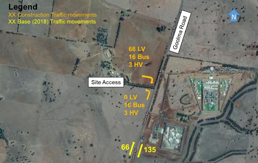
Disclaimer
    This report: has been prepared by GHD for Lightsource bp and may only be used and relied on by
    Lightsource bp for the purpose agreed between GHD and the Lightsource bp.

    GHD otherwise disclaims responsibility to any person other than Lightsource bp arising in connection with
    this report. GHD also excludes implied warranties and conditions, to the extent legally permissible.

    The services undertaken by GHD in connection with preparing this report were limited to those specifically
    detailed in the report and are subject to the scope limitations set out in the report.

    The opinions, conclusions and any recommendations in this report are based on conditions encountered
    and information reviewed at the date of preparation of the report. GHD has no responsibility or obligation
    to update this report to account for events or changes occurring subsequent to the date that the report was
    prepared.

    The opinions, conclusions and any recommendations in this report are based on assumptions made by
    GHD described in this report. GHD disclaims liability arising from any of the assumptions being incorrect.

    GHD has prepared this report on the basis of information provided by Lightsource bp and others who
    provided information to GHD (including Government authorities), which GHD has not independently
    verified or checked beyond the agreed scope of work. GHD does not accept liability in connection with
    such unverified information, including errors and omissions in the report which were caused by errors or
    omissions in that information.

                             GHD | Report for Lightsource bp - Wellington North Solar Project Development, 12538291 | i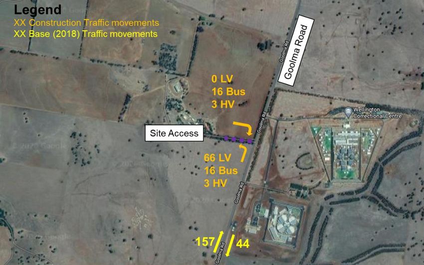
Table of contents
  1.   Introduction .................................................................................................................................... 1
       1.1      Overview .............................................................................................................................. 1
       1.2      Study area............................................................................................................................ 1
       1.3      Study assumptions and limitations ...................................................................................... 3
       1.4      Report structure ................................................................................................................... 3
  2.   Existing conditions ......................................................................................................................... 4
       2.1      The site ................................................................................................................................ 4
       2.2      Existing road network characteristics .................................................................................. 5
       2.3      Existing road network performance ................................................................................... 12
       2.4      Crash data review .............................................................................................................. 17
       2.5      Public and active transport ................................................................................................ 18
  3.   Traffic impact assessment ........................................................................................................... 20
       3.1      Wellington North Solar Farm life cycle overview ............................................................... 20
       3.2      Construction traffic generation ........................................................................................... 21
       3.3      Mid-block assessment ....................................................................................................... 23
       3.4      Intersection treatment ........................................................................................................ 23
       3.5      Oversize vehicles ............................................................................................................... 25
       3.6      Cumulative construction traffic impacts ............................................................................. 26
       3.7      Operational phase traffic movements ................................................................................ 29
       3.8      Decommissioning phase traffic movements ...................................................................... 30
  4.   Parking provision.......................................................................................................................... 31
       4.1      Parking provision ............................................................................................................... 31
       4.2      Parking layout .................................................................................................................... 31
  5.   Mitigation measures ..................................................................................................................... 32
       5.1      Construction activity traffic management ........................................................................... 32
       5.2      Road improvements ........................................................................................................... 33
  6.   Summary and recommendations ................................................................................................. 34
       6.1      Traffic impact ..................................................................................................................... 34
       6.2      Parking ............................................................................................................................... 34
       6.3      Mitigation measures ........................................................................................................... 34
       6.4      Conclusion ......................................................................................................................... 35

                                        GHD | Report for Lightsource bp - Wellington North Solar Project Development, 12538291 | ii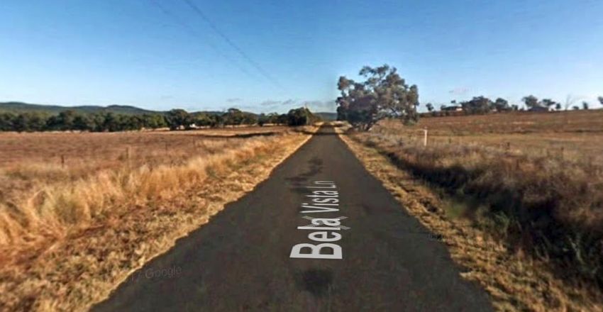
Table index
  Table 2-1 Cobbora Road key features ..................................................................................................... 7
  Table 2-2 Goolma Road key features ...................................................................................................... 8

  Table 2-3 Campbells Lane key features .................................................................................................. 9
  Table 2-4 Bela Vista Lane key features ................................................................................................. 10
  Table 2-5 Mitchell Highway key features ............................................................................................... 11

  Table 2-6 Peak hour average surveyed traffic volume on Cobbora Road ............................................. 14
  Table 2-7 Key traffic data summary on Cobbora Road .......................................................................... 14
  Table 2-8 Peak hour average surveyed traffic volume on Goolma Road .............................................. 15

  Table 2-9 Key traffic data summary on Goolma Road ........................................................................... 15
  Table 2-10 Peak hour average surveyed traffic volume on Campbells Lane ........................................ 17
  Table 2-11 Key traffic data summary on Campbells Lane ..................................................................... 17
  Table 2-12 Crash summary .................................................................................................................... 18
  Table 3-1 Peak daily trip generation (two-way) ...................................................................................... 21
  Table 3-2 Mid-block level of service (peak flows per direction) ............................................................. 23
  Table 3-3 Peak hour mid-block level of service ..................................................................................... 23
  Table 3-4 Goolma Road cumulative peak hour mid-block level of service ............................................ 29

Figure index
  Figure 1-1 Site location ............................................................................................................................ 2
  Figure 1-2 Road network near the subject site ........................................................................................ 2
  Figure 2-1 Land zoning ............................................................................................................................ 4
  Figure 2-2 Surrounding road network ...................................................................................................... 6
  Figure 2-3 Cobbora Road, west of the site (looking south) ...................................................................... 7
  Figure 2-4 Goolma Road, east of the site (looking south) ....................................................................... 8
  Figure 2-5 Campbells Lane, north of the site (looking west) .................................................................... 9
  Figure 2-6 Bela Vista Lane, north of the site (looking west) .................................................................. 10
  Figure 2-7 Mitchell Highway, west of the site (looking west) ................................................................. 11
  Figure 2-8 Traffic survey locations ......................................................................................................... 12
  Figure 2-9        Daily traffic volumes on Cobbora Road ............................................................................. 13

  Figure 2-10 Weekday and seven day average hourly traffic profile on Cobbora Road (two-
              way) ................................................................................................................................... 13
  Figure 2-11 Daily traffic volumes on Goolma Road ............................................................................... 14

                                           GHD | Report for Lightsource bp - Wellington North Solar Project Development, 12538291 | iii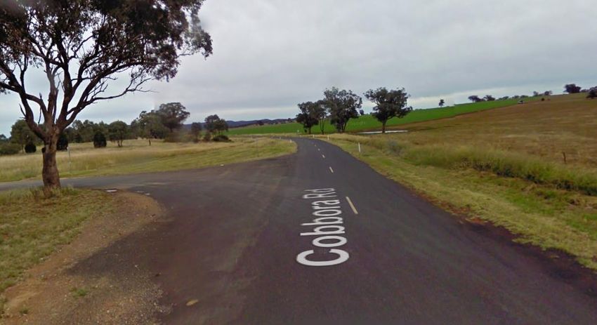
Figure 2-12 Weekday and seven day average hourly traffic profile on Goolma Road (two-
            way) ................................................................................................................................... 15
Figure 2-13 Daily traffic volumes on Campbells Lane............................................................................ 16
Figure 2-14 Weekday and seven day average hourly traffic profile on Campbells Lane (two-
            way) ................................................................................................................................... 16
Figure 2-15 Study area crash data ......................................................................................................... 17

Figure 2-16 Wellington Town Centre bus route ..................................................................................... 18
Figure 2-17 School bus routes ............................................................................................................... 19
Figure 3-1 AM peak hour construction vehicle movements ................................................................... 22

Figure 3-2 PM peak hour construction vehicle movements ................................................................... 22
Figure 3-3 Intersection left turn treatment review................................................................................... 24
Figure 3-4 AUL(S)/BAL turn treatments ................................................................................................. 25

Figure 3-5 Oversized vehicle example ................................................................................................... 26
Figure 3-6 Existing and future facilities within proximity of Wellington North Solar Farm ...................... 27

                                        GHD | Report for Lightsource bp - Wellington North Solar Project Development, 12538291 | iv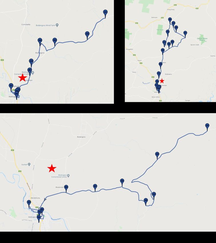
1. Introduction
1.1 Overview
GHD has been engaged by NGH Pty Ltd to undertake a review of the traffic impact assessment
to assist with the construction and operation of the proposed Wellington North Solar Farm
(WNSF).
The Wellington North Solar Farm (Project) in central-western NSW is currently being developed
by Lightsource bp. The project is located approximately seven kilometres northeast of
Wellington town centre, off Goolma Road, in the Dubbo Regional Council Local Government
Area.
This Traffic and Parking Impact assessment report discusses the following:
Existing Conditions – a review of existing road features and access, adjacent
developments, traffic volumes and crash data;
Proposed Development – a review of additional traffic generated as a result of the
proposed solar plan during construction and operation;
Development Impact – assessment of the performance of the existing intersections
resulting from the proposed solar farm development; and
Parking and Access Review – a review of the parking provision in relation to relevant
local development requirements or future construction / operational activity, and a
summary of the transportation routes for access and egress arrangements.
1.2 Study area
1.2.1 Site location
The subject site is located within the Dubbo Regional Council Local Government Area (LGA),
seven kilometres northeast of Wellington town centre between Cobbora Road and Goolma
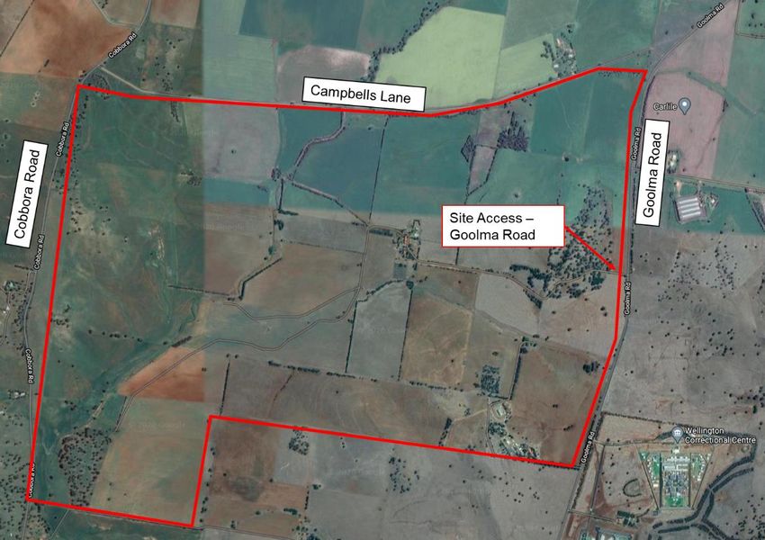
Road. The site shown in Figure 1-1 is located to the west of Goolma Road and consists of
approximately 970 hectares of land that is currently used for agricultural purposes.
The vehicular access point to the development site is proposed to utilise the existing driveway
off Goolma Road that currently leads to the residential dwelling on the property. This report will
review the suitability of this access and outline potential upgrades that may be required
The location of the proposed WNSF in relation to the surrounding road network is shown in
Figure 1-2.
GHD | Report for Lightsource bp - Wellington North Solar Project Development, 12538291 | 1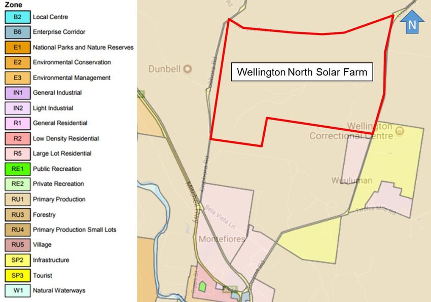
Figure 1-1 Site location

Source: Google Maps – Modified by GHD

Figure 1-2 Road network near the subject site

Source: Google Maps – Modified by GHD

                        GHD | Report for Lightsource bp - Wellington North Solar Project Development, 12538291 | 2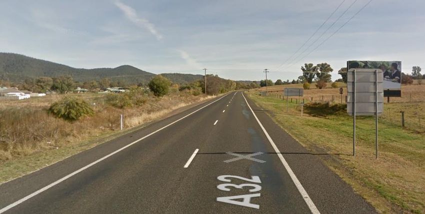
1.3 Study assumptions and limitations
This report and assessment for the proposed WNSF are based on the following assumptions
and limitations:
The information provided by NGH and Lightsource bp in relation to expected truck and
vehicle generation and arrival-departure locations for the construction and staff personnel
is accurate.
The traffic count survey data based on automatic tube count conducted between 28
February 2018 and 6 March 2018 by Matrix Traffic and Data Solutions is accurate.
The analysis is a desktop study and no site visits have been undertaken.
The conditions of the surrounding road network are based on information either supplied
by the traffic surveys and Google Maps / Streetview.
1.4 Report structure
The report is structured as follows:
Section 2 Existing conditions.
Section 3 Traffic impact and assessment.
Section 4 Parking provision.
Section 5 Mitigation measures.
Section 6 Summary and recommendations.
GHD | Report for Lightsource bp - Wellington North Solar Project Development, 12538291 | 3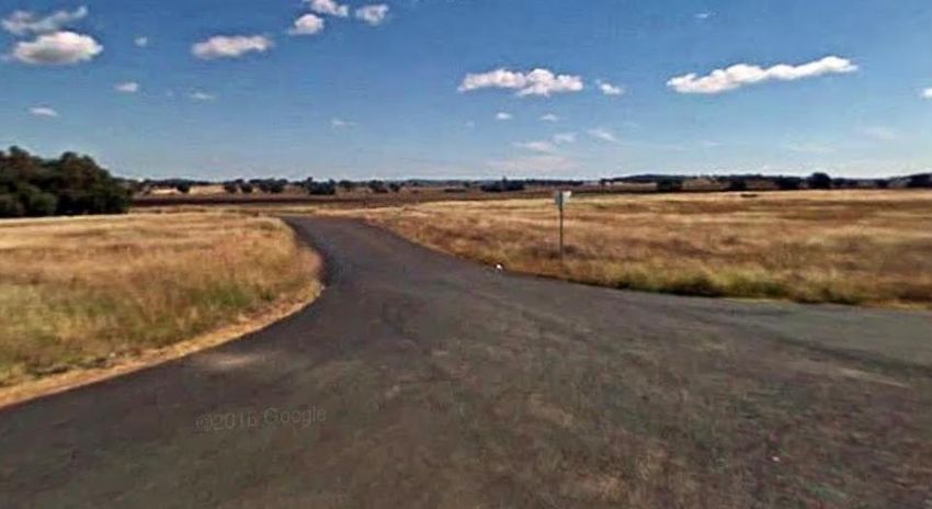
2.   Existing conditions
     2.1        The site
     The proposed WNSF is located within Dubbo Regional Council LGA on the western side of
     Goolma Road, south-west of its intersection with Campbells Lane.
     As indicated in Figure 2-1, the site is located in a RU1 (Primary Production) zone with the
     Wellington and Macquarie Correctional Centre to the east of the site zoned as SP2
     (Infrastructure). The land south of the site, at the intersection of Mitchell Highway and Goolma
     Road, is zoned as R5 (Large Lot Residential).
     The site currently consists predominately of greenfield area with the land used for agricultural
     purposes.
     Primary access to the proposed WNSF will be off Goolma Road, which currently consists of a
     residential driveway access located to the east of the site. South of the site is a local road
     network (Bela Vista Lane) providing access to the residential dwellings located within the R5
     Residential Zone.

     Figure 2-1 Land zoning

     Source: www.planningportal.nsw.gov.au – Modified by GHD

                             GHD | Report for Lightsource bp - Wellington North Solar Project Development, 12538291 | 4
2.2 Existing road network characteristics
This section provides an understanding of the existing road network surrounding the site.
2.2.1 Road hierarchy
Roads within NSW are categorised in the following two ways:
By Classification (ownership); and
By the function that they perform.
Road Classification
Roads are classified (as defined by the Roads Act 1993) based on their importance to the
movement of people and goods within NSW (as a primary means of communication).
The classification of a road allows Transport for NSW to exercise authority of all or part of the
road. Classified roads include Main Roads, State Highways, Tourist Roads, Secondary Roads,
Tollways, Freeways and Transitways.
For management purposes, Transport for NSW has three administrative classes of roads.
These are:
State Roads – Major arterial links through NSW and within major urban areas. They are
the principle traffic carrying roads and fully controlled by Transport for NSW with
maintenance fully funded by Transport for NSW. State Roads include all Tollways,
Freeways and Transitways; and all or part of a Main Road, Tourist Road or State
Highway.
Regional Roads – Roads of secondary importance between State Roads and Local
Roads which, with State Roads provide the main connections to and between smaller
towns and perform a sub arterial function in major urban areas. Regional roads are the
responsibility of councils for maintenance funding, though Transport for NSW funds some
maintenance based on traffic and infrastructure. Traffic management on Regional Roads
is controlled under the delegations to local government from Transport for NSW. Regional
Roads may own all part of all or part of a Main Road, Secondary Road, Tourist Road or
State Highway; or other roads as determined by Transport for NSW.
Local Roads – The remainder of the council controlled roads. Local Roads are the
responsibility of councils for maintenance funding. Transport for NSW may fund some
maintenance and improvements based on specific programs (e.g. urban bus routes, road
safety programs). Traffic management on Local Roads is controlled under the delegations
to local government from Transport for NSW.
Functional Hierarchy
Functional road classification involves the relative balance of the mobility and access functions.
Transport for NSW define four levels in a typical functional road hierarchy, ranking from high
mobility and low accessibility, to high accessibility and low mobility. These road classes are:
Arterial Roads – generally controlled by Transport for NSW, typically no limit in flow and
designed to carry vehicles long distance between regional centres.
Sub-Arterial Roads – can be managed by either Transport for NSW or local council.
Typically, their operating capacity ranges between 10,000 and 20,000 vehicles per day,
and their aim is to carry through traffic between specific areas in a sub region, or provide
connectivity from arterial road routes (regional links).
GHD | Report for Lightsource bp - Wellington North Solar Project Development, 12538291 | 5 Collector Roads – provide connectivity between local roads and the arterial road
network and typically carry between 2,000 and 10,000 vehicles per day.
Local Roads – provide direct access to properties and the collector road system and
typically carry between 500 and 4,000 vehicles per day.
The surrounding road network is shown in Figure 2-2.
Figure 2-2 Surrounding road network
Source: Transport for NSW maps – Modified by GHD
GHD | Report for Lightsource bp - Wellington North Solar Project Development, 12538291 | 62.2.2 Cobbora Road
Cobbora Road acts as a regional road in the vicinity of the WNSF running in a north-south
alignment. Cobbora Road connects to Mitchell Highway to the south and Golden Highway to the
north with priority-controlled intersections at both locations. The intersection of Cobbora Road
with Campbells Lane is a give-way priority-controlled intersection.
Cobbora Road has the following key features within proximity of site as outlined in Table 2-1
and shown in Figure 2-4.
Table 2-1 Cobbora Road key features
Feature Description
Carriageway Undivided carriageway, with typically one travel lane in each direction
Parking Unrestricted
Speed Limit No sign-posted speed limit (100 km/h)
Pedestrian Facilities No dedicated pedestrian facilities
Bicycle Facilities No dedicated bicycle facilities
Public Transport No dedicated public transport facilities; however a level crossing
exists across Cobbora Road approximately 80 m north of the Mitchell
Highway
Figure 2-3 Cobbora Road, west of the site (looking south)
Source: Google Maps Streetview
GHD | Report for Lightsource bp - Wellington North Solar Project Development, 12538291 | 72.2.3 Goolma Road
Goolma Road functions as a sub-arterial road with a north-south alignment. Goolma Road runs
between Gulgong in the north and Wellington in the south, forming priority-controlled
intersections at Mitchell Highway and Campbells Lane.
Goolma Road has the following key features within proximity of site as outlined in Table 2-3 and
Figure 2-4.
Table 2-2 Goolma Road key features
Feature Description
Carriageway Undivided carriageway, with a single travel lane in each direction. A
right turn lane is provided northbound on Goolma Road to access the
Wellington and Macquarie Correctional Centre
Parking Unrestricted
Speed Limit 100 km/h
Pedestrian Facilities No dedicated pedestrian facilities
Bicycle Facilities No dedicated bicycle facilities
Public Transport No dedicated public transport facilities
Figure 2-4 Goolma Road, east of the site (looking south)
Source: Google Maps Streetview
GHD | Report for Lightsource bp - Wellington North Solar Project Development, 12538291 | 82.2.4 Campbells Lane
Campbells Lane is located along the northern boundary of the WNSF. Campbells Lane is a local
road running in an east-west alignment from Goolma Road, east of the site, to Cobbora Road in
the west. Campbells Lane forms part of a priority-controlled intersection at both these locations.
Campbells Lane has the following key features within proximity of site as outlined in Table 2-3
and shown in Figure 2-5.
Table 2-3 Campbells Lane key features
Feature Description
Carriageway Undivided carriageway, with one travel lane in each direction
Parking Unrestricted
Speed Limit No sign-posted speed limit (100 km/h)
Pedestrian Facilities No dedicated pedestrian facilities
Bicycle Facilities No dedicated bicycle facilities
Public Transport No dedicated public transport facilities
Figure 2-5 Campbells Lane, north of the site (looking west)
Source: Google Maps Streetview
GHD | Report for Lightsource bp - Wellington North Solar Project Development, 12538291 | 92.2.5 Bela Vista Lane
Bela Vista Lane is located south of the WNSF. Bela Vista Lane is a local road running in an
east-west alignment from Goolma Road, east of the site, to Cobbora Road in the west. Bela
Vista Lane forms part of a priority-controlled intersection at both these locations.
Bela Vista Lane has the following key features within proximity of site as outlined in Table 2-3
and shown in Figure 2-6.
Table 2-4 Bela Vista Lane key features
Feature Description
Carriageway Undivided carriageway, with one travel lane in each direction; gross
load limit of 20 tonne
Parking Unrestricted
Speed Limit No sign-posted speed limit (100 km/h)
Pedestrian Facilities No dedicated pedestrian facilities
Bicycle Facilities No dedicated bicycle facilities
Public Transport No dedicated public transport facilities
Figure 2-6 Bela Vista Lane, north of the site (looking west)
Source: Google Maps Streetview
GHD | Report for Lightsource bp - Wellington North Solar Project Development, 12538291 | 102.2.6 Mitchell Highway
Mitchell Highway forms part of the arterial road network and runs from Dubbo in the north to
Bathurst to the south. In the vicinity of the WNSF, Mitchell Highway has a north-south alignment
and forms priority-controlled intersections at Goolma Road and Cobbora Road.
Mitchell Highway is a state road providing access from the WNSF to Wellington town centre.
Access to the WNSF via Mitchell Highway is provided through its intersection with Cobbora
Road south-west of the site and its intersection with Goolma Road south of the site.
Mitchell Highway has the following key features within proximity of site as outlined in Table 2-5
and shown in Figure 2-7.
Table 2-5 Mitchell Highway key features
Feature Description
Carriageway Undivided carriageway, with typically one travel lane in each direction.
An additional turning lane is provided in both directions on the
approach to Cobbora Road and a right turn lane from Mitchell
Highway northbound into Goolma Road.
Parking Unrestricted
Speed Limit 110 km/h with 80 km/h in the southbound direction near its
intersection with Cobbora Road and Goolma Road.
Pedestrian Facilities No dedicated pedestrian facilities
Bicycle Facilities No dedicated bicycle facilities
Public Transport No dedicated public transport facilities within the vicinity of the site.
Nearest bus stops are located on Mitchell Highway near Gobolion
Street, on both sides of the road.
Figure 2-7 Mitchell Highway, west of the site (looking west)
Source: Google Maps Streetview
GHD | Report for Lightsource bp - Wellington North Solar Project Development, 12538291 | 112.3 Existing road network performance
This section provides an understanding of the traffic volumes on the key roads in proximity to
the subject site.
2.3.1 Base (2018) traffic volumes
In order to identify the existing traffic volumes in proximity to the site, seven-day tube count was
undertaken by Matrix Traffic and Transport Data between 28 February and 6 March 2018 at the
following three locations, as shown in Figure 2-8.
Cobbora Road (approximately 500 m north of Bela Vista Lane).
Goolma Road (approximately 300 m south of the access point to the Wellington and
Macquarie Correction Centres).
Campbells Lane (approximately 400 m west of Goolma Road – approximately mid-way
between property access and 90 degree curve in the road).
During the 2018 base traffic surveys, the following projects were either in operation,
construction or planned for construction within the proximity of the WNSF:
Bodangora Wind Farm.
Macquarie and Wellington Correctional Centres.
Maryvale and Wellington Solar Farms.
The traffic survey volumes on the adjoining road network to the WNSF carried out in
February/March 2018 would have included the operation and construction of the existing
Macquarie and Wellington Correctional Centres and the construction activity of the Bodangora
Wind Farm. Since the completion of these traffic surveys, Macquarie and Wellington
Correctional Centres remain in operation and Bodangora Wind Farm has been completed.
Bodangora Wind Farm operational traffic impacts would be lighter than construction traffic
impacts as outlined in the NSW Bodangora Wind Farm Bodangora, Central Western NSW (MP
10_0157) Director-General’s Environmental Assessment Report by NSW Government Planning
and Infrastructure, dated June 2013. Therefore the 2018 survey is anticipated to represent a
higher than typical traffic volume along Goolma Road. There have been no significant
developments that may contribute to an increase in traffic flows along Cobbora Road and
Campbells Lane and therefore the 2018 survey data is anticipated to reflect typical traffic
volumes along these road networks.
Figure 2-8 Traffic survey locations
Source: Google Maps – Modified by GHD
GHD | Report for Lightsource bp - Wellington North Solar Project Development, 12538291 | 122.3.1.1 Cobbora Road traffic volumes
The identified daily traffic volumes on Cobbora Road is shown in Figure 2-9 with the surveyed
weekday average and seven day average (weekday and weekend) in Figure 2-10.
Figure 2-9 Daily traffic volumes on Cobbora Road
Figure 2-10 Weekday and seven day average hourly traffic profile on
Cobbora Road (two-way)
GHD | Report for Lightsource bp - Wellington North Solar Project Development, 12538291 | 13Table 2-6 outlines the highest recorded vehicle movements within an hour period during the AM
and PM periods, while Table 2-7 surmises 85 percentile traffic speeds and the percentage of
heavy vehicles on Cobbora Road.
Table 2-6 Peak hour average surveyed traffic volume on Cobbora Road
Cobbora Road Average Weekday Average Weekday Saturday Peak
AM Peak Hour PM Peak Hour Hour
(veh/h)* (veh/h)* (veh/h)*
Northbound 20 19 16
Southbound 14 29 20
Total 34 49 36
Notes:
(*) veh/h = vehicles per hour
Table 2-7 Key traffic data summary on Cobbora Road
Key Data Description Amount
Weekday % Heavy Vehicles 25 %
Weekend % Heavy Vehicles 12 %
85 percentile speed 98.1 km/h
The above traffic data is representative of typical traffic flow and conditions to align with
hierarchy of a regional / local road network as described in section 2.2.1.
2.3.1.2 Goolma Road traffic volumes
The identified daily traffic volumes on Goolma Road is shown in Figure 2-11 with the surveyed
weekday average and seven day average (weekday and weekend) in Figure 2-12.
Figure 2-11 Daily traffic volumes on Goolma Road
GHD | Report for Lightsource bp - Wellington North Solar Project Development, 12538291 | 14Figure 2-12 Weekday and seven day average hourly traffic profile on Goolma
Road (two-way)
Table 2-8 outlines the highest recorded vehicle movements within an hour period during the AM
and PM periods, while Table 2-9 surmises 85 percentile traffic speeds and the percentage of
heavy vehicles on Goolma Road.
Table 2-8 Peak hour average surveyed traffic volume on Goolma Road
Goolma Road Average Weekday Average Weekday Saturday Peak
AM Peak Hour PM Peak Hour Hour
(veh/h)* (veh/h)* (veh/h)*
Northbound 157 66 57
Southbound 44 135 94
Total 201 201 151
Notes:
(*) veh/h = vehicles per hour
Table 2-9 Key traffic data summary on Goolma Road
Key Data Description Amount
Weekday % Heavy Vehicles 18 %
Weekend % Heavy Vehicles 11 %
85 percentile speed 104.7 km/h
The above traffic data is representative of typical traffic flow and conditions to align with
hierarchy of a regional / collector road network as described in section 2.2.1.
GHD | Report for Lightsource bp - Wellington North Solar Project Development, 12538291 | 152.3.1.3 Campbells Lane traffic volumes
The identified daily traffic volumes on Campbells Lane is shown in Figure 2-13 with the
surveyed weekday average and seven day average (weekday and weekend) in Figure 2-14 .
Figure 2-13 Daily traffic volumes on Campbells Lane
Figure 2-14 Weekday and seven day average hourly traffic profile on
Campbells Lane (two-way)
GHD | Report for Lightsource bp - Wellington North Solar Project Development, 12538291 | 16Table 2-10 outlines the highest recorded vehicle movements within an hour period during the
AM and PM periods, while Table 2-11 surmises 85 percentile traffic speeds and the percentage
of heavy vehicles on Campbells Lane.
Table 2-10 Peak hour average surveyed traffic volume on Campbells Lane
Campbells Lane Average Weekday Average Weekday Saturday Peak
AM Peak Hour PM Peak Hour Hour
(veh/h)* (veh/h)* (veh/h)*
Eastbound 4 3 1
Westbound 1 5 4
Total 5 8 5
Notes:
(*) veh/h = vehicles per hour
Table 2-11 Key traffic data summary on Campbells Lane
Key Data Description Amount
Weekday % Heavy Vehicles 12 %
Weekend % Heavy Vehicles 7%
85 percentile speed 91.9 km/h
The above traffic data is representative of typical traffic flow and conditions to align with
hierarchy of a local road network as described in section 2.2.1.
2.4 Crash data review
GHD utilised the Transport for NSW Centre for Road safety website to review the crash
statistics for a five-year period (2012-2016) for roads within proximity of the proposed WNSF.
Crash locations on Goolma Road and Cobbora Road near the proposed WNSF are shown in
Figure 2-15
Figure 2-15 Study area crash data
Source: Transport for NSW Centre for Road Safety – Modified by GHD
GHD | Report for Lightsource bp - Wellington North Solar Project Development, 12538291 | 17There was a total of five (5) crashes recorded within proximity to the WNSF over the five year
period between 2014 – 2018. Of the five crashes, three (3) were recorded on Goolma Road and
two (2) was located on Cobbora Road. Of the recorded crashes resulted in one (1) serious
injury, three (3) moderate injuries and one minor/other injuries. All recorded crashes occurred
within the daylight period and summarised by crash type in Table 2-12.
Table 2-12 Crash summary
Location Rum Code Description Number of Injuries
Goolma Road 80 Vehicle steered off road to the left /right 1 serious
71 Vehicle steered off road to the left and 1 moderate
struck an object
47 Vehicle emerging from driveway 1 moderate
Cobbora Road 55 Vehicle pulling out resulting in rear end 1 moderate
22 Rear end 1 minor/other injury
2.5 Public and active transport
Given the rural nature of the location, there are no formalised pedestrian or cycle facilities on
the road network surrounding the site.
Wellington Railway Station, located approximately 7 km south of the site, is serviced by regular
train services to Dubbo, Orange, Bathurst, Lithgow and Sydney. Charter coach services also
operate between Wellington and major centres.
A local bus service (TLDW – Wellington to Dubbo) operates around the town of Wellington, as
shown in Figure 2-16, operates four daily services Monday to Friday.
There are no public transport services that run along Goolma Road or Cobbora Road to the site.
Accordingly, the vast majority of trips generated by the construction activity and workers are
expected to occur using private vehicles or arranged coach / transport services to and from the
site. There are three designated school bus routes that run within proximity of the site, as shown
in Figure 2-17.
Figure 2-16 Wellington Town Centre bus route
Source: Ogden Coach Services – Modified by GHD
GHD | Report for Lightsource bp - Wellington North Solar Project Development, 12538291 | 18Figure 2-17 School bus routes
Source: Ogden Coach Services – Modified by GHD
GHD | Report for Lightsource bp - Wellington North Solar Project Development, 12538291 | 193. Traffic impact assessment
This section of the report provides details and assessment of the estimated traffic generation
during the construction of the WNSF, based upon estimated staffing numbers and heavy vehicle
movements. Vehicle movements were estimated by Lightsource bp based on a review of actual
construction traffic generation across its Australian portfolio and extrapolated based of the data
to reflect WNSF potential trip generation during construction.
Construction activity is proposed to operate from 7 am to 6 pm Monday to Friday, and 8 am to 1
pm Saturday. No construction activity will occur on Sunday and public holidays without prior
approval. However, it is noted that during the COVID-19 pandemic, the permitted construction
hours have been granted an exemption on the nearby Wellington Solar Farm, with construction
activity permitted 7 am to 6 pm, seven days per week. This might be replicated at the WNSF.
The internal access and parking arrangement for the proposal are currently unknown and have
therefore, has not been assessed as part of the traffic study.
3.1 Wellington North Solar Farm life cycle overview
The WNSF is expected to proceed through mobilisation, construction, commissioning, operation
and decommissioning stages typical of Photovoltaic (PV) generation facilities.
Mobilisation would be expected to occur for the first 1-3 months of the project delivery timeframe
and traffic movements might include:
Light vehicles to mobilise workers (daily) to and from site.
Shuttle bus services to facilitate workers to and from the site on a daily basis from nearby
population centres (i.e. Wellington, Dubbo and Orange).
Delivery of infrastructure including temporary offices and associated equipment, power
generation equipment, ablutions.
Delivery of equipment and machinery for civil construction, clearing (if required) and
general site establishment.
Delivery of structural components and some PV equipment.
More intense construction would be expected to follow during months 3-14 to achieve
mechanical completion with the following traffic movements:
Light vehicles to mobilise workers (daily) to and from site – numbers ramping up from
mobilisation.
Shuttle bus services to facilitate workers to and from the site on a daily basis from nearby
population centres (i.e. Wellington, Dubbo and Orange).
Delivery of equipment and machinery for structural, electrical and civil construction
activities.
Ongoing delivery of PV and electrical equipment including deliveries of major equipment
such as inverters, switchgear, transformer etc.
Trucks for removal of waste.
Following mechanical completion, the site will move into a commissioning phase estimated from
months 15-18 where equipment deliveries are significantly reduced and the workforce is also
reduced. During commissioning the majority of traffic would be expected to be light vehicles for
personnel movement.
GHD | Report for Lightsource bp - Wellington North Solar Project Development, 12538291 | 20Following commissioning the site will move to operations phase which would be expected to
extend for the life of the asset with very limited light vehicle movements predominately for
routine operations and maintenance personnel and activities.
At the end of the useful life of the asset, it is envisaged that decommissioning would take place
which would involve mobilisation of a workforce and additional temporary facilities, and then
move to the removal of equipment and infrastructure. At this time it is expected that significant
movements of light vehicles and trucks for transporting waste will occur. The decommissioning
phase would be expected to last less than eight months.
3.2 Construction traffic generation
3.2.1 Daily traffic
Daily construction traffic generation provided by Lightsource bp was based upon the current
construction activity across Lightsource bp's Australian portfolio and extrapolated to be
representative of the WNSF.
During its peak construction period, consideration was given to the workforce (consisting of
some 400 workers) will be transported to and from the site and nearby population centres (i.e.
Wellington, Dubbo and Orange) via a shuttle bus system. Such system aims to reduce traffic
generation within the surrounding road network, reduction of parking demand on site and
improved safety for the workers and the public, by reducing the fatigue of workers that would
generally be required to drive between accommodation and the site.
Based on the information estimated by the client, the daily vehicle two-way trips outlined for the
project during the peak construction activity is summarised in Table 3-1
Table 3-1 Peak daily trip generation (two-way)
Vehicle Type Number of Trips
(two-way)
Light Vehicles 132
Staff Shuttle Buses 80
Heavy Vehicles 55
Total 267
The client has advised that at the peak of the construction, it is anticipated that up to 400 site
personnel will be required to undertake the works. They have advised that a shuttle bus system
will be in place to transport workers to the site consisting of a typically 20 seater buses. Based
on an anticipated modal split of 80 percent of the workers travelling by shuttle bus, it is
estimated that this could generate 16 inbound and 16 outbound trips during each of the AM and
PM peak periods. Additionally, the remaining 20 percent of workers travelling by private means
would potentially car-pool. Assuming a rate of 1.2 persons per private vehicle, it is anticipated
that such would generate up to 66 inbound trips in the AM peak period and visa-versa in the PM
peak period (total of 132 daily trips).
Heavy vehicle movements will be spread throughout the day.
3.2.2 Peak hourly traffic generation and distribution
For a worst-case scenario for the impacts of the road network, it has been assumed that the
peak traffic associated with construction activity would be during the arrival and departures of
the site workers and occur within the road network AM and PM peak hour period. However,
while the assessment has been undertaken with comparison to the road network peak periods,
it is noted that staff arrival and departure pattern may not necessarily coincide with the road
network peak.
GHD | Report for Lightsource bp - Wellington North Solar Project Development, 12538291 | 21It is expected that the heavy vehicle movements (55 two way trips) generated by the
construction activity would be spread throughout the day with up to 6 (approximately 10 percent)
two-way trips occurring within the same peak hour of the workers arrival and departure period.
Lightsource bp has advised that all construction traffic is proposed to arrive and depart at the
location of the existing domestic driveway access on Goolma Road located on the eastern site
boundary (approximately 195 m south of the entry to Wellington Correctional Centre). Travel to
the Goolma Road is via the Mitchell Highway located south to the site (to/from Wellington).
The 2018 peak hour AM and PM movements and construction traffic approach routes trip
generation within the vicinity of the site access are outlined in Figure 3-1 and Figure 3-2,
respectively. The AM and PM peak hour has been reviewed for a worst-case scenario.
Figure 3-1 AM peak hour construction vehicle movements
Figure 3-2 PM peak hour construction vehicle movements
GHD | Report for Lightsource bp - Wellington North Solar Project Development, 12538291 | 223.3 Mid-block assessment
Based on the above information summary of estimated construction vehicle movements, a
review of the existing peak traffic and combined construction movement was undertaken with
reference to Roads and Maritime Services Guide to Traffic Generating Developments (2002).
This outlines mid-block road capacity Levels of Service based on traffic flows per direction per
lane to guide road capacity Level of Service as outlined in Table 3-2.
Table 3-2 Mid-block level of service (peak flows per direction)
Level of Service Peak Hour Volume Peak Hour Volume
(veh/h*) (veh/h*)
One Lane Two Lane
A 200 900
B 380 1400
C 600 1800
D 900 2200
E 1400 2800
Source: Guide to Traffic Generating Developments (Roads and Maritime Services 2002)
*Note veh/h = vehicles per hour
Table 3-3 outlines the Level of Service of the road network with respect to the mid-block level of
service.
Table 3-3 Peak hour mid-block level of service
Location Base (2018) Additional Total Vehicles Level of
vehicles vehicles (each-way) Service
(each-way) (each-way)
AM peak hour
Goolma Road
- Northbound 157 85 242 B
- Southbound 44 19 63 A
Total 201 104 305
PM peak
Goolma Road
- Northbound 66 19 85 A
- Southbound 135 85 220 B
Total 201 104 305
The above review shows that the mid-block level of service is good. However, it is
recommended that the existing road environment pavement conditions be reviewed within the
proximity of the site and access configuration.
3.4 Intersection treatment
3.4.1 Turn treatment
The Austroads Guide to Road Design Part 4A: Unsignalised and Signalised Intersections
provides warrants that apply to major road turn treatments with respect to the provision of basic,
auxiliary and channelised lanes along the major road. For the purpose of this assessment, the
graph for a speed of higher than or equal to 100 km/h has been applied.
A review was undertaken at the intersection of Goolma Road and the proposed site access as
shown in Figure 3-3. This was established on the base 2018 traffic survey and the construction
traffic volumes, notably for the left turn movement from the major road (considered as the worst
turn movement) as vehicles will be arriving from the south during the AM period. Vehicles
GHD | Report for Lightsource bp - Wellington North Solar Project Development, 12538291 | 23exiting the site (primarily in the PM period) will exit via the access road (minor road) and will be
required to give way to through travelling vehicles along Goolma Road. Any such queuing that
may result, will be within the site and any proposed intersection upgrade is to ensure suitable
visibility is maintained from the site, refer to section 3.4.2.
Figure 3-3 Intersection left turn treatment review
Source: Austroads Guide to Road Design – Part 4A: Unsignalised and Signalised Intersections – modified by GHD -
Based on the warrants, it is supposed that consideration could be given to the provision of a
short auxiliary left turn lane (AUL(S)) from Goolma Road into the site. Although it is anticipated
that all vehicles will be travelling to and from the south, incorporating shoulder widening on the
eastern verge (i.e. BAR type treatment), would facilitate improved safety for southbound
movement as well as facilitating the turn path of larger vehicles exiting the site, if required.
In conjunction with the AUL(S)/BAR treatment, it is recommended to advise travelling motorists
of the potential increase in turning movements at the site access. This may incorporate truck-
turning advance warning signs provided on both the northern and southern approaches to the
intersection.
Currently, the site access intersection does not provide the AUL(S)/BAR treatment, with no
shoulder or road widening provided on the major road. It is considered that Goolma Road, at the
site access, be constructed in line with an AUL(S)/BAR treatment as shown in Figure 3-4. This
is to include an auxiliary lane and shoulder widening on the western and eastern road
alignment, respectively.
The treatments should be designed to accommodate articulated vehicles up to 19 m in length
(anticipated typical maximum vehicle length). Larger vehicles will require special permit and
traffic management when required.
GHD | Report for Lightsource bp - Wellington North Solar Project Development, 12538291 | 24Figure 3-4 AUL(S)/BAL turn treatments
Source: Austroads Guide to Road Design – Part 4A: Unsignalised and Signalised Intersections -
3.4.2 Sight lines
The Austroads Guide to Road Design Part 3: Geometric Design (Table 5.5: Truck stopping sight
distances) specifies that (accounting for a reaction time of two seconds) for roads with an
operating speed of 100 km/h, a minimum sight distance of 191 metres should be provided. A
desktop review using Google imagery indicates that these sight lines can be achieved. This
would be subject to further assessment when developing a concept and detailed intersection
plan and review of current on-site conditions (e.g. vegetation growth).
3.5 Oversize vehicles
The number of oversize vehicles is anticipated to be low for the construction of the WNSF.
Oversize vehicles will require permits from Transport for NSW and suitable traffic management
subject to the transportation of the type of oversized vehicles that will need to be used. Oversize
vehicle routes are to be carried out where possible on designated heavy vehicle routes or routes
approved by Transport for NSW. It is proposed that such routes will be via the Golden Highway
(north of the site) or the Mitchel Highway (south of the site), Goolma Road and the site access.
Additionally, oversize traffic movements should be carried out, where possible, outside peak
road network periods where possible minimising the impacts on the road network.
An example of the potential oversize vehicle that would be required to transport the
transformers is a flatbed trailer as shown in Figure 3-5. The vehicle type and size is to be
coordinated to be suitable for transportation of the plant and agreed with the governing
authority.
GHD | Report for Lightsource bp - Wellington North Solar Project Development, 12538291 | 25Figure 3-5 Oversized vehicle example
Source: AutoTurn computer aided program
3.6 Cumulative construction traffic impacts
During the 2018 base traffic surveys, the following projects were either in operation,
construction or planned for construction within the proximity of the WNSF.
Bodangora Wind Farm.
Macquarie and Wellington Correctional Centres.
Maryvale and Wellington Solar Farms.
The traffic surveys volumes on the adjoining road network to the WNSF carried out in
February/March 2018 would have included the operation and construction of the existing
Macquarie and Wellington Correctional Centres and the construction activity of the Bodangora
Wind Farm. Since the completion of these traffic surveys, Macquarie and Wellington
Correctional Centres remains in operational and Bodangora Wind Farm has been completed.
Bodangora Wind Farm operational traffic impacts would be lighter than construction traffic
impacts as outlined in the NSW Bodangora Wind Farm Bodangora, Central Western NSW (MP
10_0157) Director-General’s Environmental Assessment Report by NSW Government Planning
and Infrastructure, dated June 2013e, therefore the 2018 survey is represent a higher than
typical traffic volume along Goolma Road.
During the construction of the WNSF, the Wellington Solar Farm is anticipated to be completed,
with Maryvale Solar Farm and the recently submitted Uungula Wind Farm due for construction
which are anticipated to commence construction is late 2021. Such construction of these
facilities could coincide with the WNSF construction activities.
Locations of the existing and future facilities within proximity of the WNSF is shown in Figure
3-6.
GHD | Report for Lightsource bp - Wellington North Solar Project Development, 12538291 | 26Figure 3-6 Existing and future facilities within proximity of Wellington North
Solar Farm
Source: Google Maps – Modified by GHD
A summary of the traffic impacts associated with the construction activity of the facilities that
may occur concurrently with WNSF is summarised below.
Maryvale Solar Farm
Source: Maryvale Solar Farm Environmental Impact Statement prepared by Pitt & Sherry Pty
Ltd dated 12 November 2018.
Access routes within vicinity of the WNSF site include:
– Mitchell Highway from Dubbo to Wellington.
– Cobbora Road and Maryvale Road.
– Maryvale Solar Farm site Access off Seatonville Road.
Period of construction: 12 months.
Staff numbers: Up to 150 personnel.
Estimated typical vehicle movements:
– Light vehicles: 75 vehicle movements per day.
– Heavy vehicles: 20 vehicle movements per day.
– Use of a shuttle bus for workers to travel to and from site.
It is noted that construction vehicle activity is to utilise Cobbora Road to access the site. The
WNSF proposes to use Goolma Road, therefore it is anticipated that there will be no cumulative
impacts on the local road network associated with these two sites.
However, it is noted that the construction activity for Maryvale Solar Farm and the proposed
WNSF both utilise the Mitchell Highway as a common route to access each proposed
development. The Mitchell Highway is a state-designated road which has the capacity to cater
for regional and state traffic flow. It is considered that the cumulative impact from both proposed
GHD | Report for Lightsource bp - Wellington North Solar Project Development, 12538291 | 27development’s construction activity will have a minimal adverse impact on the network efficiency
of the state road network. This assumption is supported by the Department of Planning
Environment Maryvale Solar Farm State Significant Development Assessment (SSD 8777)
report dated December 2019, which outlines:
“Other than the Wellington North Solar Farm, no other approved or proposed project in the
Wellington area shares a common haulage route, except for sections of Mitchell Highway, which
is part of the State road network and has sufficient capacity to absorb the associated
construction traffic. For this reason, the Department considers that there would be negligible
cumulative traffic impacts on the State road network and no road upgrades would be required in
relation to cumulative traffic volumes.”
Uungula Wind Farm
Source: Uungula Wind Farm Transport Assessment prepared by Samsa Consulting dated April
2020.
Access routes within vicinity of the WNSF site include:
– From Golden Highway along Saxa Road (also known as Cobbora Road to Michell
Highway.
– Mitchell Highway to Goolma Road.
– Goolma Road to Twelve Mile Road.
– Twelve Mile Road to the Uungula Wind Farm site.
Period of construction: 24 to 30 months.
Staff numbers: Up to 250 personnel.
Estimated typical vehicle movements (Goolma Road):
– Light vehicles: 240 vehicle movements per day (120 vehicles during peak hour).
– Heavy vehicles: 90 vehicle movements per day (16 vehicles during peak hour).
– Oversize/Overmass (OSOM) vehicles: Low volume and only on demand at specific
times when required.
– Possible use of a shuttle bus for workers to travel to and from site.
It is noted that the construction activity for Uungula Wind Farm and the proposed WNSF both
utilise Goolma Road for a section between the Mitchell Highway and Twelve Mile Road.
A summary of the cumulative traffic impact on Goolma Road between the Mitchell Highway and
Twelve Mile Road is outlined in Table 3-4 and is also compared to the mid-block level of service
as defined in Table 3-2.
GHD | Report for Lightsource bp - Wellington North Solar Project Development, 12538291 | 28Table 3-4 Goolma Road cumulative peak hour mid-block level of service
Location Base (2018) Additional Additional Total Level of
vehicles vehicles vehicles Vehicles Service
(each-way) * (each-way) (each-way) (each-way)
WNSF Uungula Wind
Farm ^
AM peak hour
Goolma Road
- Northbound 157 85 136 378 B
- Southbound 44 19 0 63 A
Total 201 104 136 441
PM peak
Goolma Road
- Northbound 66 19 0 85 A
- Southbound 135 85 136 356 B
Total 201 104 136 441
Notes:
(*) The 2018 traffic survey data which is located north of Twelve Mile Road. It is noted that Twelve Mile Road is a low
volume road, it is therefore considered that the 2018 survey data can be representative of potential traffic volumes on
Goolma Road south of Twelve Mile Road.
(^) Assumes all the Uungula Wind Farm peak hour traffic volumes from the Samsa Consulting Transport Assessment
are inbound from Wellington in the AM peak and outbound to Wellington the PM peak.
Based upon the mid-block assessment of the road network and of the project traffic generation
and the WNSF and cumulative impacts associated with Uungula Wind Farm, the major road
network (Goolma Road) has additional capacity to cater for additional traffic flow.
With reference to the intersection of Goolma Road and Twelve Mile Road, the Uungula Wind
Farm Transport Assessment prepared by Samsa Consulting outlined that:
“Under current traffic volumes, the current Goolma Road / Twelve Mile Road intersection layout
(BAR: basic right-turn / BAL: basic left-turn) is considered to be adequate. Sight distance is
more than satisfactory in all directions and the T-junction is quite wide with separate turn areas
for east and west movements.
During Project construction, the increased traffic generation and in particular, the higher turning
movements at the subject intersection may warrant auxiliary and/or protected (channelised) turn
lane intersection treatments, eg. AUR: auxiliary right-turn / AUL: auxiliary left-turn or CHR:
channelised right-turn / CHL: channelised left-turn”
It should be noted that the WNSF does not contribute to the higher turn movements within the
intersection, with vehicles associated with WNSF travelling along the major road (Goolma Road)
straight through the intersection.
3.7 Operational phase traffic movements
It is considered that the traffic generated during operation will consist of minor traffic movements
in association with the maintenance of the WNSF. Although no specific details of on-site vehicle
movements have been provided by the client, it is anticipated that traffic movement required
during maintenance and monitoring of the WNSF would be less than construction traffic.
Therefore, the road network would continue to operate satisfactorily post-construction, subject
to the recommendations outlined in the construction traffic generation assessment being carried
out.
GHD | Report for Lightsource bp - Wellington North Solar Project Development, 12538291 | 29You can also read