Bushfire Emergency Evacuation Plan Proposed Saw Mill - Shire of ...
←
→
Page content transcription
If your browser does not render page correctly, please read the page content below
Attachment 10.1.3.5

                                                                    Bushfire Emergency
                                                                       Evacuation Plan
                                                                     Proposed Saw Mill

                                                                               1548 Kargotich Road
                                                                                Mardella, WA, 6125

                                                                                               4th February 2019

Suite 14 Centre Park Business Centre        Telephone | +61 8 9355 5484        WABAL is a subsidiary of WABCA Pty Ltd
755 Albany Hwy East Victoria Park WA 6101   Email | info@WABAL.com.au          ATF The Greenwood Trust
                                            www.WABAL.com.au                   ABN 14566572499
                                                                  Ordinary   Council
                                                                               REG NO: Meeting
                                                                                       226         15 April 2019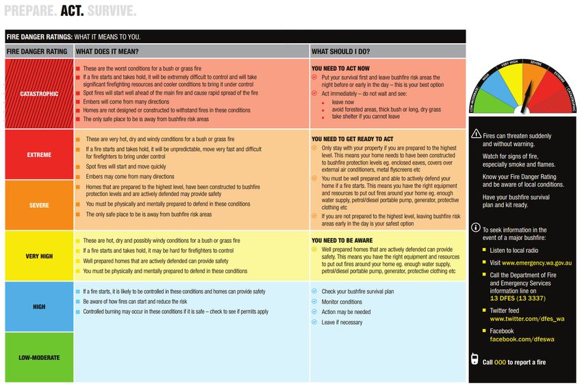
Attachment 10.1.3.5

                                                           Table of Contents
1.0      Introduction ............................................................................................................................................ 3

2.0      Aim .......................................................................................................................................................... 4

3.0      Annual Review ......................................................................................................................................... 4

4.0      Emergency Planning Committee - Roles and Responsibilities .................................................................. 5

5.0      Bushfire Readiness .................................................................................................................................. 6
  5.1      Site Information.................................................................................................................................... 6
  5.2      Site Fire Wardens ................................................................................................................................. 7
  5.3      Emergency Contacts ............................................................................................................................. 7
  5.4      The Area Response Map – Awareness and Readiness Zones................................................................. 8
  5.5      Fire Danger Rating (FDR)....................................................................................................................... 9
  5.6      Bushfire Warning System.................................................................................................................... 10
  5.7      Procedures for Preparation of the Site ............................................................................................... 13
6.0      Action Required - Bushfire Response ..................................................................................................... 14
  6.1      Safety Objective for Saw Mill .............................................................................................................. 14
  6.2      Early Evacuation – Persons with Special Needs................................................................................... 14
  6.3      Safe Evacuation Route Options ........................................................................................................... 14
  6.4      No Bushfire Known - Forecast ‘Severe’, ‘Extreme’ or ‘Catastrophic’ .................................................. 15
  6.5      No Bushfire Known - FDR Forecast ‘Very High’ ................................................................................... 15
  6.6      No Bushfire Known - FDR Forecast ‘High’ or ‘Low’ .............................................................................. 15
  6.7      Bushfire Present within the Bushfire Awareness Zone (BAZ) .............................................................. 15
  6.8      Bushfire Present within the Evacuation Readiness Zone (ERZ) ............................................................ 16
  6.9      Procedures for Sheltering in Place ...................................................................................................... 16
  6.10     Return Procedures Post Evacuation .................................................................................................... 17
7.0      Appendices – Additional Information and Maps .................................................................................... 18
  7.2      Community Member Contact Details.................................................................................................. 19
  7.3      Guidelines for Sheltering in Vehicle .................................................................................................... 20
  7.4      Area Response Map............................................................................................................................ 21
  7.5      Site Response Map ............................................................................................................................. 22

                                                                                        Ordinary Council Meeting 15 April 2019                                         1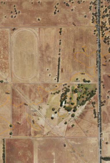
Attachment 10.1.3.5

Approved by:

John Greenwood
MSc(Curtin) BAppSc (Building Surveying) MAIBS, MAIB
Director

 Revision Number     File Name                     Issue Date                       Prepared By:

 Rev 1               BEEP – J009167                21/09/2018                       John Greenwood
                                                                                    BPAD Level 2

 Rev 2               Bushfire      Emergency 4/02/2019                              John Greenwood
                     Evacuation Plan (BEEP)                                         BPAD Level 2
                     Amendment in response
                     to comments from the
                     Shire    of  Serpentine-
                     Jarrahdale

Disclaimer: This is Bushfire Emergency Evacuation Plan (BEEP) is to be considered as part of a parent
Development Application for planning consent to carry out development as specified in this report. Each
standard specified in this report must be considered as a minimum standard and they do not guarantee safety
in the event of a bushfire due to the unpredictable nature and behaviour of bushfire. All details and predictions
together with any recommendations made in this report associated with this specific project are made in good
faith on the basis of information available to WABAL at the time of writing. The achievement of the level of
implementation and maintenance of the fire management plan will be the responsibility of the landowners or
occupiers over which WABAL has no control.

Notwithstanding anything contained therein, WABAL will not, except as the law may require, be liable for any
loss or other consequences (whether or not due to the negligence of the consultants, their servants or agents)
arising out of the services rendered by the consultants.

                                                            Ordinary Council Meeting 15 April 2019             2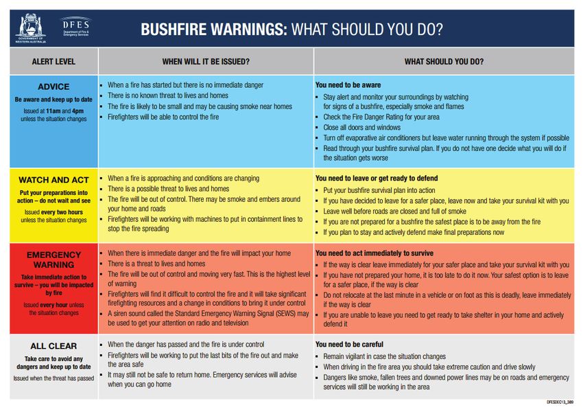
Attachment 10.1.3.5

    1.0      Introduction

Bushfires present a significant risk to people, property and the environment. Each year, thousands of bushfires
destroy or damage houses, sheds and garages, commercial and industrial buildings, vehicles and vast hectares
of bushland across Western Australia. People have also been killed or seriously injured during bushfires.
Therefore, preparedness for the event of a bushfire through the implementation of an Emergency Evacuation
Plan is crucial for maintaining safer communities and of the very highest priority mitigating the potential loss
of life and the associated financial and emotional impact.

This Bushfire Evacuation Plan has been developed for the occupants of the proposed Timber Processing Facility
(Saw Mill) located at 1548 Kargotich Road, Mardella (the site). The current operation of the site consists of two
houses and farm buildings surrounded by managed landscaped areas located on the southern half of the
property, with general farmland on the remainder of the site. The proposed development includes the
construction of a timber processing facility north of the current operation of the site on the general farmland.

The application of State Planning Policy 3.7 is triggered by the site being located within an area that is designated
as being prone to bushfire attack. The proposal consists of a development application where a Bushfire Attack
Level (BAL) rating of BAL-12.5 applies. SPP 3.7 recognises that vegetation is not necessarily the only fuel in a
bushfire event and that certain land uses may potentially ignite a bushfire, prolong its duration, or increase its
intensity. The proposal is further defined as being a high risk land use in accordance with Policy Measure 6.6 of
State Planning Policy 3.7 and Section 5.6 of the Guidelines for Planning in Bushfire Prone Areas.

This Bushfire Evacuation Plan has been prepared in accordance with the following legislation, policies and
guidelines:

    ·     State Planning Policy 3.7 – Planning in Bushfire Prone Areas (December 2015)
    ·     Guidelines for Planning in Bushfire Prone Areas Version 1.3 (WAPC and Department of Fire and
          Emergency Services December 2017).
    ·     Building Act 2011
    ·     Building Regulations 2012
    ·     Department for Planning and Infrastructure and Department of Fire and Emergency Services, 2017
    ·     Australian Standards (AS) 3959-2009 Construction of buildings in bushfire prone- areas, Standards
          Australia, 2009 (Amendment No. 3)
    ·     Evacuation Planning Handbook 4, 3rd edition (2013) AEMI
    ·     Bush Fires Act 1954 (as amended)
    ·     AS 3745-2010 Planning for Emergencies in Facilities
    ·     Shire of Serpentine-Jarrahdale Firebreak Notice

Land owners or occupiers should note that they have a responsibility to read, understand and implement the
requirements of this Bushfire Emergency Evacuation Plan. In the event of a bushfire on or near the development
area, fire agencies may not be in a position nor have resources available to assist occupants that are in danger.
Therefore, it is necessary for preparedness that that an emergency evacuation plan in implemented by the land
owners and/or persons accountable for the safety of staff and occupants at the Saw Mill located at 1548
Kargotich Road, Mardella.

                                                              Ordinary Council Meeting 15 April 2019               3
Attachment 10.1.3.5

    2.0       Aim

The aim of this Bushfire Evacuation Plan is to provide strategic guidance to the owners and occupants of the
subject property with respect to:

    ·     Provision of information and tools to assist with preparation for a future bushfire event
    ·     Provide actionable guidance in the event of a bushfire threatening the property

The emphasis of this plan is on the safety of lives rather than preservation of property, therefore, the guidance
provided is based on information that is easily obtained and the timing of actions that have a large safety
margin built in.

    3.0       Annual Review

Prior to the start of each bushfire season all bushfire documents should be reviewed, and revised where
necessary in line with current legislation, policy and practice where appropriate. Each method and action will
require a responsible and appropriately qualified person to undertake each review and carry our inspections
of active fire protection systems. WABAL also recommends full emergency evacuation drills at the beginning
of each fire season for all staff employed at this facility. The following shall be maintained at all times and
reviewed annually:

    ·     A Contractors/Visitors sign in/out register
    ·     Staff induction records and evacuation training

All current Site and Area Response Maps, Property Preparation table and the Emergency Contacts table must
be displayed in the nominated emergency assembly area and any public buildings on the property.

   Date                       Plan            Plan            Action              Person Responsible
                            Reviewed        Revision        Procedures
                                            Required         Practiced
                                             Yes/No                            Name               Signature

                                                              Ordinary Council Meeting 15 April 2019              4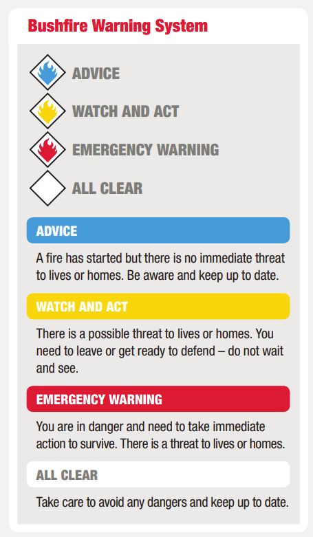
Attachment 10.1.3.5

    4.0     Emergency Planning Committee - Roles and Responsibilities

An Emergency Planning Committee (EPC) must be established by owners/managers. This is group comprised
of people who may work or occupy the facility. Their role is to actively participate in the planning process and
identify the roles and likely participants who will be responsible for implementing each section of this plan
and its procedures during an emergency (Emergency Control Organisation – ECO). The people with the
primary responsibilities of implementing this fire plan are the owners of the facility and/or their appointed
managers/site manager. The ECO members need to ensure that whenever the site is occupied that there are
members available to respond to an emergency, and enable the site to be evacuated quickly and efficiently if
required.

Roles and responsibilities with this plan will need to be assigned to staff in each relevant section of this plan
where indicated. Where required these responsible persons shall be provided with sufficient level of training
to undertake such responsibilities.

As a minimum, members of the ECO should include:
    · Site Manager;
    · Site Operations representative, including a designated Chief Warden and/or Fire Wardens.

The positions and responsibilities should be kept in a register and updated and available for the Chief Warden
when required. The details shall be displayed on an evacuation route map that will be prepared and installed
in prominent places within the venue.

                                                             Ordinary Council Meeting 15 April 2019                 5
Attachment 10.1.3.5

  5.0     Bushfire Readiness

          5.1      Site Information

                                      Saw Mill Mardella

Property Address                         1548 Kargotich Road, Mardella 6125

Property Size                            395514.124 m2
Onsite vegetation                        Grassland and Woodland

Offsite vegetation                       Grassland and Woodland

Nearest Road                             Kargotich Road
Name of Nearest Cross Road and
                                         Randell Road via Kargotich Road (~885 metres)
Distance
Access & Egress                          Kargotich Road
                                         There must be a dedicated static water supply with a
Water Supply onsite                      minimum effective capacity of 10,000 Litres on the
                                         site.
Maximum Occupants onsite                 50 people
                                         Storage, log processing, staff, office buildings and
Assets on site
                                         associated saw mill facilities
                                         Bulk storage of flammable materials including
Hazards on site
                                         logs/timber/firewood
                                         Staff Building (Refer to Site Response Map Appendix
Nominated Emergency Assembly Area
                                         6.5)
                                          Staff Building (Refer to Site Response Map Appendix
Nominated Emergency Shelter Area
                                         6.5)

                                                 Ordinary Council Meeting 15 April 2019         6
Attachment 10.1.3.5

            5.2        Site Fire Wardens

                   Position                 Name                  Location           Mobile

            Site Manager

            5.3        Emergency Contacts

                                                     Phone
 Organisation                  Service                                            Website(s)
                                                    Number(s)
Life Threatening
                      Fire / Ambulance / Police    000
Emergencies
Department of                                      13 33 37
                      Emergency Information
Fire &                                                              www.dfes.wa.gov.au
Emergency
                      Public Information Line
Services (DFES)                                    1300 657 209
                      Emergency Information                         www.emergency.wa.gov.au
Emergency WA
                      Fire Danger Rating (FDR)
Bureau of
                      Recorded Information
Meteorology                                        1300 659 213
                      Line
(BOM)
State Emergency       Various Emergency            132 500
Services (SES)        Services
                                                                    https://westernpower.com.au/power-
Western Power         Power outages                13 13 51
                                                                    outages/
                                                                    www.mainroads.wa.gov.au
Main Roads WA         Road Conditions              128 138
Department of                                                       https://www.horizonpower.com.au/power-
                                                   All hours
Communities                                                         outages/faults-power-outages/
                      Crisis Care Helpline – all   9223 1111
Child Protection
                      hours
and Family
Support

                                                               Ordinary Council Meeting 15 April 2019        7
Attachment 10.1.3.5
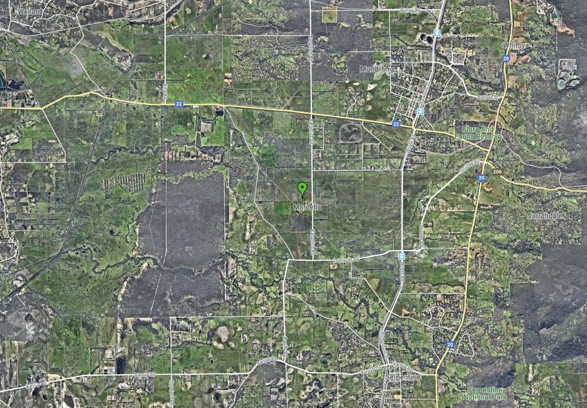
5.4 The Area Response Map – Awareness and Readiness Zones
Area Response Map (ARM)
The Area Response Map is located within Appendix 7.4. It is recommended that this map be located in a position
that is easily accessible from within the nominated emergency assembly building or area. The Map should be
accompanied by the Site Response Map, Emergency Contacts and Property Preparation Procedures. These
documents shall be laminated and water proof.
The Map is produced for the purposes of enabling the Bushfire Awareness Zone to be easily identified. The
map should be used to locate and monitor a bushfire, as well as identifying evacuation routes in readiness for
possible evacuation (refer to Section 6.3).
Bushfire Awareness Zone (BAZ)
The Awareness Zone is included on the Area Response Map. The purpose of this zone is to indicate a suitable
area surrounding the subject property within which to be:
1. Aware of the existence and the location and direction of travel of a bushfire; and
2. Where a bushfire is present, confirming that the required preparation has been conducted in advance
and continually monitoring the situation; and
3. Undertaking the required actions / tasks which are set out in Section 6.7.
Evacuation Readiness Zone (ERZ)
The Evacuation Readiness Zone is included on the Area Response Map. The ERZ indicates a suitable area
surrounding the subject property within which:
1. Where a bushfire is present, consideration must be given to whether evacuation can proceed safely;
and
2. Commence evacuation; and
3. Undertaking the required actions / tasks which are set out in Section 6.8.
Ordinary Council Meeting 15 April 2019 8Attachment 10.1.3.5
5.5 Fire Danger Rating (FDR)
Prior to a bushfire starting, the Fire Danger Ratings can provide indicative advice about the level of bushfire
threat on a particular day and how difficult and dangerous conditions will be if a fire starts. FDRs are based on
weather conditions forecast by the Bureau of Meteorology (BOM) or Emergency WA.
“If you are in a bushfire risk area you need to know what the Fire Danger Rating (FDR) is for your area, monitor
local conditions and keep informed.
Understanding the FDR categories and what they mean to you will help you to make decisions about what to
do if a bushfire starts.
The FDR is based on the forecast weather conditions and gives you advice about the level of bushfire threat on
a particular day. When the rating is high, the threat of a bushfire increases.
When the FDR is Extreme or Catastrophic for your area, it means any fires that start are likely to be so fierce
that even a well prepared, well-constructed and actively defended home may not survive a fire.
If this sort of weather is expected, you should leave the day or hours before a fire might threaten as this is the
best option for your survival” (Source: DFES 2017).
Refer to Figure 2 on the following page for further details about what the FDR categories mean and actions to
take.
The FDR can be easily checked via the Department of Fire and Emergency (DFES) or Bureau of Meteorology
(BOM) websites. Links are included below:
www.emergency.wa.gov.au/#firedangerratings
www.dfes.wa.gov.au/safetyinformation/fire/bushfire/Pages/firedangerratings.aspx
http://www.bom.gov.au/wa/forecasts/map.shtml - click on the relevant section of the map
Figure 1: Fire Danger Rating (FDR) Graphic (Source: DFES 2017)
Ordinary Council Meeting 15 April 2019 9Attachment 10.1.3.5
Figure 2: Fire Behaviour and Potential Impact (Source: DFES 2017)
5.6 Bushfire Warning System
During a bushfire, DFES and the Department of Parks and Wildlife issue community alerts and warnings for
bushfires that threaten lives and property. They are only issued once firefighters have arrived at the scene and
determined that there is a threat or potential threat to the community (Source: DFES 2017).
Ordinary Council Meeting 15 April 2019 10Attachment 10.1.3.5
Figure 3: Bushfire Warning System (Source: DFES 2017)
Continually monitor the DFES website for emergency alerts, warnings and updates. The link is
https://www.emergency.wa.gov.au/
Other sources of information include:
· DFES Emergency Information Line 13 3337 or 13 DFES
· DFES Alerts on ABC local radio
· DFES Emergency Telephone Alerts: All landline and mobile telephone numbers (including silent
numbers) are automatically registered to receive warning messages based on their billing address.
· Following DFES on Twitter at www.twitter.com/dfes_wa
If a life-threatening emergency always call triple zero (000)
Further details on the DFES Bushfire Warning System Alert Levels are presented in Figure 4 below.
Ordinary Council Meeting 15 April 2019 11Attachment 10.1.3.5
Figure 4: Bushfire Warning Levels (Source: DFES 2017)
Ordinary Council Meeting 15 April 2019 12Attachment 10.1.3.5
5.7 Procedures for Preparation of the Site
Part 1 – Awareness of Information – At all times
Responsible Preparation Procedure Completed
Person
Evacuation Plan Information
It is recommended that Site Response Map, Area Response Map, Property Preparation
Procedures and Emergency Contacts are all displayed in an obvious and accessible
location within the nominated emergency assembly building and the primary
reception/office on the property (if it is different).
Local Radio (ABC Station)
Tune in regularly for relevant bushfire information, as well as weather forecasts,
bushfire/weather warnings and locations of any current bushfires within the area.
Bureau of Meteorology (BOM)
Check the website regularly for information on weather conditions and trends, as well
as fire danger ratings.
Department of Fire and Emergency Services (DFES)
Check the website on a regular basis for fire danger ratings, bushfire locations /
movement, warnings and instructions. Undertake any early preparation for sheltering
in place.
Mobile phone devices
Keep charged and in good working order. Monitor for emergency alerts (text
messages).
Part 2 – Early Preparation - Prior to a Bushfire
Responsible Preparation Procedure Completed
Person
Buildings
Ensure any LPG gas cylinders have the pressure relief valve pointing away from
structures with a gap of six (6) metres from any fuel sources.!
Evacuation Vehicles
Check that all occupants have access to their own vehicles. In particular, ensure any
occupants under the age of 18 years are accounted for and have access to a safe mode
of transportation in the event of evacuation.
Equipment for Evacuation
Ensure any equipment required to evacuate occupants with a disability is easily
accessible & in good working order (e.g. wheelchairs).
Part 3 - Bushfire Current Within the Awareness Zone
Responsible Preparation Procedure Completed
Person
Evacuation Vehicles
Site Manager to organise roll call of all staff, occupants and other persons onsite – use
Onsite Occupant Log in Appendix 7.1.
Advise all occupants of potential requirement to evacuate site using their private
vehicles (if safe).
High Risk – Hazards on site
Relocation of staff and occupants in any log processing or storage buildings to
nominated Emergency Assembly Building, if it is safe to do so.
Part 4 – Sheltering in Place
Responsible Preparation Procedure Completed
Person
Be prepared to isolate electricity to the building if required.
Any small combustible items from around the building in which sheltering will take
place should be removed.
Any flammable furniture, fixtures or window treatments (curtains) should be moved
well clear of windows & door openings.
Ordinary Council Meeting 15 April 2019 13Attachment 10.1.3.5
6.0 Action Required - Bushfire Response
6.1 Safety Objective for Saw Mill
Watch and Act. Be Prepared to Leave Before Dangerous Conditions Exist.
The proposed Saw Mill located at 1548 Kargotich Road, Mardella meets the definition of a High Risk Land Use
in accordance with Policy Measure 6.6 of State Planning Policy 3.7. If the site is subject to a bushfire occurrence,
the priority must be to evacuate all persons at the earliest time possible. Evacuation should only be undertaken
if it can be achieved safely.
6.2 Early Evacuation – Persons with Special Needs
Occupants and staff with special needs such as asthma or respiratory conditions need to be identified for
early evacuation should the air quality become affected by smoke.
People with asthma and pre-existing respiratory, cardiovascular illnesses or diabetes should follow their pre-
prepared treatment plan.
People with conditions exacerbated by smoke should take precautions in line with their medical advice for
these circumstances.
6.3 Safe Evacuation Route Options
The suitability of evacuation routes will vary depending on road conditions which could be normal, or
disrupted and blocked. It is, therefore, important to have an alternative route planned.
Northern Evacuation Routes
North along Kargotich Road to Mundijong Road and then East or West depending on fire location and
evacuation centre location.
Note: From Kargotich Road and Randell Road Crossroad, travel is also available in an easterly direction along
Randell Road to Wright Road.
Southern Evacuation Routes
South along Kargotich Road to Lowlands Road and then East or West depending on fire location and
evacuation centre location.
Ordinary Council Meeting 15 April 2019 14Attachment 10.1.3.5
6.4 No Bushfire Known - Forecast ‘Severe’, ‘Extreme’ or ‘Catastrophic’
Fire Danger Rating is ‘Severe’, ‘Extreme’ or Catastrophic’ as forecast by the Bureau of Meteorology (BOM).
The following action should be taken:
· Prepare the property as set out in Section 5.7 preferably the day before or not later than that
morning; and
· Consider total Evacuation / Relocation of all non-essential staff from the property the day before; and
· Consider evacuating remaining staff by 9 am on the day. It is important to evacuate early, hours
before a bushfire starts. Do not wait and see.
6.5 No Bushfire Known - FDR Forecast ‘Very High’
The Bureau of Meteorology forecast Fire Danger Rating is ‘Very High’.
The following action should be taken:
· Prepare the property as set out in Section 5.7 preferably the day before or not later than that
morning; and
· Designated staff to monitor the Bushfire Awareness Zone (BAZ) for bushfires throughout the day and
evening; and
· Monitoring shall entail of checking websites, listening to the radio and observing for signs of smoke on
the horizon regularly but at least three times daily (e.g. morning, midday and afternoon).
6.6 No Bushfire Known - FDR Forecast ‘High’ or ‘Low’
The Bureau of Meteorology forecast Fire Danger Rating is ‘High’ or ‘Low’.
The following action should be taken:
· Site operates as normal; and
· Monitor the Bushfire Awareness Zone (BAZ) for indications of a bushfire event.
6.7 Bushfire Present within the Bushfire Awareness Zone (BAZ)
A bushfire has been identified within the Bushfire Awareness Zone (BAZ), but no bushfire exists within the
Evacuation Readiness Zone (ERZ).
The following action should be taken (refer to Section 5.7):
· Enact ‘Property Preparation Part 1 – Information Awareness’ (Section 5.7)
· Confirm or Conduct ‘Property Preparation Part 2 - Before a Bushfire Event’ (Section 5.7)
· Conduct ‘Property Preparation Part 3 – Bushfire Present within Awareness Zone – Evacuation Vehicles
(Section 5.7)
· Nominated staff or occupants should, to the best extent possible, locate the bushfire on the Area
Response Map and identify the direction of the fire movement (consider local wind direction and any
information from the emergency services). Be aware there may be several bushfires. (Note: If the
bushfire location is unable to be determined with reasonable accuracy, assume the worst and prepare
to evacuate)
Ordinary Council Meeting 15 April 2019 15Attachment 10.1.3.5
· Nominated staff must identify the appropriate evacuation route to use should the decision be made
to evacuate (and an alternative if available). The safest evacuation routes are set out in Section 6.3
and on the Area Response Map, in 7.4 of the Appendices.
· Monitor the situation, keep informed.
The following action should be taken when making a decision to evacuate:
· Be aware of your ongoing ability to evacuate safely and base the decision to evacuate on this ability or
any emergency services directives received.
· If the fire is moving towards your required evacuation route, then evacuate now if you can execute it
safely.
· If you cannot evacuate safely prepare to shelter in place (refer Section 6.9)
6.8 Bushfire Present within the Evacuation Readiness Zone (ERZ)
The following action should be taken when a bushfire has been identified within the Evacuation Readiness
Zone:
· Take shelter within the nominated Emergency Assembly Building. This building is identified on the
Site Response Map in Appendix 7.5.
· Emergency Assembly Building: Staff Building
· Continue or Enact ‘Property Preparation Part 1 – Information Awareness’ (Section 5.7)
· Confirm or Conduct ‘Property Preparation Part 3 – Bushfire Present within Awareness Zone –
Evacuation Vehicles (Section 5.7)
· Identify the safest evacuation route to use and an alternative if available (Section 6.3)
· Evacuate - If the Evacuation Routes are deemed to not be safe, then SHELTERING-IN-PLACE will be the
required action. Follow the procedures in Section 6.9
6.9 Procedures for Sheltering in Place
The following action should be taken where evacuation is not possible and sheltering in place is required:
· Take shelter within the nominated Emergency Assembly Building. This building identified on the Site
Response Map in Appendix 7.5.
· Emergency Assembly Building: Staff Building
· Conduct ‘Property Preparation Part 4 – Shelter in Place’ (Section 5.7)
Immediately notify DFES (phone 000) - Provide the following details:
1. Nature of the incident and state that people are sheltering in place;
2. Location (street address);
3. Nearest cross roads (names and distance);
4. Where sheltering;
5. Entry point to shelter – identifying markers;
6. Number of people sheltering;
7. Number of special needs persons;
8. Can you see the fire front /estimate distance away; and
9. Can you see spot fires / are spot fires around the shelter.
Ordinary Council Meeting 15 April 2019 16Attachment 10.1.3.5
If the nominated Emergency Assembly Building is deemed unsafe or to be under direct threat, staff must
evaluate the situation and make informed decisions. The choice will be to continue to stay and defend or
proceed to an area of minimal fuel vegetation as a last resort and if it is safe to do so. The latter action is not
recommended, but is an alternative if the current refuge is deemed to be not safe for occupants and vehicle
evacuation routes are involved with or under direct threat from the bushfire.
6.10 Return Procedures Post Evacuation
The return of evacuees should be a planned and managed process in consultation with relevant authorities.
This is to ensure the safety, welfare and ongoing support needs of the community are met.
Ordinary Council Meeting 15 April 2019 17Attachment 10.1.3.5
7.0 Appendices – Additional Information and Maps
7.1 Onsite Occupant Log
Note: Photocopy as many as required (Sheet ___ / ___)
Name of Person Person Responsible for Building/ Contact Any Person
(Staff, visitors,
Visitor/Contractor/Occupant Location on Mobile No. Special Accounted
contractors and all
other occupants) (where applicable) site (onsite use) Needs For
Ordinary Council Meeting 15 April 2019 18Attachment 10.1.3.5
7.2 Community Member Contact Details
Person
Responsible for Contact
Name of Emergency Contact Person
Community Member Contacting Mobile
Person Number Contacted
Community No.
Member
Ordinary Council Meeting 15 April 2019 19Attachment 10.1.3.5
7.3 Guidelines for Sheltering in Vehicle
It is recommended a copy of the following information is provided to occupants of the Saw Mill facility during
the bushfire season.
KEEP A COPY IN GLOVE BOX
Many fatalities have occurred when people have been caught on the road, either on foot or in vehicles.
Sheltering inside a vehicle offers a slightly higher chance of survival than being caught in the open, evacuating
early is the preferred and safest option. Sheltering inside a car is a high risk activity.
Encountering smoke or flames:
· If smoke is in the distance or can be smelt, find another way and drive away.
· If confronted with smoke or flames on the road, stop as soon as it is safe, turn on headlights and
hazard lights. Continuing to drive through thick smoke and flames is risky, do not park on the road.
· Whenever possible (and safe to do so) driving away from danger is preferable.
· If the fire front is too close the preferred option may be to look for a safe place to park.
· Try and establish communications with authorities through phoning 000 and let them know of your
situation and location.
Positioning the vehicle:
· Park away from fine fuels, (bush, grass, overhanging branches, etc.).
· A non-combustible surface is best.
· Don’t park to close to other vehicles.
Stay inside your vehicle:
· Do not get out, your vehicle offers the best level of protection from radiant heat.
· Turn all lights on, tightly close all windows and doors & Leave engine running.
· Place vehicle ventilation on re-circulation and leave air conditioning on.
· Get down below window level into the foot wells and shelter under woollen blankets.
As the fire front passes:
· Stay in the vehicle until the fire front has passed and the outside temperature has dropped. You will
need to exit the vehicle as early as possible as it may be on fire.
· Once the fire front has passed cautiously exit the vehicle, move to a safe area such as a strip of land
already burnt or rocky outcrop.
· Stay covered in blankets, keep drinking and contact authorities if possible.
Ordinary Council Meeting 15 April 2019 207.4 - Area Response Map Fire Protection Association Australia Life Property Environment Attachment 10.1.3.5
Nearest Evacuation Centre
Listen to DFES Emergency
Broadcast on ABC Radio
Contact Phone
Emergency 000
DFES 13 33 37
Northerly
Evacuation Route
via Kargotich Road
Southerly ADDRESS:
Evacuation Route 1548 Kargotich Road,
via Kargotich Road Mardella 6125
LEGEND
Evacuation Readiness
Zone (2.5km radius)
Bushfire Awareness
Zone (5km radius)
Subject Land
0m 1500m 3000m
Ordinary Council Meeting 15 April 20197.5 - Site Response Map Fire Protection Association Australia Life Property Environment Attachment 10.1.3.5
Nearest Evacuation Centre
Listen to DFES Emergency
Broadcast on ABC Radio
EMERGENCY
Contact Phone
ASSEMBLY Emergency 000
POINT DFES 13 33 37
Car Park
Truck turning
area Truck Weigh Bridge
ADDRESS:
1548 Kargotich Road,
Mardella 6125
LEGEND
Subject land
Proposed
0m 120m 240m
Scale 1:4863 at A3
Map Source: WALGA Environmental Planning Tool 2018 Ordinary Council Meeting 15 April 2019Attachment 10.1.3.5
Applicant Declaration:
I declare that the information provided is true and correct to the best of my knowledge.
John Greenwood
MSc (Curtin) BAppSc (Building Surveying) MAIBS, MAIB
Level 1 Building Sur veyor BPAD36633 (Level 2)
WABAL & WA BCA Group
Address Suite 14 755 Albany Highway East Victor ia Park
Tel +61 8 9355 5484 | Email | Website | Submit
Ordinary Council Meeting 15 April 2019 23You can also read