Penrose Conference Beyond the Plume Hypothesis Testing the plume paradigm and alternatives Plume IV: The Fieldtrip Handbook - MantlePlumes
←
→
Page content transcription
If your browser does not render page correctly, please read the page content below
Penrose Conference
         Plume IV:
Beyond the Plume Hypothesis
Testing the plume paradigm and alternatives

    The Fieldtrip Handbook

  August 30th – September 2nd, 2003
               Iceland

       http://www.mantleplumes.org/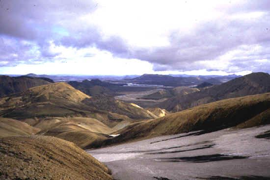
1

List of Participants                      Prof. Warren Hamilton
                                          Dept. of Geophysics,
Prof. Francoise Chalot-Prat               Colorado School of Mines,
CNRS/CRPG                                 Golden CO 80401, USA
Nancy University, BP20,                   tel: 303 384 2047
15 rue Notre Dame des Pauvres             fax: 303 273 3478
F-54501 Vandoeuvre les Nancy, France      whamilto@mines.edu
tel: 33 (0)3 83 59 42 48
fax: 33 (0)3 83 51 17 98                  Dr. Gregory Huffman
chalot@crpg.cnrs-nancy.fr                 Department of Earth Sciences,
                                          Laurentian University,
Prof. Richard Chamberlin                  935 Ramsey Lake Road,
New Mexico Bureau of Geology & Mineral    Sudbury, Ontario, Canada, P3E 2X2
Resources                                 tel: (705) 671-3418
801 Leroy Place, Socorro, NM 87801-4769   gw_huffman@nickel.laurentian.ca
tel: 505/835-5310
fax: 505/835-6333                         Dr. S. P. Jakobsson
richard@gis.nmt.edu                       Icelandic Institute of Natural History
                                          Hlemmur 3, IS-105 Reykjavik, Iceland
Prof. Bob Christiansen                    tel:+354-590-0500
U.S. Geological Survey                    fax:+354-590-0595
345 Middlefield Rd., MS 910               sjak@ni.is
Menlo Park, CA 94025, USA
tel: 650 329 5201                         Prof. Bruce Julian
fax: 650 329 5203                         U.S. Geological Survey
rchris@usgs.gov                           345 Middlefield Rd., MS 977
                                          Menlo Park, CA 94025, USA
Prof. Wolfgang Elston                     tel: 650 329 4797
Dept Earth and Planetary Sciences         fax: 650 329 5163
University of New Mexico                  julian@usgs.gov
Albuquerque, NM 87131-1116
home: (505) 255-9170                      Prof. Jose Mangas
work: (505) 277-5339                      Departamento de Física.
fax: (505) 277-8843                       Facultad de Ciencias del mar.
weelston@earthlink.net                    Universidad de las Palmas de Gran Canaria
                                          Edificio de Ciencias Básicas.
Dr. Gillian R. Foulger                    Campus de Tafira. 35017
University of Durham,                     Las Palmas de Gran Canaria. Spain
Dept. Geological Sciences,                tel: (34)928451296
Science Laboratories,                     jmangas@dfis.ulpgc.es
South Rd., Durham DH1 3LE, U.K.
g.r.foulger@durham.ac.uk                  Prof. Angelo Peccerillo
                                          University of Perugia,
                                          Dipartimento di Scienze della Terra,
                                          Piazza Università 1,
                                          06100 Perugia, Italy
                                          tel: (+39) 0755852608
                                          pecceang@unipg.it
2

                                               Prof. Carol Stein
Prof. Emma Perez-Chacon                        Dept. of Earth & Environmental Sciences
Universidad de Las Palmas de Gran Canaria,     (m/c 186), University of Illinois at Chicago
Departamento de Geografía. Campus              845 W. Taylor Street
Universitario del Obelisco.                    Chicago, IL 60607-7059, USA
C/Pérez del Toro, nº1,                         tel: 312-996-9349
35003 Las Palmas de G.C., Spain                fax: 312-413-2279
tel: 928-442774                                cstein@uic.edu
eperez@dgeo.ulpgc.es
                                               Prof. Seth Stein
Dr. Brian Pope                                 Department of Geological Sciences
Saint Louis University                         Northwestern University,
3507 Laclede Ave                               Evanston, IL 60208, USA
St. Louis, MO 63103, USA                       tel: (847) 491-5265
tel: (314)307-0650                             fax: (847) 491-8060
popebj@slu.edu                                 seth@earth.northwestern.edu

Prof. Hetu Sheth                               Prof. Phil Wannamaker
Department of Earth Sciences,                  Univ. Utah/EGI
Indian Institute of Technology (IIT) Bombay,   423 Wakara Way, Suite 300
Powai, Bombay 400 076, India                   Salt Lake City, UT 84108, USA
tel: 91-22-25767264 (office)                   tel: 801 581 3547
tel: 91-22-25767251/7251 (switchboard)         pewanna@egi.utah.edu
fax: 91-22-25767253
fax: 91-22-25723480 (IITB main)                Prof. Don Wright
hcsheth@iitb.ac.in                             Department of Earth Sciences
                                               Room ER4063, Alexander Murray Building
                                               Memorial University of Newfoundland
                                               St. John's, NL, Canada, A1B 3X5
                                               tel: (709) 754-8760 (home)
                                               tel: (709) 737-8142 (work)
                                               n12dmw@mun.ca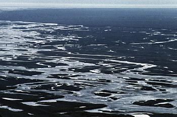
3

                                  SOUTH ICELAND FIELDTRIP

Note: The detailed itinerary may alter if required by local conditions at the time.

Leaders: Sveinn P. Jakobsson & Gillian R. Foulger

DAY 1: Saturday 30th August, 2003

Fly to Heimaey, the largest of the Westmann Islands. Geology of Heimaey and the 1973 eruption
products of Eldfell. Fly back at 6 pm.

Dinner and overnight at Leirubakki

The 1973 eruption of Eldfell on Heimaey

One of the most destructive volcanic eruptions in the history of Iceland began in the early morning of
January 23, 1973, near Iceland's premier fishing port, Vestmannaeyjar, on Heimaey. The eruption was
the second definite major eruption (the other being Surtsey) to have occurred in the area since the
settlement of Iceland in the ninth century.

                                          The island of Heimaey
4
The 1973 eruption began just before 1 a.m., January 23, on the eastern side of Heimaey, approximately
1,100 m from the center of town. A north-northeast trending fissure rapidly opened to a length of about
2 km, traversing the island from one shore to the other. Spectacular continuous lava fountains played in
the initial phase of the eruption, but the activity soon consolidated to a small area along the fissure
about a kilometer northeast of Helgafell. Also during the first 3 days, submarine volcanic activity
occurred just offshore at the north and south ends of the fissure vent. Within 2 days a cinder-spatter
cone rose more than 110 m above sea level and was named Eldfell or "fire mountain". The output of
lava and tephra was ~ 130 m3/s.
Eruption of Eldfell
Within a few days after the eruption, strong easterly winds resulted in a major fall of tephra on the
town, completely burying homes close to Eldfell. By early February the tephra fall slackened markedly,
but a massive lava flow approached the eastern edge of the town and threatened to fill in the harbor of
this, Iceland's most important fishing port. A dramatic effort to combat this threat was made, by
pumping sea water onto the lava to chill and stop its front. First the pumps and hoses that were to hand
were used, but when this proved insufficient the US sent a dredging vessel with very large-gauge hoses
and enormous pumps. This effort had much more effect and was probably responsible for the survival
of the port.
By the end of February the cinder-spatter cone was more than 200 m high. The central crater of Eldfell
fed an aa lava flow which moved relentlessly toward the north, northeast, and east. By early May this
flow was 10 to 23 m high at its front, averaged more than 40 m thick, and was as much as 110 m thick
in places. Its upper surface was littered with scoria and volcanic bombs, as well as large blocks from
the main cone which broke off and were carried along with the flow. The largest block was dubbed5 “Flakkarinn” (lit. “The Wanderer”). Some of these blocks of welded scoria were about 200 m2 in area, stood 20 m above the general lava surface and were rafted more than 1,000 m. Measurements made from a series of aerial photographs taken from the end of March to the end of April indicated that the lava was flowing as a unit about 1,000 m long by 1,000 m wide with an average speed of 3 to 9 m per day. The total volume of lava and tephra was about 0.25 km3 which is relatively small on an Icelandic scale. The eruption stopped in early July 1973. Flowing lava was no longer visible, although hidden subsurface flow may have continued for a while. About 300 million m3 of tephra were deposited on and adjacent to Heimaey. Within 6 hours after the eruption began, nearly all of Heimaey's 5,300 residents had been evacuated safely to the mainland. Homes and farmsteads close to the rift were soon destroyed by tephra burial or fire from lava bombs and flows. The heavy tephra fall caused severe property damage a few days after the onset of the eruption. Numerous homes were completely buried by tephra, set on fire by glowing lava bombs, or overridden by the advancing front of lava flows. Although many structures collapsed from the weight of the tephra, dozens were saved by crews of volunteers who cleared the roofs of accumulated tephra and tacked corrugated iron over the windows. By early May, some 300 buildings had been engulfed by lava flows or gutted by fire, and another 60 to 70 homes had been buried completely by tephra. DAY 2: Sunday 31st August, 2003 Thjorsardalur – Stöng – Burfell – Hafid – Seljalandsfoss – Eyjafjöll – Skogafoss – Hvammsmuli Skogasandur – Dyrhólaey – Vik Dinner and overnight at Vik in Myrdalur. Thjorsardalur Some early settlers chose the fertile valley of Thjorsardalur for their farmsteads. They were unaware of the fact that the tranquil-looking, snow-capped mountain towering on the south was an active volcano. In 1104, there was a massive eruption in Mt. Hekla, and the settlement in Thjorsardalur was buried under volcanic debris and ash. In 1939 Scandinavian archaeologists excavated the buried farmhouse at Stöng and uncovered the Saga- age farm. The findings provided fresh data about the design and construction of Viking long-houses and their evolution up to the 12th century and other valuable information about the period known as the Commonwealth. In 1974, on the 1100th anniversary of the settlement of Iceland, architect Hördur Águstsson and a team of historians meticulously constructed a replica of Stöng at Skeljastadir, a few kilometers down the valley. The reconstructed farm is called Thjodveldisbaer (lit. “Commonwealth Farm”), and is perhaps the best representation of an Icelandic medieval dwelling. What is actually left of the original farm at Stöng are some stone foundations, now covered by a large protective wooden shelter.
6

Stöng is also known for being the home of the famous farmer/warrior Gaukur Trandilsson who,
according to a brief account in Njal's Saga, was killed by Ásgrimur Ellida-Grimsson, his foster-brother,
in a duel of honour over Gaukur's affair with a kinswoman of Grimsson. In the 19th century some old
bones were discovered in a steep cliff on the north bank of Thjorsá river, further down the valley, and
were supposed to be those of Gaukur from Stöng. The place is called Gaukshofdi (lit. “Gaukur's
bluff”).

                                                  Stong

Burfell

Burfell power station is at the head of Thjorsárdalur valley in south Iceland. The Burfell development
consists of a dam on the river Thjorsá which previously flowed south of Mt. Burfell, diverting it
northwards through the Samsstadamúli ridge and into the Thjorsárdalur valley. A dam 4 km above the
station diverts the river Thjorsá to the west through an ice barrier running at right angles from north of
the dam to the west bank of the river. A channel containing a sluice runs to the west and into a cirque
where the water collects in a 1 km2 reservoir, Bjarnalon.

The water is channeled from the western edge of the reservoir to the intake of a tunnel that has been
blasted through Sámsstadamúli ridge. Measuring 1 km in length and 10 m in diameter, the tunnel lies
more or less horizontally and is largely unclad. The intake tunnel divides into two concrete-clad
pressure shafts 5.5 – 6 m in diameter which create a vertical drop of 100 m. A 200 m horizontal
headrace then leads up to the powerhouse. It is clad with steel along its final 100 m stretch and
branches out to feed six turbines, each with a 45 MW capacity. After driving the turbines in the
powerhouse the water enters a short channel feeding the River Fossá in Thjorsárdalur, which joins the
River Thjorsá 2 km downstream.
7
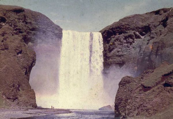
Skogafoss
Skogafoss waterfall
DAY 3: Monday 1st September, 2003
Vik – Hjörleifshofdi – Skaftartunga – Laki – Landbrot – Sida – Skeidararsandur – Skaftafell –
Breidamerkurlon – Sandfell – Hunkubakkar.
Dinner and overnight at Hunkubakkar.
Dyrholaey
Dyrholaey is a 120 m high precipitous promontory. A large, natural
gate has eroded through its southernmost part. When the sea is
calm, large vessels can sail through it and in 1995, two adventurers
flew in a small aircraft through it. The view from the highest points
of the promontory, where the 1927 lighthouse stands, is excellent
on a fine day. In earlier times fishing outfits were operated from the
lower parts of the promontory and harbour construction has been
considered. South of the promontory are freestanding cliffs in the
ocean, one of which resembles a petrified elephant. It is interesting8
to watch the bird life in the cliffs, especially puffins.
Hjörleifshofdi
Hjörleifshofdi is a freestanding, 221 m high hyaloclastite promontory on the outwash plain
Myrdalssandur. According to Book of Settlements, a bay reached the foothills of this low mountain at
that time, but was filled up with sediment from glacial bursts caused by Katla eruptions. Now the
distance between the promontory and the sea is about 2 km.
In 874, two foster brothers, Ingolfur and Hjorleifur, traveled to Iceland with their households to settle
permanently. Their ships were separated in a storm and each household spent the winter on separate
promontories, which were consequently named after these men. The first farms stood just west of the
promontory until 1721 when an eruption of the Katla caused a devastating flood which swept away the
houses and the green pastures and meadows. After that, the farms stood on the promontory itself. The
last one was abandoned just before the middle of the 20th century. Up to the same time, men were
roped down the precipices to collect fulmar chicks, which were part of the diet at the time and still are
among people who stick to the old traditions.
Öraefajokull
Öraefajokull is the highest mountain of Iceland at 2,119 m,
and stretches to the edge of the ice cap Vatnajokull. The
terrain to its south rises to about 100 m above sea level. The
mountain is a topless stratovolcano with a large, ice filled
caldera. Its ice cover reaches down to 1,800 m elevation and
usually a few precipitous cliffs remain ice-free. It is the
second most active stratovolcano in Europe, after Mt. Etna in
Sicily. The base diameter of the mountain is about 20 km and
its ground area about 400 km2. Its volume is ~ 370 km3. Prior
to the enormous eruption in 1362 its name was Knappafell.
The name of the inhabited area between the alluvial plains Skeidararsandur in the west and
Breidamerkursandur in the east, Oraefi, dates to the aftermath of the first eruption in historic times.
That eruption almost totally destroyed the area and killed most of the inhabitants and their livestock.
Afterwards the area looked like a vast desert, which is what the word Oraefi means. The rhyolite peak
Hvannadalshjukur rises 300 m above the caldera, which is 5 km long and has an area of 12 km2. The
average snow thickness added to the area annually is about 10 m, and the average precipitation there
exceeds all other parts of Iceland. A number of small glacier tongues slowly crawl down the indented
slopes of the mountain from about 1,800 m elevation.
The volcano has erupted twice in historical times, in 1362 and 1727. The first eruption was the largest
pumice eruption in historical times in the country. The volume of the tephra was ~ 10 km3, which
corresponds to about 2.5 km3 of compact rhyolite. The immense flood waves following the eruption
swept most of the farms away in the Little District, as the area was called prior to the eruption. In the
north, and off the northwest coast, ash fell and boats had difficulty getting through thick, floating
patches of pumice on the sea. Thick patches of pumice from this eruption are presently all over the
Oraefi area.9
The second eruption started in January 1727 and lasted almost a year. Its fury was greatest during the
first three days and the ash fall so great that it was impossible to distinguish night from day. Fewer
people and livestock were killed and no farms were destroyed because they stood on much higher
ground than before. The volume of tephra emitted was also much less than during the first eruption.
The main flood wave ran eastwards past the parsonage at Sandfell and the farm Hof. Signs of this
natural catastrophe are still clearly visible in the area.
Skeidararsandur
West of Öraefajokull is the vast
sand plain of Skeidararsandur, onto
which glacial bursts
(“jokullhlaups”) from the southern
edge of Vatnajokull have flowed
ever since the country-wide icecap
receded at ~ 10,000 BP. Glacial
bursts occur regularly here because
the caldera lake of the subglacial
volcano Grimsvotn regularly fills
with geothermal meltwater, empties
under the glacier, and flows south
to drain into the sea.
Skeidararsandur was the site of an
exceptionally violent glacial burst
in 1996 following the Gjalp
subglacial eruption. This burst was exceptionally large and rapid because on this occasion the caldera
lake had been filled with warm water from the eruption and thus it melted additional ice on its journey
south beneath the icecap, and a large channel for itself, enabling the caldera lake to empty much more
quickly than usual.
DAY 4: Tuesday 2nd September, 2003
Eldgja – Kirkjufell – Landmannalaugar – Blahnukur – Namshraun – Ljotipollur – Domadalshraun –
Valagja (Hekla).
Dinner and overnight in Reykjavik.
Eldgjá
The Eldgjá (lit. “Fire Fissure”) fissure is part of the Katla volcanic system. The Eldgjá eruption
occurred about 934 AD, partly subglacially and partly subaerially, on a 75 km long fissure extending
from Katla in the southwest, to the edge of Vatnajokull. Its major product was a 700 km2 basaltic lava
field with an estimated volume of ~ 10 km3 and a widespread basaltic tephra layer. The eruption was
dated by tephrochronology to the early 10th century.10 The 150 m deep, 400 m wide, 8 km long Eldgjá fissure proper is a complex volcano-tectonic structure and the most spectacular part of the whole fissure. It is a graben, an eruptive fissure and an explosive crater row. The scarps inside Eldgjá expose outcrops of basaltic hyaloclastites, tillite and breccias, overlain by the recent volcanic products of the Eldgjá eruption. The top layer is a 10 to 15 m thick agglutinate, composed of partly welded spatter from fire fountaining activity in the fissure. Short rows of spatter cones from the last phase of the eruption decorate the floor. It is most likely that the Eldgjá eruption is a result of a crustal rifting episode and lateral magma flow from Katla. The chemistry of Katla and Eldgjá magmas is similar, characterized by transitional to alkali basaltic magmas with unusually high titania. A shallow crustal magma chamber below Katla has recently been proposed on the basis of seismic studies. The largest historic eruption on Earth occurred from the 27 km long Lakagigur fissure between June 1783 and February 1784. 14 km3 of lava were erupted and flowed into the Skaftá river valley. This caused one of the greatest disasters ever to befall the Icelandic nation, as flouride that degassed poisoned the grass over a large area leading to the death of much livestock and starvation of 1/3 of the human population that winter. Another 1/3 of the population emigrated to Canada in desperation, reducing the population of Iceland to only a few tens of thousands of souls.
11

Landmannalaugar

                                             Landmannalaugar (lit. “Pools of the people of the Land
                                             district”) is a natural hot spring bathing area within the
                                             Torfajökull volcano, the site of the greatest concentration
                                             of rhyolitic lava in Iceland, and indeed anywhere on the
                                             oceanic spreading plate boundary. It is reached by the
                                             rugged Fjallabak road (lit. “Mountain Back”). The area is
                                             a nature reserve.

                                             The Torfajökull central volcano is active, but is in a
                                             declining fumarolic stage. The hot pools at
                                             Landmannalaugar are but one of many geothermal
manifestations which alter the minerals in the rocks, causing remarkable color variations. The volcano
has been most productive during the last 2 million years. Sub-glacial rhyolites are characteristic
formations in the area. North of Torfajökull sub-glacial volcanic activity produced hyaloclastite
mountains.

Volcanic activity in Recent times has been restricted to a few northeast – southwest fissures. The most
recent eruption, from the Veidivötn fissure in 1480, formed the lava Laugahraun which can be seen by
the mountain hut at Landmannalaugar. Further to the north, eruptions have been explosive and occur
every 500 – 800 years. Known eruptions occurred around AD 150 and 900.

Hekla

Hekla is the most famous volcano in Iceland and one of the most active. This 1500-m-high volcano is
the one that has caused most damage in the past. Its oldest rocks, lava flows, are from the last
interglacial period. Numerous hyaloclastite flow units present in the close vicinity of the volcano are
from the last glacial period.

Holocene activity has been vigorous. Three major prehistoric eruptions are named Hekla 3, 4 and 5. In
those eruptions immense amounts of rhyolitic ash were produced. The ashes covered the central and
northern part of Iceland and can be found as distinct tephra layers in soil profiles.

The first historic eruption of Hekla occurred in the year 1104. It started as a violent Plinian eruption
and white-coloured ash was blown to the north-northwest. As a result of the eruption a few tens of
farms were permanently abandoned. No lava has been found that matches this eruption. Since 1104 the
volcano has erupted rather regularly, usually once or twice a century. Lavas have been identified from
most of the eruptions.

The magma production rate seems to have been steady, at least from about the year 1500, at about 1
km3 per century. Usually each eruption starts with a few hours of a violent Plinian phase producing
rhyolitic to andesitic pumice and ash. Andesitic lavas pour out after the initial explosive phase. Each
eruption usually last for a few months to a year. The longest eruption lasted two years (1766-68).

In the latter half of the last century there seems to have been a change in the eruption style of Hekla.
The volcano has erupted once every decade since 1970, but each eruption has lasted only for a few
12
months and the magma volumes have been relatively small. At Skjolkviar lava flows from the 1970
and 1980 eruptions can be inspected.
The chemistry of the magmas is intermediate – neither typical tholeiitic nor alkalic. Magmas from
Hekla itself are andesitic to rhyolitic in composition. Magmas erupted outside the volcano, but within
the Hekla volcanic system, tend to be basaltic.
Acknowledgement: Some of the text and figures were adapted or copied from the guidebook of Trönnes
et al. [2003]. GRF thanks R. Trönnes for kindly supplying an electronic version of this guidebook.
Historic eruptions in the Hekla volcanic system13 Some recent Hekla lava flows
14
You can also read