Phase 1 Heritage Impact Assessment of a proposed new industrial development on the farm Waterval 168, Sabie, Mpumalanga Province - Report ...
←
→
Page content transcription
If your browser does not render page correctly, please read the page content below
Phase 1 Heritage Impact Assessment of a proposed new
industrial development on the farm Waterval 168, Sabie,
                Mpumalanga Province.

                        Report prepared for:
                 Greenbox Environmental Consultants
                                 by
                        Paleo Field Services
                           PO Box 38806
                         Langenhovenpark
                               9330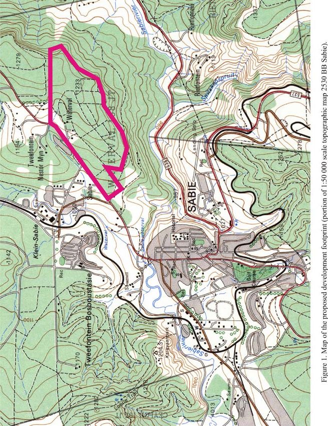
Summary
At the request of Greenbox Environmental Consultants a Phase 1 Heritage Impact
Assessment was carried out for a proposed new 170 ha industrial park development
on the farm Waterval 168, situated in Sabie, Mpumalanga Province. Sabie lies within
the outcrop area of the late Archaean Black Reef Formation, located within the basal
part of the Transvaal Supergroup. Superficial sediments within the study area are
made up of colluvium and unconsolidated residual soils. Outcrop visibility is
generally very poor given the intensive forestry development, while the site has also
been severely degraded by the tree-planting activities. There are no evident signs of in
situ Stone Age archaeological sites or scatters, prehistoric structures or historically
significant structures older than 60 years. A small informal graveyard (GPS
coordinates 25° 4'31.49"S, 30°48'13.15"E) with at least 10 graves and several
modern-built, but dilapidated dwellings were recorded during the survey. As far as the
overall palaeontological heritage is concerned, likelihood of palaeontological impact
resulting from this development is considered low, given the disturbed terrain and
lack of suitable fossil-bearing rock. However, it is recommended that should any
fossils be uncovered within intact sedimentary rocks during the development, a
suitably qualified palaeontologist must evaluate the finds or monitor the exposed
areas as soon as possible. It is evident that all potential aboveground or subsurface
archaeological remains will have been destroyed by the intensive forestation
activities. As far as the archaeological heritage is concerned, the proposed
development footprint is considered to be of low archaeological significance.
Provided that the graveyard is properly maintained, permanently fenced off and
protected by a 10 m no-go buffer zone during planned construction activities, the
development footprint is assigned a site rating of Generally Protected C.

                                                                                      2
Contents
Summary ........................................................................................................................ 2
Introduction .................................................................................................................... 4
Description of the Affected Area ................................................................................... 5
Background .................................................................................................................... 5
Field Assessment ........................................................................................................... 6
Impact Statement and Recommendation ....................................................................... 6
References ...................................................................................................................... 7
Tables and Figures ......................................................................................................... 9

                                                                                                                                 3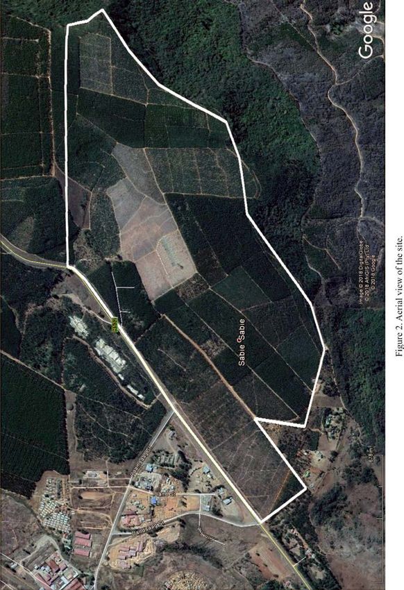
Introduction
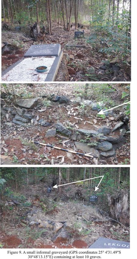
At the request of Greenbox Environmental Consultants a Phase 1 Heritage Impact
Assessment was carried out for a proposed new 170 ha industrial park development
on the farm Waterval 168, situated in Sabie, Mpumalanga Province (Fig. 1). South
Africa’s unique and non-renewable heritage is ‘Generally’ protected in terms of the
National Heritage Resources Act (Act No 25 of 1999) and may not be disturbed at all
without a permit from the relevant heritage resources authority. The NHRA requires
that all heritage resources, that is, all places or objects of aesthetic, architectural,
historical, scientific, social, spiritual, linguistic or technological value or significance
are protected. Thus any assessment should make provision for the protection of all
these heritage components, including archaeology older than 100 years, shipwrecks,
battlefields, graves, and structures over 60 years of age, living heritage and the
collection of oral histories, historical settlements, landscapes, geological sites,
palaeontological sites and objects. The Act identifies what is defined as a heritage
resource, the criteria for establishing its significance and lists specific activities for
which a heritage specialist study may be required. In this regard, categories of
development listed in Section 38 (1) of the NHR Act are:
• The construction of a road, wall, powerline, pipeline, canal or other similar
form of linear development or barrier exceeding 300m in length;
• The construction of a bridge or similar structure exceeding 50m in length;
• Any development or other activity which will change the character of the site;
• Exceeding 5000 m² in extent;
• Involving three or more existing erven or subdivisions thereof;
• Involving three or more subdivisions thereof which have been consolidated
within the past five years;
• Costs of which will exceed a sum set in terms of regulations by the South
African Heritage Resources Agency (SAHRA).
• The rezoning of a site exceeding 10 000 m².
• Any other category of development provided for in regulations by the South
African Heritage Resources Agency (SAHRA).
4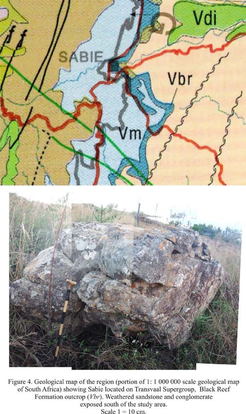
Methodology
The affected areas were evaluated on the basis of existing field data, database
information, maps and published literature.      This was followed up by a field
assessment (pedestrian survey of each locality). A Garmin Etrex Vista GPS hand
model (set to the WGS 84 map datum) and a digital camera were used for recording
purposes. Relevant heritage information, aerial photographs (Google Earth) and site
records were consulted and integrated with data acquired during the site visit. A site
visit was conducted over the weekend of 12 May 2018.
Terms of reference:
   •   Identify and map potential heritage sites and occurrences using available
       resources.

   •   Determine and assess the potential impacts of the proposed development on
       potential heritage resources;

   •   Recommend mitigation measures to minimize potential impacts associated
       with the proposed development.
Field Rating
Site significance classification standards, as prescribed by SAHRA, were used for the
purpose of this report (Table 1).

                           Description of the Affected Area
Locality data
1 : 50 000 scale topographic map 2530BB Sabie
1:250 000 scale geological map 2530 Nelspruit
General site coordinates: 25° 4'47.54"S 30°48'4.23"E
The site consist of 170 ha of undulating forestry land, located next to the R532
provincial road on the farm Waterval 168, about 2.5 km northeast of the Sabie CBD
(Fig. 2 & 3).

                                       Background
Palaeontology
Sabie lies within the outcrop area of the late Archaean Black Reef Formation, located
within the basal part of the Transvaal Supergroup (Erikson et al. 2006) (Fig. 4) The

                                                                                    5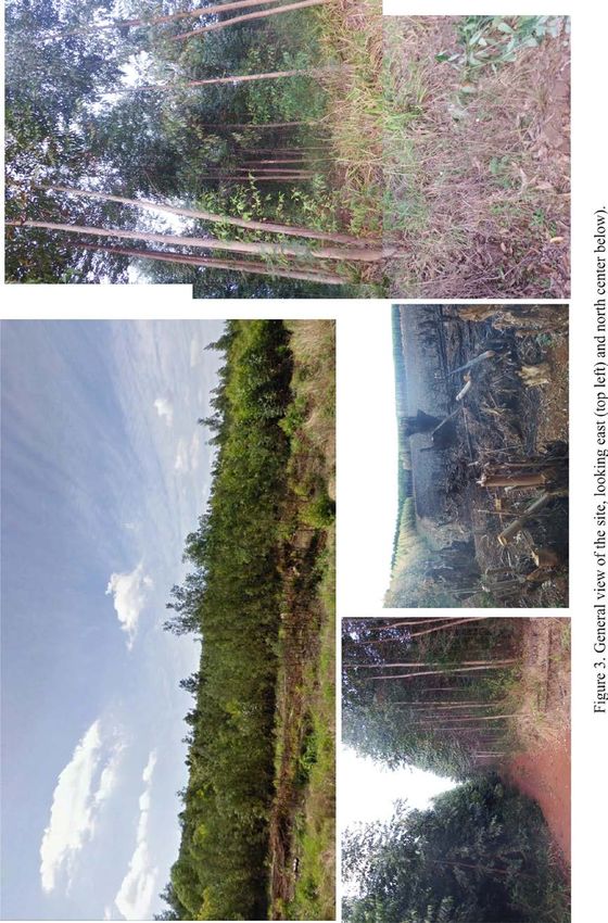
underlying bedrock is represented by siliciclastic sediments made up of sandstones,
minor mudrocks and conglomerates, deposited during a fluvial to shallow marine
transition as an epeiric sea advanced onto the Kaapvaal Craton around 2600 Ma ago
(Button 1973). colluvium and unconsolidated residual soils.
The Black Reef Formation has traditionally been regarded as a time equivalent of the
stromatolitic – bearing Vryburg Formation in Griqualand West (SACS, 1980), but
recent radiometric age dating of the overlying Oaktree Formation, suggest that
disconformities hidden above and within the Black Reef Formation may contradict
such a correlation (Walraven and Marlini 1995). The Black Reef Formation is
considered to be of low palaeontological sensitivity, although it is possible, albeit very
small, that micro-fossils contained in stromatolitic carbonates could be associated
with this rock unit. There is currently no record of Quaternary vertebrate fossils or
sites in the region and the likelihood of impact on such remains resulting from the
proposed development is considered to be very low.
Archaeology
The archaeological footprint of the region include a Stone Age, rock art, Iron Age as
well as historical remains represented by stone tool assemblage sites Iron Age
structures mines and battlefield sites (Bergh 1999) (Fig. 5 & 6). Sabie was originally
established on the farm Grootfontein and formed part of the famous gold-rush of the
1880’s. The first commercial trees were planted in 1876 which led to vast forestation
schemes in the area over the last 150 years.

                                      Field Assessment
Outcrop visibility is generally very poor given the intensive forestry development,
while the site has also been severely degraded by the tree-planting activities (Fig. 7).
There are no evident signs of in situ Stone Age archaeological sites or scatters,
prehistoric structures or historically significant structures older than 60 years. A small
informal graveyard (GPS coordinates 25° 4'31.49"S 30°48'13.15"E) with at least 10
graves and several modern-built, but dilapidated dwellings were recorded during the
survey (Fig. 8 - 10).

                        Impact Statement and Recommendation
Potential impacts are summarized in Table 2. The proposed development is expected
to primarily affect palaeontologically insignificant Quaternary overburden, made up
                                                                                        6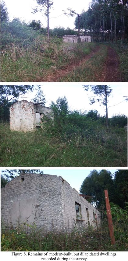
of severely degraded residual soil and alluvium, and siliciclastic sediments associated
with Black Reef Formation of the Transvaal Supergroup. As far as the overall
palaeontological heritage is concerned, likelihood of palaeontological impact resulting
from this development is considered low, given the disturbed terrain and lack of
suitable fossil-bearing rock. However, it is recommended that should any fossils be
uncovered within intact sedimentary rocks during the development, a suitably
qualified palaeontologist must evaluate the finds or monitor the exposed areas as soon
as possible.
It is evident that all potential aboveground or subsurface archaeological remains will
have been destroyed by the intensive forestation activities. As far as the
archaeological heritage is concerned, the proposed development footprint is
considered to be of low archaeological significance. Provided that the graveyard is
properly maintained, permanently fenced off and protected by a 10 m no-go buffer
zone during planned construction activities, the development footprint is assigned a
site rating of Generally Protected C.

                                        References
Bergh, J.S. 1999. Geskiedenisatlas van Suid Afrika: Die vier noordelike provinsies.
Van Schaik. Pretoria.
Button, A.1973. The stratigraphic history of the Malmani dolomite in the eastern and
north-eastern Transvaal. Transactions of the Geological Society of South Africa 76:
229 – 247.
Eriksson, P.G., Altermann, W. & Hartzer, F.J. 2006. The Transvaal Supergroup and
its precursors. In: Johnson, M.R., Anhaeusser, C.R. & Thomas, R.J. (Eds.) The
geology of South Africa, pp. 237-260. Geological Society of South Africa,
Marshalltown.
Klein, C., Beukes, N.J. & Schopf, J.W. 1987. Filamentous microfossils in the early
Proterozoic     Transvaal   Supergroup:    their   morphology,     significance    and
paleoenvironmental setting. Precambrian Research 36: 81-94.
Truswell, J.F. and Erikson K.A. 1972. The morphology of stromatolites from the
Transvaal dolomite north-west of Johannesburg, South Africa. Transactions of the
Geological Society of South Africa 75: 99 – 110.

                                                                                     7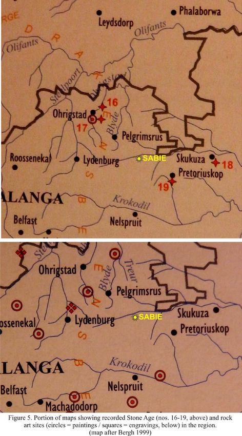
Walraven, F. and Martini, J. 1995. Zircon Pb-evaporation age determinations of the
Oaktree Formation, Chuniespoort Group, Transvaal Sequence: implications for
Transvaal- Griqualand West basin correlations. S. Afr. J. Geol., 98, 58-67.

DECLARATION OF INDEPENDENCE
I, Lloyd Rossouw, declare that I act as an independent specialist consultant. I do not
have or will not have any financial interest in the undertaking of the activity other
than remuneration for work as stipulated in the terms of reference. I have no interest
in secondary or downstream developments as a result of the authorization of this
project and have no conflicting interests in the undertaking of the activity.

18 / 05 / 2018

                                                                                    8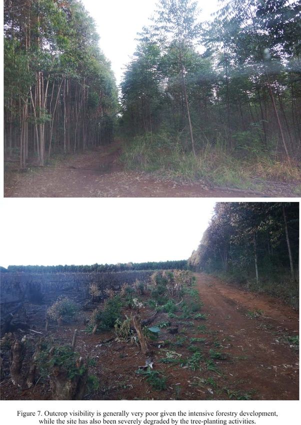
Tables and Figures

               Table 1. Field rating categories as prescribed by SAHRA.
Field Rating          Grade                 Significance         Mitigation
National              Grade 1               -                    Conservation;
Significance (NS)                                                national site
                                                                 nomination
Provincial            Grade 2               -                    Conservation;
Significance (PS)                                                provincial site
                                                                 nomination
Local Significance    Grade 3A              High significance    Conservation;
(LS)                                                             mitigation not
                                                                 advised
Local Significance    Grade 3B              High significance    Mitigation (part of
(LS)                                                             site should be
                                                                 retained)
Generally Protected -                       High/medium          Mitigation before
A (GP.A)                                    significance         destruction
Generally Protected -                       Medium               Recording before
B (GP.B)                                    significance         destruction
Generally Protected -                       Low significance     Destruction
C (GP.C)

                                                                                       9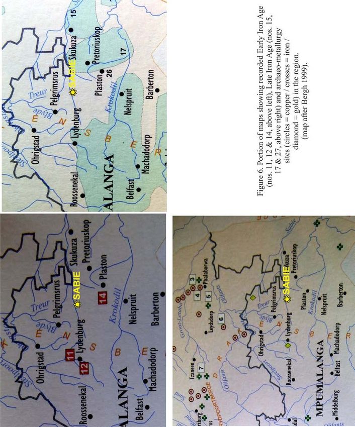
Table 2. Summary of potential impacts.

                                                                                                                                     Heritage Impact after
                                                                                                                Development Impact
                            Rock types and Age

                                                       heritage in region
                                                       Palaeontological /

                                                                            Palaeontological
     Geological Unit

                                                        Archaeological

                                                                                               Archaeological
                                                                              significance

                                                                                                significance
                                                           Potential

                                                                                                                                            survey
Regolith               Alluvium,                 Rare (localized) large
                       residual                  vertebrate skeletal
                       soils.                    remains, coprolites,
                       Quaternary                microfossils,
                       to Recent                 in alluvial or
                                                 lacustrine (pan)
                                                 contexts;

                                                                                                High

                                                                                                                High
                                                                              Low

                                                                                                                                     Low
                                                 Intact or uncapped
                                                 stone tool
                                                 assemblages,
                                                 Rock art,
                                                 Prehistoric structures
                                                 (Iron Age);
                                                 Historical structures;
                                                 Graves/graveyards
Black Reef             Sandstones,               Rare chance of
Formation              minor                     stromatolitic
(Transvaal             mudrocks                  carbonates
Supergroup)            and
                       conglomerat
                       es,
                       deposited
                                                                                                                High
                                                                              Low

                                                                                                Low

                                                                                                                                     Low

                       during a
                       fluvial to
                       shallow
                       marine
                       transition.
                       Late
                       Archaean

                                                                                                                                                             10
11
12
13
14
15
16
17
18
19
20
You can also read