Planning for Chippenham - January 2021 Chippenham - Wiltshire Council
←
→
Page content transcription
If your browser does not render page correctly, please read the page content below
January 2021

                          Chippenham

Planning for Chippenham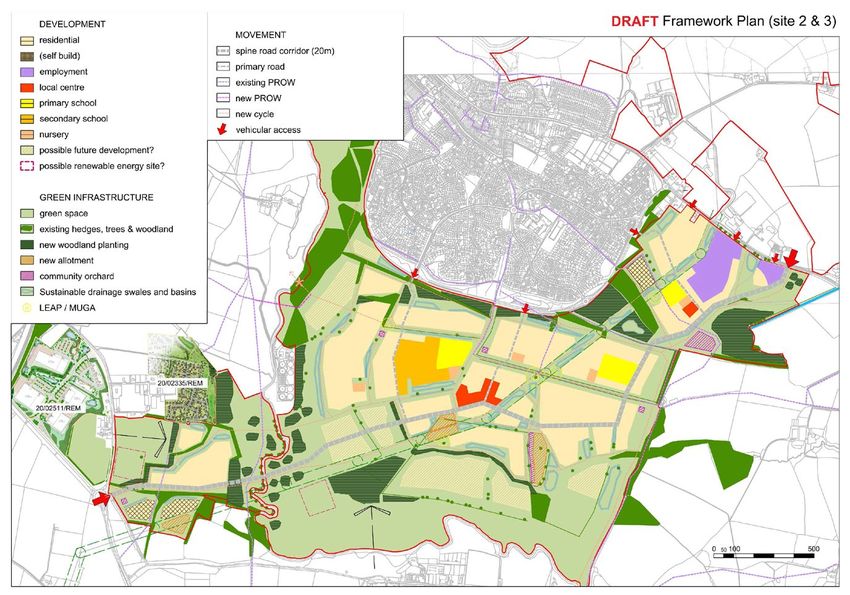
Contents
         Introduction                                    3
         Scale of growth                                 3
            How much should the town grow?               3
            Additional homes                             3
            The Local Economy                            4
         Place shaping priorities                        5
            What priorities should we tackle?            5
         Potential Development Sites                     6
            Where should development take place?         6
         Concept plans                                   9
         Settlement profile                              19

                                                              2
Wiltshire Council Local Plan - Planning for Chippenham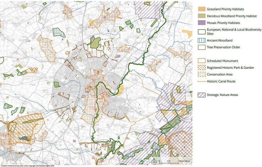
Introduction
1. What will Chippenham be like in the future? 4. The Core Strategy is the basis for
• How much should the town grow? determining most planning applications.
It also identifies land for development
• What priorities should we tackle?
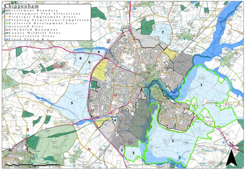
that provides for new homes, jobs and
• Where should development take place? infrastructure for our growing communities
2. Answers to these fundamental questions whilst balancing the need to protect the
could affect how the town develops over the environment. The Local Plan will continue this
next 15 years. role and therefore help shape the places the
community of Wiltshire live and work within.
3. The Council is thinking about these
questions in planning Wiltshire’s future. It’s 5. The Council has come to some initial
an important stage in the Council’s review of answers to these three questions. It is
the current Wiltshire Core Strategy and the sharing them and wants your views.
development of the Local Plan.
Scale of growth
How much should the town grow?
6. The Council assesses what amount of new The new strategy 2016-2036
homes are needed between 2016 and 2036,
the period of the Local Plan. It does the
same for how much land will be needed
for new jobs and business. Detail on these
requirements may be found in the ‘Emerging The current strategy 2006-2026
Spatial Strategy’ paper.
Additional new homes
Additional homes 0 1000 2000 3000 4000 5000 6000 7000 8000 9000 10000
7. Assessments estimate levels of need for
new homes within housing market areas, 9. The current strategy 2006-2026, the Wiltshire
as these reflect where the majority of the Core Strategy, identified a requirement for
local population live and work, where the 4510 homes. The new strategy proposes
majority of home moves take place and a requirement of 9225 homes for the plan
where there is a common range of private period 2016-2036.
sector rents. There are four housing market 10. From this total estimate of need over the
areas in Wiltshire and each area includes plan period can be deducted homes already
many settlements. Chippenham is in the built and those already in the pipeline as
Chippenham Housing Market Area. shown in the diagram on the following page.
8. The Council has considered how best to 11. When the number of homes built and in the
accommodate the need for new homes, pipeline is deducted it leaves a further 5100
setting scales of growth by testing different homes to be accommodated up until 2036.
distributions. The result of this work Both the Local Plan and neighbourhood plan
suggests the scale of growth should change can allocate sites for development. Each
from what is currently planned as shown. community is encouraged to help determine
1
In Chippenham 394 dwellings have been built between 2016-2019 and, at 1 April 2019, 3733 dwellings are already in the
pipeline (i.e. the have planning permission, resolution to grant planning permission or are allocated for development in the
Chippenham Site Allocations Plan).
3
Wiltshire Council Local Plan - Planning for Chippenham
where development takes place though the                    17. Alongside neighbourhood plans,
    preparation of a neighbourhood plan. The                        development briefs for individual sites and
    Local Plan will allocate land where necessary                   master plans for larger areas, are a means
    to ensure supply of deliverable land to meet                    for the community, with developers and land
    strategic housing needs and for large or                        owners, to help bring forward brownfield
    complex sites.                                                  opportunities and achieve appropriate
12. In Chippenham, the Chippenham                                   designs.
    Neighbourhood Plan may identify sites on                      Homes already       Homes already in   Homes to be
    which some of these homes could be built.                     built (2016-2019)   the pipeline       planned for
    The Neighbourhood Plan will also be able
    to propose sites, for example, that meet a
    particular housing need e.g. self-build or
    for other uses, or that positively plan for                                                    Additional new homes
    brownfield sites.                                            0   1000 2000 3000 4000 5000 6000 7000 8000 9000 10000

13. Needs for development land should be met as
    far as possible on brownfield sites in order to             The Local Economy
    help minimise the loss of greenfield land. The              18. The Council has assessed what additional
    Council suggests that a target of 240 homes                     land is needed for business in each of
    could be built in Chippenham on brownfield                      the economic zones of the County. These
    sites over the next 10 years2.                                  zones encompass many settlements. It
14. The Local Plan ensures that the proposed                        has considered how best to accommodate
    scale of growth will be accommodated; where                     needs for new business by testing different
    necessary to ensure supply of deliverable                       distributions2.
    land to meet strategic housing needs and                    19. On current evidence, 5 ha additional
    to help deliver large or complex sites. It                      employment land is needed at Chippenham.
    must be certain that there is a land supply
    sufficient to meet assessed need. It cannot                 20. Chippenham remains a healthy town centre,
    rely on the brownfield target being met by as                   which has been able to adapt to the on-
    yet unidentified windfall redevelopment, the                    going trends facing the UK retail sector and
    scale or timing of which is uncertain.                          also the significant changes in out of centre
                                                                    floorspace in the town. The town centre has
15. Meeting a brownfield target will instead                        seen falling vacant retail units alongside
    reduce the need for greenfield sites in                         changes to the comparison goods and
    future reviews of the Local Plan. This could                    service sectors, which have mirrored the
    be positively addressed through revised                         national trend.
    neighbourhood plan. Sites identified formally,
    with sufficient certainty, either in the                    21. Given the growing amount of food store
    development plan or by granting planning                        floorspace outside of the town centre, the
    permission, reduce the need.                                    centre will increasingly concentrate upon
                                                                    top-up food shopping trips and there is a
16. Planning positively for brownfield sites,                       need to ensure that the High Street and the
    however, can also work alongside allocations                    two purpose-built shopping areas (Emery
    of greenfield land. Where there can be                          Gate and Borough Parade) continue to
    certainty about brownfield sites coming                         underpin the health of the centre
    forward, then this will reduce the amount of
    greenfield land sought in this review of the                22. The Bath Road Car Park and Bridge Centre
    plan.                                                           Site remains the opportunity to introduce
                                                                    new land uses into the town centre.

Further detail can be found in the Emerging Spatial Strategy (2021) paper.
2

                                                                                                                       4
Wiltshire Council Local Plan - Planning for Chippenham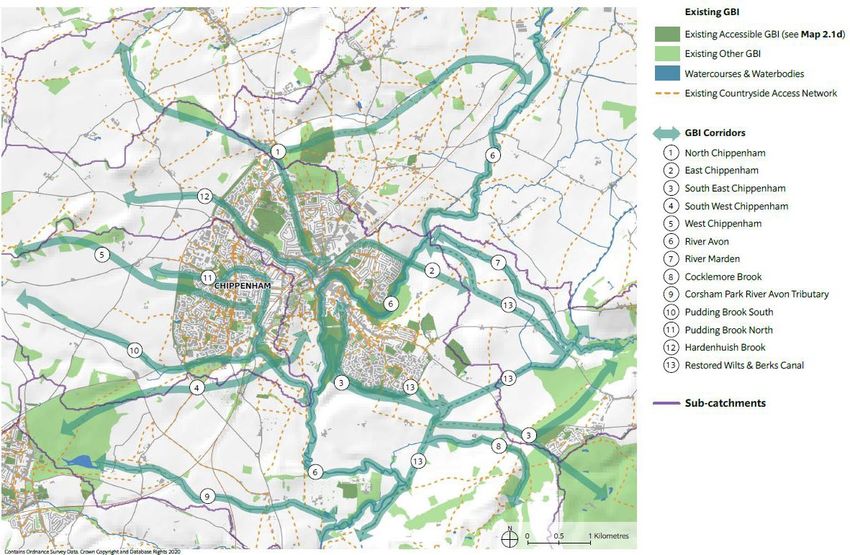
Questions

    CP1. What do you think to this scale of growth? Should there be a brownfield target?
    Should they be higher or lower?

Place shaping priorities
What priorities should we tackle?                        i.   Development to provide new employment
23. The Local Plan will contain a set of place                opportunities with a strong emphasis on
    shaping priorities for each main settlement.              timely delivery to redress the existing levels
    They play a central role in developing                    of net out-commuting within the town and
    planning policies and proposals for                       enable people to live and work locally.
    development. They will be the basis for an           ii. Improving the resilience of the town
    overarching planning policy for Chippenham               centre by:
    that will guide development and the                       •   Serving as a centre for sub-regional
    direction of growth.                                          public services; and retaining a mix
24. Some priorities apply equally everywhere,                     of national traders and attracting
    notably the need to address climate change                    independent traders whose presence
    and achieve carbon reduction. Place shaping                   will imbed its Market Town character.
    priorities are intended to be those distinct to           •   Ensuring the Town Centre will be
    a particular place. They may include:                         a vibrant meeting place for the
•   Important local objectives or issues and how                  community to shop, interact and
    they can be addressed                                         enjoy their leisure time, and a visitor
•   Opportunities that have been identified that                  destination in its own right.
    can help support a local community’s vision               •   Preserving and enhancing the special
•   Infrastructure requirements for which there                   historic character of the Town Centre.
    are local aspirations and capable of delivery             •   Developing the Bath Road Car park/
    or that are necessary to support likely future                Bridge Centre site as a mixed-use
    growth                                                        scheme which complements and
25. They must relate to the development and                       enhances the town centre and
    use of land and so should revolve around                      secures completion of planned
    specific outcomes and their benefits.                         highways improvements.
26. They are also a starting point for policies that          •   Continuing to make improvements
    can be in neighbourhood plans. The Council                    to Chippenham Railway Station and
    will continue to work with Chippenham Town                    Cocklebury Road area to attract
    Council and surrounding Parish Councils to                    inward investment to this area.
    finalise the priorities for Chippenham. These
                                                              iii. Improved access to the River Avon
    are the draft priorities for Chippenham,
                                                                   valley through Chippenham as an
    which we are seeking your views on:
                                                                   important green Infrastructure
                                                                   corridor for the town.
                                                         iv. Ensuring a network of well-connected
                                                             footpaths and cycleways and connectivity
                                                             for public transport across the town, to/

                                                                                                            5
Wiltshire Council Local Plan - Planning for Chippenham
from the town centre, and through into                  town centre.
     the surrounding countryside, so that more            vi. Respect the individual identities of
     people can choose active travel and public               villages within the landscape setting of
     transport as a means of getting around                   Chippenham and their relationship to the
 v. Linking the A4 to the A350 which will                     town.
    provide for a more resilient local network
    addressing traffic congestion within the

    Questions

    CP2. Are these the right priorities? What priorities may be missing? How might these place
    shaping priorities be achieved?

Potential Development Sites
Where should development take place?                     29. The focus here is on the difficult central
27. Land around much of Chippenham is being                  decisions of where and how the built-up
    promoted for development by landowners                   area needs to extend – greenfield sites.
    or prospective developers. From this larger              Each potential development site has its
    amount of land, the Council focussed                     own individual characteristics. Rarely is
    its own assessment on a smaller pool                     one site very clearly the best choice. There
    of potential development sites and has                   are a range of different constraints and
    selected preferred ones. A map illustrating              opportunities associated with each. Some
    this pool of potential development sites and             are common to several or even all potential
    the preferred sites is provided below. How               development sites.
    these sites have been chosen is explained in         30. Preferred development sites are based on
    a separate ‘site selection report’, published            two new suburbs to Chippenham shaped
    alongside this document.                                 by the landscape and by climate change
28. The Local Plan ensures the proposed scale                mitigation. They combine sites 1, 2 and 3
    of growth will be accommodated. The                      resulting from the site selection process.
    amount to be planned for takes account               31. The size of these areas is likely to see
    of development that is already certain                   construction continuing beyond the
    and in the pipeline, including as many                   end of the plan period (2036). This scale
    brownfield sites as can be relied on, such               of proposals allows us to set in place a
    as those with planning permission. The                   new long term boundary to the town.
    re-use of previously developed land within               It also provides long term certainty to
    the existing urban area will continue to                 infrastructure providers and other service
    be supported, as this reduces the need to                providers.
    lose more countryside and generally such             32. Planning at scale also provides better
    opportunities can be better located and can              opportunities to moderate additional carbon
    relieve pressures for new infrastructure;                emissions. It secures large areas of land
    as well as helping regenerate urban                      that help the town adapt to flood risks and
    areas. However, the scale of growth for                  heatwaves such as from more frequent
    Chippenham is so substantial that significant            extreme weather events including providing
    greenfield sites need to be identified.                  land to enhance biodiversity and protect

                                                                                                       6
Wiltshire Council Local Plan - Planning for Chippenham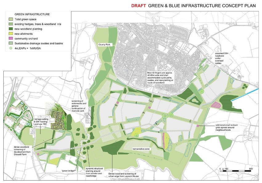
habitat and providing a critical demand mass         33. The proposals offer opportunities for a
    that will enable off-grid renewable energy               properly integrated and comprehensive
    generation to help meet needs for such                   network for pedestrians and cycles, seeking
    things as vehicle charging and the switch to             to reduce the need to travel by car. It will
    carbon free domestic heating. Opportunities              also provide for a mix of dwelling styles
    for renewable energy are being explored                  and forms, including from self-build and
    by the Town Council preparing its                        provision by small to medium sized building
    neighbourhood plan. Off grid generation                  firms, all of whom will be required to
    and other potential measures on these sites              produce buildings to the highest sustainable
    will build on this work and need to integrate            construction methods.
    with opportunities and benefits that may be
    realised for the whole town.

    Questions

    CP3. Do you agree these sites are the most appropriate upon which to build? If not, why not?

    CP4. What are the most important aspects to consider if these sites are going to be built on?

                                                                                                      7
Wiltshire Council Local Plan - Planning for Chippenham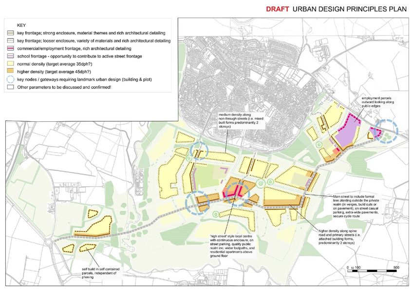
Figure 1 Stage 3 Sustainability Appraisal map with Preferred development sites highlighted

                                                                                                 8
Wiltshire Council Local Plan - Planning for Chippenham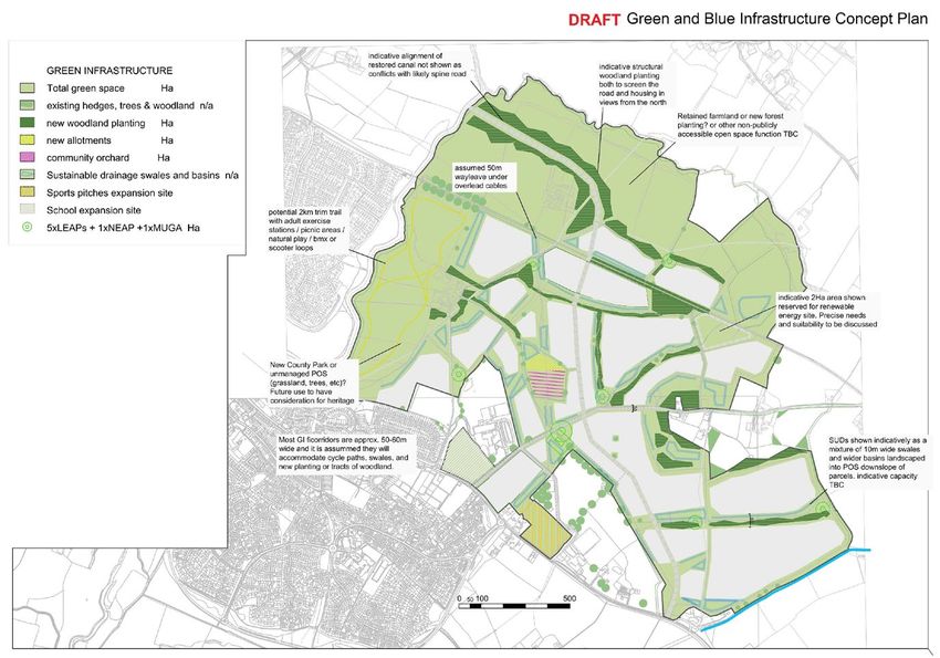
Concept plans
34. Whilst looking to the future, development            40. Against each concept plan, we highlight
    must fit with Chippenham as it is now.                   aspects and invite views on how the
    Concept plans for each area show a way the               approach can be improved. Further
    land identified can be developed. They show              development of the ideas here would
    the undeveloped land, areas suggested for                culminate in design codes developed
    development and possible locations for uses              alongside master plans for each site. It is
    within them.                                             intended that these will be based around a
35. They show what land would be left                        design guide being prepared as part of the
    undeveloped to help maintain the setting                 Town Council’s neighbourhood plan. The
    of the town, important views, access to the              guide will express the community’s needs
    countryside and the setting and separate                 and requirements for good design locally.
    identity to villages in the wider area. They             Development would only be permitted to
    identify areas where there will be planting to           take place in accordance with an approved
    provide an attractive and interesting urban              master plan.
    edge.                                                41. The draft design principles incorporated at
36. They also show possible locations for                    this stage are set out below:
    infrastructure and facilities necessary to            Design Principles
    support a growing community. The concept
    plans show the suggested locations for new            •   A new suburb shaped mostly by the existing
    primary schools, the expansion of Abbeyfield              landscape, but also by future climate change
    Secondary School and a new secondary                      flood mitigation.
    school, plus additional space for formal              •   A housing density of 35 dwellings per
    sports, allotments and other such uses.                   hectare. However, this is capable of being
37. It has been established that any meaningful               a higher density in and around the local
    growth at Chippenham, small or large,                     centres and main High Street areas.
    requires a new road link from the A4 north            •   A vast network of radial, off street cycleways
    to the A350. Otherwise there is unacceptable              linking all parts of the site through green
    congestion on the road network around the                 routes, in particular schools.
    town centre.
                                                          •   Larger development parcels broken up with
38. It is highly likely, but not so certain, that a           green corridors, so as to allow space for
    second road link from the A4 will also be                 sustainable urban drainage, wildlife and
    needed as Chippenham continues to grow.                   canopy growth.
    This is a route south from the A4 to the
                                                          •   A new tree lined main street forms the spine
    A350. This is also shown on the concept
                                                              of each new neighbourhood. Designed
    plans for sites 2 and 3. The Council has
                                                              initially as a 40-50 mph road, it will also be
    made a successful bid to fund the road’s
                                                              capable of being amended to 20-30 mph.
    construction, if these proposals go ahead.
    A new road is shown on the concept plan               •   Community facilities are placed along or
    for site 1.                                               close to this spine road and cycle network.
39. The concept plans illustrate one way each             •   Heritage Assets are marked as opportunities
    of the sites could be developed. There are                for suitable future uses. Their settings
    different ways. This consultation invites                 are addressed with a balance of any new
    everyone to offer their ideas and give                    buildings set back and wooded screen
    us their views on the most appropriate                    planting.
    locations for growth and the form it should           •   A substantial amount of green space
    take.                                                     remaining undeveloped with various options

                                                                                                            9
Wiltshire Council Local Plan - Planning for Chippenham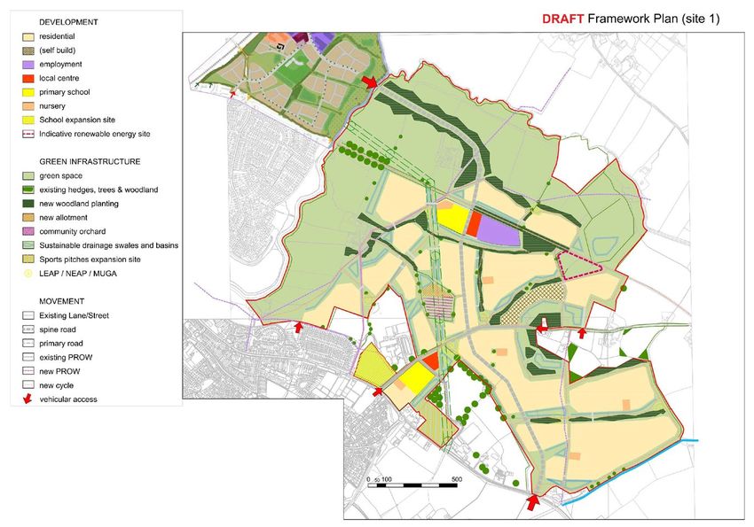
as to its future use and management e.g.            Land for renewable energy site
     Renewable energy land use or rewilding              Walking and Cycling links to and from the
     project.                                            town centre, Abbeyfield School and nearby
 •   Part of large areas of green infrastructure,        settlements including Bremhill, Tytherton
     play areas, orchards and allotments are             Lucas and Calne
     located within these areas, to be structured        Transport corridor linking A4 with A350
     either formally or informally. Green                northwards
     infrastructure could provide areas for
     informal exercise, park runs, seating areas,
     picnic areas etc.
                                                         Site 2 South Chippenham (page 15-18)
                                                         Land at South Chippenham is proposed for
 •   All homes are within close proximity to
                                                         a mixed-use development to include the
     communal greenspace and an off street
                                                         following:
     walking/cycling network.
                                                         2415 houses to include self and custom build
 •   All homes are within 400m of a Local
                                                         plots and specialist housing.
     Equipped Area of Play (LEAP).
                                                         Approximately 5ha Employment Land
42. A box for each site lists the main uses              District and Local Centre
    proposed for each site. A set of concept             Community Uses
    plans illustrate how each area could be              Land for allotments
    developed. A framework plan provides an
                                                         Land for Community Orchard
    overview. Three other plans look at specific
                                                         Open space provision to include an
    aspects: green and blue infrastructure,
                                                         extension of the Riverside Country Park
    movement and urban design principles.
    Together, the plans illustrate one way the           Land for 1 10FE Secondary School
    area could be developed. Comments are                Land for 3 2FE Primary Schools
    invited on all aspects of the proposals,             Land for 2 100 space nurseries and 1 80
    but there are a set of questions to prompt           space nursery
    consideration and some particular questions          Land for renewable energy
    around elements of a proposal.
                                                         Walking and Cycling links to the town centre
                                                         and nearby settlements including Lacock
 Site 1 East Chippenham (page 11-14)
                                                         and Derry Hill.
 Land at East Chippenham is proposed for
                                                         Distributor Road linking A4 with A350
 a mixed-use development to include the
                                                         southwards
 following:
 Approximately 2975 dwellings to include
 self and custom build plots and specialist              Site 3 East of Showell Farm (page 15-18)
 housing.                                                Land at East of Showell Farm is proposed
 Approximately 3ha Employment Land                       for a mixed use development to include the
 District Centre and Local Centre                        following:
 Community Uses                                          196 houses to include self and custom build
                                                         plots and specialist housing.
 Land for allotments
                                                         Open space provision to include an
 Land for a Community Orchard
                                                         extension of the Riverside Country Park.
 Open space provision to include an eastern
                                                         Land for renewable energy
 extension of the Riverside Country Park
                                                         Walking and Cycling links to the town centre
 Land to expand Sports Ground
                                                         and nearby settlements including Lacock.
 Land for 2 Two Form Entry Primary Schools
                                                         Distributor Road linking A4 with A350
 Land for 4 100 space Nurseries

                                                                                                     10
Wiltshire Council Local Plan - Planning for Chippenham
Figure 2 Concept map for Site 1 East Chippenham showing boundary outline and proposed
layout and land uses, within which to accommodate development
11
Wiltshire Council Local Plan - Planning for ChippenhamFigure 3 Concept map for Site 1 East Chippenham showing green and blue infrastructure
12
Wiltshire Council Local Plan - Planning for ChippenhamFigure 4 Concept map showing key movement routes within and connected to Site 1 East Chippenham
13
Wiltshire Council Local Plan - Planning for ChippenhamFigure 5 Concept map for Site 1 East Chippenham showing urban design principles
14
Wiltshire Council Local Plan - Planning for ChippenhamFigure 6 Concept map for Site 2 and 3 South Chippenham and East of Showell Farm showing boundary
outline and proposed layout and land uses, within which to accommodate development
15
Wiltshire Council Local Plan - Planning for ChippenhamFigure 8 Concept map for Site 2 and 3 South Chippenham and East of Showell Farm showing green and blue infrastructure
16
Wiltshire Council Local Plan - Planning for ChippenhamFigure 9 Concept map showing key movement routes within and connected to
Site 2 and 3 South Chippenham and East of Showell Farm
17
Wiltshire Council Local Plan - Planning for ChippenhamFigure 10 Concept map for Site 2 and 3 South Chippenham and East of Showell Farm showing urban design principles
18
Wiltshire Council Local Plan - Planning for ChippenhamQuestions
CP5. How can these concept plans be improved?
CP6. Do you agree with the range of uses proposed, what other uses should be considered?
CP7. Do you agree with the location of the proposed uses? What should be located where -
and why?
CP8. Do you agree with the location and amount of employment provided on Sites 1 and 2?
CP9. Do you agree with the proposed locations for self build and custom build housing?
Would you prefer alternative locations?
CP10. Do you agree with the proposed sites for renewable energy? Is there a particular type
of renewable energy that should be provided?
CP11. Site 1 – Do you agree with the proposal for some housing to be located north of the
North Rivers cyclepath?
CP12. Site 1 – Are there any uses that would be most suitable for Hardens Farm and New
Leazes Farm?
Settlement profile
43. When planning for growth it is important to consider the characteristics of the town in terms
of services and infrastructure (green infrastructure, health, education, transport and utilities),
as well as housing need and the local economy. Such factors can help us consider how we plan
for change. The following profiles therefore summarise measures in place or being put in place
to address known infrastructure issues and their timing, what additional provision would be
needed to support growth and what other opportunities there may be. These have been used to
shape the concept plans.
Questions
CP13. Is there anything we have missed that needs to be considered in planning for
Chippenham?
19
Wiltshire Council Local Plan - Planning for ChippenhamTopic Comment
Education New early years provision is required to meet needs arising from new development.
There is no existing capacity within the primary schools at the Town.
There is no existing capacity within secondary schools at the Town. Abbeyfield
School is due to be expanded to accommodate needs arising from existing new
development.
To accommodate the amount of development proposed will require:
Primary School Provision – 5 2 Form Entry schools
Secondary School Provision – 1 10 Form Entry school
Nursery Provision – 6 100 place nurseries; 1 80 place nursery. Each primary school
will also incorporate a nursery.
Energy According to Scottish and Southern Electricity Network’s (SSEN’s) - Generation Availability
Map, the substation and supply points around Chippenham are currently either relatively
unconstrained or constrained in relation to energy generation. Considering the scale and
proposed location of growth at the town, on the basis of available evidence, there may
be a need for investment in the infrastructure to be able to connect to and potentially
reinforce the grid.
For the amount of development proposed, it would be possible to include significant
renewable energy generation, both within buildings and in areas of open space. Low
carbon community infrastructure such as district heating could also be incorporated.
There is no existing district heating network to link into.
Green and blue Appropriate land uses, footpaths and cycleways should be geared to boosting the
infrastructure attractiveness of the town centre to visitors and investment, as part of wider priority to
improve its resilience
Access to the River Avon valley through Chippenham will be improved. Extension of the
open space along the river to the east of Chippenham, as well as to the south. Combined
with the historic centre, the market, pleasant parks and open spaces, this will create a
thriving artery and distinctive identity for the town. It will also be managed to allow better
use as informal open space for leisure, to deliver ecological improvements as well as
ensuring surface water management adapts to the effects of climate change.
There are opportunities to improve the green corridor links between the town and Calne
and nearby villages including Lacock, Tytherton Lucas and Bremhill to encourage active
travel routes.
A multi-functional ‘Local Green Blue Infrastructure (GBI) Network’ has been identified and
is shown on the map in Figure 10 below. The Map indicates areas where improvements
will need to be sought – i.e. in the form of functional and sufficiently scaled corridors
within which the aim would be to consolidate and incorporate new green and blue spaces
into the existing GBI networks.
The map in Figure 11 below identifies biodiversity and heritage assets which are also GBI
assets. These features are important waypoints within the existing landscape and should
be considered as being integral to how new development areas are sensitively planned
There is a need for more allotments.
20
Wiltshire Council Local Plan - Planning for ChippenhamTopic Comment
Sport and At Chippenham there is a need for the following, as identified by the Wiltshire
Leisure Facilities Playing Pitch Strategy:
• Chippenham is currently well provided for in terms of sports pitches.
Stanley Park is the likely focus for football provision going forward and has
potential for further expansion. If there is major expansion on the M4 side of
Chippenham there may be the need to consider another 3GATP at that side of
Chippenham or another at Stanley Park
• Chippenham Sports Club facilities, especially hockey, will require ongoing
improvement and expansion. For Hockey this will require another Artificial
Turf Pitch.
Leisure Facilities
• Wiltshire Council is in the process of undertaking a Leisure Facility Needs
Analysis. Any requirements relating to the Olympiad, or future provision of
leisure facilities in Chippenham will be informed by this work, which will include
planned growth and demand.
Health There are 4 GP surgeries in Chippenham.
Lodge Surgery is being redeveloped internally to support an increasing population.
Hathaway Surgery has some capacity for new patients, but other practices do not.
Chippenham Hospital has been identified for potential redevelopment or new build
to provide additional NHS services in the town.
Housing needs In the years 2016-2036 the older population is expected to increase by 23% in the
60-74 age group and 81% in the 75+ age group.
At the same time the 0-14 age group is expected to decrease by 3% and the 15-29
age group to increase by 2%.
Finally, the 30-44 age group is expected to decrease by 2% and the 45-59 age group
to decrease by 10%.
Local household income: average annual gross income is £40,700, and the net
income after housing costs is £27,000
Affordability ratio (based on 2 bed property): Median price £204,200 (annual
gross income £40,700) makes an affordability ratio of 4.76
The local Chippenham, one of many vibrant market towns, is located with the Swindon and
economy Wiltshire Local Enterprise Partnership (LEP) Growth Zone, which has the highest
density of businesses in the LEP area.
The market is interested in Chippenham, and there is scope for more land to be
allocated. Recent investment by Woods Valladata Group HQ on land at Bumpers
Farm.
Sites granted planning permission recently include Land at J17, M4 (St Modwen
Park) for use class B8 Storage and Warehousing uses.
Over the Local Plan period, there is demand for between 12ha and 25ha of
employment land in Chippenham, and there is a current supply of 29Ha. In the first
five years of the plan period, there is an excess of supply over demand. However,
over the full Local Plan period, new allocations may be needed. New allocations
should be considered in Chippenham, to meet both market demand and public
policy aspirations. There are strong drivers of growth in Chippenham in particular,
which is attractive to the market and is a principal town in the Local Plan, so existing
sites should be protected, and new allocations considered here.
Chippenham remains a healthy town centre, which has been able to adapt to the
on-going trends facing the UK retail sector and also the significant changes in out of
centre floorspace in the town.
21
Wiltshire Council Local Plan - Planning for ChippenhamThe town centre has seen falling vacant retail units alongside changes to the
comparison goods and service sectors, which have mirrored the national trend.
Given the growing amount of food store floorspace outside of the town centre, the
centre will increasingly concentrate upon top-up food shopping trips and there is
a need to ensure that the High Street and the two purpose-built shopping areas
(Emery Gate and Borough Parade) continue to underpin the health of the centre.
Convenience goods floorspace
There is modest capacity for net additional floorspace.
The quality of the convenience retail offer in the town centre has the potential for
improvement and it is likely that should the Council permit either or both of the
current ALDI and Lidl foodstore applications then the available quantitative capacity
will be eliminated.
Comparison goods floorspace
There is no requirement to plan for net additional floorspace over the plan
period. The town has seen considerable change and growth in out of centre
retail floorspace over the past decade and whilst this does not appear to have
fundamentally affected the health of the town centre in the short term, we consider
that the overall retail offer of the town is sufficient not to plan for any net additional
floorspace.
Bath Road car park and adjacent Bridge Centre site
Remains the most obvious opportunity to introduce new land uses into the town
centre. This area has long been discussed and assessed in terms of the ability to
provide new retail and leisure floorspace although various proposals over the past
dozen or so years have not come to fruition which are in part due to the ability to
provide out of centre comparison goods retail units. Any redevelopment potential
will be dependent on: (A) the effect upon car parking capacity in Chippenham
town centre; (B) a wider range of land uses being considered (moving away from a
retail-led redevelopment in favour of a more balanced mixed-use scheme involving
residential uses).
Transport Key Features
Chippenham is located adjacent to the A350 primary route corridor which provides
north-south links in west Wiltshire to the M4 in the north and A36 in the south.
Other main routes include the A4 linking to the west towards Bath and east towards
Calne and Marlborough, and the A420 linking to Bristol in the west and Swindon in
the east.
The above routes are serviced by bus routes with regular 20 minute services to Bath
and Swindon with others providing links to other surrounding towns and many
neighbouring villages. Chippenham also benefits from a bus station.
Chippenham Railway Station, well connected to the town centre, is served by the
The Great Western Mainline providing direct rail links to Bath, Bristol and onwards
to South Wales in the west and Swindon, Reading and London to the east.
Current constraints/local concerns
• AM and PM peak hour delays particularly on the A350, A4 and the A420.
• Congestion within the town centre at the Bridge Centre gyratory and Park Lane/
New Road/Marshfield Road one-way system to the north of the town centre
• The A350 around Chippenham carries the highest volume of vehicles and HGVs
on Wiltshire’s Primary Route Network.
22
Wiltshire Council Local Plan - Planning for ChippenhamOpportunities
• A new eastern road linking the A4 with the A350 through Rawlings Green and
North Chippenham is identified as being required to help address congestion in
and around the town centre. A southern distributor road linking the A4 with the
A350 at the Lackham roundabout may be required.
• The potential options for housing sites for Chippenham are located on the outer
edges of the towns. This will require good quality radial cycle routes and safe
cycle storage facilities if high levels of mode shift from car to bicycle are to be
realised.
23
Wiltshire Council Local Plan - Planning for ChippenhamFigure 11 Map showing Chippenham Green and Blue Infrastructure Network and improvement corridors (numbered).
(These are draft plans from the emerging Green and Blue Infrastructure Strategy and may change)
24
Wiltshire Council Local Plan - Planning for ChippenhamFigure 12 Map showing Chippenham Green and Blue Infrastructure Assets in relation to Biodiversity and
Heritage. (These are draft plans from the emerging Green and Blue Infrastructure Strategy and may change)
25
Wiltshire Council Local Plan - Planning for ChippenhamWiltshire Council Local Plan Planning for Chippenham All material within this document is copyright Wiltshire Council except where indicated otherwise and may not be used, copied, or reproduced without permission. All rights reserved.
This document was published by the Spatial Planning Team,
Economic Development and Planning, Wiltshire Council
For further information please visit the following website:
www.wiltshire.gov.uk
You can also read