POINTS OF INTEREST PRODUCT INFORMATION - ORDNANCE SURVEY GB - Ordnance ...
←
→
Page content transcription
If your browser does not render page correctly, please read the page content below
ORDNANCE SURVEY GB

POINTS OF INTEREST
PRODUCT INFORMATION

OFFICIAL
Ver 4.2
© Ordnance Survey Ltd 2021
POINTS OF INTEREST – PRODUCT INFORMATION
August 2021

Version history

Version     Date                Description
4.0         09/2019             Specification change
4.1         12/2020             Specification change – Removal of verified address
4.2         08/2021             Specification change – Removal of provenance categories and media
                                format

Purpose of this document

This document provides information about and insight into the Points of Interest product and its potential
applications. For information on the contents and structure of Points of Interest, please refer to the
Technical Specification.

The terms and conditions on which Points of Interest is made available to you and your organisation are
contained in that Ordnance Survey customer contract. Please ensure your organisation has signed a valid
current customer contract to be able to use Points of Interest.

We may change the information in this document at any time, giving you the notice period set out in your
contract. We do not accept responsibility for the content of any third-party websites referenced or
accessed in or through this document.

This document has been screened according to Ordnance Survey's Equality Scheme. If you have difficulty
reading this information in its current format and would like to find out how to access it in a different
format (braille, large print, computer disk or in another language), please contact us on:
+44 (0)3456 05 05 05.

Copyright in this document

© Ordnance Survey Limited 2021. This document (including for the avoidance of doubt, any mapping
images reproduced within it) is protected by copyright and apart from the rights expressly granted within
this document to use the content, all rights are reserved. Any part of this document may be copied for use
internally in your organisation or business so that you can use Points of Interest under the terms of your
licence (but not otherwise).

No part of this document may be reproduced or transmitted in any form or by any means (including
electronically) for commercial exploitation, onward sale or as free promotional material without getting the
written consent of Ordnance Survey beforehand.

Trademarks

Ordnance Survey, OS and the OS Logos are registered trademarks, and Points of Interest is a trademark of
Ordnance Survey, Britain’s mapping agency.

PAF, PO Box, Post Office and Royal Mail are registered trademarks of Royal Mail Group Ltd.

PointX trademark being a trademark of PointX Limited.

Contact details

OS website ‘Contact us’ page (https://www.ordnancesurvey.co.uk/contact-us).

OFFICIAL
                                                                                                  Page 2 of 37
© Ordnance Survey Ltd 2021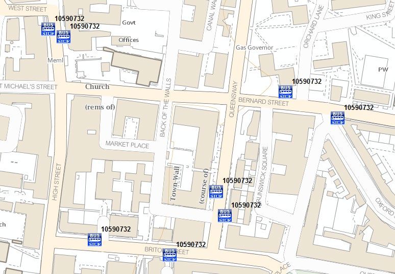
POINTS OF INTEREST – PRODUCT INFORMATION
August 2021

Contents
1.         Introduction............................................................................................................................... 4
2.         About Points of Interest ........................................................................................................... 5
2.1        Roles and responsibilities .......................................................................................................................................... 5
3.         Using Points of Interest ............................................................................................................ 7
3.1        Viewing the data .......................................................................................................................................................... 7
3.2        Styling the data ............................................................................................................................................................. 8
3.3        Backdrop mapping ....................................................................................................................................................... 9
4.         Classification............................................................................................................................ 11
5.         Data measures and data sources ........................................................................................... 13
5.1        Positional accuracy .................................................................................................................................................... 13
5.2        USRN Match Indicators ........................................................................................................................................... 14
5.3        Addressing................................................................................................................................................................... 14
5.4        Unique referencing.................................................................................................................................................... 15
5.5        Sources of data .......................................................................................................................................................... 15
5.6        Classification ............................................................................................................................................................... 15
Annex A: Classification system (v3.1) ............................................................................................ 16
01 Accommodation, eating and drinking ......................................................................................................................... 16
02 Commercial services ...................................................................................................................................................... 16
03 Attractions ........................................................................................................................................................................ 20
04 Sport and entertainment ............................................................................................................................................... 21
05 Education and health ...................................................................................................................................................... 22
06 Public infrastructure ....................................................................................................................................................... 24
07 Manufacturing and production ..................................................................................................................................... 25
09 Retail................................................................................................................................................................................... 28
10 Transport .......................................................................................................................................................................... 29
Annex B: Points of Interest symbology .......................................................................................... 31
Symbology: Categories ........................................................................................................................................................ 31
Symbology: Additional Classes – colour bitmaps .......................................................................................................... 32
Annex C: Points of Interest provenance ........................................................................................ 34
Annex D: Glossary ............................................................................................................................ 36

OFFICIAL
                                                                                                                                                                             Page 3 of 37
© Ordnance Survey Ltd 2021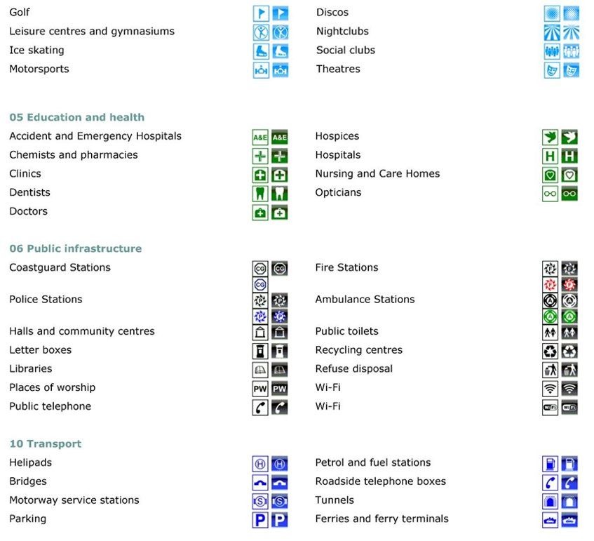
POINTS OF INTEREST – PRODUCT INFORMATION
August 2021

1.          Introduction
This product information document describes the main features of the product, suggests how customers
can use the data and explains how the data is supplied. Everyone reading this document will gain an
understanding of the key concepts of the data and the benefits an organisation can obtain from using it
within location-based applications.

The Points of Interest product is a comprehensive location-based directory of all public and privately-
owned businesses, educational institutions and leisure services in Britain. It contains over four million
records, sourced and quality-checked from over a hundred leading listing suppliers. It’s updated four times
a year, so you’ll always be working with current information.

For the public sector, Points of Interest lets you identify gaps in services and analyse changes in city centre
retail space over time. This helps you to maintain a quality environment for residents, shoppers and visitors.

With Points of Interest, you can:

•    Identify places by their use and function as well as their postal address or location. Each record also
     contains a telephone number, web address and brand, where appropriate.

•    See commercial addresses for organisations across Great Britain, including phone numbers and web
     URLs for major. Over 45% of Points of Interest records are businesses.

•    Use the detailed company classifications linked to addresses to conduct detailed competitor and site
     analysis for the potential location of your next high street outlet.

•    Access information on the following themes: accommodation, eating and drinking, commercial services,
     attractions, sport and entertainment, education and health, public infrastructure, manufacturing and
     production, retail, transport.

Media formats

Points of Interest customer orders are currently supplied via a Secure URL. The current size of a full supply
is about 1 Gb.

Glossary

Please refer to Annex D: Glossary as you work through this document.

Feedback

Ordnance Survey welcomes all feedback. If you have any comments or require further information, please
make contact using the details above.

OFFICIAL
                                                                                                      Page 4 of 37
© Ordnance Survey Ltd 2021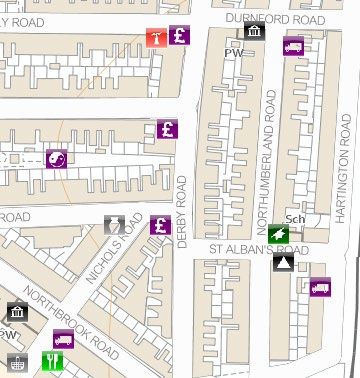
POINTS OF INTEREST – PRODUCT INFORMATION
August 2021

2.          About Points of Interest
The Points of Interest product is a comprehensive location-based directory of all public and privately
owned businesses, educational institutions and leisure services in Great Britain. It contains over four million
records, which are sourced and quality-checked from over a hundred leading listing suppliers. It’s updated
four times a year, so you’ll always be working with current information.

For the public sector, Points of Interest lets you identify gaps in services and analyse changes in city centre
retail space over time. This helps you to maintain a quality environment for residents, shoppers and visitors.

You can:

•    Identify places by their use and function as well as by their postal address or location. Each record also
     contains a telephone number, web address and brand, where appropriate.

•    See commercial addresses for organisations across Great Britain, including phone numbers and web
     URLs for major businesses. Over 45% of Points of Interest records are businesses.

•    Use the detailed company classifications linked to addresses to conduct detailed competitor and site
     analysis to help you identify the potential location of your next high street outlet.

•    Access information on the following themes: accommodation, eating and drinking, commercial services,
     attractions, sport and entertainment, education and health, public infrastructure, manufacturing and
     production, retail and transport.

As each feature is provided with a national grid coordinate, it can be visualised as points on a map using a
geographical information system (GIS).

Common applications for which customers are already using Points of Interest include:

•    Citizen information services
•    Distribution and provision of facilities and infrastructure
•    Emergency planning
•    Location-based services
•    Tourism

Each feature comes with a set of attributions that can be manipulated and analysed within a GIS or database
so that customers can customise the data and learn more about the facilities within their chosen geographic
areas.

2.1         Roles and responsibilities
Points of Interest is created and maintained by PointX, an independent company in the joint ownership of
Ordnance Survey and Landmark Information Group. Ordnance Survey is the sole ‘data only’ distributor for
Points of Interest.

PointX collects data from around 140 suppliers, including Ordnance Survey. It receives updates from these
suppliers on an ongoing basis. The suppliers are chosen for being the most authoritative source for the
particular type of feature they supply, and for the quality and completeness of their data. It should be noted
however, that for many types of features there are no absolute definitive source, nor can any list of the
types of features found in Points of Interest be said to be complete. Points of Interest therefore comes with

OFFICIAL
                                                                                                      Page 5 of 37
© Ordnance Survey Ltd 2021
POINTS OF INTEREST – PRODUCT INFORMATION
August 2021
a number of indicators as to the likely currency and positional accuracy of any given set, which should be
taken into consideration when using the data.
PointX runs verification checks, provides National Grid coordinates, and classifies each feature. The data is
sent quarterly to Ordnance Survey who distributes it to customers. Ordnance Survey manages the
customer relationship.
The suppliers are responsible for providing the data to PointX in a manner and timescale agreed between
them.
OFFICIAL
Page 6 of 37
© Ordnance Survey Ltd 2021POINTS OF INTEREST – PRODUCT INFORMATION
August 2021
3. Using Points of Interest
The primary use of Points of Interest is to allow identification of different facilities, resources or functions
within the built and natural environment.
The data can be used within a table format, such as a spreadsheet or a database, to create gazetteer or list
type applications that allow people to search for a particular facility or resource. These applications make
use of the attributes supplied for each feature and depend on the application system having a searching or
querying facility that the customer can supply with search criteria.
To achieve the greatest possible value from the data, it is best viewed and analysed within a GIS. The
combination of Points of Interest with topographic mapping gives context to the features, which cannot be
derived from using it within a table or spreadsheet. Depending on the functionality of the GIS, it also
provides the opportunity to:
• Group the features into other subsets of data.
• Combine the data with your own complementary datasets or with other Ordnance Survey products.
• Customise the appearance of the Points of Interest features to suit your requirements
(Ordnance Survey provides a suggested set of symbols, available from the product support page, to get
customers started).
• Extend the queries on the attributes by using a spatial element.
3.1 Viewing the data
Points of Interest can be displayed within a GIS by using the Easting and Northing coordinates to display
each feature’s geographic location as a point. The National Grid coordinates that accompany each feature
allows it to be displayed as a point, in its correct position with regards to the National Grid and any other
map based on the same reference system.
The simplest way to display the product is to render all points with a single colour and shape, as shown in
Figure 1, below. These can then be labelled with the classification code to understand what each point
represents. By providing the context of the physical environment within which the Points of Interest
features exist can add another dimension of meaning to the data. It allows a spatial understanding of the
features to develop.
Points of Interest is completely customisable in terms of the way you choose to symbolise the points. The
way in which the data appears on a screen is likely to be a combination of your wishes and the functionality
of the system being used to display the points.
OFFICIAL
Page 7 of 37
© Ordnance Survey Ltd 2021POINTS OF INTEREST – PRODUCT INFORMATION
August 2021
Figure 1: Points of Interest rendered with a single and simple symbology
Figure 2: Points of Interest rendered with category symbology
3.2 Styling the data
Most GIS have tools that provide options for rendering data on screen. Ordnance Survey has developed
sets of symbols to use with the Points of Interest dataset so that customers can render the data very
quickly. These are available to download from the product support page.
Using a symbol set that makes use of Category level of classification means that the viewer can understand
the information quickly. Comparing Figure 1 with Figure 2, which shows Points of Interest data rendered
with a set of the supplied symbols, it is possible to get an idea of the range and type of features that are in
this area without querying the attribution.
The symbol sets are supplied in:
• Black and white bitmaps
• Colour bitmaps
• TrueType font
OFFICIAL
Page 8 of 37
© Ordnance Survey Ltd 2021POINTS OF INTEREST – PRODUCT INFORMATION
August 2021
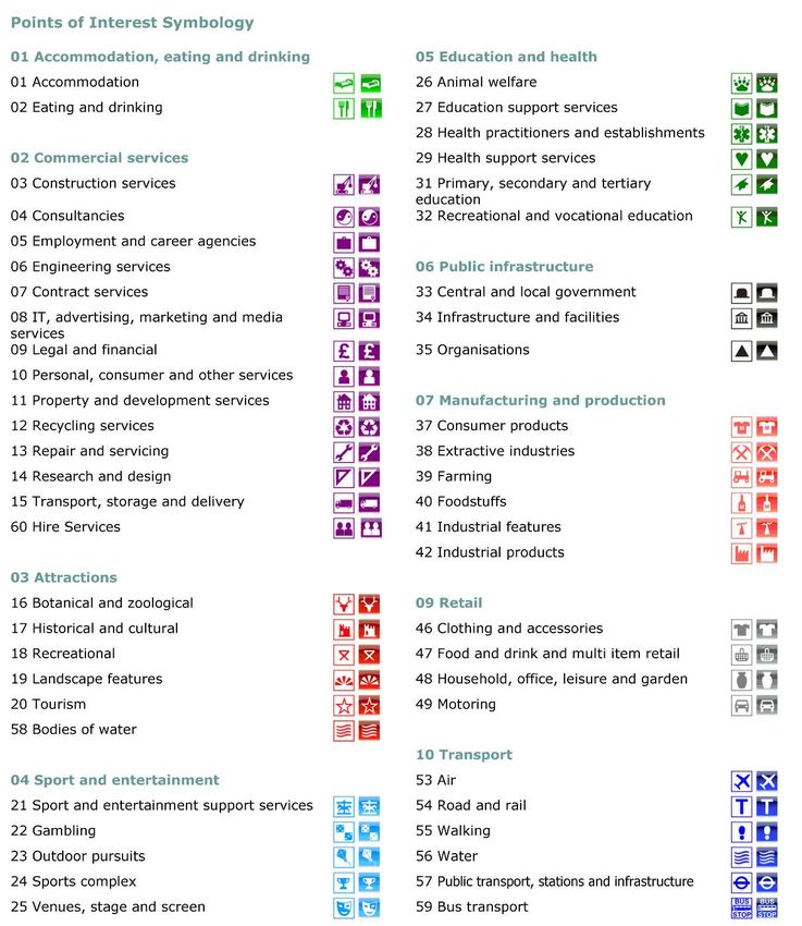
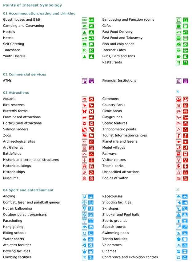
Refer to Annex B for the colour symbols. Table 2 illustrates the colour symbols used for each of the 52
Categories. Table 3 illustrates the additional colour symbols used for certain Classes. The symbols can be
downloaded from Ordnance Survey’s website.
3.3 Backdrop mapping
The real benefits of Points of Interest within a GIS can be seen when displaying the features over some
backdrop mapping. This adds real-world context to the features. Points of Interest features are best used in
combination with a large-scale product such as OS VectorMap Local, an example of which is used in Figure
3 below. This allows both clarity and the ability to derive additional value from both products. A slightly
smaller scale backdrop, such as OS VectorMap District, can also provide the necessary context. An
example is shown in Figure 4 below.
Figure 3: Points of Interest over OS VectorMap Local (1:3,000)
Figure 4: Points of Interest over VectorMap District (1:10,000)
OFFICIAL
Page 9 of 37
© Ordnance Survey Ltd 2021POINTS OF INTEREST – PRODUCT INFORMATION
August 2021
Whilst it is possible to view the data at any scale, the smaller the scale, the harder it is to see what real-
world feature the point represents. There are problems of points either being difficult to distinguish from
each other or, if they are set to enlarge as the map is zoomed out, they can disappear behind each other, as
shown in Figure 4.
OFFICIAL
Page 10 of 37
© Ordnance Survey Ltd 2021POINTS OF INTEREST – PRODUCT INFORMATION
August 2021
4. Classification
Classification provides structure to the data which helps when storing it. It provides a way of ordering the
data, a means of visualising it, and a way for customers to find the features they are interested in quickly.
Points of Interest has its own classification scheme with each feature assigned to a Class within the system.
The classification is central to the Points of Interest dataset as it provides a hierarchical structure to the
data that makes it efficient to store in a computer system and easier to search. It also provides a means of
subdividing the data so that customers can order only the features they want.
The classification was created by PointX. It is designed to be comprehensive, intuitive and easy to use. It
provides the necessary level of detail to be useful and flexible without being so complex that it becomes
difficult to use the product in applications. There are three levels of classification: Group, Category and
Class.
Level 1 comprises nine Groups and provides the broadest categorisation.
Level 2 comprises 52 Categories which are broken down into more than 600 Classes to form the third
level of the classification scheme. This is the most specific level of classification. The full classification is
given in Annex A. Over the life of the product, some Classes have been changed, added or merged with
other classes, which is why numbers are not sequential.
Having three levels of classification enables customers to make general searches. For example, at the Group
level, education and health, specific searches at the Category level, such as primary, secondary and tertiary
education, or specialist searches, such as special schools and colleges, at the Class level.
You can order Points of Interest at either the Group or the Category level. Features are allocated a
classification based on either:
• A classification provided by the original data supplier.
• Where no classification is provided, PointX uses its experience and understanding of the dataset itself,
or elements within it, to allocate a classification.
Classifications make it easy to use database or GIS tools to search, analyse and display features based on
their Class. When used in conjunction with the attribution, it is possible to compile, for instance, a list of
the names and addresses of estate agents within a given geographic area. In Figure 5 below, the
classification has been utilised to display all Bus Stops within an area using the classification code 10590732.
OFFICIAL
Page 11 of 37
© Ordnance Survey Ltd 2021POINTS OF INTEREST – PRODUCT INFORMATION
August 2021
Figure 5: Example of using classification to display symbology and perform spatial analysis
This breaks down as:
Group: 10 = Transport
Category: 59 = Bus Transport
Class: 0732 = Bus Stops
The structure of Points of Interest can be described as relational in nature. Each Group has one or more
Categories below it. Each Category in turn has one or more Classes related to it. This type of structure is
used extensively in database management technologies as it provides a way of storing the data in a way that
reduces the amount of space required and speeds up the retrieval of information. Having this classification,
therefore, provides an opportunity to store the data in an efficient way.
OFFICIAL
Page 12 of 37
© Ordnance Survey Ltd 2021POINTS OF INTEREST – PRODUCT INFORMATION
August 2021
5. Data measures and data sources
Supplier data is supplied to PointX in a wide variety of formats. Some of the data is supplied without grid
references and specific attribution, therefore efforts are made to supply this data. The success of this
identification is measured by the accuracy flags such as positional accuracy and match indicators.
5.1 Positional accuracy
Ordnance Survey data and specialised geocoding software is used to achieve positional accuracy and to
provide a confidence level indicator for each record. Data that cannot be given coordinates due to
insufficient location or address detail are not supplied in the Product. It is very important that customers
take the positional accuracy value of the feature into account when using it in applications.
The positional accuracy falls into one of the following categories:
• Positioned to the address or location, usually within the building footprint.
• Positioned to an adjacent address or location for non-addressable features.
• Positioned to the road within the address or location.
• Positioned within the geographical locality.
Typically, most records are positioned on or adjacent to the address or location of the feature. A very
small proportion of records are positioned to the road within the address or location, or within the
geographic locality of the feature. A positional accuracy code of 3 or 4 is used only for ATMs (cash
machines), WiFi hotspots and public telephones, where the data is sourced from a single authoritative and
non-duplicated source. Continuous efforts are made to improve the accuracy of the geocoding, as shown in
Table 1.
Table 1: Range of positional accuracy codes
Positional % of total dataset – Dec % of total dataset – Sept % of total dataset –
accuracy code 2010 2014 April 2019
1 71.75 79.87 86.22
2 27.21 19.28 13.66
3 0.84 0.70 0.07
4 0.20 0.15 0.05
Total 100.00 100.00 100.00
If the positional accuracy is stated as ‘1’, the coordinates should fall within the footprint of the real-
world feature in question, typically a building or structure.
Where the positional accuracy is stated as ‘2’, the coordinates will either be placed centrally in the
text that relates to the feature – and may be within the extent of the feature – or will be positioned close
to the true location of a part of the feature. In practice, it will probably be within 10 metres of either the
feature or an edge of the feature’s geographic extent, although this cannot be guaranteed.
OFFICIAL
Page 13 of 37
© Ordnance Survey Ltd 2021POINTS OF INTEREST – PRODUCT INFORMATION
August 2021
A positional accuracy of ‘3’ indicates that the coordinates are placed centrally on the correct road. As
road lengths vary and the central position could be very near or a long way from the true location on the
road, it is difficult to say exactly how far these instances might be shown from their true location. In the
majority, it is to be expected that the assigned coordinate could be up to a kilometre away, with a small
number being even farther.
A positional accuracy of ‘4’ means that the location assigned is in the correct geographic locality, such
as the right village or industrial estate, and that it has not been possible to locate to a specific relevant road.
Depending on how big the geographic locality in question is, the record’s true location could in reality be
up to a few kilometres from the reported coordinates.
5.2 USRN Match Indicators
Each Points of Interest feature is matched to the closest road by performing an attribution and spatial
match between the feature and OS MasterMap Highways Network. This results in each feature being given
a Unique Street Reference Number (USRN). The match accuracy between the Points of Interest feature
and the OS MasterMap Highways Network is determined from the USRN Match Indicator attribute. It is
again very important that customers take this match indicator value of the feature into account when using
it in applications.
If the match indicator is stated as ‘1’ the Points of Interest feature has been matched against the OS
MasterMap Highways Network using the Unique Property Reference Number (UPRN) from AddressBase
and the USRN.
Where the match indicator is stated as ‘2’, the feature has been matched spatially to the road which
appears in either the address detail or street name attributes. For more information on these individual
attributes please see the Technical Specification.
A match indicator of ‘3’ indicates that the USRN has been spatially matched to the nearest road in the
OS MasterMap Highways Network.
Please be aware that a match indicator of 3 may not necessarily be the access road to the feature.
5.3 Addressing
The data contains both addressable and non-addressable records. Structured address information is only
provided for those records that are addressable and can be successfully matched against AddressBase Plus.
AddressBase Plus contains current properties using addresses sourced from Local Authorities, Ordnance
Survey and Royal Mail for England, Wales and Scotland. The Unique Property Reference Number (UPRN)
is the unique identifier for every addressable location in Great Britain.
Records that have been successfully matched will have a UPRN. Attempts have been made to provide
address information where possible when not matched against AddressBase Plus.
OFFICIAL
Page 14 of 37
© Ordnance Survey Ltd 2021POINTS OF INTEREST – PRODUCT INFORMATION
August 2021
5.4 Unique referencing
Records have been attributed with both a TOID and TOID version that have been directly derived from
area features within OS MasterMap Topography Layer based on the grid reference of the feature. There
will be a number of features where a TOID value will not be provided because the feature does not sit
within the correct OS MasterMap Topography Layer polygon and these will have a TOID value of
Not Assigned and a TOID version of ‘0’.
5.5 Sources of data
There are two main sources of data that provide approximately 80% of the Points of Interest features. The
authoritative source for a type of feature is used to build the dataset where possible. Approximately
140 suppliers are used to create the dataset. Annex C lists all the suppliers and indicates their level of
contribution to the dataset.
5.6 Classification
PointX relies upon approximately 140 data suppliers to provide the initial classification of each of the
records. This is then used to allocate the appropriate class to the feature which can lead to examples
where different classes are applied to the same real-world feature, dependent upon the base classification
used by the different data suppliers. Part of the production process for the current product involves the
removal of multiple instances of what is believed to be the same feature, it is possible that individual
instances of what are, in fact, the same type of feature can be reported in different classes.
OFFICIAL
Page 15 of 37
© Ordnance Survey Ltd 2021POINTS OF INTEREST – PRODUCT INFORMATION
August 2021
Annex A: Classification system (v3.1)
The classification scheme has three levels of information:
• There are 9 Groups at the first level and each Group is numbered 01–07, 09, 10. Numbering is not
sequential.
• There are 52 Categories at the second level, numbered 01–60. Numbering is not sequential.
• There are over 600 Classes at the third level.
Customers can select Points of Interest from the Group and Category level.
01 Accommodation, eating and drinking
01 Accommodation
0003 Bed and breakfast and backpacker
0007 Self catering
accommodation
0002 Camping, caravanning, mobile homes, holiday
0008 Timeshare
parks and centres
0005 Hostels and refuges for the homeless 0009 Youth accommodation
0006 Hotels, motels, country houses and inns
02 Eating and drinking
0012 Banqueting and function rooms 0020 Fish and chip shops
0013 Cafes, snack bars and tea rooms 0025 Internet Cafes
0018 Fast food and takeaway outlets 0034 Pubs, bars and inns
0019 Fast food delivery services 0043 Restaurants
02 Commercial services
03 Construction services
0779 Building and component suppliers 0053 Glaziers
0045 Building contractors 0044 Metalworkers including blacksmiths
0046 Construction completion services 0054 Painting and decorating services
0047 Construction plant 0055 Plasterers
0048 Cutting, drilling and welding services 0056 Plumbing and heating services
OFFICIAL
Page 16 of 37
© Ordnance Survey Ltd 2021POINTS OF INTEREST – PRODUCT INFORMATION
August 2021
03 Construction services
0049 Demolition services 0057 Pool and court construction
0050 Diving services 0058 Restoration and preservation services
0051 Electrical contractors 0059 Road construction services
0778 Fencing and drystone walling services 0060 Roofing and chimney services
0052 Gardening, landscaping and tree surgery
services
04 Consultancies
0063 Architectural and building-related
0069 Image consultants
consultants
0064 Business-related consultants 0070 Interpretation and translation consultants
0065 Computer consultants 0071 Security consultants
0066 Construction service consultants 0072 Telecommunications consultants
0067 Feng shui consultants, furnishers and shop 0074 Traffic management and transport-related
fitters consultants
0068 Food consultants
05 Employment and career agencies
0075 Careers offices and armed forces
0078 Employment agencies
recruitment
0076 Domestic staff and home help 0079 Modelling and theatrical agencies
0077 Driver agencies 0081 Nursing agencies
06 Engineering services
0083 Aviation engineers 0089 Instrumentation engineers
0084 Chemical engineers 0090 Marine engineers and services
0085 Civil engineers 0091 Mechanical engineers
0086 Electrical and electronic engineers 0092 Pneumatic engineers
0087 Hydraulic engineers 0093 Precision engineers
0088 Industrial engineers 0094 Structural engineers
OFFICIAL
Page 17 of 37
© Ordnance Survey Ltd 2021POINTS OF INTEREST – PRODUCT INFORMATION
August 2021
07 Contract services
0095 Agricultural contractors 0102 Drain and sewage clearance
0096 Aircraft charters 0105 Linen hire and washroom services
0098 Catering services 0107 Office services
0100 Contract cleaning services 0108 Packers
0101 Display and window dressers 0109 Pest and vermin control
08 IT, advertising, marketing and media services
0114 Advertising services 0124 Internet services
0115 Artists, illustrators and calligraphers 0125 Literary services
0116 Computer security 0126 Mailing and other information services
0117 Computer systems services 0127 Marketing services
0118 Concert/exhibition organisers and services 0128 Plate makers, print finishers and typesetters
0119 Database services 0129 Press and journalism services
0120 Desktop publishing services 0130 Printing and photocopying services
0121 Electronic and Internet publishers 0131 Recording studios and record companies
0122 Film and video services 0133 Telephone, telex and fax services
0123 General computer services 0134 Television and radio services
09 Legal and financial
0135 Accountants and auditors 0138 Banks and building societies
0137 Auctioneers, auction rooms and valuers 0796 Franchise and holding company services
0141 Cash machines 0148 Fundraising services
0142 Cheque cashing 0149 Insurers and support activities
0795 Commodity dealers 0150 Mortgage and financial lenders
0143 Company registration and trademarks 0151 Pawnbrokers
0144 Copyright and patent 0811 PayPoint® locations
0145 Credit reference agencies 0829 Pension and fund management
0140 Currency conversion and money transfers 0154 Solicitors, advocates and notaries public
0146 Debt collecting agencies 0773 Stocks, shares and unit trusts
0147 Financial advice services
OFFICIAL
Page 18 of 37
© Ordnance Survey Ltd 2021POINTS OF INTEREST – PRODUCT INFORMATION
August 2021
10 Personal, consumer and other services
0823 Adult services 0174 Party organisers
0155 Astrologers, clairvoyants and palmists 0175 Personalisation
0158 Cleaning services 0177 Photographic services
0160 Customer service centres 0826 Printing on garments
0161 CV writers 0775 Sculptors, woodworkers and stonemasons
0162 Detective and investigation agencies 0818 Sewage Services
0112 Event Ticket Agents and Box Office 0822 Slimming clubs and services
0165 Funeral and associated services 0821 Spas
0156 Hair and beauty services 0179 Sports services
0167 Headquarters, administration and central
0776 Tailoring and clothing alteration
offices
0166 Historical research 0180 Tattooing and piercing services
0103 Hotel Booking Agencies 0182 Trophies and engraving services
0169 Introduction and dating agencies 0777 Vehicle breakdown and recovery services
0170 Lock, key and security services 0183 Vehicle cleaning services
0171 Message and greeting services 0185 Weather services
0173 Motoring organisations 0186 Wedding services
0774 Musicians, orchestras and composers 0188 Window cleaners
11 Property and development services
0189 Commercial property letting 0195 Property information services
0191 Estate and property management 0192 Property letting
0194 Property development services 0190 Property sales
12 Recycling services
0199 Clearance and salvage dealers 0200 Scrap metal dealers and breakers yards
0198 Rag merchants 0202 Waste paper merchants
0196 Recycling, reclamation and disposal
13 Repair and servicing
0204 Building repairs 0793 Shoe repairs
OFFICIAL
Page 19 of 37
© Ordnance Survey Ltd 2021POINTS OF INTEREST – PRODUCT INFORMATION
August 2021
13 Repair and servicing
0205 Electrical equipment repair and servicing 0210 Sports and leisure equipment repair
0206 Household repairs and restoration 0211 Tool repairs
0207 Industrial repairs and servicing 0212 Vehicle repair, testing and servicing
0209 Service industry equipment repairs
14 Research and design
0214 Design services 0217 Testing and analysis services
0216 Research services
15 Transport, storage and delivery
0218 Airlines and airline services 0224 Ferry and cruise companies
0219 Animal transportation 0225 Import and export services
0221 Container and storage 0227 Railway related services
0222 Courier, delivery and messenger 0228 Removals and shipping agents
0223 Distribution and haulage 0230 Taxi services
60 Hire services
0097 Boat hiring services 0104 Leisure equipment hirings
0110 Renting and leasing of personal and household
0270 Bouncy castles and inflatables hire
goods
0111 Sound, light and vision service and equipment
0159 Clothing hire
hire
0099 Construction and tool hire 0113 Vehicle hire and rental
03 Attractions
16 Botanical and zoological
0231 Aquaria and sea life centres 0236 Horticultural attractions
0232 Bird reserves, collections and sanctuaries 0237 Salmon ladders
0233 Butterfly farms 0239 Zoos and animal collections
0235 Farm-based attractions
OFFICIAL
Page 20 of 37
© Ordnance Survey Ltd 2021POINTS OF INTEREST – PRODUCT INFORMATION
August 2021
17 Historical and cultural
0244 Historic buildings including castles, forts and
0240 Archaeological sites
abbeys
0813 Art galleries 0246 Historical ships
0241 Battlefields 0248 Museums
0245 Historic and ceremonial structures
18 Recreational
0252 Commons 0254 Picnic areas
0253 Country and national parks 0255 Playgrounds
0814 Municipal Parks and Gardens
19 Landscape features
0257 Designated scenic features 0259 Trigonometric points
20 Tourism
0268 Information centres 0267 Sightseeing, tours, viewing and visitor centres
0263 Laseria, observatories and planetaria 0266 Theme and adventure parks
0264 Model villages 0269 Unspecified and other attractions
0265 Railways (heritage, steam and miniature)
58 Bodies of water
0804 Lakes and waters 0806 Tams, pools and meres
0805 Lochs and lochans 0807 Reservoirs
04 Sport and entertainment
21 Sport and entertainment support services
0271 Children's activity centres 0275 Funfair services
0273 Entertainment services 0276 Mobile discos
0274 Firework related services 0820 Motorsport services
OFFICIAL
Page 21 of 37
© Ordnance Survey Ltd 2021POINTS OF INTEREST – PRODUCT INFORMATION
August 2021
22 Gambling
0277 Amusement parks and arcades 0279 Bookmakers
0278 Bingo halls 0280 Casinos
0281 Pools Promoters
23 Outdoor pursuits
0282 Angling and sports fishing 0285 Parachuting and bungee jumping
0283 Combat, laser and paintball games 0286 Paragliding and hang-gliding
0321 Riding schools, livery stables and equestrian
0284 Hot air ballooning
centres
0770 Outdoor pursuit organisers and equipment 0287 Water sports
24 Sports complex
0289 Athletics facilities 0299 Shooting facilities
0290 Bowling facilities 0300 Ski infrastructure and aerial cableways
0291 Climbing facilities 0301 Snooker and pool halls
0292 Golf ranges, courses, clubs and professionals 0302 Sports grounds, stadia and pitches
0293 Gymnasiums, sports halls and leisure centres 0303 Squash courts
0294 Ice rinks 0304 Swimming pools
0297 Motorsport venues 0305 Tennis facilities
0298 Racecourses and greyhound tracks 0306 Velodromes
25 Venues, stage and screen
0825 Adult venues 0312 Nightclubs
0308 Cinemas 0314 Social clubs
0762 Conference and exhibition centres 0315 Theatres and concert halls
0311 Discos
05 Education and health
26 Animal welfare
0316 Animal clipping and grooming 0320 Pet cemeteries and crematoria
0317 Dog training 0322 Veterinarians and animal hospitals
OFFICIAL
Page 22 of 37
© Ordnance Survey Ltd 2021POINTS OF INTEREST – PRODUCT INFORMATION
August 2021
26 Animal welfare
0318 Horse training 0323 Veterinary pharmacies
0319 Kennels and catteries
27 Education support services
0324 Education authorities 0326 Examination boards
0325 Education services 0800 Secure units
28 Health practitioners and establishments
0780 Accident and emergency hospitals 0370 Hospices
0330 Alternative, natural and complementary 0371 Hospitals
0364 Chemists and pharmacies 0372 Mental health centres and practitioners
0365 Clinics and health centres 0342 Midwifery
0815 Day and Care Centres 0373 Nursing and residential care homes
0367 Dental and medical laboratories 0344 Optometrists and opticians
0368 Dental surgeries 0809 Parenting and childcare services
0335 Dental technicians 0345 Physical therapy
0337 Dieticians and nutritionists 0352 Speech therapists
0369 Doctors surgeries 0354 Surgeons and cosmetic surgeries
0333 Foot related services 0812 Walk-in centres
0340 Homeopaths
29 Health support services
0356 Ambulance and medical transportation
0106 Medical equipment rental and leasing
services
0357 Blood transfusion service 0361 Medical waste disposal services
0358 Counselling and advice services 0362 Pregnancy related services and help centres
0359 Health authorities 0363 X-ray services
31 Primary, secondary and tertiary education
0379 Broad age range and secondary state schools 0377 Independent and preparatory schools
0375 First, primary and infant schools 0801 Pupil referral units
OFFICIAL
Page 23 of 37
© Ordnance Survey Ltd 2021POINTS OF INTEREST – PRODUCT INFORMATION
August 2021
31 Primary, secondary and tertiary education
0376 Further education establishments 0380 Special schools and colleges
0381 Higher education establishments 0382 Unspecified and other schools
32 Recreational and vocational education
0384 Ballet and dance schools 0394 Language schools
0385 Beauty and hairdressing schools 0395 Martial arts instruction
0388 Diving schools 0396 Music teachers and schools
0389 Drama schools 0397 Nursery schools and pre- and after-school care
0390 Driving and motorcycle schools 0399 Sailing schools
0391 First aid training 0400 Sports and fitness coaching
0392 Flying schools 0403 Training providers and centres
06 Public infrastructure
33 Central and local government
0404 Armed services 0416 Local government
0419 Members of parliament and members of
0415 Central government
European parliament
0407 Coastguard stations 0422 Police stations
0408 Consular services 0424 Prisons
0409 Courts, court services and tribunals 0425 Probation offices and police support services
0411 Driving test centres 0426 Registrars offices
0412 Embassies and consulates 0417 Revenue and customs offices
0414 Fire brigade stations 0429 Social service activities
0830 Foreign country support activities 0431 Tribunals
0418 Job centres
34 Infrastructure and facilities
0453 Allotments 0459 Places of worship
0454 Cemeteries and crematoria 0461 Public toilets
0455 Drinking fountains and water points 0462 Recycling centres
0433 Electrical features 0440 Refuse disposal facilities
OFFICIAL
Page 24 of 37
© Ordnance Survey Ltd 2021POINTS OF INTEREST – PRODUCT INFORMATION
August 2021
34 Infrastructure and facilities
0437 Gas features 0442 Telecommunications companies
0456 Halls and community centres 0443 Telecommunications features
0457 Letter boxes 0444 Utility companies and brokers
0458 Libraries 0441 Waste storage, processing and disposal
0438 Meteorological features 0802 Wi-Fi hotspots
35 Organisations
0445 Animal welfare organisations 0448 Institutes and professional organisations
0816 Charitable organisations 0449 Political parties and related organisations
0769 Community networks and projects 0450 Religious organisations
0817 Conservation Organisations 0447 Sports clubs and associations
0446 Fan clubs and associations 0452 Youth organisations
07 Manufacturing and production
37 Consumer products
0464 Baby, nursery and playground equipment 0480 Footwear
0790 Bathroom fixtures, fittings and sanitary
0481 Furniture
equipment
0465 Beds and bedding 0482 Garden goods
0466 Brushes 0483 Giftware
0467 Candles 0485 Hobby, sports and pastime products
0468 Canvas goods 0487 Jewellery, gems, clocks and watches
0470 Carpets, flooring, rugs and soft furnishings 0488 Lampshades and lighting
0472 China and glassware 0489 Leather products
0473 Clothing, components and accessories 0490 Lingerie and hosiery
0785 Conservatories 0491 Luggage, bags, umbrellas and travel accessories
0471 Medals, trophies, ceremonial and religious
0474 Cookers and stoves – non-electrical
goods
0475 Cosmetics, toiletries and perfumes 0493 Musical instruments
0476 Curtains and blinds 0494 Photographic and optical equipment
0477 Cutlery and tableware 0479 Refrigeration and freezing appliances
OFFICIAL
Page 25 of 37
© Ordnance Survey Ltd 2021POINTS OF INTEREST – PRODUCT INFORMATION
August 2021
37 Consumer products
0478 Disability and mobility equipment 0495 Saunas and sunbeds
0486 Disposable products 0497 Tents, marquees and camping equipment
0782 Fireplaces and mantelpieces 0498 Tobacco products
38 Extractive industries
0500 Coal mining 0504 Sand, gravel and clay extraction and merchants
0501 Oil and gas extraction, refinery and product
0506 Stone quarrying and preparation
manufacture
0502 Ore mining 0507 Unspecified quarries or mines
39 Farming
0508 Animal breeders (not horses) 0514 Fruit, flower and vegetable growers
0509 Arable farming 0516 Horse breeders and dealers
0510 Bee-keepers 0517 Livestock farming
0511 Dairy farming 0518 Mixed or unspecified farming
0512 Fish and shellfish 0520 Poultry farming, equipment and supplies
0513 Forestry
40 Foodstuffs
0522 Alcoholic drinks 0525 Dairy products
0523 Animal feeds, pet foods, hay and straw 0526 Fish, meat and poultry products
0524 Baking and confectionery 0528 Milling, refining and food additives
0530 Catering and non-specific food products 0529 Non-alcoholic drinks
41 Industrial features
0531 Business parks and industrial estates 0537 Oast houses
0534 Energy production 0538 Pipelines
0535 Lighting towers 0542 Unspecified works or factories
0536 Lime kilns 0543 Water pumping stations
OFFICIAL
Page 26 of 37
© Ordnance Survey Ltd 2021POINTS OF INTEREST – PRODUCT INFORMATION
August 2021
42 Industrial products
0544 Abrasive products and grinding equipment 0577 Industrial coatings and finishings
0783 Access equipment 0580 Lifting and handling equipment
0545 Adhesives and sealants 0581 Lubricants and lubricating equipment
0546 Aeroplanes 0582 Marine equipment including boats and ships
0547 Agricultural machinery and goods 0583 Measurement and inspection equipment
0584 Medical equipment, supplies and
0548 Air and water filtration
pharmaceuticals
0585 Metals manufacturers, fabricators and
0549 Arms and ammunition
stockholders
0550 Bearing, gear and drive elements 0586 Moulds, dies and castings
0551 Bee-keeping supplies 0588 Office and shop equipment
0553 Bricks, tiles, clay and ceramic products 0589 Ovens and furnaces
0555 Cable, wire and fibre optics 0590 Packaging
0784 Car ports and steel buildings 0591 Paints, varnishes and lacquers
0557 Colours, chemicals and water softeners and
0594 Pesticides
supplies
0558 Cleaning equipment and supplies 0598 Printing-related machinery
0562 Concrete products 0599 Published goods
0563 Cooling and refrigeration 0600 Pumps and compressors
0765 Educational equipment and supplies 0601 Radar and telecommunications equipment
0564 Electrical components 0602 Road maintenance equipment
0565 Electrical motors and generators 0603 Ropes, nets and cordage
0566 Electrical production and manipulation
0604 Rubber, silicones and plastics
equipment
0567 Electronic equipment 0605 Seals, tapes, taps and valves
0568 Electronic media 0791 Shelving, storage, safes and vaults
0569 Engines 0606 Signs
0781 Fences, gates and railings 0607 Special purpose machinery and equipment
0571 Fertilisers 0609 Stationery, stamps, tags and labels
0572 Food and beverage industry machinery 0608 Textiles, fabrics, silk and machinery
0573 General construction supplies 0579 Tools including machine shops
0612 General manufacturing 0615 Vehicles
0574 General-purpose machinery 0613 Vehicle bodybuilders
OFFICIAL
Page 27 of 37
© Ordnance Survey Ltd 2021POINTS OF INTEREST – PRODUCT INFORMATION
August 2021
42 Industrial products
0575 Glass 0614 Vehicle components
0787 Waste collection, processing and disposal
0788 Glass fibre services
equipment
0616 Wood products including charcoal, paper, card
0576 Horticultural equipment
and board
0767 Ice 0617 Workwear
09 Retail
46 Clothing and accessories
0797 Baby and nursery equipment and children’s
0659 Jewellery and fashion accessories
clothes
0656 Clothing 0660 Lingerie and hosiery
0657 Footwear
47 Food, drink and multi item retail
0671 Alcoholic drinks including off-licences and
0668 Green and new age goods
wholesalers
0661 Bakeries 0669 Grocers, farm shops and pick your own
0662 Butchers 0670 Herbs and spices
0768 Cash and carry 0703 Livestock markets
0663 Confectioners 0705 Markets
0699 Convenience stores and independent
0672 Organic, health, gourmet and kosher foods
supermarkets
0665 Delicatessens 0819 Supermarket chains
0666 Fishmongers 0798 Tea and coffee merchants
0667 Frozen foods
48 Household, office, leisure and garden
0824 Adult shops 0683 Garden centres and nurseries
0712 Art and antiques 0684 Garden machinery and furniture
0674 Books and maps 0685 General household goods
0693 Camping and caravanning 0717 Gifts and cards
OFFICIAL
Page 28 of 37
© Ordnance Survey Ltd 2021POINTS OF INTEREST – PRODUCT INFORMATION
August 2021
48 Household, office, leisure and garden
0675 Carpets, rugs, soft furnishings and
0686 Hobby, sports and pastime products
needlecraft
0687 Leather goods, luggage and travel accessories
0714 Charity shops
including handbags
0676 China and glassware 0688 Lighting
0827 Comic books 0704 Mail order and catalogue stores
0828 Computer shops 0689 Music and video
0720 Computer supplies 0690 Musical instruments
0677 Cosmetics, toiletries, perfumes and
0718 Party goods and novelties
hairdressing supplies
0678 Craft supplies 0691 Pets, supplies and services
0679 Cycles and accessories 0724 Photographic and optical equipment
0700 Department stores 0763 Post offices
0701 Discount stores 0831 Potteries
0680 DIY and home improvement 0719 Second-hand goods
0721 Domestic appliances 0708 Shopping centres and retail parks
0722 Electrical goods and components 0725 Stationery and office supplies
0716 Florists 0710 Surplus goods
0682 Furniture 0726 Telephones and telephone cards
0766 Fuel distributors and suppliers 0694 Travel agencies
0764 Garages, garden and portable buildings
49 Motoring
0695 New vehicles 0697 Vehicle auctions
0696 Second-hand vehicles 0698 Vehicle parts and accessories
10 Transport
53 Air
0728 Airports and landing strips 0729 Helipads
OFFICIAL
Page 29 of 37
© Ordnance Survey Ltd 2021POINTS OF INTEREST – PRODUCT INFORMATION
August 2021
54 Road and rail
0730 Bridges 0737 Petrol and fuel stations
0733 Cattle grids 0740 Signalling facilities
0734 Fords and level crossings 0743 Viaducts
0735 Motorway service stations 0744 Weighbridges
0736 Parking
56 Water
0751 Aqueducts 0753 Moorings and unloading facilities
0754 Rivers and canal organisations and
0760 Ferries and ferry terminals
infrastructure
0752 Locks 0755 Weirs, sluices and dams
57 Public transport, stations and infrastructure
0731 Bus and coach stations, depots and
0758 Taxi ranks
companies
0794 London Underground entrances 0756 Tram, metro and light railway stations and stops
0738 Railway stations, junctions and halts 0761 Underground network stations
59 Bus transport
0732 Bus stops 0759 Hail and ride zones
OFFICIAL
Page 30 of 37
© Ordnance Survey Ltd 2021POINTS OF INTEREST – PRODUCT INFORMATION
August 2021
Annex B: Points of Interest symbology
Symbology: Categories
Table 2: Colour bitmap symbols for Points of Interest Categories
OFFICIAL
Page 31 of 37
© Ordnance Survey Ltd 2021POINTS OF INTEREST – PRODUCT INFORMATION
August 2021
Symbology: Additional Classes – colour bitmaps
Table 3: Colour bitmap symbols for selected Points of Interest Classes
OFFICIAL
Page 32 of 37
© Ordnance Survey Ltd 2021POINTS OF INTEREST – PRODUCT INFORMATION
August 2021
OFFICIAL
Page 33 of 37
© Ordnance Survey Ltd 2021POINTS OF INTEREST – PRODUCT INFORMATION August 2021 Annex C: Points of Interest provenance The following percentages are indicative only. They were correct as of August 2019 but are subject to change at each quarterly supply without notice. Provenance Contribution (%) Ordnance Survey 43.68% 118 Information 37.02% Department for Transport 8.86% Local Data Company 3.84% Wilmington Healthcare Ltd 1.22% Vocalink 1.13% Edubase 0.64% PayPoint 0.63% Department for Transport (Parking) 0.51% PointX 0.43% Additional Suppliers to Points of Interest (supplying
POINTS OF INTEREST – PRODUCT INFORMATION
August 2021

Additional Suppliers to Points of Interest (supplying
POINTS OF INTEREST – PRODUCT INFORMATION
August 2021

Annex D: Glossary
Glossary
                              The closeness of the results of observations, computations or estimates to
                              the true values or the values accepted as being true. Accuracy relates to the
Accuracy
                              exactness of the result and is the exactness of the operation by which the
                              result is obtained.
                              A blanket term used by Ordnance Survey to refer to all public
Administrative area           administrative areas, specifically local government management and
                              electoral areas.
American Standard Code
for Information Interchange   A 7-bit code for encoding a standard character set.
(ASCII)
                              A spatial extent defined by circumscribing lines that form a closed
Area
                              perimeter that does not intersect itself.
                              An attribute is a property of an entity, usually used to refer to a non-spatial
Attribute                     qualification of a spatially referenced entity. For example, a name or
                              descriptive code indicating what an entity represents or how it should be
                              portrayed.

Attribute code                An alphanumeric identifier code used in digital map data to describe each
                              feature in terms either of the object surveyed or its representation on the
                              map (or both).

Coordinates                   Pairs of numbers, such as an easting and a northing, expressing horizontal
                              distances along original axes. Alternatively, triplets of numbers measuring
                              horizontal and vertical distances.
Currency                      An expression of the up-to-dateness of data.
                              A specification that defines the order in which data is stored or a
Data format
                              description of the way data is held in a file or record.
Eastings                      See rectangular coordinates.
                              An item of detail within a map that can be a point and/or symbol, text or
Feature
                              line.

Field                         A specified part of a record containing a unit of data, such as the date of
                              digitising. The unit of data may be a data element or a data item. Every field
                              has a name and a predefined interpretation.

Geographical information      A system for capturing, storing, checking, integrating, analysing and
system (GIS)                  displaying data that is spatially referenced to the Earth. This is normally
                              considered to involve a spatially referenced computer database and
                              appropriate applications software.
                              The ratio between the extent of a feature on the map and its extent on the
Map scale                     ground, normally expressed as a representative fraction, such as 1:1250 or
                              1:10 000.

OFFICIAL
                                                                                                    Page 36 of 37
© Ordnance Survey Ltd 2021
POINTS OF INTEREST – PRODUCT INFORMATION
August 2021
Glossary
Name The proper name or label of an object (real world) or feature (object
abstraction). The descriptive name might consist of one or more text
strings or be an attribute of the object or object abstraction.
A unique referencing system that can be applied to all Ordnance Survey
National Grid maps of Great Britain (GB) at all scales. It is used by Ordnance Survey on all
post-war mapping to provide an unambiguous spatial reference in Great
Britain for any place or entity whatever the map scale. The National Grid is
defined by the OSGB36 spheroid.
Northings See rectangular coordinates.
Object (real world) A recognisable discrete part of the real world.
Origin The zero point in a system of rectangular coordinates.
The degree to which the coordinates define a point’s true position in the
Positional accuracy world, directly related to the spheroid and/or projection on which the
coordinate system is based.
The exactness with which a value is expressed, whether the value be right
Precision
or wrong.
Rectangular coordinates Also known as X-Y coordinates and as eastings and northings. These are
two-dimensional coordinates that measure the position of any point relative
to an arbitrary origin on a plane surface (for example, a map projection).
A measure of the ability to detect quantities. High resolution implies a high
Resolution degree of discrimination but has no implication as to accuracy. For example,
in a collection of data in which the coordinates are rounded to the nearest
metre, resolution is 1 metre, but the accuracy may be ± 5 metres or worse.
Data that includes a reference to a two- or three-dimensional position in
Spatial data
space as one of its attributes. It is used as a synonym for geometric data.
The physical medium on which digital data is transferred from one
Transfer medium
computer system to another. For example, Secure URL.
OFFICIAL
Page 37 of 37
© Ordnance Survey Ltd 2021You can also read