Political, legal and institutional frameworks for MSP in Cape Verde
←
→
Page content transcription
If your browser does not render page correctly, please read the page content below
Political, legal and institutional frameworks for MSP
                      in Cape Verde

                                    Daniela Casimiro

     FACULTY OF SCIENCES OF THE UNIVERSITY OF LISBON/FCIENCIAS ID
         MARE - MARINE AND ENVIRONMENTAL SCIENCES CENTRE

                          Brazil, Universidade Federal de Pernambuco
                                          Feb. 4-5, 2019
 This communication is a contribution to the PADDLE project, which has received funding from the European
 Union’s Horizon 2020 research and innovation programme under Grant agreement No 734271.
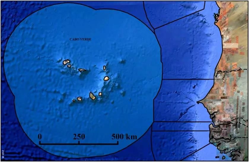
Cape Verde

With an emerged area of 4 033 km2 , Cape Verde EEZ / CS extends over an area
of 796 840 km2, that is almost 20 000 times larger than the terrestrial territory.
                           Source: Journal of Integrated Coastal Zone Management 10(3):243-253 (2010)

                               Brasil Workshop – Feb. 4-5, 2019                                         2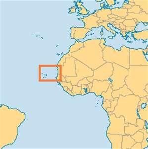
Maritime Borders

                                                   The Cape Verde – Senegal Maritime
                                                   Delimitation Treaty is a treaty in
                                                   which the two states agreed to
  Senegal          • 17 of February 1993
                                                   the delimitation of their maritime
                                                   boundary.

                                          Cabo Verde’s maritime boundary agreement with
                                          Mauritania was concluded in 2003 but is not yet in force.
                                          The agreement provides for a boundary extending
                                          approximately 160 nm in a north-south direction.
                                          According to Article 1, the “frontier” established by the
Mauritania       • 2003                   agreement is “a median line the points of which are
                                          equidistant from the nearest points on the baselines of
                                          the two countries.” The agreement establishes “a
                                          tripartite frontier point,” which is the northern terminus
                                          of the Cabo Verde-Senegal maritime boundary and the
                                          southern terminus of the boundary established in this
                                          agreement.

             Brasil Workshop – Feb. 4-5, 2019                                            3
Prospects for MSP in Cape Verde
The existing Institutional and Legal Frameworks enhancing MSP

                         Brasil Workshop – Feb. 4-5, 2019   4
Terrestrial Spatial Planning

 Legislation
Law No. 1/2006, of 13 February on Urban and Spatial Planning. (Amended by
Law No. 6/2010, of 21 June)

    provides a classification of the land comprised under the national territory
   and defines the basic principles for spatial planning and management.
    Includes Instruments of a special nature (higher juridical force) for spatial
   planning, in particular for coastal and protected areas.

Law- Decree No. 43/2010, of 27 September, approved the National Regulation
for Land and Urban Planning (RNOTPU).
    Defines the instruments to regulate territorial management development,
   planning, sectoral policies and special nature, such as land planning of:
   protected areas, touristic areas, coastal zone management and river basin
   areas.

                                Brasil Workshop – Feb. 4-5, 2019              5
Defines the strategic framework for the planning of
the national space.
Establishes the guidelines to be considered in
National regional and municipal planning.
Level Establishes the compatibility between the various
Territorial Management
sectoral policy instruments with a territorial impact,
Territorial Management
instituting, when necessary, instruments of a special
nature.
Instruments
System
Defines the strategic framework for
regional spatial planning in close
Regional coordination with economic and social
Level national development policies.
Establishes guidelines for municipal
planning.
Defines, in accordance with national and
Municipal regional guidelines and with its own strategic
development options, the land use regime and its
Level planning.
Management
and National Directive of Spatial Planning (DNOT)
development Regional Scheme of Spatial Planning (EROT).
territorial
instruments
Territorial Management
“Urban plans”:
Territorial Municipal Director Plan;
planning Urban Development Plan;
Instruments
instruments Detailed Plan.
Intermunicipal Plans.
Sectorial Plans of Spatial Planning :
- Transports;
Sectoral policy - Energy and geological resources;
instruments - Tourism;
- Trade and Industry,
- Environment, others.
Instruments of Spatial Plans for protected areas or other natural spaces of
a special cultural, historical or scientific value;
nature Spatial Plans for special touristic areas or industrial zones;
Coastal Zone Spatial Plans;
River basin Spatial Plans.
Instruments of special nature
Plans for the Management of Coastal Zones and the Adjacent Sea
Law-Decree No. 14/2016, of 1 March, approved the regulation on the preparation
and implementation of the Plans for the Management of Coastal Zones and the
Adjacent Sea (POOC_M).
This Plans are territorial management tools containing a set of actions for the
coastal zone management, which interventions are planned for the terrestrial
areas, referred as 'onshore', and areas called as 'adjacent sea areas’.
It specifies the territorial areas, boundaries, area of interventions and
management regime, including special areas and other classification of zones,
such as:
Special Tourism zones;
Risk Areas;
Protected Areas for Conservation of Nature and Biodiversity
• The area of intervention of the POOC_M comprises:
Terrestrial zone: corresponds to a band with a width of 1500 meters, counted from the
maximum high water line.
Adjacent sea areas: corresponds to a strip with a width of 3 nautical miles, counted from the
topographic zero.
Brasil Workshop – Feb. 4-5, 2019 8
Instruments of special nature
      Protected Areas Spatial Plan

Law Decree No. 3/2003, of 24 February, established the legal regime for the management of
Protected Areas.

     This Decree-Law establishes the legal regime in order to manage and control those areas
    needing a special protection, according to the importance of their biodiversity, natural
    resources, ecological function, socio-economic and touristic interest.
     Specifying the principles to be adopted in order to define and manage protected area and
    national parks according to the Capo verdean National Protected Areas' Programme.
     It lists a classification of the mentioned protected areas by island.
     The conservation objectives set forth in the Decree-Law may be materialized through a
    management plan for protected areas.

Law- Decree No. 44/2006, of 28 August, amended Law-Decree No. 3/2003 on Protected Areas
management

                Protected Areas Spatial              Management Plan
                         Plan
                                                 ≈     for Protected
                                                           Areas

                                    Brasil Workshop – Feb. 4-5, 2019                   9
Coastal and Marine Protected Areas
                                 Protected Area
               Island                                        Name PA /MPA          Terrestrial surface (Ha) Marine area (Ha) Total (Ha)
                                    Category
                             Reserva Natural           Costa da Fragata                              346,0             2347,0    2693,0
                             Reserva Natural           Ponta do Sino                                  96,0             5651,0    5747,0
                             Reserva Natural           Serra Negra                                   331,0             2296,0    2627,0
                             Reserva Natural (Marinha) Baía da Murdeira                              182,0             5925,0    6107,0
               Ilha do Sal   Reserva Natural           Rabo de Junco                                 154,0                0,0     154,0
                             Paisagem Protegida        Monte Grande                                 1309,0                0,0    1309,0
                                                       Salinas Pedra Lume e
                             Paisagem Protegida        Cagarral                                      802,0               0,0      802,0
                             Paisagem Protegida        Buracona-Ragona                               545,0               0,0      545,0
                             Reserva Natural Integral Ilhéu de Baluarte                                7,7              87,0       94,7
                             Reserva Natural Integral Ilhéu dos Pássaros                               0,8              38,0       38,8
                             Reserva Natural Integral Ilhéu de Curral Velho                            0,8              41,0       41,8
                             Reserva Natural           Ponta do Sol                                  465,0             283,0      748,0
                Boavista     Reserva Natural           Boa Esperança                                3631,0             379,0     4010,0
                             Reserva Natural           Morro de Areia                               2131,0             436,0     2567,0
                             Reserva Natural           Tartaruga                                    1439,0           13436,0    14875,0
                             Parque Natural            PN do Norte                                  8910,0           13137,0    22047,0
                             Monumento Natural         Ilhéu de Sal-Rei                               89,0               0,0       89,0
                             Reserva Natural           Casas Velhas                                  130,9            6495,2     6626,1
                             Reserva Natural           Lagoa Cimidor                                  51,1             406,3      457,4
                             Reserva Natural           Praia do Morro                                101,7             565,0      666,8
                  Maio
                             Paisagem Protegida        Salinas de Porto Inglês                       400,6             134,1      534,7
                             Paisagem Protegida        Barreiro e Figueira                          1080,8               0,0     1080,8
                             Parque Natural            Norte da Ilha de Maio                        4715,9           20886,6    25602,5
         Ilha de Santa Lúzia Reserva Natural (Marinha) Santa Lúzia                                  3427,0           27318,0    30745,0
            Ilhéu Branco e
                             Reserva Natura Integral                                                                 27837,0    28691,0
                  Raso                                 Ilhéu Branco e Raso                            854
             Ilha de Santo   Parque Natural Marinho    Cruzinha                                     4433,5             8054,4   12487,9
                  Antão      Paisagem Protegida        Pombas                                        311,9                0,0     311,9
         Ilha de São Nicolau Reserva Natural           Monte do Alto das Cabaças                    1325,0                0,0    1325,0

The National Network of Protected Areas is constituted by the following categories of protected areas under IUCN
categories:                 • Nature Reserves              • Natural Monument
                            • National Park                • Protected Natural Heritage                       10
                            • Natural Park                 • Sites of Scientific Interest
Ministry of Finance
Ministry of Sport
Ministry of Foreign Affairs and Communities
Institutional Ministry of Defence
Framework
Ministry of Justice and Labour
Government
Cape Verde
Ministry of Internal Administration
Ministry of Tourism and Transport
Ministry of Maritime Economy
Ministry of Industry, Trade and Energy
Ministry of Agriculture and Environment
Ministry of Education
Ministry of Family and Social Inclusion
Law-Decree No. 14/2018
Ministry of Culture and Creative Industries
15 Ministries Ministry of Health and Social Security
Ministry of Infrastructure,
Brasil Spatial
Workshop – Feb. Planning and Housing
4-5, 2019 11Cape Verde Institutional Framework for MSP
The Minister (…) directs the Ministry (…), which pursues assignments in
the fields of maritime policy, maritime economy and industry, marine
resources, fisheries, aquaculture, ports and maritime transport.
Ministry of Maritime
Economy The Minister of Maritime Economy proposes and implements, in
conjunction with the Minister for Foreign Affairs and Communities and
Deputy Prime Minister for Regional Integration, policy measures, actions
and programs for the planning and management of Cape Verde's relations
with all specialized agencies in fields of its intervention.
Government
The Minister (...) directs the Ministry (...), which pursues assignments in
agriculture, forestry, livestock, agro-industry, food safety, environment,
Ministry of water and sanitation.
Agriculture and
Environment The Minister of Agriculture and Environment proposes and executes, in
articulation with the Minister of Foreign Affairs and Communities, the
political measures, actions and programs for planning and
management of Cape Verde relations with all specialized bodies in the
fields of its intervention.
The Minister of Infrastructure, Spatial Planning and Housing runs the
Ministry of Infrastructure, Spatial Planning and Housing, which pursues
Ministry of the powers regarding public works, construction, shipbuilding,
Infrastructure, infrastructures, land use, planning territory and housing.
Spatial Planning and
Housing The Minister proposes, coordinates and promotes the policies of
cartography, geodesy, land registry and planning and urban
development
Brasil Workshop – Feb. 4-5, 2019 12Cape Verde Institutional Framework for MSP
Government
Ministry of
Ministry of Maritime Ministry of Agriculture
Infrastructure, Spatial
Economy and Environment
Planning and Housing
National Institution for Directorate General
Territorial Management for Marine Resources National Directorate of
(INGT) (DGRM) Environment (DNA)
Directorate General
for Maritime Economy
(DGEM)
National
Institute for Fisheries
Development (INDP)
Maritime and Port
Institut of Cape Verde
(IMP)
National Company for
Port Management S.A.
(ENAPOR) 13Cape Verde Institutional Framework for MSP
Ministry of Infrastructure, Spatial Planning
and Housing Ministry of Agriculture and Environment
Instituto Nacional de Gestão do Território -
INGT Direção Nacional do Ambiente - DNA
National Institute for Territorial Management National Directorate of Environment
The INGT is a personalized service of the The DNA is a central service of the Ministry of
State, with mission to pursue policies of: Agriculture and Environment with design
Planning and land use planning; functions, regulation, coordination, execution
• Urban development and housing; and direct support to the Minister, on the
• Land registry; environment, including:
• Geodesy; Prevention and impact assessment;
• Cartography; Nature conservation;
• Geology; Environmental information;
• Toponymy Follow-up of environmental quality.
• Management of the Spatial Data
Infrastructure of Cape Verde (IDE-CV).
DNA is the service with the authority functions
Contributing to growth and sustainable for the environmental impact assessment and
development in Cape Verde. protected areas.
14Cape Verde Institutional Framework for MSP
Ministry of Maritime Economy
Direção-geral da Economia Marítima – DGEM Direção-geral dos Recursos Marinhos - DGRM
Directorate General for Maritime Economy Directorate General for Marine Resources
The DGRM is the service responsible for carrying out
activities to support the development of fisheries and
The DGEM is the central service responsible for the aquaculture, as well as for articulating research,
design, planning, implementation and evaluation of valorization and sustainable exploitation of the
the economic maritime policies. national marine resources.
Develop and coordinate with the relevant
entities, the actions necessary for maritime and Ensure control of fishing activities;
coastal spatial planning; Ensure adequate exploitation of living marine
Develop policy measures to ensure the resources;
preservation, exploitation and use of marine Support the development of policies and
natural resources, aiming at the sustainability of programs on marine resources, fisheries and
the oceans in favor of the Blue Economy; aquaculture, including the management and use of
Prepare and propose the strategic plan for the marine living resources and the adoption of
development of the maritime economy, making measures to ensure their sustainable exploitation;
the country a maritime logistics platform in the Propose and disseminate legislative measures
Middle Atlantic. for the maritime economy, marine resources,
fisheries and aquaculture sector and ensure their
efficient and effective implementation. 15Cape Verde Institutional framework for MSP
Ministry of Maritime Economy
Instituto Nacional de Empresa Nacional de
Desenvolvimento das Pescas - Instituto Marítimo e Portuário - Administração dos Portos –
INDP IMP ENAPOR
National Institute of Fisheries Maritime and Port Institute National Company of Port
Development Administration
The IMP's main attributions are:
The INDP is responsible for:
Contribute to the definition of The ENAPOR, National
Conducting fisheries studies;
the country's maritime and port Company of Port Administration
Implementation of actions in
policy; of Cape Verde, is a public
various fields of Sciences related
Propose the definition of the company, Concessionaire of the
to fishing;
areas of maritime and port Ports of Cape Verde.
Propose recommendations
jurisdiction;
designed to improve the socio-
Ensure the articulation of port
economic results provided by the
planning plans with other
different fisheries, taking into
territorial planning instruments; ENAPOR's objective is the
account the policies, plans and
programs for the fisheries sector. Ensure coordination of the administration, management and
planning and strategic economic exploitation of the
development of the maritime-port country's ports, terminals and
system. zones of port jurisdiction,
Exploitation of fish stocks on a responsible also for its
sustainable basis, contributing conservation, planning and
to the development of the Apply and execute the policy for development
fisheries sector.
the Maritime and Port Sector. 16DGEM
Develops blue economy policies.
Develops and coordinates maritime and coastal
Ministry of spatial planning.
Maritime Licensing
Economy DGRM
Activities to support the development of fisheries
and aquaculture.
Licensing fisheries
M Ministry of DNA
S Agriculture
and
Coastal Protected Areas.
Marine Protected Areas.
Environment
P
Ministry of
INGT
Infrastructure, Planning and land use planning.
Spatial Cartography.
Planning and
HousingBlue Economy in Cape Verde
Brasil Workshop – Feb. 4-5, 2019 18Blue Economy in Cape Verde
In 2017, the Government of Cape Verde signed an agreement with the Food and
Agriculture Organization (FAO) to elaborate the National Investment Plan for
the Blue Economy (NBSAP) and the Programme for the Promotion of Blue
Economy (PROMEB).
Project: Support to the Implementation of the National Strategy on Blue Growth
in Cape Verde. Delivered under FAO’s Technical Cooperation Programme.
FAO assistance in Cabo Verde is shaped by the 2018-2022 FAO Country
Programming Framework (CPF), which is centered on the following medium-
term priority area(s):
Ensuring that the working population’s income increases through transformation
and growth in key economic sectors, including the Green Economy and the Blue
Economy.
Brasil Workshop – Feb. 4-5, 2019 19Blue Economy in Cape Verde
In 2018, the European Commission and the Government of the
Republic of Cabo Verde signed a new research and innovation
cooperation arrangement. The so-called Mindelo Arrangement
aims at strengthening and enhancing research and innovation
cooperation regarding Blue Growth.
Brasil Workshop – Feb. 4-5, 2019 20Blue Economy in Cape Verde
A number of subsectors related to the sea are considered relevant for the Cape Verde economy:
Maritime Transport, Ports, Logistics and Shipping;
Fishing, Aquaculture and Fisheries Industry;
Leisure, Sports, Tourism and Culture.
There is also another set of subsectors including shipbuilding and ship maintenance and repair, naval
and maritime authorities, maritime insurance and finance, energies, mineral resources and
biotechnology that, despite having an enormous potential, will take time to gain economic
relevance in the Cape Verde economic framework.
Source: HELM – PwC Economy of the Sea Barometer (Cape
Verde) Edition nº 1, December 2017 21Blue Economy in Cape Verde
Resolution No. 112/2015 - The Charter for the Fisheries and
promotion of Blue Growth in Cape Verde aims to: Aquaculture
Trade,
a) promote the sustainable development of oceanic Safety
valorization
and coastal areas; and food
safety
b) to minimize environmental degradation, loss of
biodiversity and the non-durable use of marine
resources; and Big
Services and
c) maximizing the economic and social benefits of scientific Strategic Environment
populations. research
Options
The Charter is the first component of the Cape Verde
Urban
engagement in favor of promoting blue growth. development
Aquatic
and coast
ecotourism
responsible
management Maritime
transport and
The Charter aims to strengthen the coherence of development
public policies linked to the maritime economy with port
the policies of other sectors.
Brasil Workshop – Feb. 4-5, 2019 22A Case Study:
Special Economic Zone of Maritime Economy in São
Vicente (ZEEEM - SV)
The ZEEEM-SV aims to take advantage of the sea and the geographical location of Cape
Verde, to develop an integrated maritime economy, through the creation of a chain of
industries and services connected to the sea.
Vision:
Transformation of Cape Verde into a maritime platform and logistics in the Middle Atlantic in the
medium and long term:
A country developed and competitive in the world economy.
São Vicente Island, modern island, international and at the service of the economy of the sea,
leveraging the development of the northern region of the country.
The implementation of ZEEEM-SV will have a major impact on the Cape Verde economy:
Job creation • Development of the national private sector
Industrial development • Diversification of economic growth
Increase in exports, • Internationalization of the Cape Verdean economy
Growth of Gross Domestic Product
Brasil Workshop – Feb. 4-5, 2019 23THANK YOU MARE CENTRE 24
You can also read