Using Information Obtained from SAR Data to Assess Flood Affected Areas in the Area of Bregovo, Bulgaria
←
→
Page content transcription
If your browser does not render page correctly, please read the page content below
Using Information Obtained from SAR Data to Assess Flood Affected Areas
                       in the Area of Bregovo, Bulgaria

                        Hristo NIKOLOV and Mila ATANASOVA, Bulgaria

   Key words: monitoring, flood, Sentinel-1, SAR data GRDH

   SUMMARY

   Flash flood events are type events that are difficult to predict, can develop rapidly and last for
   a short period of time. In the last years this type of incidents was observed in several areas of
   Bulgaria affecting human lives as well as infrastructure and landscape. This proves the need
   to have operational information about the extent of the damages caused by them delivered to
   the local authorities that could be used to mitigate the consequences and improve the decision
   making. In order to produce this information several prerequisites are needed such as updated
   data concerning the state of the impacted territories before and after the flood, a good DTM,
   the amount of the rain, etc. At present large share of this data are obtained routinely by the
   instruments onboard the satellites of the Copernicus program e.g. Sentinel 1 and 2, and are
   being freely distributed by ESA. Based on the said data the real situation of the land
   cover/land use, the soil moisture, the area of the water reservoirs is produced.
   In this paper we present results evidencing the flood event that took place during the first and
   second decade of March 2018. The flooding started on March 5th caused by fast snow melting
   in the mountainous region close to the Bregovo village located in the Northwest part of
   Bulgaria. The results are based on SAR data from Sentinel-1 mission having VV polarization
   and distributed in GRD format. During the processing additional data for elevation and land
   cover have been used as well. After classification of the resulting data we obtained
   information regarding the observed area before and few days after the peak of the event. The
   total inundated area was estimated to be about 700 ha.

Using Information Obtained from Sar Data to Assess Flood Affected Areas in the Area of Bregovo, Bulgaria (11007)
Hristo Nikolov and Mila Atanasova (Bulgaria)
FIG e-Working Week 2021
Smart Surveyors for Land and Water Management - Challenges in a New Reality
Virtually in the Netherlands, 21–25 June 2021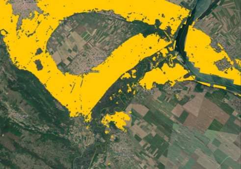
SUMMARY (bulgarian language)

   Неочакваните събития от тип наводнения са такива, които е трудно да се предвидят,
   могат да се развият бързо и продължават кратък период от време. През последните
   години този тип инциденти са наблюдавани в няколко области на България и те засягат
   човешки животи, както и инфраструктурни обекти и елементи на ландшафта. Това
   доказва необходимостта от наличие на оперативна информация за размера на
   причинените от тях вреди, която да бъде предоставена на местните власти и която да се
   използва за смекчаване на последиците от тях и подобряване качеството на вземаните
   решения. За да се получи тази информация, са необходими няколко предпоставки, като
   например актуализирани данни за състоянието на засегнатите територии преди и след
   наводнението, добър цифров модел на терена, количеството на падналия валеж и др.
   Понастоящем големи части от тези данни се получават рутинно от апаратурните
   комплекси на борда на спътниците от програма „Коперник“, като напр. Sentinel 1 и 2 и
   се разпространяват свободно от ESA. Въз основа на посочените данни се създава
   реалното състояние на земната покривка/земеползването, количеството на влага в
   почвата, площ на водоемите в района и др.
   В настоящата статия представяме резултати, доказващи наводнението настъпило през
   първото и второто десетилетие на март 2018 г. Това събитие започва на 5 март и бе
   причинено от бързото топене на снега в планинския район близо до село Брегово, което
   е разположено в северозападната част на България. Получените резултати се основават
   на данни за SAR от мисията Sentinel-1 във формат GRD с VV поляризация. По време на
   обработката са използвани и данни за надморска височина и земно покритие. След
   класификация на обработените данни получихме информация относно наблюдаваната
   зона преди и няколко дни след пика на събитието. На базата на нея общо залетите
   площи се изчисляват на около 700 ха

Using Information Obtained from Sar Data to Assess Flood Affected Areas in the Area of Bregovo, Bulgaria (11007)
Hristo Nikolov and Mila Atanasova (Bulgaria)
FIG e-Working Week 2021
Smart Surveyors for Land and Water Management - Challenges in a New Reality
Virtually in the Netherlands, 21–25 June 2021
Using Information Obtained from SAR Data to Assess Flood Affected Areas
                       in the Area of Bregovo, Bulgaria

                        Hristo NIKOLOV and Mila ATANASOVA, Bulgaria

       1. INTRODUCTION

   Most often in Bulgaria there are floods from the so-called rain river type. Floods caused by
   other means such as melting snow, riverbed congestion during ice drift, melting ice,
   destruction of dam walls, due to insufficient capacity or others accidents of hydraulic
   facilities, etc. are less common in the studied area. (Mardirosyan, 2020) In many cases it is
   observed a combined impact of the mentioned factors, one of which is almost always the
   torrential rain. Similar events had happened before in this region as result from rapid melting
   snow and torrential rains; torrential rains and impaired capacity or other accidents of
   hydraulic facilities, etc. The article presents a method for mapping of flooded areas using data
   from the radar Sentinel-1 mission based on their thematic processing and subsequent analysis.

   Figure 1. The flooded areas near the town of Bregovo after the river Timok come out of its
   riverbed. (bTV News, 2018)

Using Information Obtained from Sar Data to Assess Flood Affected Areas in the Area of Bregovo, Bulgaria (11007)
Hristo Nikolov and Mila Atanasova (Bulgaria)
FIG e-Working Week 2021
Smart Surveyors for Land and Water Management - Challenges in a New Reality
Virtually in the Netherlands, 21–25 June 2021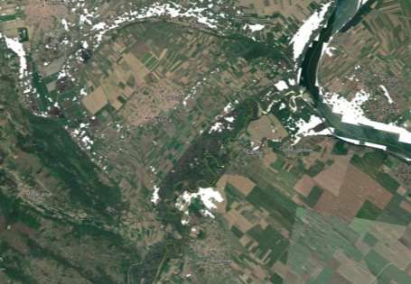
In the late winter of 2018 the Timok River in NW Bulgaria recorded extreme levels of
   flooding with water level reaching 5.6 meters higher than normal which resulted in flooding
   starting on March 5, 2018. The high waters receded a week later.
   Using SAR data from Sentinel-1 mission the authors delineated, analyzed and mapped the
   affected by the flooding event areas even under unfavorable weather conditions (high cloud
   cover). The rise of temperatures in early March 2018 led to active snowmelt and,
   consequently, rising water level of the rivers in the NW parts of the country (Timok and
   Danube). In the early hours on March 11th the river Timok comes out of its riverbed near the
   town of Bregovo. It was of importance for the local authorities to prepare rapid disaster maps
   that reflect the scope of the affected area and provide reliable source of information for
   managing this crisis situation. In this specific case the radar images from Sentinel-1 turned out
   to be very suitable since their acquisition is independent of the clouds presence and their
   thickness.

       2. DATA AND APPLIED PROCESSING METHOD

   To study this flooding event the authors processed a set of Sentinel-1 data products from
   descending and ascending orbits downloaded from the official ESA repository. The data were
   registered in VV polarization, preprocessed in GRD format which provides the intensity
   values of the amplitude of the backscattered radar signal. All SAR scenes used in the
   processing covered the area surrounding the village of Bregovo (see Fig. 2). The main
   software used for their processing was SNAP applying a verified procedure to radiometrically
   correct for terrain effects and to calibrate the intensity values which is required to prepare
   Sentinel-1 data for flood mapping analysis. (Atanasova, 2019) After that applied was a
   reclassification technique to assess the flooded areas in the mentioned study area.

       2.1 Data used

   In the table below listed are used SAR data products. The dates of the used data products were
   selected in such a manner to allow studying the development of whole event and its
   consequences. The time period include data for the weeks before the flood, for the period
   when the flood was at its peak, and for the period when the water receded.

   Table 1 Dates of the SAR data used relatively to the flooding event.

               Date                 Type of orbit
        February 27th 2018         Descending                               Pre-event
        March 6th 2018             Descending                                 Event
        March 18th 2018            Descending                               Post-event
        March 1st 2018             Ascending                                  Event
        March 7th 2018             Ascending                                  Event
        March 13th 2018            Ascending                                Post-event
        March 19th 2018            Ascending                                Post-event

Using Information Obtained from Sar Data to Assess Flood Affected Areas in the Area of Bregovo, Bulgaria (11007)
Hristo Nikolov and Mila Atanasova (Bulgaria)
FIG e-Working Week 2021
Smart Surveyors for Land and Water Management - Challenges in a New Reality
Virtually in the Netherlands, 21–25 June 2021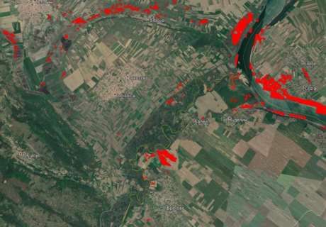
Using these seven data products we were able to map the changes in the flooded areas
   surrounding the village of Bregovo and its neighborhood for the indicated period.

       2.2 Pre-processing

   Since we had to process all the input data sets by one and same manner a processing graph
   was created (see Fig.2) and a batch process was executed. As a result we obtained seven
   processed images containing the amplitude of the backscattered from the ground surface radar
   signal. Those images were used to make the flooded areas delineation.

   Figure 2. Processing graph used to obtain information from SAR data.

   As the used auxiliary data are only from the region of Bulgaria we narrowed our study to
   areas that are on its territory. This why after corrections for the geometrical position of the
   satellite with the precise
   In order to focus on the studied region and to decrease the processing time we extracted from
   the whole scene only the areas that are within the borders of Bulgaria. After this procedure the
   size of the input data resulted to be much small. The product that covered only in the area of
   interest was created by sub-setting the original data using the latitude/longitude values of the
   four corners for the needed image. (see Fig.3)

   To ensure the quality of the final product the geolocation was taken as next step at which
   taken into account was the orbital position of the satellite and obtained were the orbit state
   vectors which were used in final geocoding of the resulting images. Next, an essential
   procedure that enables correct quantitative comparison of the results from multiple products is
   needed which removes the internal noise of the satellite instrument. Other necessary step is to
   normalize the backscattered amplitude values in the processed image. A specific feature that
   is present in the radar images is so-called “salt and pepper” effect which is caused by the
   different dielectric properties and orientation of the studied ground objects. This undesirable
   effect has to be removed by applying an appropriate filtering procedure. In order to be able
   properly to map the Earths’ surface objects imaged by SAR instrument at the end of the
   processing a geocoding procedure is executed to transform the SAR images having a radar
   geometry into single UTM coordinate system, Zone35N, WGS84.

Using Information Obtained from Sar Data to Assess Flood Affected Areas in the Area of Bregovo, Bulgaria (11007)
Hristo Nikolov and Mila Atanasova (Bulgaria)
FIG e-Working Week 2021
Smart Surveyors for Land and Water Management - Challenges in a New Reality
Virtually in the Netherlands, 21–25 June 2021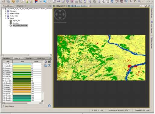
Figure3. Location of the excerpts from SAR data covering the studied flooded region –
   ascending and descending orbits.

       2.3 Flood assessment

   Since the main task is to establish the size of the flooded area in the region where the Brogovo
   town is located we had to process additionally the produced calibrated amplitude backscatter
   values which exhibit low values for water bodies and ground surface with high values for the
   soil moisture. The simplest approach is to set a threshold based on sampling pixels in and

Using Information Obtained from Sar Data to Assess Flood Affected Areas in the Area of Bregovo, Bulgaria (11007)
Hristo Nikolov and Mila Atanasova (Bulgaria)
FIG e-Working Week 2021
Smart Surveyors for Land and Water Management - Challenges in a New Reality
Virtually in the Netherlands, 21–25 June 2021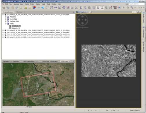
Figure 4. Elevation from SRTM mission with 30 m resolution.

   around well-known rivers (in the studied region there are large two rivers) and water bodies
   (two water reservoirs) for dates before the event and this manner to leave only the pixels for
   those areas above this value. In order to increase the accuracy not only the established
   threshold value was used, but also additional data for the elevation (see Fig.4) and for the land
   cover were used (see Fig. 5). The information from the elevation image band was used to
   classify only those pixels that are found in the plains and not in the mountains and high hills.
   The information from the land cover image band was used to further eliminate the water
   bodies that were identified as such by visual interpretation by human expert and this manner
   the final accuracy was increased too.

       3. RESULTS

   Before the start of the main flooding event in the studied region a precursor of it was observed
   on the first of the images used to form the time series. On Figure 6 visible are the areas
   outside the state border of Bulgaria where large discontinuous zone was detected in the SAR
   images as flooded or being overwetted by the fast melting of show in the mountain regions of
   the Timok rivershed.

Using Information Obtained from Sar Data to Assess Flood Affected Areas in the Area of Bregovo, Bulgaria (11007)
Hristo Nikolov and Mila Atanasova (Bulgaria)
FIG e-Working Week 2021
Smart Surveyors for Land and Water Management - Challenges in a New Reality
Virtually in the Netherlands, 21–25 June 2021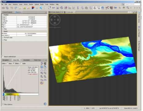
Figure 5. Land cover band used in SAR data interpretation.

        Figure 6. Processed SAR image from descending orbit dated February 27th 2018 (a week
                                  before the studied flooding event).

Using Information Obtained from Sar Data to Assess Flood Affected Areas in the Area of Bregovo, Bulgaria (11007)
Hristo Nikolov and Mila Atanasova (Bulgaria)
FIG e-Working Week 2021
Smart Surveyors for Land and Water Management - Challenges in a New Reality
Virtually in the Netherlands, 21–25 June 2021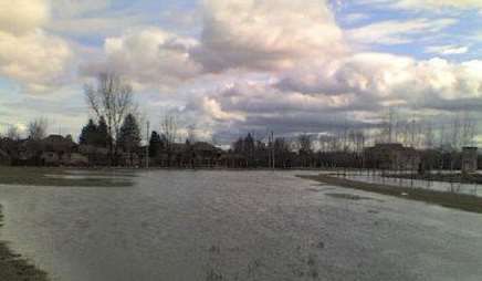
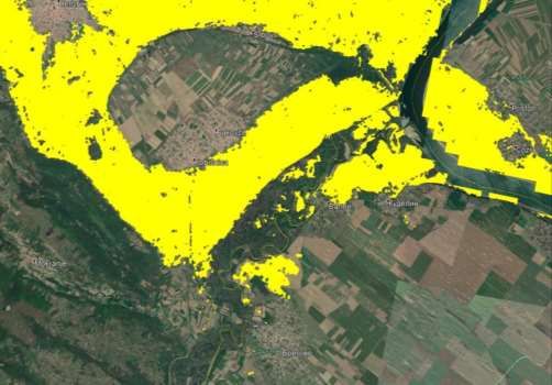
The peak of the flooding inside the territory of Bulgaria is clearly visible on the figures 7 and
8. The sizes of the areas registered as flooded on both images coincides although the former is
from descending orbit (March 6th 2018) and the latter is from ascending one (March 7th 2018)
with difference one day only. This evidenced the fact that the imagining geometry during data
acquisition by the SAR instrument does not influence the final outcomes of the processing.
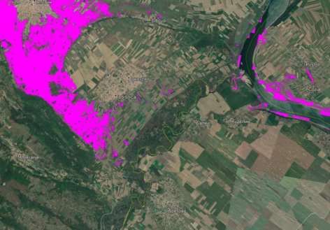
From the SAR images registered two weeks later the size of the zones detected as flooded
ones is much smaller which gives grounds to assert that the water receded from the affected
region. This is evidenced on the figures 9 and 10.
Figure 7. Flooded areas as detected by SAR from descending orbit on March 6th 2018 when
the flood is at its peak.
Using Information Obtained from Sar Data to Assess Flood Affected Areas in the Area of Bregovo, Bulgaria (11007)
Hristo Nikolov and Mila Atanasova (Bulgaria)
FIG e-Working Week 2021
Smart Surveyors for Land and Water Management - Challenges in a New Reality
Virtually in the Netherlands, 21–25 June 2021Figure 8. Flooded areas as detected by SAR from ascending orbit March 07th 2018 when the
flood is at its peak.
Figure 9. Decrease of the flooded plots – descending orbit March 18th 2018.
Using Information Obtained from Sar Data to Assess Flood Affected Areas in the Area of Bregovo, Bulgaria (11007)
Hristo Nikolov and Mila Atanasova (Bulgaria)
FIG e-Working Week 2021
Smart Surveyors for Land and Water Management - Challenges in a New Reality
Virtually in the Netherlands, 21–25 June 2021Figure 10. Decrease of the flooded plots – ascending orbit March 19th 2018. CONCLUSION In this paper presented were the results obtained from processing SAR data in order to produce information on the extent and temporal behavior of a flooding event which caused damages to several homes and dykes along the Timok river in the NW region of Bulgaria. This is good example of the fact that such events are crossing borders and is evidenced by the results shown here that a week before the disaster in the studied region similar situation due to high waters was taking place at the territory of Serbia. The method applied in this study was proved as reliable tool to deliver reliable information with regard to flooding events to the national and local authorities as well as to the wider public. It needs to be highlighted that the used technique to extract information from SAR data is less affected by the weather conditions than other remotely sensed data. Other benefit of it is that the revisiting time of the satellite instrument is relatively high (every 6 days) which gives possibility to create products at the same time intervals. ACKNOWLEDGEMENTS This work has been prepared under the contract No D01-161/28.08.2018 (Project "National Geoinformation Center (NGIC)" financed by the National Roadmap for Scientific Infrastructure 2017- 2023. Using Information Obtained from Sar Data to Assess Flood Affected Areas in the Area of Bregovo, Bulgaria (11007) Hristo Nikolov and Mila Atanasova (Bulgaria) FIG e-Working Week 2021 Smart Surveyors for Land and Water Management - Challenges in a New Reality Virtually in the Netherlands, 21–25 June 2021
REFERENCES

   Atanasova M., Nikolov H. (2019) The use of data from Sentinel-1 and Sentinel-2 in practice.
   Geomedia Magazine, January 1-February, 2019, ISSN: 1313-3365, 30-31

   bTV      News,     2018,    https://btvnovinite.bg/bulgaria/bezsanna-nosht-v-bregovo-zaradi-
   pridoshlite-vodi-na-timok.html

   Mardirosyan G. (2020) Natural disasters and ecological catastrophes, Publ. House ”Acad. M.
   Drinov” , Sofia

   BIOGRAPHICAL NOTES
   Associate professor Mila Atanasova-Zlatareva at the Department of Geodesy
   Since 1998, she has experience in involved in the processing and analysis of GNSS data,
   coordinate systems and transformations. In October 2013 she obtained a PhD degree on thesis
   “Transformations models in contemporary geodetic coordinate systems”. Her scientific
   interests and research tasks are focused on the study of the geodynamic processes and
   deformations of the Earth's crust for the territory of Bulgaria and the Balkan Peninsula; This
   includes determination of plate motions, deformation analysis and analyzed and monitoring of
   landslide processes through the InSAR method. Up to now she has 65 publications.

   CONTACTS
   Associate Professor Mila Atanasova-Zlatareva, PhD
   National Institute of Geophysics, Geodesy and Geography
   Bulgarian Academy of Sciences
   Acad. G. Bonchev Street, Bl. 3
   1113 Sofia
   BULGARIA
   Tel. + 359 2 979 33 54
   Email: mila_at_zl@abv.bg, mila.at.zl.@gmail.com

   BIOGRAPHICAL NOTES
   Assistant professor Hristo Nikolov.
   He started his scientific career in 1991 and since than he has focused his research interest in
   thematic data processing of remotely sensed data from different sources – satellite
   observations, airborne sensors and in-situ networks. During the years he gained vast
   experience in data handling and geomatics in the framework of several nationally and
   internationally funded projects. His PhD thesis targeted machine learning methods for data
   classification. Recently he is working on data fusion of optical and SAR data in order to
   obtain reliable operational information about the current status of the land cover. He is author
   of more than 80 scientific publications and conference papers.

   CONTACTS

Using Information Obtained from Sar Data to Assess Flood Affected Areas in the Area of Bregovo, Bulgaria (11007)
Hristo Nikolov and Mila Atanasova (Bulgaria)
FIG e-Working Week 2021
Smart Surveyors for Land and Water Management - Challenges in a New Reality
Virtually in the Netherlands, 21–25 June 2021
Associate Professor Hristo Nikolov, PhD
   Space Research and Technology Institute
   Bulgarian Academy of Sciences
   Acad. G. Bonchev Street, Bl. 1
   1113 Sofia
   BULGARIA
   Tel. + 359 2 979 24 58
   Email: hristo@stil.bas.bg

Using Information Obtained from Sar Data to Assess Flood Affected Areas in the Area of Bregovo, Bulgaria (11007)
Hristo Nikolov and Mila Atanasova (Bulgaria)
FIG e-Working Week 2021
Smart Surveyors for Land and Water Management - Challenges in a New Reality
Virtually in the Netherlands, 21–25 June 2021
You can also read