EU Platform Mapping Broadband services - Seminario: "Mappare la banda larga: Miglioramento dei servizi e innovazione" - Maps Agcom
←
→
Page content transcription
If your browser does not render page correctly, please read the page content below
EU Platform Mapping Broadband services
     Seminario: "Mappare la banda larga:
   Miglioramento dei servizi e innovazione"
                       Roma 21 Maggio, 2018
       Autorità per le Garanzie nelle Comunicazioni (AGCOM)
           Sala Angrisani – Via Isonzo 21/B, 00198 RM
                           h. 9.15 – 13.15

              Guido Acchioni: DG CONNECT B5
            Investment in high capacity networks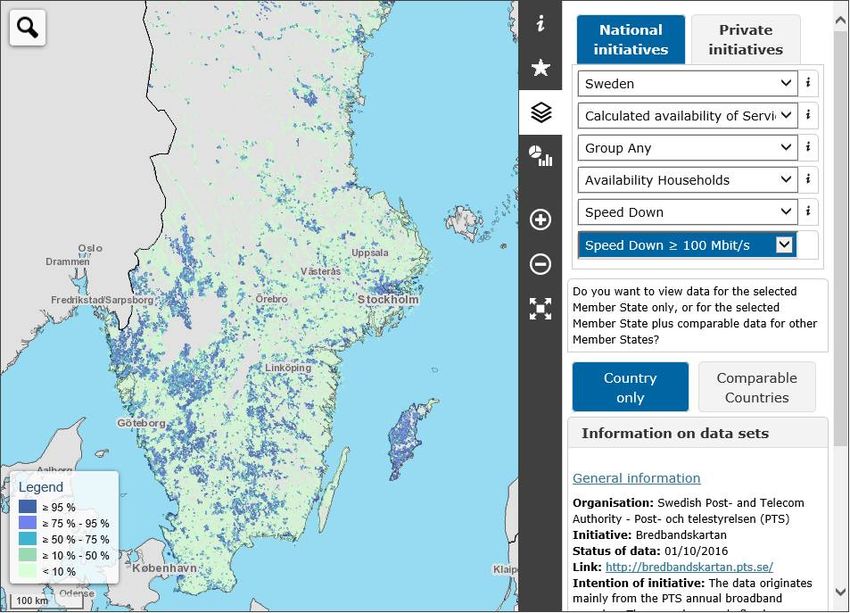
EU plaftorm
 mapping of fixed and mobile
Broadband Services in Europe
        (SMART 2014/0016)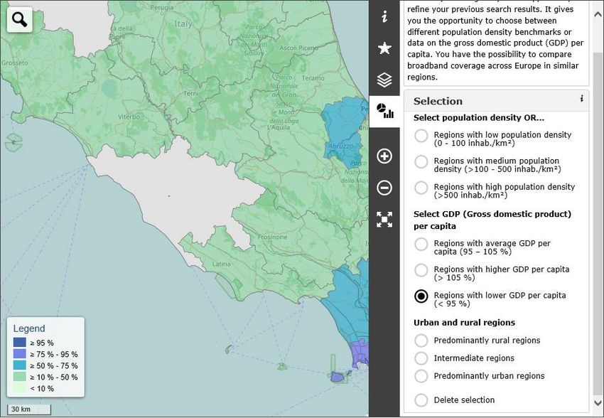
Why mapping at EU level?
•  Current Commission capacity to map in Europe is a combination of
   various sources.
    • Annual report on Broadband Coverage in Europe in measuring
       progress with respect to the broadband coverage targets set out in the
       Digital Agenda (ad-hoc studies).
    • At national and regional levels, mapping is increasingly based on
       dedicated IT systems - often offering online platforms open to the
       public. Key part for the development of the NGN plans (ex-ante
       conditionality in the framework of ESIF) and individual broadband
       rollout projects.
Drawbacks:
• Data is meaningful and reliable only at national/EU level, and for overall
   policy purposes;
• Data does not support programming or comparison at regional/local level
• Data not useful for state aid purposes (not prospective investments)
• Data not sufficient to measures VHC performance (only download speeds)
• …                                                                          3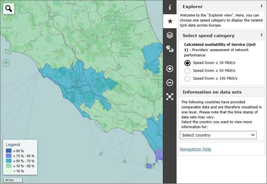
Mapping broadband services:
towards an EU integrated platform
The Broadband mapping project (SMART 2014/0016) aims to :
aggregate measurements of connectivity of quality of service (QoS) and
quality of experience (QoE) connectivity. (TUV Rheinland Consulting will
develop this IT project until 2018).
facilitate information exchange and benchmarking between Member States.
The portal will be complementary to the mapping activities of EUMS and EEA
(Ministries, NRAs, regional agencies, users and consumers organisations etc.)
and will also gather private crowdsourcing QoS/QoE actions.
A Technical Review Panel made up of representatives from various data
providers and international experts assists the European Commission. Its
includes representatives from MS (IT, IE, FR), from NRAs (AGCOM,
ANCOM,UKE) and from BEREC Working Group on Network Neutrality (Ofcom,
BNetzA) BEREC Mobile Coverage WG (ARCEP). 4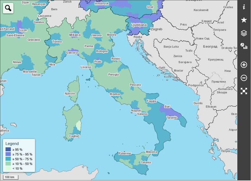
Explorer view
QoS-1 Speed Down ≥ 30 Mibt/s

                               •   QoS-1 provided: AT, BE, BG, DE,
                                   DK, ES, FI, FR, HR, HU, IS, IT,
                                   LU, NL, PL, SI, SK, SE, UK

                               •   not displayed in this view, BG,
                                   ES, HR, HU, NL, PL, SK, UK, since
                                   they are grouped according to a
                                   different methodology

                               •   data shown was collected
                                   between 2016 and 2017

                               •   further updates of 2017 data are
                                   expected

                                                                  5
QoS-1 Speed Down ≥ 30 Mbit/s   Data: AGCOM, 30th Oct 2017, NUTS3

   Explorer view

                                                                   6
QoS-1 Speed Down ≥ 30 Mbit/s

  Explorer view

                  Data: AGCOM, 30th Oct 2017, NUTS3   7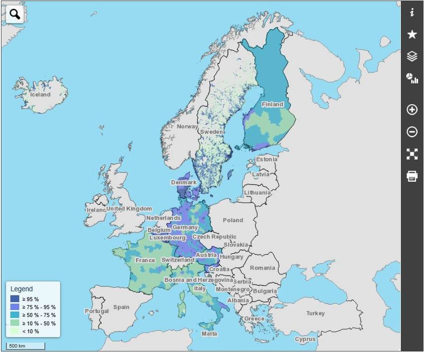
QoS-1 Speed Down ≥ 30 Mbit/s, medium population density

    Analysis view                                  Selection of NUTS3 areas by
                                                   different level of population
                                                   density:
                                                   •   low: 0 - 100 inhabitants /
                                                       km²
                                                   •   medium: 101 – 500
                                                       inhabitants / km²
                                                   •   high: > 501 inhabitants /
                                                       km²

                                                                             8
 Data: AGCOM, 30th Oct 2017, NUTS3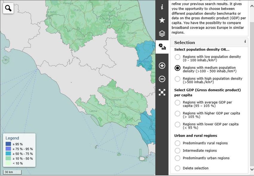
QoS-1 Speed Down ≥ 30 Mbit/s, lower than average GDP

   Analysis view
                                                       Selection of NUTS 3 areas
                                                       based on GDP per
                                                       capita:
                                                       • 95%-105% of average
                                                         GDP
                                                       • > 105% of average
                                                         GDP
                                                       • < 95% of average GDP

                                                       • filter set on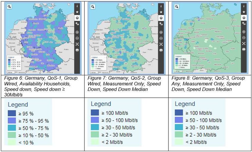
QoS-1 Speed Down ≥ 30 Mbit/s, lower than average GDP
                                                        Selection of NUTS3 areas
                                                        based on urbanization level
   Analysis view                                        •   predominantly urban areas
                                                            (at least 50% of population
                                                            lives in clusters with
                                                            >1500 inhabitants/km²)
                                                        •   intermediate areas (1500
                                                            inhabitants/km²;
3 categories serving different purposes and objectives
Wha Theoretical network performance of existing infrastructure
t (coverage, no pure infrastructure data)
QoS-1:
Calculated Wired: Assessment /
availability calculation / marketed speeds Wireless: Radio field planning
Ho
of service by provider / geodata-based
w
simulation models / prediction
tools
Wha Provision of service measured at the Customer Premises Equipment
QoS-2: t (CPE), e.g. routers, mobile devices 9EG (Samknows in UK)
Measured
Wired Wireless
provision
Ho Measurement through panel Measurement through drive tests
of service
w probes with filter to exclude end or speed tests to exclude end
user´s environment user´s environment
Wha
Actual user’s experience when using Internet Access Service (IAS)
QoS-3: t
Measured
Wired Wireless
experience
Ho Measurement via online speed Measurement via online speed
of service 11
w tests including end user’s tests including end user’s
environment environmentDifferences between QoS groups
Data sources,
QoS-1: German Ministry
QoS-2: German NRA
QoS-3: M-Lab
Legends:
• QoS-1 focuses on
percentage availability
of one speed category
• QoS-2 & 3 focus on
measured
throughput values,
e.g. average, median
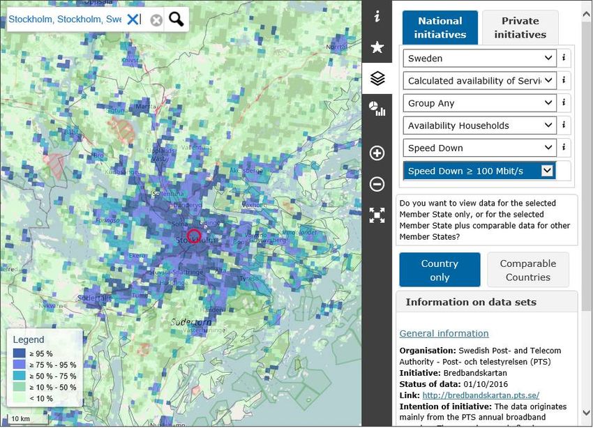
12National Initiatives – Sweden (QoS-1) Data: PTS, January 2018, 1km grid
13QoS-1 Speed Down ≥ 100 Mibt/s Data: PTS, January 2018, 1km grid
14List of the 32 initiatives that provided data so far
Resolution of data in Resolution of data in
Organisation Initiative
BBM provided their own tool
Austrian Ministry Breitbandatlas Österreich NUTS 3, 1km grid 100m grid
Cartes de couverture de l’accès fixe à la large
Belgian NRA NUTS 3 n/a
bande
QoS-1 (calculated availability of service - coverage)
Bulgarian Ministry Availability of Broadband Internet in Bulgaria NUTS 3 n/a
Croatian NRA Interactive GIS Portal NUTS 3 Addresses
Danish NRA Tjekditnet NUTS 3, 1km grid Addresses
Dutch NRA Breedband Atlas NUTS 3 n/a
Finnish NRA Nopean laajakaistan tarjonta Suomessa NUTS 3 n/a
French Ministry Mission France Très Haut Débit NUTS 3 Addresses
German Ministry Breitbandatlas des Bundes NUTS 3, 1km grid Addresses, 250m grid
Hungarian Ministry SZMR 1km grid Addresses
Icelandic NRA Ljosifjos 1km grid Addresses
Italian NRA Italian Broadband Map NUTS 3 Addresses
Luxembourgish NRA Geoportal NUTS 3 Municipalities
Polish NRA Polska Szerokopasmova 1km grid Addresses, Municipalities
Slovak NRA / VUS Coverage of NGA in Slovakia NUTS 3 Municipalities
Slovenian NRA AKOS Broadband map NUTS 3 Addresses
Spanish Ministry Informes de Cobertura NUTS 3 n/a
Swedish NRA Bredbandskartan 1km grid Addresses
postal code, LAU (open
UK NRA Connected nations report NUTS 3
data)
European Commission / 15
Broadband coverage in Europe NUTS 3 NUTS 3
IHSResolution of data in Resolution of data in their
Organisation Initiative
BBM provided own tool
Italian NRA MisuraInternet Mobile defined number of cities single measurements
Latvian NRA ITEST NUTS 3 single measurements
(measureed
provision)
French NRA Observatoire 1km grid single measurements
QoS-2
German NRA Breitbandmessung NUTS 3 single measurements
MONROE MONROE single measurements single measurements
RIPE Atlas RIPE Atlas single measurements single measurements
Greek NRA Hyperion single measurements single measurements
(measured experience)
Norwegian NRA Nettfart NUTS 3 single measurements
QoS-3
IP Label IP Label NUTS 3 single measurements
M-Lab M-Lab NUTS 3 single measurements
Netbravo Netbravo 1km grid single measurements
nPerf nPerf single measurements single measurements
16Thank You!
www.broadband-mapping.eu
User: BBM_dev
PW: 51105_4711Strategic objective for 2025 1. Gigabit connectivity for all main socio-economic drivers such as schools, transport hubs and main providers of public services as well as digitally intensive enterprises. 2. All urban areas and all major terrestrial transport paths to have uninterrupted 5G coverage. 3. All European households, rural or urban, will have access to Internet connectivity offering a downlink of at least 100 Mbps, upgradable to Gigabit speed.
Mapping:
    a policy, investment and transparency tool
The proposed Code requires regulators to map network investment
intentions, and enables public authorities to seek investors in under-served
areas:
• allows more joined-up policy, identifying private investment
   opportunities or public investment needs.
• allows regulators to increase transparency about network
   deployment plans and to provide investors with more predictability
   and protection.
• ensures that less densely populated communities benefit from better
   Internet connectivity.
• promotes a consistent approach to coverage obligations (in spectrum
   licences), to small-cell deployment and to network sharing, thereby
   stimulating 5G deployment and rural connectivity.
• ……….
• ……….
At EU level mapping also relevant
for:
• Developing Broadband plans: in 2016, the Commission called
on Member States to:
• review progress of their National Broadband Plans and update
them with a time horizon of 2025,
• in line with the strategic objectives set in this Communication
and the 5G Action Plan.
• Programming, implementing and monitoring the impact of
EU funds: ESIF (ERDF and EAFRD)
• The EC approval of NGN Plans constitute an ex-ante
conditionality to access ESI Funds (2014-2020)VHC Networks definition in the Code:
as at 8/5/2018
• 'very high capacity network' means either an electronic communications
network which consists wholly of optical fibre elements at least up to
the distribution point at the serving location or an electronic
communications network which is capable of delivering under usual
peak-time conditions similar network performance in terms of available
down- and uplink bandwidth, resilience, error-related parameters, and
latency and its variation.
• Network performance can be considered similar regardless of whether
the end-user experience varies due to the inherently different
characteristics of the medium by which the network ultimately
connects with the network termination point.New Code; Article 20: Information request to undertakings
as at 8/5/2018
"….national regulatory authorities, and, …other competent
authorities, shall have the power to require those undertakings to
submit information concerning:
• - future network or service developments that could have an impact
on the wholesale services that they make available to competitors, as
well as
• - on electronic communications networks and associated facilities
which is disaggregated at local level
• - sufficiently detailed to enable the geographical survey and designation
of areas in accordance with Article 22 ……….."
• ….
"Business confidentiality shall not prevent the timely sharing of
information between the competent authority, the Commission,
BEREC and any other competent authorities concerned for the purposes
of reviewing, monitoring and supervising the application of this
Directive. "
•Article 22: Geographical surveys of network deployments
(NOT AGREED YET)
• National regulatory authorities and/or other competent authorities shall conduct a
geographical survey ……and shall update it at least every three years.
• This geographical survey shall include
• a) a survey of the current geographic reach of such broadband networks within their
territory, as required in particular for conducting the tasks under this Directive
required by Articles :
• - 62 (Procedure for the identification of markets)
• - 65 (Market analysis procedure)
• - 81(Availability of universal service) ,
• - 66 (Imposition, amendment or withdrawal of obligations)
• and for the surveys required for the application of State aid rules.;
• This geographical survey may also include a forecast of up to three years
forecast of the reach of broadband networks, and more particular of very high
capacity networks …..
• …..This forecast shall include information on planned deployments by any
undertaking or public authority, in particular to include of very high capacity
networks and significant upgrades or extensions of legacy broadband
networks to at least 100 Mbps download speeds.
•Article 22: Geographical surveys of network deployments
(NOT AGREED YET/Text may change)
• The reliability of such forecasts shall be decided by the national
regulatory authority.
• The information collected … shall be at an appropriate level of local detail
and shall include sufficient information on the quality of service and
parameters thereof.
• The relevant authorities may designate an area with clear territorial
boundaries where, on the basis of the information gathered and any
forecast prepared …where….no undertaking or public authority has
deployed or is planning to deploy a very high capacity network or has
to significantly upgrade or extend its network to a performance of at
least 100 Mbps download speeds, or is planning to do so.
• National regulatory and/or other competent authorities shall publish
the designated areas.Article 22: Geographical surveys of network deployments
(NOT AGREED YET/Text may change)
Relevant authorities running the survey will make data available to authorities with
responsibility for:
• the allocation of public funds for the deployment of electronic communications
networks,
• the design of national broadband plans,
• defining coverage obligations attached to rights of use for radio spectrum and for
• verifying availability of services falling within the universal service obligation
• ensuring the same level of confidentiality and protection of business secrets as the
originating authority and inform the parties which provided the information.
Results shall also be made available to BEREC and the Commission upon their request
and under the same conditions.
• Data not subject to confidentiality shall be made directly accessible online to
allow reuse (in line with Directives 2013/37/EU).
• The responsible authority will also make available a tool enabling end-users
to determine the availability of connectivity in different areas, (with a level of detail
which is useful to support their choice in terms of connectivity services of operator
or service provider.Article 29 : Penalties and compensation
(NOT AGREED YET/Text may change)
Member States shall lay down rules on penalties, including fines and
predetermined or periodic penalties, or compensation, to prevent
infringements of
• national provisions …..or
• Legally binding decision issued by the Commission, national regulatory
or other competent authority pursuant to this Directive, and shall take
all measures necessary to ensure that they are implemented.
The penalties regarding incorrect or misleading information:
• must be appropriate, effective, proportionate and dissuasive and
• may only be imposed if such information was provided knowingly or
negligently and the operator:
a) has subsequently deployed a very high capacity network …or… has significantly
upgraded or extended its network to a performance of at least 100 Mbps download
speeds, in contradiction with its previously stated intentions, and cannot provide an
objective justification;
(b) has not deployed a network according to plans submitted, without an objective
justification.
•EU plaftorm
mapping of fixed and mobile
Broadband Services in Europe
(SMART 2014/0016)Why mapping at EU level?
• Current Commission capacity to map in Europe is a combination of
various sources.
• Annual report on Broadband Coverage in Europe in measuring
progress with respect to the broadband coverage targets set out in the
Digital Agenda (ad-hoc studies).
• At national and regional levels, mapping is increasingly based on
dedicated IT systems - often offering online platforms open to the
public. Key part for the development of the NGN plans (ex-ante
conditionality in the framework of ESIF) and individual broadband
rollout projects.
Drawbacks:
• Data is meaningful and reliable only at national/EU level, and for overall
policy purposes;
• Data does not support programming or comparison at regional/local level
• Data not useful for state aid purposes (not prospective investments)
• Data not sufficient to measures VHC performance (only download speeds)
• … 28Mapping broadband services:
towards an EU integrated platform
The Broadband mapping project (SMART 2014/0016) aims to :
aggregate measurements of connectivity of quality of service (QoS) and
quality of experience (QoE) connectivity. (TUV Rheinland Consulting will
develop this IT project until 2018).
facilitate information exchange and benchmarking between Member States.
The portal will be complementary to the mapping activities of EUMS and EEA
(Ministries, NRAs, regional agencies, users and consumers organisations etc.)
and will also gather private crowdsourcing QoS/QoE actions.
A Technical Review Panel made up of representatives from various data
providers and international experts assists the European Commission. Its
includes representatives from MS (IT, IE, FR), from NRAs (AGCOM,
ANCOM,UKE) and from BEREC Working Group on Network Neutrality (Ofcom,
BNetzA) BEREC Mobile Coverage WG (ARCEP). 29First EU-wide integrated broadband mapping platform
32 initiatives provided data:
• 20x QoS-1, (technical ability of existing
infrastructure - coverage)
• 6x QoS-2, (Line qualification)
• 6x QoS-3 (Actual user’s experience )
Data Providers and Beneficiaries:
• NRAs
• National Ministries or Agencies
• International Platforms and projects
• Consumers organisations
• Users at large
Aggregating existing data - from fixed and mobile
• public visualisation at NUTS-3 level;
• expert data portal at the highest level of
granularity available (for data providers);
• MoU with data providers to establish rule of
use/access and in lin with privacy rules
30Explorer view
QoS-1 Speed Down ≥ 30 Mibt/s
• QoS-1 provided: AT, BE, BG, DE,
DK, ES, FI, FR, HR, HU, IS, IT,
LU, NL, PL, SI, SK, SE, UK
• not displayed in this view, BG,
ES, HR, HU, NL, PL, SK, UK, since
they are grouped according to a
different methodology
• data shown was collected
between 2016 and 2017
• further updates of 2017 data are
expected
31QoS-1 Speed Down ≥ 30 Mbit/s Data: AGCOM, 30th Oct 2017, NUTS3
Explorer view
32QoS-1 Speed Down ≥ 30 Mbit/s
Explorer view
Data: AGCOM, 30th Oct 2017, NUTS3 33QoS-1 Speed Down ≥ 30 Mbit/s, medium population density
Analysis view Selection of NUTS3 areas by
different level of population
density:
• low: 0 - 100 inhabitants /
km²
• medium: 101 – 500
inhabitants / km²
• high: > 501 inhabitants /
km²
34
Data: AGCOM, 30th Oct 2017, NUTS3QoS-1 Speed Down ≥ 30 Mbit/s, lower than average GDP
Analysis view
Selection of NUTS 3 areas
based on GDP per
capita:
• 95%-105% of average
GDP
• > 105% of average
GDP
• < 95% of average GDP
• filter set onQoS-1 Speed Down ≥ 30 Mbit/s, lower than average GDP
Selection of NUTS3 areas
based on urbanization level
Analysis view • predominantly urban areas
(at least 50% of population
lives in clusters with
>1500 inhabitants/km²)
• intermediate areas (1500
inhabitants/km²;3 categories serving different purposes and objectives
Wha Theoretical network performance of existing infrastructure
t (coverage, no pure infrastructure data)
QoS-1:
Calculated Wired: Assessment /
availability calculation / marketed speeds Wireless: Radio field planning
Ho
of service by provider / geodata-based
w
simulation models / prediction
tools
Wha Provision of service measured at the Customer Premises Equipment
QoS-2: t (CPE), e.g. routers, mobile devices 9EG (Samknows in UK)
Measured
Wired Wireless
provision
Ho Measurement through panel Measurement through drive tests
of service
w probes with filter to exclude end or speed tests to exclude end
user´s environment user´s environment
Wha
Actual user’s experience when using Internet Access Service (IAS)
QoS-3: t
Measured
Wired Wireless
experience
Ho Measurement via online speed Measurement via online speed
of service 37
w tests including end user’s tests including end user’s
environment environmentDifferences between QoS groups
Data sources,
QoS-1: German Ministry
QoS-2: German NRA
QoS-3: M-Lab
Legends:
• QoS-1 focuses on
percentage availability
of one speed category
• QoS-2 & 3 focus on
measured
throughput values,
e.g. average, median
38National Initiatives – Sweden (QoS-1) Data: PTS, January 2018, 1km grid
39QoS-1 Speed Down ≥ 100 Mibt/s Data: PTS, January 2018, 1km grid
40List of the 32 initiatives that provided data so far
Resolution of data in Resolution of data in
Organisation Initiative
BBM provided their own tool
Austrian Ministry Breitbandatlas Österreich NUTS 3, 1km grid 100m grid
Cartes de couverture de l’accès fixe à la large
Belgian NRA NUTS 3 n/a
bande
QoS-1 (calculated availability of service - coverage)
Bulgarian Ministry Availability of Broadband Internet in Bulgaria NUTS 3 n/a
Croatian NRA Interactive GIS Portal NUTS 3 Addresses
Danish NRA Tjekditnet NUTS 3, 1km grid Addresses
Dutch NRA Breedband Atlas NUTS 3 n/a
Finnish NRA Nopean laajakaistan tarjonta Suomessa NUTS 3 n/a
French Ministry Mission France Très Haut Débit NUTS 3 Addresses
German Ministry Breitbandatlas des Bundes NUTS 3, 1km grid Addresses, 250m grid
Hungarian Ministry SZMR 1km grid Addresses
Icelandic NRA Ljosifjos 1km grid Addresses
Italian NRA Italian Broadband Map NUTS 3 Addresses
Luxembourgish NRA Geoportal NUTS 3 Municipalities
Polish NRA Polska Szerokopasmova 1km grid Addresses, Municipalities
Slovak NRA / VUS Coverage of NGA in Slovakia NUTS 3 Municipalities
Slovenian NRA AKOS Broadband map NUTS 3 Addresses
Spanish Ministry Informes de Cobertura NUTS 3 n/a
Swedish NRA Bredbandskartan 1km grid Addresses
postal code, LAU (open
UK NRA Connected nations report NUTS 3
data)
European Commission / 41
Broadband coverage in Europe NUTS 3 NUTS 3
IHSResolution of data in Resolution of data in their
Organisation Initiative
BBM provided own tool
Italian NRA MisuraInternet Mobile defined number of cities single measurements
Latvian NRA ITEST NUTS 3 single measurements
(measureed
provision)
French NRA Observatoire 1km grid single measurements
QoS-2
German NRA Breitbandmessung NUTS 3 single measurements
MONROE MONROE single measurements single measurements
RIPE Atlas RIPE Atlas single measurements single measurements
Greek NRA Hyperion single measurements single measurements
(measured experience)
Norwegian NRA Nettfart NUTS 3 single measurements
QoS-3
IP Label IP Label NUTS 3 single measurements
M-Lab M-Lab NUTS 3 single measurements
Netbravo Netbravo 1km grid single measurements
nPerf nPerf single measurements single measurements
42You can also read