FISHPOND AQUACULTURE INVENTORY IN MAROS REGENCY OF SOUTH SULAWESI PROVINCE
←
→
Page content transcription
If your browser does not render page correctly, please read the page content below
International Journal of Remote Sensing and Earth Sciences Vol.10 No.1 June 2013:25-35

    FISHPOND AQUACULTURE INVENTORY IN MAROS REGENCY OF SOUTH
                       SULAWESI PROVINCE

    Yennie Marini1* , Emiyati1, Teguh Prayogo1, Rossi hamzah1, and Bidawi Hasyim1
         1
           Indonesian National Institute of Aeronautics and Space (LAPAN), Jakarta
                            *
                             E-mail: yennie.marini@lapan.go.id

Abstract. Currently, fishpond aquaculture becomes an interesting business for investors because of its
profit, and a source of livelihood for coastal communities. Inventory and monitoring of fishpond
aquaculture provide important baseline data to determine the policy of expansion and revitalization of
the fishpond. The aim of this research was to conduct an inventory and monitoring of fishpond area in
Maros regency of South Sulawesi province using Satellite Pour l’Observation de la Terre (SPOT-4)
and Advanced Land Observing Satellite (ALOS) Phased Array type L-band Synthetic Apeture Radar
(PALSAR). SPOT image classification process was performed using maximum likelihood supervised
classification method and the density slice method for ALOS PALSAR. Fishpond area from SPOT
data was 9693.58 hectares (ha), this results have been through the process of validation and
verification by the ground truth data. The fishponds area from PALSAR was 7080.5 Ha, less than the
result from SPOT data. This was due to the classification result of PALSAR data showing some
objects around fishponds (dike, mangrove, and scrub) separately and were not combined in fishponds
area calculation. Meanwhile, the result of SPOT-4 image classification combined object around
fishponds area.

Keywords: Fishpond aquaculture, Optic remote sensing, Satellite imaging radar, SPOT-4, PALSAR

1    INTRODUCTION                                         Remote sensing in various aspects of
     The coastal area of South Sulawesi              aquacultures was demonstrated by Loubersac
Province has large potential for development         (1985) who used simulated high-resolution
of fishponds aquaculture. For example, in            SPOT data (10-20 m) for aquaculture site
2008 Maros Regency reached 20,197.93 tons            selection. Kapolsky et al. (1987) has also
of fish production in which 68.3% of capture         made some GIS approach for aquaculture site
fisheries, 26.4% of fishponds aquaculture,           selection. Travaglia et al. (2004) applied ERS
and the remaining 5.3% of other fisheries            SAR and RADARSAT data for maping
production. Therefore, fishponds aquaculture         coastal aquaculture and fisheries structure in
had a significant role in determining the            Lingayen Gulf, Philippines.
fisheries production in Maros (Central                    The aim of this research was to apply
Bureau of Statistics Maros Regency, 2009).           remote sensing technique to inventory the
     Inventory and monitoring of natural             fishponds aquaculture by using optical
resources have normally conducted on                 (SPOT-4) and radar data (ALOS PALSAR)
conventional system that require time, effort        in Maros Regency, South Sulawesi Province.
and significant costs. Remote sensing                The method used in optic data was
technology can be used for inventory and             supervised maximum likelihood while for
monitoring of natural resources more                 radar data using the density slice method. In
efficiently, the solution to the problems of the     an effort to get a more accurate classification
conventional observation. Remote sensing             results, it was necessary to verify using field
techniques offer an alternative, giving an           data obtained through field surveys. The use
almost instantaneous overview over large             of optical remote sensing satellite data for
areas at relatively low costs, and able to           fishpond aquaculture limited to cloud-free
obtained data periodically and real time in          conditions, which are often difficult to be
areas that are difficult to achieve by               found in some parts of Indonesia. The use of
conventional means.                                  radar remote sensing data can overcome the
                                                     problems in optical remote sensing.

               @Indonesian National Institute of Aeronautics and Space (LAPAN) and
                International Society of Remote Sensing and Earth Sciences (IReSES)                    25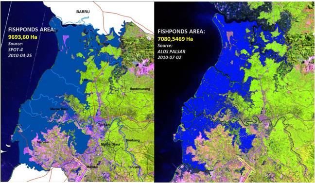
Yenni Marini et al.

2   MATERIALS AND METHOD                                 The research also used a radar satellite
    Inventory and monitoring of fishpond             imagery ALOS PALSAR Level 1.5 Dual
area in Maros regency of South Sulawesi              Polarization (Fine Beam Dual Polarization/
province used SPOT-4 and ALOS PALSAR.                FBD namely HH and HV) acquired on 2 July
The study area was located in coastal areas of       2010. ALOS PALSAR image had a spatial
Maros regency, South Sulawesi province               resolution of 12.5 x 12.5 m2 with a projection
with boundary coordinate 4º 42 '56 "- 5 º 13'        of UTM WGS 84 Zone 50 South (Figure 1).
57" South Latitude; 119 º 27 '47 "- 119 º 58'        Supporting data that used in this research
29" East Longitude (Figure 1). In this               were digital topographic elevation data
research, we used two SPOT-4 images                  (Digital Elevation Model/DEM) from SRTM;
acquired on 25 April 2010 and 15 June                the administrative boundary map of
2011(Figure 2).                                      Indonesia and Terrain map Indonesia (scale
                                                     1:50.000).

            Figure 1. Research Location in Maros Regency, South Sulawesi Province

          20100425SP4310360S0G2AXI                        20110615SP4310360S0G2AXI
                     (a)                                             (b)

             Figure 2. SPOT-4 image satellite 25 April 2010 (a) and 15 June 2011 (b)

26                        International Journal of Remote Sensing and Earth Sciences Vol.10 No.1 June 2013
Fishpond Aquaculture Inventory In Maros…

      The methods in this research used optical        tion method.
(SPOT-4) and radar (ALOS PALSAR) remote                     SAR image processing consisted of a
sensing technique. SPOT image classification           geometric correction (orthorectification),
process was performed using maximum                    radiometric calibration (absolute), noise
likelihood supervised classification method and
                                                       reduction image disturbance due to the
the density slice method for ALOS PALSAR. In
general, method performed in this research are
                                                       influence of atmosphere (speckle Noise
presented in the flowchart on Figure 3.                Reduction), identification of fishponds using
     Technical classification of remote                adaptive filter (Frost, Gamma and Lee) with
sensing imagery generally divided into two             the smallest window size which was 3 x 3,
types; visual classification and digital               object identification using density slicing
classification. Visual classification was done         method and the classification of fishponds.
by interpretation on delineation images                     Data PALSAR level 1.5 already
directly, while the digital classification             contained geometric information based on
methods was done by supervised/                        GRS80 ellipsoid.        However, the same
unsupervised (based on the digital image)              georeferenced was not used with SPOT-4 in
using specific software. One of the digital            this research. Therefore geometric correction
classification method used in this study was           was performed using the image reference of
supervised maximum likelihood classifica-              SPOT-4 15 June 2011 image orthorectified.

                Figure 3. The flowchart of SPOT-4 and PALSAR data processing

International Journal of Remote Sensing and Earth Sciences Vol.10 No.1 June 2013                      27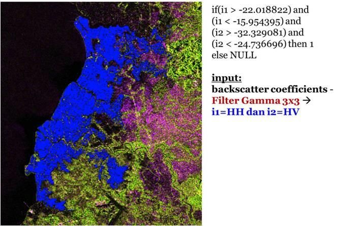
Yenni Marini et al.

3 RESULTS AND DISCUSSION                            interpreted as non fishponds area. However,
3.1 Optical data classification result              after ground check, it turned out that the
     The classification result of fishponds         location was fishponds area mixed with
area from SPOT-4 data in Maros regency              other vegetation (red circles in Figure 4a
was 9,462.527 hectares (Figure 4). This area        and 4b).
calculation was taken before the field survey.           The     difference    in    observation/
Field survey is an effort to get a more             interpretation is shown in Figure 6, the area
accurate classification result. Deriving the        indicated by the color of cyan, while the area
correct information from the analysis of            in accordance with the ground truth is
remotely sensed data requires some ground
                                                    colored by purple. These changes are mostly
verification data. Once revised and verified
                                                    found in Bontoa, Maros Baru, Marusu and a
by the ground truth data, the fishponds area
became 9,693.58 hectares (Figure 5) or              small percentage located in Lau district.
2.44% larger. This was due to the different         Classification results were also verified by
interpretation of the data processing with the      geotagging of the observation points with
actual situation, for examples fishponds area       IKONOS data on Google earth and Google
in Bontoa, before ground check the area are         Map website (Figure 7).

      Figure 4. Classification result of fishponds area before verified by ground truth data

28                       International Journal of Remote Sensing and Earth Sciences Vol.10 No.1 June 2013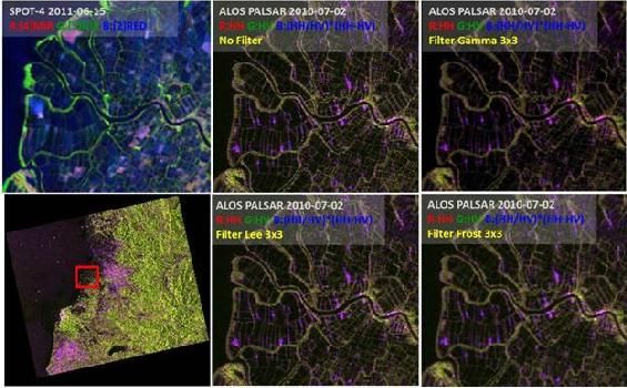
Fishpond Aquaculture Inventory In Maros…

         Figure 5. Classification result of fishponds area verified by ground truth data

Figure 6. Fishpond area changes in Maros Regency before and after verified by ground truth
          data.

International Journal of Remote Sensing and Earth Sciences Vol.10 No.1 June 2013                      29
Yenni Marini et al.
Figure 7. Geotagging of the observation points with IKONOS data on Google Earth Website
and Google Map.
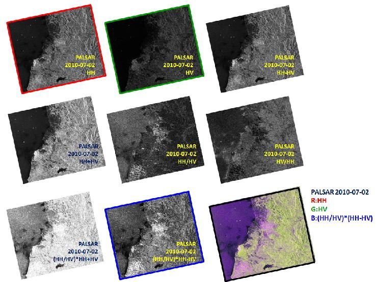
3.2 Radar data classification result reflection generally occurred on vegetation
Visual object identification was done by object. This resulted in bright hue to the
creating a color composite of the two image of vegetation (Isti and Nur, 2012)
polarization PALSAR data and artificial band Six other artificial bands were made to
from two existing polarization. From both show the appearance of the object based on
polarization, we produced 6 ALOS PALSAR addition and subtraction of two major bands
image i.e., HH-HV, HH + HV, HH/ HV, HV / (HH and HV) i.e., the ratio of the main band
HH, (HH / HV) * (HH + HV) and (HH/HV) and the multiplication of the ratio of the
* (HH-HV). Based on these two polarization addition and subtraction band. Based on the
PALSAR data, the DN (digital value) pixels creation of six bands, visually there was no a
at HH polarization image had a higher value specific object appearance, except for 1 band
than the HV. This was because the energy of by multiplying the ratio of the addition and
the signal transmitted and received back by subtraction of the band (HH/HV) * (HH-
the sensor had the same relative scale in HH HV). This artificial band showed single
polarization. While at HV polarization, scattering from a flat surface with sparse
emitted and received energy had decreased in vegetation and a variety of low density (for
the atmosphere. example rice vegetative phase. Therefore, to
From the two polarizations acquired in facilitate the visual identification of objects,
different objects appearance, HH polarization we made a combination band or RGB color
image had the advantages of object composite image of band polarizations HH,
identification with reflection angle type. HV, (HH / HV) * (HH-HV). Visually from
Object with respond of reflection angle had a the appearance of the composite image, the
high backscattering value (Wang, 2007). objects with a flat surface (the surface water
Urban areas with a high level of building of the pond, dried pond), rough (forest and
development affect on a high value of urban areas) as well as of the two
backscattering. High backscattering was appearances (the ground or water with sparse
visualized with a bright hue in images ALOS vegetation) can be clearly distinguished.
PALSAR HH polarization. HV polarization Composite image as well as a composer of
had a high backscattering value on the combination band color and appearance
volumetric reflection type. Volumetric of the object can be seen in Figure 8.
30 International Journal of Remote Sensing and Earth Sciences Vol.10 No.1 June 2013
Fishpond Aquaculture Inventory In Maros…

     Composite color image of ALOS                     Hasanuddin Airport. At this site in June
PALSAR can be used to complement the                   2011, land cover changed into green (rice
visual identification as well as the results in        generative phase). Appearance of fishponds
digital SAR image processing in identifying            area was more obvious from SAR imagery
the fishponds. In fishpond identification, time        compared with optical images (at least two
series data were used to see the difference            images necessary to distinguish rice fields
between the fishponds and in particular rice           and ponds).
paddy field (in the water and dried phase)                  Identification of fishponds from ALOS
because the pattern and shape provided                 PALSAR image was done by applying an
similar appearance. Some images can be                 adaptive filter Frost, Gamma, and Lee. Based
distinguished the appearance of fishponds              on the results obtained by applying the three
and paddy fields by the spectral response and          filters, filter Gamma 3 x 3 showed the
the value of backscattering radar imagery.             appearance of the pond clearer than the
The difference between fishponds, paddy                results of Frost and Lee filters, in particular
fields and appearance of other objects can be          to distinguish the ponds dyke and water
clearly seen in Figure 9.                              bodies (Figure 10). Other land surface in the
     The image of SPOT-4 of 25 April 2010              form of soil and vegetation around the pond
and the image of ALOS PALSAR showed                    can also be separated clearly. Frost filter
that the pattern and appearance were almost            exhibited less clear of ponds dyke, while Lee
the same because it was in relatively short            filter produced pixels roughness casuing
period of time compared with SPOT-4 image              blurring appearance of ponds. The results
of 5 June 2011. In April 2010, paddy fields in         showed that Gamma filter was the best to
water phase were visible in the east of                identify and separate object from other object
fishponds area in Maros regency. This                  ponds. Separation was done by searching the
condition was also observed from ALOS                  pond backscattering value range of PALSAR
PALSAR image, particularly in the northeast            image using density slicing.

Figure 8. Dual polarization images (HH dan HV) and 6 artificial images of ALOS PALSAR
          data and composite image (R=HH, G=HV, B=(HH/HV)*(HH-HV))

International Journal of Remote Sensing and Earth Sciences Vol.10 No.1 June 2013                      31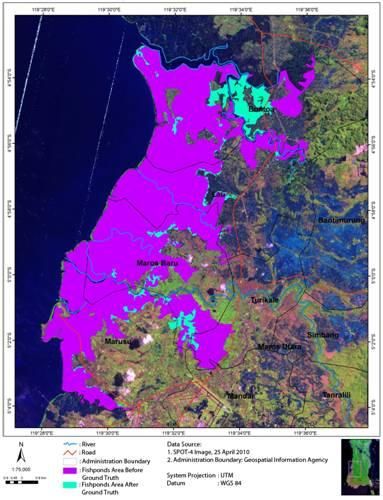
Yenni Marini et al.

Figure 9. Land Cover and Fishponds Appeareances on SPOT-4 and ALOS PALSAR Images
          with Different Aqcusition Date

Figure 10. Fishponds visibility from optic sensor data (SPOT-4) and Frost, Gamma, and Lee
           filter result with 3x3window size on ALOS PALSAR image.

     Density slicing is the process of              an earthen wall whose thickness ranges
converting the grey levels of an image into a       approximately from half meter to several
series of discrete classes, each of which is        meters, and elevation from the water surface
equivalent to a data-range value. It provides a     is at the most one meter. Relatively smooth
means of visually assigning classes to              surfaces such as calm water appear in the
differences in radar backscatter or                 radar image as dark tones. The approach
backscatter texture according to image              assumes that water bodies appear in SAR
brightness. Generally, a density slice is           imagery as areas of low backscatter, but low
applied to a single variable by selecting data      returns may also include pixels of smooth
ranges and highlighting thematic classes or         non-water regions. Nevertheless, the density
areas of interest by color coding (Cambell,         slice technique was used in this study to
2002).                                              evaluate the performance of the products of
     In the case of mapping fishponds and           SAR sensor for fishponds identification.
non-fishponds, density slicing assumes a                 Data-range values when applying the
threshold for identification of fishponds,          density slice for the fishponds class to
since it is based on levels of brightness (or       PALSAR image was           -22.01 up to -15.95
radar    backscatter    differences)     where      for HH polarization and for HV polarization
fishponds are small enclaves of calm water          was -32.33 up to -24.72. Figures 11 shows
surrounded by dykes on all sides. A dyke is         the density slice ranges for fishponds class in

32                       International Journal of Remote Sensing and Earth Sciences Vol.10 No.1 June 2013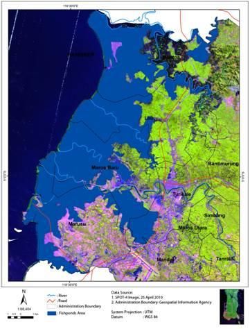
Fishpond Aquaculture Inventory In Maros…

the PALSAR image in HH and HV                          SPOT-4 2010 image that has been verified
polarization along graphic profile of the              with the ground truth data. The difference
value of objects extracted and the                     was due to different classification results.
classification of fishponds area from                  The classification results of PALSAR data
PALSAR data shown in Figure 12.                        showed some objects around fishponds (dike,
     The result from density slice technique           mangrove and scrub) separately and were not
on PALSAR data 2010 showed that the                    combined in fishponds area. Meanwhile the
spatial size estimation of the fishponds               results of SPOT-4 image classification
illustrated in Figure 13 was around 7080.5 ha          combined object around fishponds area.
compared with 9693, 6 Ha estimated from

    Figure 11. Graphic value profile of the objects extracted by the density sliced method.

  Figure 12. Fishponds area (blue color) of PALSAR imagery using density slicing method.

International Journal of Remote Sensing and Earth Sciences Vol.10 No.1 June 2013                      33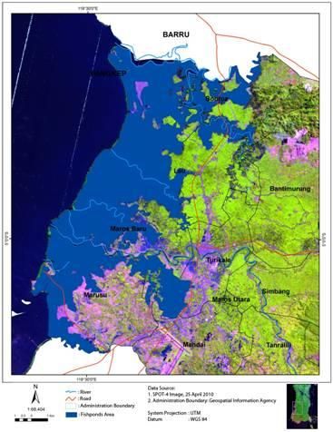
Yenni Marini et al.

Figure 13. Classification result of fishponds area in Maros regency using SPOT-4 and ALOS
           PALSAR data.

   Fishponds identification using ALOS               REFERENCES
PALSAR imagery provided information that             Campbell, B.A, 2002, Radar remote sensing
unconstrained by cloud cover and backscatter                for planetary surfaces, Cambridge
from the fishponds components allowed for                   University Press.
their easy identification and separation from        Isti F.K., dan M.F. Nur, 2012, Comparison of
other natural features.                                     land cover classification accuracy from
                                                            the result of image fusion of ALOS-
4 CONCLUSION                                                AVNIR-2 and ALOS PALSAR on
   The determination of fishpond area in                    different polarization with Wavelet
Maros regency using SPOT-4 and PALSAR                       transformation, Journal of Earth of
data showed different result. SPOT-4 data                   Indonesia, 1(2) [accessed on 30 May
exhibited the fishponds area in Maros                       2012] (in Indonesian).
regency of 9,693.58 ha, while PALSAR data            Loubersac, L., 1985, Study of inter tidal zone
showed of 7,080.5 ha. The SPOT-4                            using     simulated      SPOT      data:
estimation was validated with grouns truth                  inventorying of aquaculture sites in
data.                                                       inter tropical zone: report on
   The PALSAR estimation was less about                     application of remote sensing to
27% than SPOT-4 estimation due the                          aquaculture and inland fisheries. FAO
classification results of PALSAR data                       Remote Sensing Center Service,
indicated some objects around fishponds                     27:261-272.
(dike, mangrove and scrub) separately and            Kapetsky, J.M., L. McGroger and E.H.
not combined in fishponds area, meanwhile                   Nanne,      1987,     A    geographical
the results of SPOT-4 image classification                  information system and satellite remote
combines object around fishponds area.                      sensing to plan for aquaculture
     The PALSAR data are unique not only                    development: a FAO-UNEP/GRID
for their inherent all-weather capabilities in              cooperative study in Coasta Rica. FAO
which very important for aquaculture                        Fisheries Technical Paper, 287, FAO,
activities in tropical areas, but also essential            Rome.
because the backscatter from the structure
components allows for their identification
and separation from other features.

34                        International Journal of Remote Sensing and Earth Sciences Vol.10 No.1 June 2013
Fishpond Aquaculture Inventory In Maros…
Travaglia, C., G. Profeti, J. Aguilar- distribution of the 1997 Mw 7.5 Manyi,
Manjarrez, and N.A. Lopez, 2004, Tibet, earthquake from InSAR
Mapping coastal aquaculture and measurements, Journal of
fisheries structures by satellite imaging Geodynamics, 44(3-5):200-212.
radar: case study of the Lingayen Gulf,
the Philippines, FAO Fisheries
Technical Paper, 459, Rome.
Wang, H., C. Xu, and L. Ge, 2007,
Coseismic deformation and slip
International Journal of Remote Sensing and Earth Sciences Vol.10 No.1 June 2013 35You can also read