EXTENDED FLOATING-CAR DATA FOR THE ACQUISITION OF TRAFFIC INFORMATION
←
→
Page content transcription
If your browser does not render page correctly, please read the page content below
EXTENDED FLOATING-CAR DATA
       FOR THE ACQUISITION OF TRAFFIC INFORMATION

                                  Werner Huber
            Research Engineer, BMW AG, EW-1, 80788 Munich, Germany
                Phone: ++49 89 382-44989, Fax ++49 89 382-44988
                         e-mail: werner.hb.huber@bmw.de

                                  Michael Lädke
      Research Engineer, Robert Bosch GmbH, FV/SLH-Ld, P.O. Box 77 77 77
                           31132 Hildesheim, Germany
               Phone: ++49 5121 49-5355, Fax ++49 5121 49-2538
                        e-mail: michael.laedke@fr.bosch.de

                                  Rainer Ogger
       Team Leader Development, DDG Gesellschaft fuer Verkehrsdaten mbH,
            Niederkasseler Lohweg 20, D-40547 Duesseldorf, Germany
                            Phone +49 211 52777 410
                             Fax +49 211 52777 409
                           e-mail: rainer.ogger@ddg.de

                                       SUMMARY

If traffic information is to be up-to-date, a comprehensive and reliable data acquisition
system is needed. However, financial constraints mean that this requirement cannot be
satisfied for much of the road network. For this reason, road traffic engineers are
making increasing use of intelligent vehicles as mobile sensors, so-called “floating
cars”, to determine the traffic situation. In modern vehicles, the data available include
not just vehicle speed but also a wide variety of other variables. These can be acquired
in digital form from the vehicle’s data buses. With their help it is possible to develop
better traffic information and new telematics services which contribute to increasing
road safety and driver convenience. Together with partners from industry, BMW is
working within the German MoTiV research program on the realisation of a field test in
which this concept can be tried out. This paper provides an overview of the concept
involved and of initial results.

                                           1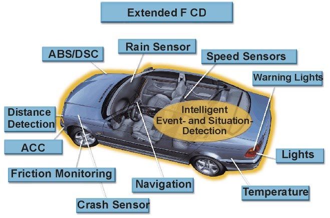
INTRODUCTION

Experts estimate the annual cost of traffic jams, disruption and accidents at several
billion marks in Germany alone. Given this situation, and the fact that there are
ecological and economic limits to the expansion of the road network, intelligent
transport systems and, in particular, traffic control and information systems are
becoming increasingly important.

Up-to-date high-quality traffic information requires a reliable and comprehensive
means of acquiring data. This requirement cannot be fulfilled in respect of large
sections of the traffic network. While comprehensive traffic data detection is generally
incorporated at the traffic planning stage in the case of collective traffic management
systems on motorways, there is very little provision for obtaining traffic data that would
enable up-to-date traffic information to be supplied over a wide area. Interruptions to
the traffic flow are thus either detected far too late by the police or reported
coincidentally by persons equipped with a mobile telephone. This limited and
incomplete acquisition of data causes the quality of the traffic information services to
suffer: car drivers complain that traffic messages are not broadcast at all or are heard
too late on the radio, or may be tempted to try a promising diversion in the event of a
traffic hold-up, only to find themselves in another traffic jam elsewhere.

The operators of traffic information services are therefore making increasing efforts to
supplement the acquisition of traffic information with traffic data acquired by mobile
means and thereby close any qualitative or quantitative gaps in the data base.

                THE PRINCIPLE OF FLOATING-CAR DATA ACQUISITION

In Germany, there have been attempts to use vehicles that “float” with the traffic for
data acquisition since the mid-eighties. These attempts were associated with individual
route guidance systems that were intended to allow dynamic guidance to a destination
via the road network by using vehicles participating in the system for traffic data
acquisition. Examples of these systems are Ali- and Euroscout (Siemens) and
SOCRATES (Philips). In these systems floating cars (FC) were used as mobile sensors
to record speed-related parameters and to report this data (FCD) together with the
vehicle’s position to a control centre.

This basic principle was taken up again in 1997 by the two largest private telematic
service providers in Germany, Mannesmann-Autocom and Tegaron, who carried out a
field trial called VERDI using new technologies, like cellular mobile phone networks
and GPS, and algorithms for vehicle data processing. The outcome was the CEN
Standardisation Proposal of GATS (Global Automotive Telematics Standard).

                                            2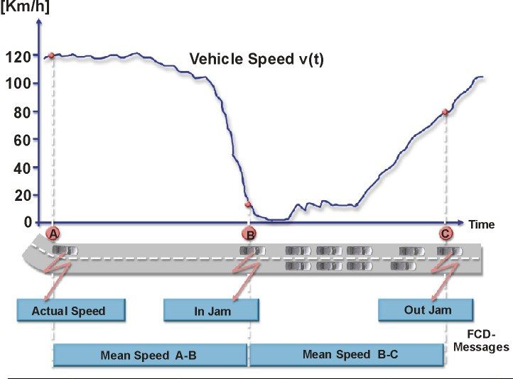
In all the field trials, FCD based on specific sections of road was found to be of positive
benefit for obtaining traffic information. However, to enable useful information to be
obtained from FCD alone a certain proportion of the vehicle population has to be fitted
with the system, this proportion varying from 1 to 5 % depending on what level of
quality of traffic information is required. Until such rates are achieved, FCD can
provide a means of acquiring rudimentary information about traffic disruption on a
road network without sensors (e. g. rural roads) and a means of supplementing
conventional systems for traffic data acquisition (e.g. those using induction loops) on
specific sections of road.

Figure 1 shows the functional principle of floating car data (FCD) acquisition: speed
values recorded second by second in the vehicle’s transceiver device are analysed and
stastistically condensed with the aid of algorithms. This yields either route-section or
route-point related characteristic values or traffic flow events.

                           Fig. 1: Principle of FCD acquisition

Characteristic route-section related data are for example the journey time or the mean
journey speed between two route points. GATS FCD reference implementation

                                            3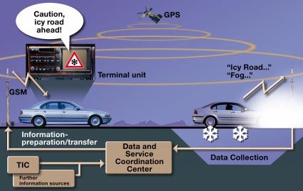
determines mean travel speeds for characteristic route sections. In addition to the mean
travel speed value, its variation is also computed, since this provides information on the
degree of traffic flow disturbance. Characteristic route sections are determined by an
algorithm in the vehicle’s transceiver device in accordance with “mean travel speed
since start of journey” and “current travel speed”.

At the same time, algorithms to detect congestion are run, and transmit a message to the
control centre if events such as “entering congested stretch” or “leaving congested
stretch” are identified. An event such as entering a congested stretch is defined if it has
been detected by two independent algorithms. Leaving the congested stretch is also
registered as an event in the vehicle’s transceiver device in order to enable periods of
time spent in traffic congestion and the length of the congested sections of road to be
determined. The mobile radio telephone (GSM/SMS) is used to transmit these data after
compression as information from the floating car to the control centre, either
periodically or when an event occurs.

The vehicle’s positions are compressed into what is known as a “string of pearls” by
means of a further algorithm in its transceiver device. Each FCD message transmitted
from the unit is accompanied by a position report that contains the vehicle’s last-known
positions. These position data are needed at the control centre for the map matching
process.

Since 1997 the Gesellschaft für Verkehrsdaten mbH (ddg) has operated a private-
enterprise control centre for the acquisition of traffic data in Germany, including FCD.
At this centre, data from all vehicles are collected, analysed and processed into traffic
information.

                           EXTENDED FLOATING CAR DATA

Beside the vehicle speed, there is a whole range of other operating and switching data
available in digital form on the bus systems of modern vehicles. They are obtained from
switches, sub-systems or sensors that are either standard or optional equipment on the
vehicle. Being available in digital form, they can be registered on the vehicle without
undue complexity and used for the process of obtaining traffic and environmental
information. These data are referred to as Extended Floating Car Data (XFCD). Data
from the following sources are of particular interest:
− the windscreen wipers or rain sensor,
− the external thermometer and the air-conditioning system,
− the vehicle’s light system (brake and fog lights),
− the hazard warning flashers etc.
− the sensors for the systems controlling the vehicle dynamics,
− driver assistance systems.

                                            4
By acquiring and evaluating these data it might be possible to obtain information on the
traffic and the general situation that goes far beyond what was available initially with
FCD. Figure 2 shows the vehicle data and systems used for XFCD data acquisition.
Fig. 2: Vehicle sensors and signals for XFCD acquisition
For any mobile data acquisition system, economically viable operation is a decisive
factor. For this reason, condensation of the volume of data, effective coding and control
of the transmitting activity are essential in order to limit the reported messages to
essentials. XFCD is intended, in a similar manner to FCD data, to be processed on the
vehicle into event, traffic situation and road condition messages and passed to a data
centre. Based on route-section related and local traffic and hazard situations, for
example
− approaching start of congested area
− heavy rain, aquaplaning or sheet ice
− poor visibility and fog
event identification algorithms are being developed that can infere from the avaiable
measured values and identify and report these “events”. For instance, from the
5condition of the windscreen wipers, use of the fog lights and the vehicle’s speed it is
possible to derive assessments of the current weather situation and road conditions. If a
traction control system is activated at a low outside temperature, this together with the
windscreen wiper frequency and the road speed of the vehicle could be taken as an
indication of a risk of slippery road surfaces locally.
These messages from the vehicles can then be processed in a data centre and
transmitted to other road users as traffic information or warning messages. Such ideas
are currently being followed up in a German research project called MoTiV (1996-
2000) involving German motor-vehicle manufacturers and suppliers and will be put to
the test in a field trial.
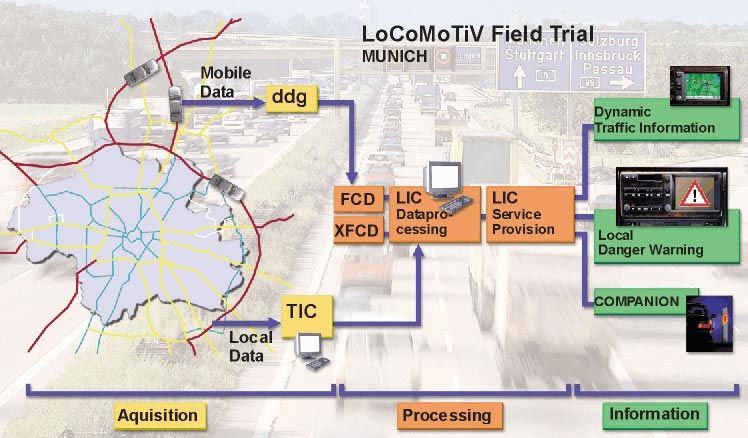
THE LOCOMOTIV FIELD TRIAL
Conceptual Design
An XFCD system of this kind is currently being designed as part of the MoTiV project.
The Short Message Service (SMS) available on the cellular mobile phone network
(GSM) has already been successfully tested in the FCD trials and would be an
economical means of data transmission. GPS is used to locate the vehicle.
Commercially viable telematic devices that meet the GATS specification are being used
as terminals. In the LoCoMoTiV field test, BMW is trying out the entire telematic
information chain from mobile traffic data detection to the extraction of information at
the control centre and the provision of traffic information in the vehicle. The field test
is to be held in three phases (Figure 3):
In Phase 1, 100 test participants in the Munich area of Germany were selected and their
vehicles equipped with a commercial FCD transceiver. FCD generation is automatic
and transmission takes place to a data centre developed and set up specially for the field
trial, the LoCoMoTiV-Information-Center (LIC) in Munich. In addition, the local
traffic data obtained conventionally from the Traffic Information Center Bayern (TIC
Bavaria) are also supplied to the LIC. This makes it possible to assess the value of the
mobile traffic data compared with local measurements and to generate an integrated
form of information on the traffic situation.
In Phase 2a of the field trial, the emphasis is on equipping experimental vehicles to
obtain XFCD data. With the aid of the infrastructure created in Phase 1, compressed
traffic, hazard and road-condition information obtained from XFCD sources is
transmitted to the LIC and subjected to further processing there. The recognition
models to be tested are implemented on a vehicle PC, which has two interfaces, one for
the telematics terminal and one for the car data bus to obtain the vehicle data. When a
6particular situation is detected, the terminal encodes and transmits the message to the
LIC.
The chain of information is closed in Phase 2b, in which once again test vehicles will
be equipped with PC-based telematic platforms specically developed for this purpose.
These vehicle devices receive local hazard warning messages and supply them to the
driver.
Results how FCD/XFCD could best be used as part of a traffic information
management system and what proportion of vehicles would have to be equipped to
provide the various information systems with a more adequate supply of data will be
available with the end of MoTiV in the year 2000. Moreover, the acquisition of XFCD
is a pre-requisite for the construction of new traffic information services that can focus
on local dangers, which would warn the driver of unforeseeable dangers during a
journey.
Fig. 3: Architecture of the LoCoMoTiV Field Trial
Telematic Service: Local Danger Warning
By the time LoCoMoTiV has ended, a demonstration service known as Local Danger
Warning will have been developed, and will supply the driver with a visual and audible
warning of danger-areas on the road. In order to enhance the warning effect as sensed
by the driver, the warnings will only be supplied if the vehicle is moving towards the
7danger area. In the vehicle’s transceiver device the traffic messages are subjected
automatically to a relevance check with the aid of GPS and the navigation system, to
confirm that the vehicle is in fact situated on the affected section of road. The traffic
information is generated in the LIC data and service centre. For the XFCD, data from
other sources such as Traffic Information Centres (e.g. the Bavarian TIC) are taken into
account if available. The vehicle’s telematics device received the GATS-coded
messages via the mobile telephone and subjects them automatically to further
processing. If the relevance check is satisfactory, the driver is supplied with information
such as, for example, “Caution, icy road 2000 metres ahead” as speech output and on a
display (Figure 4).
Fig 4: Local Danger Warning based on XFCD
REFERENCES
Lädke, M.; Huber, W. (1998): "Extended mobile Data Collection for immediate Driver
Warning", VDI-Fachtagung Elektronik im Kraftfahrzeug; Baden-Baden, Germany
Reichart, G.; Huber W. (1998): "Research Programme MoTiV: Status and Prospects".
Gesamtverkehrsforum 1998, VDI-Tagung, Braunschweig, Germany.
Oberstein, K. (1997): "Collection and Use of Floating Car Data - Experiences from
Berlin". ITS-World Congress 1997, Berlin, Germany.
8Fastenrath, U. (1997): "Floating Car Data on a larger Scale". ITS-World Congress
1997, Berlin, Germany.
9You can also read