Preparation of Next Generation Hyperspectral Radiometric Validation Networks for Water and Land Surface Reflectance - the HYPERNETS project
←
→
Page content transcription
If your browser does not render page correctly, please read the page content below
Preparation of Next Generation Hyperspectral Radiometric
Validation Networks for Water and Land Surface Reflectance
                 - the HYPERNETS project
                                        presented by Kevin Ruddick (RBINS)
                                                          H2020/HYPERNETS
Joel Kuusk, Agnieszka Bialek, Matthew Beck, Vittorio Brando, Javier Concha,
   Alexandre Corizzi, Pieter de Vis, Ana Dogliotti, David Doxaran, Claudia
Giardino, Clémence Goyens, Francisco Grings, Sam Hunt, Kaspars Laizans,
Edouard Leymarie, Chris MacLellan, Niall Origo, Christophe Penkerc'h, Pablo
   Perna, Estefania Piegari, Lucas Rubinstein, Mehdi Saberioon, Morven
              Sinclair, Daniel Spengler, Quinten Vanhellemont
       The HYPERNETS project is funded by the European Union’s Horizon 2020 research and innovation programme under grant agreement No 775983.
   This communication represents only the authors’ views. The European Union is not liable for any use that may be made of the i nformation contained therein.
                                        (c) HYPERNETS Consortium, 2021 (RBINS, TARTU, SU, CNR, NPL, GFZ, CONICET)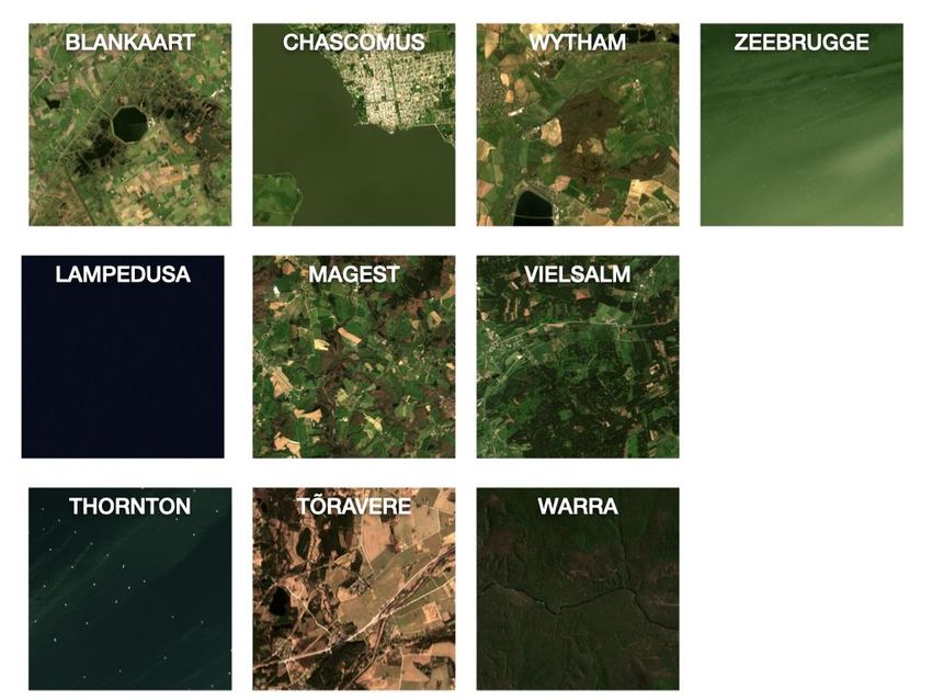
The Motivation for automated hyperspectral
10 years of MERIS water validation, including a few years of AERONET-OC…
                    Water reflectance 490nm               Sentinel-2A/B spectral response
Satellite (MERIS)

                         In situ
      Data acquisition must be                            Instrument must be
      AUTOMATED                                           HYPERSPECTRAL
[MERIS 3rd reprocessing data validation report, ACRI, 2012]
Data courtesy of PIs (D. McKee, K. Ruddick, D. Siegel, S. Kratzer) and AERONET-OC PIs (G.
Zibordi, G. Schuster, S. Kratzer,   B. Gibson),
                           (c) HYPERNETS              matchup
                                         Consortium, 2021           using
                                                          (RBINS, TARTU,     MERMAID
                                                                         SU, CNR, NPL, GFZ, CONICET)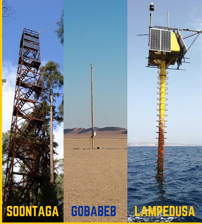
Motivation for water and land surface reflectance
                                                         Calibration by
                                                         space agencies
                                                                                               Top Of
                                                         1. TOA radiance                       Atmosphere (TOA)

  Radiometric    HYPERNETS                             Radiometric             HYPERNETS
  Validation                                           Validation

  2. Surface Reflectance                                2. Surface Reflectance                  Bottom Of
                                                                                                Atmosphere (BOA)
                                      WATER           LAND
 3W. Chlorophyll a, Suspended                          3L. LAI, NDVI, FAPAR, land class
 particle conc. etc.                                   types, etc.      Quality of user products
                              Water/Land                                           depends on quality of
                           Product Validation                                      upstream CAL and A/C
                   (c) HYPERNETS Consortium, 2021 (RBINS, TARTU, SU, CNR, NPL, GFZ, CONICET)
The Motivation for land surface reflectance
                                                                                [Morton et al, Nature, 2014]
RBINS Lesson learned from
ENVISAT/MERIS and ACIX-1...-2 :
• To compare atmospheric correction
  algorithm performance need
  surface reflectance data                                    "Correcting optical remote sensing
• Modelling atmospheric path                                  data for artefacts of sun-sensor
  reflectance from AERONET aerosol                            geometry is essential to isolate the
  measurements is not enough.                                 response of global vegetation to
                                                              seasonal and interannual climate
                                                              variability."
   Surface reflectance ESSENTIAL                               Need multiple sun/viewing geometries to
     (aerosols "nice to have")                                    develop and validate HDRF models

                     (c) HYPERNETS Consortium, 2021 (RBINS, TARTU, SU, CNR, NPL, GFZ, CONICET)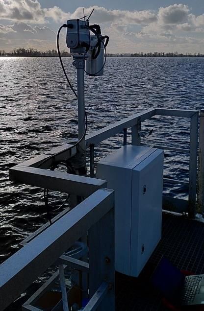
The H2020/HYPERNETS project
                           HYPERNETS                                                  HYPERNETS
                           multi-head                                                 Autonomous
                          hyperspectral                                                 System
                           Radiometer
                                                                            Radiometer          Calibration
                                                                                                monitoring
                                                                                                LED
                                                                                            Pan & Tilt

                       HYPERNETS                                                                  HYPERNETS
                                                                10 8
                          water                                                                       land
                        validation                   1                                             validation
                         network                                                                    network
                            phase 1                                1                                   phase 1
                                                         2 1
                                                                                                                 [2020 update]
                                                                       1
                                                                                                                 +PlanetDoves
                                                                                                                 +CHIME
                  Validation of surface reflectance at all spectral bands of all optical missions inc.           +PACE
                   Sentinel-2A&B, Sentinel-3A&B, MODIS-A&T, VIIRS, Landsat-8, Pléiades-2A&B,                     +...
[HYPERNETS
                          PROBA-V, CHRIS, ENMAP, PRISMA, SABIAMAR, etc. ... + nanosats
Proposal, 2017]
                              (c) HYPERNETS Consortium, 2021 (RBINS, TARTU, SU, CNR, NPL, GFZ, CONICET)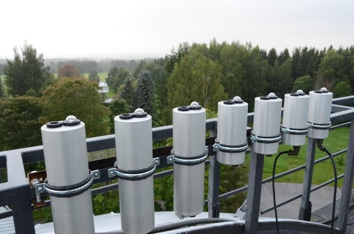
User data requirements - water+land
Strong need for in situ measurements to validate surface
reflectance:
• VISNIR: 380-1020nm at 5nm (or 1nm!)
• SWIR: 1000-2500nm at 5-10nm
• Temporal: Every ~10-30 minutes during daylight (if no power
limit)
• Spatial/angular:
LAND: Nadir+"full" nadir/azi up to 60°zen
WATER: 40° water/sky radiance, azi 90/135°
• + hemispherical and target cameras
• Direct/diffuse irradiance ratio
• Aerosols?
[Goyens et al (2018). Spectral Requirements for the
Development of a New Hyperspectral Radiometer
Integrated in Automated Networks - the Hypernets
Sensor. 1-5. 10.1109/WHISPERS.2018.8747259.]
(c) HYPERNETS Consortium, 2021 (RBINS, TARTU, SU, CNR, NPL, GFZ, CONICET)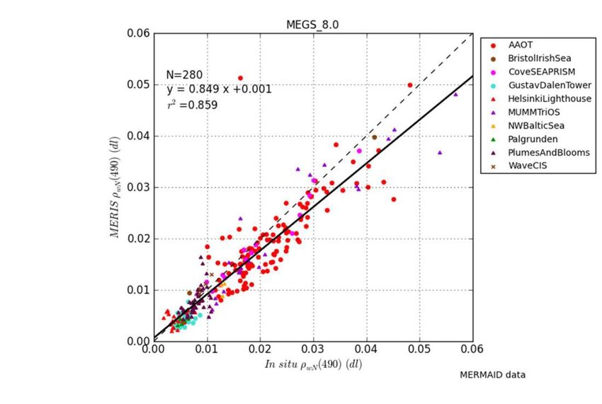
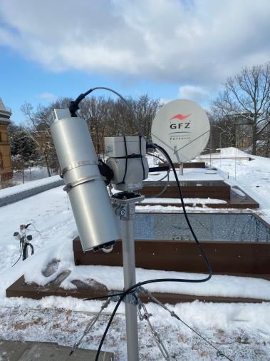
Radiometer instruments - status
 (requirement: radiometer must be mounted on pan-tilt for full zenith- and
 azimuth-pointing)
Existing TRIOS radiometer (2000) New HYPSTAR® radiometer
New "PANTHYR" system (2018) [TARTU] + pan-tilt sys [LOV]

Water reflectance design (400-900nm)                                 Land radiometer design has 380-1680nm
Old generation h/s radiometer, system mature                         New generation h/s radiometer
Land reflectance tests in 2021 (RBINS+NPL)                           1st field tests 2021, commercial 2023

[D. Vansteenwegen et al, "The pan-and-tilt hyperspectral                 Radiometer
radiometer system (PANTHYR) for autonomous satellite                                                     Calibration
validation measurements – prototype design and
testing", Rem Sens, 2019]
                                                                                                         monitoring LED
                                                                         Pan & Tilt                      + camera

                             (c) HYPERNETS Consortium, 2021 (RBINS, TARTU, SU, CNR, NPL, GFZ, CONICET)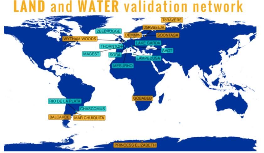
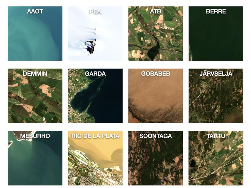
Validation Test sites

                                                         3*

                                                       BE

Land types
Forest
Grassland
Agricultural
Desert
Snow
(N+S
hemisphere)

Testing in 2021-22

                     (c) HYPERNETS Consortium, 2021 (RBINS, TARTU, SU, CNR, NPL, GFZ, CONICET)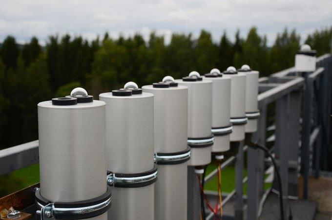
Sentinel-2 imagery of test sites (1/2)
[S2 Data from ESA/EU]
5km
! Reflectance/8
Reflectance/3
(c) HYPERNETS Consortium, 2021 (RBINS, TARTU, SU, CNR, NPL, GFZ, CONICET)
Sentinel-2 imagery of test sites (2/2)
[S2 Data from ESA/EU]
5km
(c) HYPERNETS Consortium, 2021 (RBINS, TARTU, SU, CNR, NPL, GFZ, CONICET)Status of HYPERNETS project
User requirements clarified (hyperspectral, automated, network)
Instrument designed+built, 7 prototypes delivered to partners
System (PC+pan/tilt+) designed+built, 7 prototypes delivered to partners
Land & water network processor prototype completed
Test sites prepared for first tests Dec2020-Mar2021
Satellite data processing: matchup automation and improvement A/C
Project finishes Oct 2022 ... but clear long-term need for this network of val sites
The HYPERNETS project is funded by the European Union’s Horizon 2020 research and innovation programme under grant agreement No 775983.
This communication represents only the authors’ views. The European Union is not liable for any use that may be made of the i nformation contained therein.
(c) HYPERNETS Consortium, 2020 (RBINS, TARTU, SU, CNR, NPL, GFZ, CONICET)Exciting times (the first HYPSTAR® deployments) ...
FOLLOW US on
https://twitter.com/Hypernets_H2020 !
(c) HYPERNETS Consortium, 2021 (RBINS, TARTU, SU, CNR, NPL, GFZ, CONICET)Practical challenges for long-term deployments Experience of running 2 AERONET-OC sites since 2012 + (with CNR and VLIZ) 3 WATERHYPERNET sites in 2019-20: Equipment – spiders, birds – atmospheric deposition during deployment – cable glands, cables, connectors – power supply limitations and outages – PCs have an internal clock battery – VPN connection + webcam very useful Logistics – Transport of equipment (customs if outside EU) – Calibration – Safety training and equipment (climbing, sea) – Site owners' priorities and changes Funding (R&D projects) – RBINS Thornton and Zeebrugge AERONET-OC have down periods It takes a lot of energy to keep a site running after the first two years
Conclusions
Surface reflectance data is essential for water and land
product validation
Autonomous hyperspectral network is most cost-effective
(multi-mission context)
Zenith- and azimuth-pointing enables full HDRF for land and
extra scenarios for water (as well as "parking" to protect)
Need for consolidation of protocols and uncertainty
estimation (water:FRM4SOC, land:FRM4VEG)

                                        The people who create the data and
                                                care for its quality
Priority:
Stabilise long-term funding of val site operations

 If no-one is paid to acquire data ... there will be no data to use
                 (c) HYPERNETS Consortium, 2021 (RBINS, TARTU, SU, CNR, NPL, GFZ, CONICET)
Any questions? (c) HYPERNETS Consortium, 2021 (RBINS, TARTU, SU, CNR, NPL, GFZ, CONICET)
You can also read