Present Status of AMSR2 on GCOM-W and AMSR3 on GOSAT-GW - Marine Data Center
←
→
Page content transcription
If your browser does not render page correctly, please read the page content below
Present Status of AMSR2 on GCOM-W and
         AMSR3 on GOSAT-GW
                  AMSR2 on GCOM-W

                Naoto Ebuchi (Hokkaido University/JAXA)
                       ebuchi@lowtem.hokudai.ac.jp
     Misako Kachi, Marehito Kasahara, Hideyuki Fujii, Rigen Shimada,
 Keiichi Ohara, Takashi Maeda, Kazuya Inaoka, and Yasushi Kojima (JAXA)
JAXA’s Earth Observation
                              Satellite/Instrument
Targets (JFY: Apr-Mar)                2014       2015       2016      2017       2018      2019        2020     2021      2022      2023       2024      2025
Disasters & Resources                [Land and disaster monitoring]                                                         [Land and disaster monitoring]
 JERS1/OPS, SAR (1992-1998)                          ALOS-2 / PALSAR-2                                                             ALOS-4/Advanced SAR
 ADEOS-I/AVNIR
                                                                                                                    [Land and disaster monitoring]
 ALOS/AVNIR2, PALSAR (2006-
 2011)                                                                                                                        ALOS-3/Advanced Optical

Climate System                     TRMM / PR      [Precipitation 3D structure]
• Water Cycle       with NASA
                                                GPM / DPR
 ADEOS-II/AMSR (2003)               with NASA                                                                                         [Wind, SST , water vapor,
 Aqua/AMSR-E (2002-2011)             [Wind, SST , water vapor, rainfall]                                                              precipitation]
                                          GCOM-W / AMSR2                                                                                 GOSAT-GW/AMSR3

• Climate Change                                                   [Vegetation, aerosol, cloud, SST, ocean color]
 ADEOS-I/OCTS (1996-1997)                                                                    GCOM-C / SGLI
 ADEOS-II/GLI (2003)                                                                                                       [Cloud and aerosol 3D structure]
                                                                                                                                    EarthCARE / CPR
                                                                                                                           with ESA
                                   [CO2, CH4]                                                                                          [CO2, CH4, CO]
                                   GOSAT / FTS, CAI                                                                                     GOSAT-GW/TANSO-3
• Greenhouse Gases            with MOE                                                [CO2, CH4, CO]                                   For MOE

                                                                           with MOE                           GOSAT-2

 Mission status:            Completed             On orbit             Under development

                    GOSAT-GW = Global Observing SATellite for Greenhouse gases and Water cycle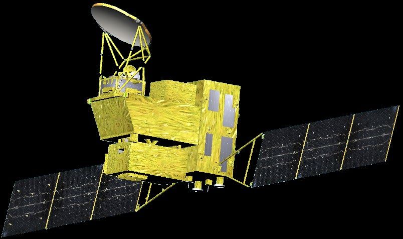
JAXA’s Mission of Passive Microwave
                       Sensors
               MOS-1                                            Aqua                      GCOM-W

                                       ADEOS-II                                                                         GOSAT-GW
               1987                              2002-2011                             2012-present                       after 2023
               MSR                     AMSR                                    Succeed to AMSR-E observation Continue & improve
                                                                               Improved onboard calibration AMSR-E/AMSR2 observation
                                                         AMSR-E
                                                                                            AMSR2                           AMSR3
Sensor              MOS-1/MSR         ADEOS-II/AMSR        Aqua/AMSR-E                 GCOM-W/AMSR2                     GOSAT-GW/AMSR3
Coverage        Direct receive only                                                       Global
Swath           317km                 1600km             1450km                 1617km                           > 1530km
Frequencies     2 (23,31)             9 (6.9,10,18,23,   6 (6.9,10,18,23,36,    6 (6.9/7.3,10.65,18,23,36, 89)   8 (6.9/7.3,10.25/10.65,18,23,
(GHz)                                 36,50,52,89)       89)                                                     36,89,166,183)
Polarization    Mixed V and H         V and H            V and H                V and H                          V and H (166/183 are V only)
Antenna Size    0.5m                  2.0m               1.6m                   2.0m                             2.0m
Spatial Res.    23km @31GHz           8x14km @36GHz      8x14km @36GHz          7x12km @36GHz                    7km x 11km @36GHz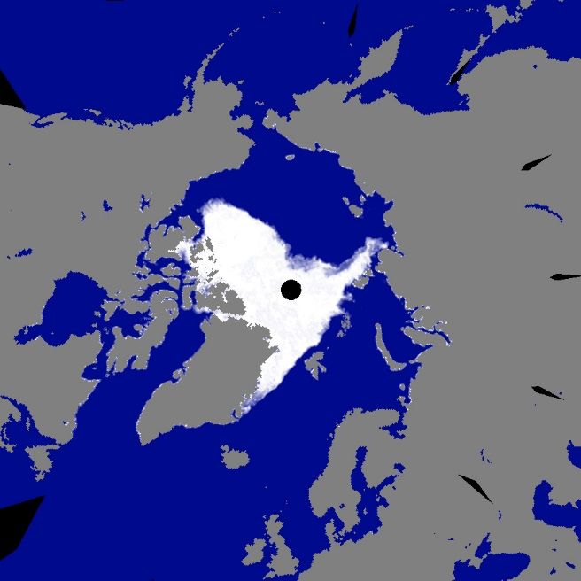
AMSR2 on GCOM-W
Successor of AMSR-E on Aqua and
AMSR on ADEOS-II.
Deployable main reflector system with
2.0 m diameter (1.6 m for AMSR-E).
Frequency channel set is identical to
that of AMSR-E except 7.3GHz
channel for RFI mitigation.
Two-point external calibration with
improved HTS (hot-load).
Add a redundant momentum wheel to
increase reliability.
GCOM-W1/AMSR2 characteristics AMSR2 Channel Set
Center Band Beam width [deg] Sampling
Scan and rate Conical scan at 40 rpm Freq. width Pol. interval
[GHz] [MHz] (Ground res. [km]) [km]
Antenna Offset parabola with 2.0m dia.
6.925/
Swath width 1450km (effective > 1600km) 350 1.8 (35 x 62)
7.3
Incidence angle Nominal 55 degrees 10.65 100 V 1.2 (24 x 42)
10
Digitization 12bits 18.7 200 and 0.65 (14 x 22)
23.8 400 H 0.75 (15 x 26)
Dynamic range 2.7-340K
36.5 1000 0.35 (7 x 12)
Polarization Vertical and horizontal 89.0 3000 0.15 (3 x 5) 5
https://www.gportal.jaxa.jp/gp/

                     AMSR2 Standard Products
                                 Resolutio   Release    Standard                       Validation        Latest
      Product        Coverage                                      Target Accuracy
                                    n        Accuracy   Accuracy                         Result         version
     Brightness                                                     ±1.0K (bias)
                      Global     5-50km       ±1.5K     ±1.5K                            < 1.4 K        Ver.2.2
    Temperature                                                    ±0.3K(random)
        Total
                      Global                  ±3.5       ±3.5
     Precipitable                 15km                              ±2.0 kg/m2         1.5 kg/m2        Ver.2.1
                      Ocean                   kg/m2      kg/m2
        Water
     Cloud Liquid     Global                  ±0.10      ±0.05
                                  15km                              ±0.02 kg/m2        0.04 kg/m2       Ver.2.1
        Water         Ocean                   kg/m2      kg/m2
                       Global                Ocean      Ocean
                      (except                ±50 %      ±50 %      Ocean ±20 %         Ocean 48%
     Precipitation                15km                                                                  Ver.2.1
                        high                  Land       Land      Land ±80 %          Land 86%
G                    latitude)               ±120 %     ±120 %
E     Sea Surface     Global                                          ±0.2 ºC            0.46 ºC
O                                 50km       ±0.8 ºC    ±0.5 ºC                                         Ver.3.0
     Temperature      Ocean                                         (zonal mean)     < 0.2 ºC (zonal)
     Sea Surface      Global                             ±1.0
                                  15km       ±1.5 m/s                ±1.0 m/s           0.96 m/s        Ver.3.0
     Wind Speed       Ocean                              m/s
                     Ocean in
       Sea Ice
                       high       15km        ±10 %     ±10 %          ±5%                 9%           Ver.3.0
    Concentration
                     latitude
     Snow Depth       Land        30km       ±20 cm     ±20 cm        ±10 cm             18 cm          Ver.2.1
     Soil Moisture    Land        50km        ±10 %     ±10 %          ±5 %              4 %vol             5
                                                                                                        Ver.3.0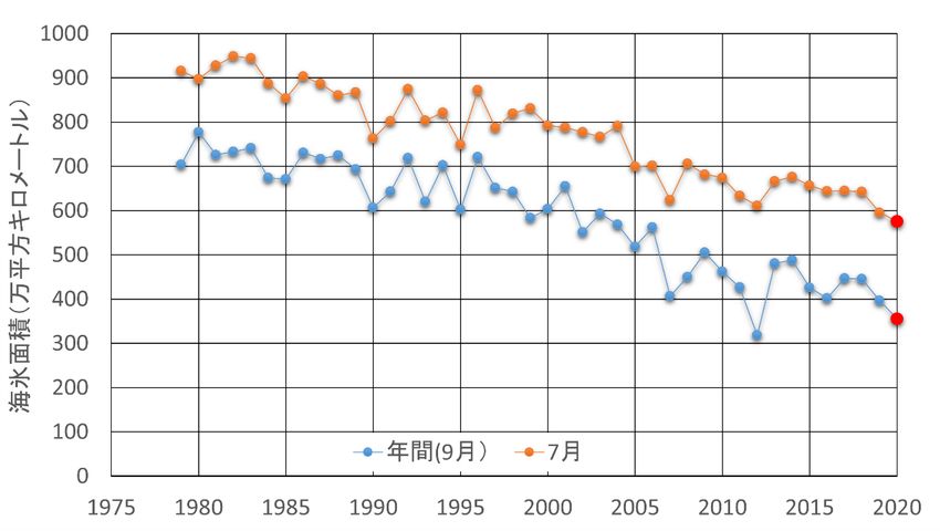
Snapshots from AMSR2
                                                                        1 Jan. 2013
Sea surface temperature                      Sea surface wind speed

Vertically-integrated water vapor             Precipitaion

             AMSR Viewer: https://www.eorc.jaxa.jp/AMSR/viewer/index_e.html
Monthly Averages (Dec. 2012)

Downloaded from “JAXA G-Potal” site (https://www.gportal.jaxa.jp/gp/top.html)

AMSR2 Research Products
     Released                  Not released          http://suzaku.eorc.jaxa.jp/GCOM_W/research/resdist_j.html
    Geophysical Parameters             Target (Release) Accuracy       Latest Validation Results    Product Status
     All-weather sea surface
                                          ±7 m/s (high winds)           ±3.95 m/s (>= 16 m/s)         Released
         wind speed (V3)
10 GHz sea surface temperature                                        ±0.48 degC (>= 9 degC)
                                              ±0.8 degC                                               Released
            (V4)                                                      ±0.62 degC (all temp.)
                                           Forest: ±3 degC                Forest: ±3 degC
 Land surface temperature (V1)                                                                        Released
                                     Nondense vegetation: ±4 degC   Nondense vegetation: ±4 degC
    Vegetation water content                   ±1 kg/m2                                               Validating
     High-resolution sea ice
                                                ±15 %                                                 Validating
         concentration
                                                                     > 88 % (Okhotsk, Bering sea,
     Thin ice detection (V1)           80 % (correct answer rate)                                     Released
                                                                             Hudson bay)
      Sea ice motion vector           ±3 cm/s (x & y components)                                      Validating

 Soil moisture & vegetation water        Soil moisture: ±8 %
                                                                                                     Developing
content by land assimilation model    Vegetation water: ±1 kg/m2
Integrated water vapor over land        ±6.5 kg/m2 (except ice &          RAOB:±3.5 kg/m2
                                                                                                      Released
              (V1)                         vegetation area)               GPS:±2.6 kg/m2
                                         Thin solid ice: ±10 cm
   Sea ice thickness (< 20 cm)                                                                       Developing
                                          Active frazil: ±3 cm
  Sea ice thickness (>= 20 cm)                 ±20 cm                                                Developing
     Multi-band sea surface
                                              ±0.8 degC                      ±0.47 degC               Released
       temperature (V4)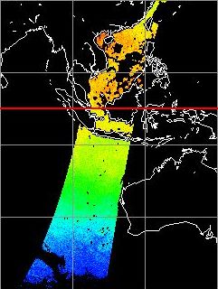
Precipitation Map composed from
Multi-Satellite MW Radiometer Obs.
               “GSMaP”
                        0.1 x 0.1 deg. resolution, 1-hour interval

                     Rain rate

  GSMaP (https://sharaku.eorc.jaxa.jp/GSMaP/)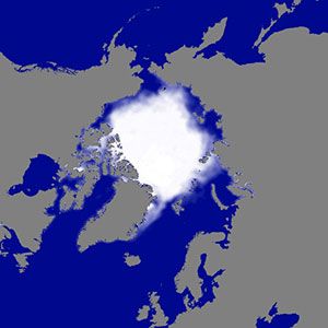
Global SST Monitoring
Global-mean SST anomalies ENSO monitoring
SST anomaly (oC)
AMSR
JMA Website Year
AMSR-2
AMSR-E
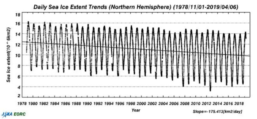
WindSatLong-term Sea Ice Record
AMSR series data is essential to monitor environmental changes in polar regions
Consistent dataset
AMSR-E AMSR2 from 1978 (SMMR) to
present (AMSR2)
• Global: Records the
minimum in Feb. 2018
• Arctic: Records the
minimum in Sep. 2012
• Antarctic: Records the
minimum in Mar. 2017
Average in Sep over 1980s Sep. 24, 2007 (AMSR-E) Sep. 16, 2012 (AMSR2)
(DMSP/SSMI/I) Third minimum record Minimum recordSecond Minimum in the Sea Ice Extent
Record in Sep. 2020
Yearly Arctic Sea Ice Extent in September and July
AMSR2 Sea Ice Concentration
on Sep. 13, 2020
Sea Ice Extent (104 km2)
In Sep. In Jul.
Yellow Line: Sea Ice Edge in 1980s AMSR series enable frequent (3-7 times per day), high-
resolution (15km) and all-weather observation of polar region.
Sea ice extent in the Arctic recorded the minimum value in the
Images by JAXA & NIPR (National record in July 2020, less than that in 2012 in that time.
Institute of Polar Research) In Sep. 2020, it recorded the yearly minimum value (3.55
million km2) and the second minimum in the record.Targets of AMSR3 Mission
• To produce long-term continuous data record for
climate studies
• To enhance operational utilization of near‐real time
data
Sep.1, 2012
weather forecast including typhoon/hurricane analysis
fishery in near-shore/off-shore regions
navigational assistance on arctic shipping route
• To obtain new geophysical parameter products
solid precipitation, water vapor over land, high-resolution
sea surface temperature, all-weather sea surface wind
speed and high-resolution sea ice concentrationCharacteristics of GOSAT-GW
Type Sun-synchronous, Sub-recurrent orbit
666 ㎞, recurrent cycle 3days
Orbit Altitude
(same as GOSAT)
AMSR3 MLTAN 13:30 ± 15 min (same as GCOM-W)
Mass 2.6 ton (Including propellant)
Power > 5.3 W
Design life > 7 years
Launch vehicle H-IIA rocket
TANSO-3
Mission data Direct transmission with X-band: 400 Mbps
downlink rate Direct transmission with S-band: 1 Mbps
TANSO-3
Instrument
AMSR3Specification of AMSR3 Instrument
Center
Conical scanning total power Band width Beam width
Sensor type frequency Polarization NEDT (1σ)
[MHz] (spatial resolution)
microwave radiometer [GHz]
Off-set parabolic antenna 6.925
H/V 350 < 0.34 K
1.8°
Antenna 7.3 (34 km x 58 km)
(φ2.0 m aperture)
1.2°
Swath width > 1530m 10.25 H/V 500 < 0.34 K
(22 km x 39 km)
1.2°
Quantization 12 bit 10.65 H/V 100 < 0.70 K
(22 km x 39 km)
55 deg. 0.65°
Incidence angle 18.7 H/V 200 < 0.70 K
except 89GB, 166G,183G (12 km x 21 km)
0.75°
X-polarization < -20dB 23.8 H/V 400 < 0.60 K
(14 km x 24 km)
< 0.70 K 0.35°
Beam efficiency > 90% 36.42 H/V 840
(TBD) (7 km x 11 km)
0.15°
Range 2.7-340K 89.0 A/B H/V 3000 < 1.20 K
(3 km x 5 km)
0.3°
Sampling interval 5-10km 165.5 V 4000 < 1.50 K
(4 km×9 km)
Data rate 87.4 kbps (average) 0.27°
183.31±7 V 2000×2 < 1.50 K
(4 km×8 km)
Designed lifetime 7 years 0.27°
183.31±3 V 2000×2 < 1.50 K
(4km×8km)
• Red indicates additions to AMSR2
• Blue indicates changes from AMSR2 due to avoid 5G RFIImpact of G-band Channels
Addition of 165 & 183 GHz channels for snowfall retrievals
and water vapor sounding
Requirement for G-band
Center Band Beam width
frequency Polarization width NEDT (1σ) (spatial
[GHz] [MHz] resolution)
0.3°
165.5 V 4000 < 1.50 K
(4 km×9 km)
0.27°
183.31±7 V 2000×2 < 1.50 K
(4 km×8 km)
0.27°
183.31±3 V 2000×2 < 1.50 K
(4 km×8 km)
AMSR2 Precipitation Product AMSR3 Precipitaion product
Solid precipitation
Without G-band With G-bandImpact of 10-GHz additional Channel
• 10-GHz channels with improved NEDT for high-resolution
SST
Beam width
Center frequency Band width
Polarization NEDT (1σ) (spatial
[GHz] [MHz]
resolution)
6.925 1.8°
H/V 350 < 0.34 K
7.3 (34 km x 58 km)
1.2°
10.25 H/V 500 < 0.34 K
(22 km x 39 km)
1.2°
10.65 H/V 100 < 0.70 K
(22 km x 39 km)
RX 100MHz (heritage)
10.0GHz
OMT LNA DIV Band width
-10.7GHz
RX 500MHz
New Current
band band
~500MHz 100MHz
10.0GHz 10.25GHz 10.65GHz
AMSR2 7 GHz-SST AMSR2 10 GHz-SST
Spatial resolution: 50km Spatial resolution: 30km
Better NEDTAMSR3 Products
Standard Product Research Product
Brightness Temperature (6.9-183GHz) (L1B) FOV-center Matched Brightness
Temperature (L1C)
Resampled Brightness Temperature (L1R)
High-resolution Brightness Temperature
Total Precipitable Water (over ocean & land) (6-10GHz) (L1H)
High-resolution Sea Surface Temperature
Integrated Cloud Liquid Water Content
(20km res.)
(over ocean)
Sea Ice Motion Vector
Precipitation (liquid & solid)
Land Surface Temperature
Sea Surface Temperature
(7GHz & 4-frequency) Vegetation Water Content
Sea Surface Wind Speed Thin Ice Detection
Soil Moisture Content & Vegetation Water
All Weather Sea Surface Wind Speed Content by Land Data Assimilation (L4)
Sea Ice Concentration Climate Data Record (CDR) for each
parameter
High-resolution Sea Ice Concentration
Soil Moisture Content
Snow Depth (snow depth & SWE) * Red indicates additions to AMSR2Current Status of AMSR3
Pre-Phase
Phase A Phase B Phase C Phase D Phase E Phase E Phase F
A
Concept Concept Approval Preliminary Critical Manufacturing Launch Initial Nominal Post-mission Ops.
Study Design of Plan Design Design & Testing Ops. Ops. Ops. (Incl. disposal)
MDR SRR SDR PDR CDR PQR
Jun. Dec. Oct.
2018 2018 2019
Scheduled to be launched in JFY2023
• Jun. 2018: Mission Definition Review (MDR)
• Dec. 2018: System Requirement Review (SRR)
• Oct. 2019: System Definition Review (SDR)
• Nov. 2019: Project Approval Review (management review)
• Dec. 2019: Started GOSAT-GW Project
• Feb.-Mar. 2021: GOSAT-GW Satellite System Preliminary Design Review (PDR)
(AMSR3 PDR was completed in Aug. 2020)You can also read