Profile of Biodiversity in India - Kalpavriksh
←
→
Page content transcription
If your browser does not render page correctly, please read the page content below
Chapter 4

Profile of Biodiversity in India

India, with 2.4% of the world’s area, has over 8% of the world’s total biodiversity, making it one of the 12 megadiver-
sity countries in the world. This status is based on the species richness and levels of endemism recorded in a wide
range of taxa of both plants and animals.This diversity can be attributed to the vast variety of landforms and climates,
resulting in habitats ranging from tropical to temperate and from alpine to desert (see Map 4.1). Adding to this is a
very high diversity of human-influenced ecosystems, including agricultural and pasture lands, and a diversity of
domesticated plants and animals, one of the world’s largest. India is also considered one of the world’s eight centres
of origin of cultivated plants. Being a predominantly agricultural country, India also has a mix of wild and cultivated
habitats, giving rise to very specialised biodiversity, which is specific to the confluence of two or more habitats.

The first part of this chapter takes a look at India’s ecosystem, its species, and its genetic diversity, both ‘natural’ and
‘domesticated’. The second part discusses the diverse uses of this biological diversity and the values attributed to it.

4.1 Components, Range, Global Position and Current Status of Biodiversity

4.1.1 Natural Ecosystems

Biogeographic Zones of India
The tendency to classify ecological regions, and plant and animal groupings, according to their geographical dis-
tribution and their essential similarities and differences, is not new. Traditional human communities did this on
the basis of their own understanding, though their knowledge was necessarily somewhat restricted in its geo-
graphical spread (Banwari 1992; Gurukkal 1989). Unfortunately, this aspect of traditional community knowledge
is not well appreciated or studied.

In modern times, biogeographical classification started in the latter half of the 19th century, with Blandford
(1870, 1901) and Elwes (1873) using the distribution of animals to classify bioregions, and Clarke (1898) followed
by Hooker (1907), using plant distribution to the same end. What distinguished most of these early attempts –
and indeed all except some recent efforts – was that they were either phytogeographic, i.e., based solely on plant
distribution, or zoogeographic, i.e., based only on animal distribution. An attempt to synthesise the two
approaches, or come up with a fresh classification based on the combination of plant and animal distribution, is
very recent, and has been prompted by the need to use such zonation in fixing conservation priorities. These
three kinds of approaches have been used or analysed by several authors recently, including Mani (1974), Puri et.
al., (1983), Meher-Homji and Mishra (1973), Menon (1990), and Rodgers and Panwar (1988).

One of the major recent approaches to classification of India’s ecosystems has been based on biogeography
(Rodgers and Panwar 1988). The major objective of this exercise was to develop a biogeographical classification
based on known information, which will enable conservation planning both at the national and state levels.This
classification uses four levels of planning:
a. The biogeographic zone, a large distinctive unit of similar ecology, biome representation, community and
    species;
b. The biotic province, a secondary unit within a zone, giving weight to particular communities separated by
    dispersal barriers or gradual change in environmental factors;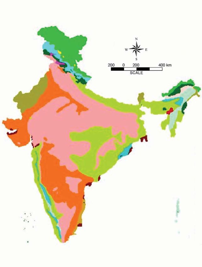
NATIONAL BIODIVERSITY STRATEGY AND ACTION PLAN, INDIA

                                                 Map 4.1 Bioclimatic Regions of India

  Source : Soil-Climate Database, NBSS, Nagpur

94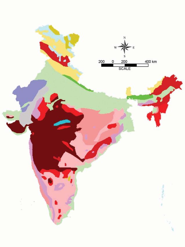
PROFILE OF BIODIVERSITY IN INDIA

c. The sub-division or region, a tertiary set of units within a province, indicating different land forms; and finally;
d. The biome, which is an ecological unit and not a biogeographic unit. A biome can be found in several bio-
   geographic zones or provinces.

                             Table 4.1 Biogeographic Zones of India and their Spatial Extent

 Zone No.            Zone Name                               Zone Area Sq km                    Percentage of India’s land area
 1.                  Trans-Himalaya                              184823                                       5.62
 2.                  Himalaya                                    210662                                       6.41
 3.                  Desert                                      215757                                       6.56
 4.                  Semi-Arid                                   545850                                     16.60
 5.                  Western Ghats                               132606                                       4.03
 6.                  Deccan Peninsula                           1380380                                     41.99
 7.                  Gangetic Plain                              354782                                     10.79
 8.                  Coasts                                       82813                                       2.52
 9.                  Northeast                                   171341                                       5.21
 10.                 Islands                                       8249                                       0.25
                     Grand Total                               3287263                                     100.00

 Source: Rodgers et. al., 2002

Rodgers et. al. (2002) recognise ten biogeographic zones divided into twenty-six biotic provinces in India: (see
Table 4.1 and Map 4.2 and 4.3) The zones are:

Trans-Himalaya
The Trans-Himalaya zone covers mainly the districts of Ladakh and Kargil in Jammu and Kashmir, and the Spiti
valley, Lingti plains (Lahaul valley), and Pooh tehsil (district Kinnaur) in Himachal Pradesh. Small areas in the
rain shadows of Nanda Devi range (Uttaranchal) and Kangchendzonga range (Sikkim) are also part of this
zone (Mehta and Julka 2001). The area is a distinct biogeographic unit with harsh climatic conditions and is
usually referred to as cold desert (Rodgers and Panwar 1998). The region is the most elevated zone on the
earth and varies from 2800 m in the Indus to over 7000 m in the Himalayan and Karakoram ranges (Mehta and
Julka 2001).

Himalaya
The Himalaya zone consists of an area of 21,0662 sq km, approximately 6.41% of the country’s total land surface.
It includes northwest Himalaya (Kashmir to the Sutlej river in Himachal Pradesh), west Himalaya (Sutlej river to
the Gandak river in Nepal), central Himalaya (Gandak river in Nepal through West Bengal and Sikkim to central
Bhutan) and east Himalaya (central Bhutan and Arunachal Pradesh).

Desert
The Indian desert is the northwestern boundary of India and covers mainly the western and northwestern region
of Rajasthan and part of Kachchh region of Gujarat in the southwest. It has an elevation of about 350-450 m
above sea level at the Aravalli range in the east, about 100 m in the south and west and about 20 m in the Rann
of Kachchh (Baqri and Kankane 2001).

Semi-Arid
This region is a zone of transition between the true desert in the west to the extensive communities of the
Deccan Peninsular India, to the south and east. This zone includes the Punjab plains, Delhi, Haryana, fringes of
Jammu and Kashmir, Himachal Pradesh, western edges of Uttar Pradesh, eastern Rajasthan, eastern Gujarat and
northwest Madhya Pradesh. The Semi-arid zone represents a characteristic savannah woodland and dry decidu-
ous and tropical thorn forest zone in Western India. The Aravalli System constitutes the heart of this zone, which
primarily supports two types of vegetation: Tropical Dry Deciduous Forest and Tropical Thorn Forest.

                                                                                                                                        95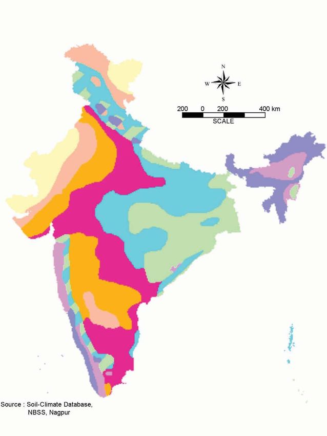
NATIONAL BIODIVERSITY STRATEGY AND ACTION PLAN, INDIA

                                     Map 4.2 Biogeographic Classification of India: Zones

 Source : Wildlife Institute of India, Dehradun

96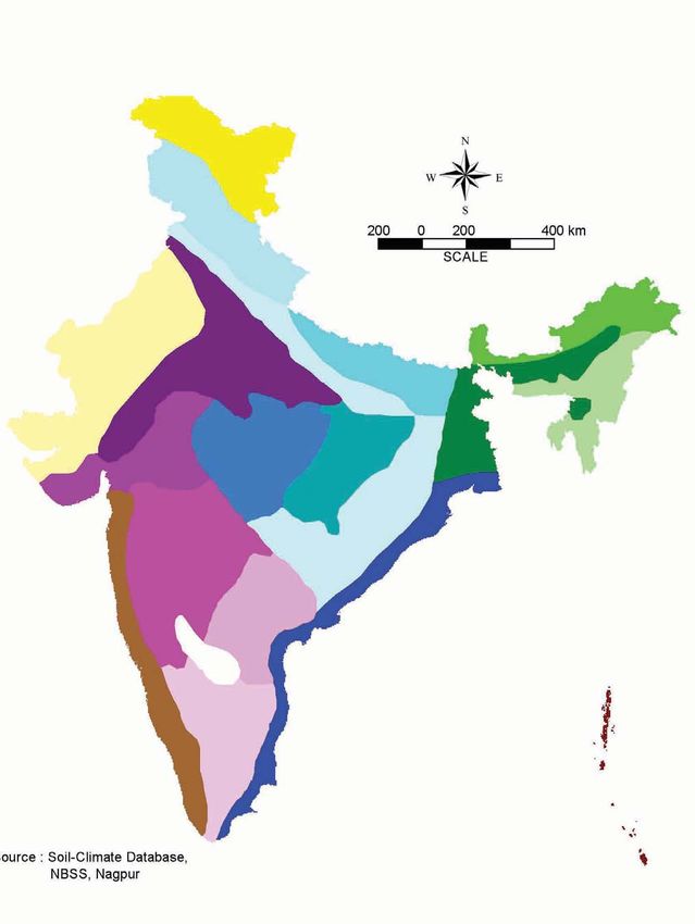
PROFILE OF BIODIVERSITY IN INDIA

                                Map 4.3 Biogeographic Classification of India: Provinces

Source : Wildlife Institute of India, Dehradun

                                                                                                                        97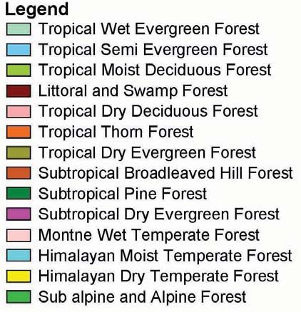
NATIONAL BIODIVERSITY STRATEGY AND ACTION PLAN, INDIA

               Western Ghats
               The Western Ghats stretch from the Tapti river in the north to Kanyakumari in the south, along the west coast of
               peninsular India through the states of Gujarat, Maharashtra, Goa, Karnataka, Tamil Nadu and Kerala
               (Lakshminarayana et.al., 2001).The Western Ghats zone is one of the 25 biodiversity ‘hotspots’in the world (Myers
               et. al., 2000) and is one of the major tropical evergreen forested regions in India, exhibiting enormous plant diver-
               sity. About 4000 species of flowering plants occur in the region, which harbours nearly 27% of the total flora in
               India (Nayar 1996). Among these, 1500 species are endemic (Mackinnon and Mackinnon 1986). The Western
               Ghats region is a major genetic estate with an rich biodiversity of ancient lineage.

               Deccan Peninsula
               The Deccan Peninsula biogeographic zone includes a major portion of the states of Maharashtra, Madhya
               Pradesh, Uttar Pradesh, Karnataka, Tamil Nadu, Andhra Pradesh, Orissa and Bihar. The zone is relatively homoge-
               nous and ranges from semi-arid to moist-deciduous/semi-evergreen type of climate.The central highlands com-
               prise the Vindhya and Satpura hill ranges, Chhota Nagpur Plateau, Eastern Ghats, Tamil Nadu Plains and
               Karnataka Plateau (Cherian 2001). The Vindhya and Satpura hill range are known for a rich diversity of flora.

               Gangetic Plains
               This zone includes the Gangetic divide, the Upper Gangetic plain, the Middle Gangetic plain and the Lower
               Gangetic plain (Hooker 1907). This zone is mostly under agriculture and supports dense human population
               stretching from eastern Rajasthan through Uttar Pradesh to Bihar and West Bengal. The Gangetic plain includes
               the area adjacent to Terai-Bhabar tracts in Uttar Pradesh, Bihar and West Bengal.

               Coasts
               The coastline of India stretches from Gujarat to Cape Comorin (Kanyakumari) in the west, and onwards from
               Cape Comorin to the Sundarbans in the east. The long stretch of coastline in the mainland has a very diverse set
               of biotic communities.

               North-East Region
               The north-east Indian biogeographic zone is most significant as it represents the transition zone between
               the Indian, Indo-Malay and Indo-Chinese biogeographic regions, as well as a meeting-place of
               Himalayan mountains with those of Peninsular India. It comprises eight states – Arunachal Pradesh, Assam,
               Manipur, Meghalaya, Mizoram, Nagaland, Sikkim and Tripura. The region acts as a biogeographic gateway for
               plant migration. In India, apart from the Western Ghats, Northeast India is one of the 25 biodiversity ‘hotspots’
               in the world (Myers et. al., 2000).

               Islands
               Islands are essentially in two major groups – the Lakshadweep islands and the Andaman group of islands. The
               Lakshadweep Islands are an archipelago of 27 small islands stretching from 8˚ to 12˚ N latitude and 71˚ to 74˚ E
               longitude in the Arabian Sea. They are 320 kms away from the Kerala coast. The Andaman and Nicobar Islands
               are an elongated north-south oriented group of 348 islands in the Bay of Bengal stretching for 590 km from 6˚
               to 13˚ N latitude and 92˚ to 93˚ E longitude.The Andaman Islands are about 190 km from Cape Negrais in Burma,
               the nearest point on the mainland. Five islands close together constitute the Great Andaman (300 km long), and
               the Little Andaman lies to the south. The Nicobar groups of Islands are separated from the Andamans as well as
               internally from each other by 800 m deep channels.

               4.1.1.1 Natural Terrestrial Ecosystems
               India, due to its varied physical features and its geographical location, experiences almost all kinds of climate,
               from tropical to alpine and from desert to humid. On the basis of temperature, the landmass of India can be
               broadly classified into four zones:
               a. Tropical zone, which is very hot round the year and does not have a winter,
               b. Sub-tropical zone, which is hot for most of the year but with a cool winter,
               c. Temperate zone, which has a warm summer and a pronounced winter, and,

98
PROFILE OF BIODIVERSITY IN INDIA
d. Arctic or Alpine zone, which has a short summer and a long and severe winter. (Natural Terrestrial Ecosystems
Thematic BSAP 2002)
Natural terrestrial ecosystems are of the following broad kinds: forests, grasslands, deserts and permanently
snow-bound areas. Within each of these, there is an immense diversity, which is briefly described below.
Forests
Diversity
According to FSI (2002), forest cover has been assessed to be 20.55% of the country’s geographical area. Of this,
dense forest areas cover 4,16,809 sq km (12.68 %) and open forests cover 2,58,729 sq km (7.87%). Forest cover
information of 589 of the 593 districts has been presented in the report, with statistics showing that Madhya
Pradesh has the maximum forest area of 77,265 sq km, followed by Arunachal Pradesh (68,045 sq km) and
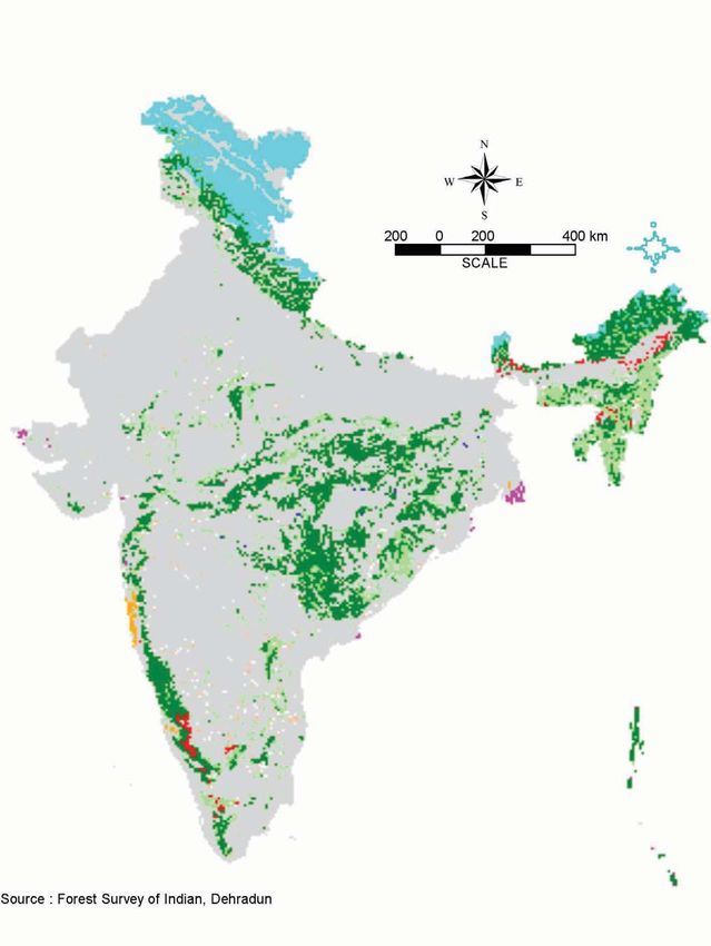
Chhattisgarh (56,448 sq km) (see Map 4.4). Defined simply as tree-or bush-dominated ecosystems, forests are
what most people think of when talking about a natural ecosystem. They are believed to contain most of the
earth’s terrestrial species biodiversity.Yet, though classified as one category for the sake of convenience, they dis-
play an internal diversity that is so large that often one forest type has almost no resemblance to another forest
type. Indeed the term ‘forests’ may even cover grassland and desert areas with sparse tree cover, resulting in
some confusion over ecological categorization of India’s terrestrial ecosystem.
There have been various approaches to classifying forest ecosystems. One of the most comprehensive and detailed
classifications of forests has been by Champion and Seth (1968), which is still in vogue in India.They adopted a hier-
archical system, which has five major forest types: a) Tropical forests, b) Montane sub-tropical forests, c) Montane
temperate forests, d) Sub-alpine forests, and, e) Alpine scrub. These are in turn classified into 16 major forest-type
groups and 221 minor forest-type groups. Brief descriptions of the 16 major forest type-groups are given in
Annexure 6 and their extent is given in Table 4.2 and Map 4.5 (Natural Terrestrial Ecosystems Thematic BSAP). The
recorded forest areas of the country have been classified as Reserve Forests (55%), Protected Forests (29%) and
Unclassed Forests (16%). But the vegetation of forests varies according to climate,rainfall, soil topography and other
habitat factors (http://envfor.nic.in/nfap/forest-distribution.html).
Table 4.2 Forest Types as Classified by Champion and Seth (1968)
S.No. Vegetation Type Area (Million ha) Percentage of Forest Area
1. Tropical wet evergreen forest 4.5 5.8
2. Tropical semi-evergreen forest 1.9 2.5
3. Tropical moist deciduous forest 23.3 30.3
4. Littoral and swamp forest 0.7 0.9
5. Tropical dry deciduous forest 29.4 38.2
6. Tropical thorn forest 5.2 6.7
7. Tropical dry evergreen forest 0.1 0.1
8. Sub-tropical broad leaved forest 0.3 0.4
9. Sub-tropical pine forest 3.7 5.0
10. Sub-tropical dry evergreen forest 0.2 0.2
11. Montane wet temperate forest 1.6 2.0
12. Himalayan moist temperate forest 2.6 3.4
13. Himalayan dry temperate forest 0.2 0.2
14. Sub-alpine 3.3 4.3
15. Moist alpine forest
16. Alpine forest
Total 77.0 100.0
Source: MoEF 1999c
99
NATIONAL BIODIVERSITY STRATEGY AND ACTION PLAN, INDIA

                                           Map 4.4 Forest Cover and Land Use of India

  Source : Forest Survey of India, Dehradun. 1999

100
PROFILE OF BIODIVERSITY IN INDIA

                                 Map 4.5 Forest Types of India

Source : Champion & Seth. 1968

                                                                                            101
NATIONAL BIODIVERSITY STRATEGY AND ACTION PLAN, INDIA

               Due to certain deficiencies in the classification system used by Champion and Seth (including the problem
               that it was based on extrapolation from some selected areas rather than on vegetation mapping of the whole
               country, and that it incorrectly distinguishes between southern and northern types), Gadgil and Meher-Homji
               (1990) proposed a more sophisticated classification based on detailed vegetation mapping by the French
               Institute, Pondicherry. Their system distinguishes 16 biogeographic zones and 42 vegetation types. The area
               under each of these, and the diversity of plants found in them, is given in Table 4.3.

                       Table 4.3 Area of each Vegetation Type and Its Floristic Diversity,
                                       Under Each Biogeographic Region

 VEGETATION TYPE                                        MAXIMUM AREA                      DIVERSITY OF PLANT
                                                          (‘OOO HA)                       SPECIES

 Region I. Wet Evergreen Forests of West Coast and Western Ghats
 1. Cullenia-Mesua-Palaquium                             645                              200
 2. Dipterocarpus-Mesua Palaquium                       1166                              1700
 3. Persea-Holigarna-Diospyros                           645                              Not available
 4. Montane shoal                                        123                              850
 5. Memecylon-Syzygium-Actinodaphne                      180                              400
 6. Bridelia-Syzygium-Terminalia Ficus                   212                              100

 Region II. Wet Evergreen Forest and Teak Forest Ecozone (Transitional Zone)
 1. Tectona- Lagerstroemia lanceolata-                  1240                              1500
    Dillenia-Terminalia paniculata
 2. Tectona- Terminalia                                   598                             450

 Region III. Teak Zone
 1. Anogeissus-Terminalia-Tectona                           7589                          800
 2. Tectona-Terminalia                                      7754                          400

 Region IV. Teak-Sal Transition Zone
 1. Terminalia-Anogeissus latifolia                         1915                          400
 2. Terminalia-Anogeissus-Cleistanthus                      2895                          Not available

 Region V. Sal Zone
 1. Shorea -Buchanania-Cleistanthus                         3222                          550
 2. Shorea- Cleistanthus- Croton                            1496                          400
 3. Shorea- Buchanania- Terminalia                          9178                          700
 4. Shorea- Terminalia- Adina                                 90                          700
 5. Shorea-Dillenia-Pterospermum                             170                          160
 6. Shorea-Syzygium operculatum -Toona                      3284                          850
 7. Toona-Garuga                                             172                          200

 Region VI. Hardwickia Zone
 1. Hardwickia binata-Anogeissus latifolia                  1514                          475

 Region VII. Albizia Amara Zone
 1. Albizia amara-Acacia                                     858                          400
 2. Anogeissus latifolia Chloroxylon- Albizia amara           17                          Not available
 3. Manilkara- Chloroxylon                                   131                          300

102
PROFILE OF BIODIVERSITY IN INDIA
Region VIII. Anogeissus Pendula Semi-Arid Zone of East Rajasthan
1. Acacia senegal- Anogeissus pendula 149 600
2. Acacia catechu- Anogeissus pendula 1671 Not available
3. Anogeissus pendula- A. latifolia 255 400
Region IX. Deccan Thorn Forest
1. Acacia-Anogeissus latifolia 27 Not available
Region X. Acacia-Capparis Scrub
1. Acacia-Capparis Negligible 500
Region XI. Indian Desert
1. Prosopis-Capparis-Zizyphus Negligible 550
Salvadora-Calligonum
Region XII. North-West Himalaya
1. Subtropical evergreen sclerophyllous forest 312 Not available.
2. Alpine steppe 232 Not available
Region XIII. North-West Himalaya to Eastern Himalaya
1. Subtropical Pinus roxburghii forest
2. Temperate mixed Oak and Coniferous forest 1288 Not available
3. Temperate coniferous forest 124 Not available
4. Sub-alpine forest 192 Not available
5. Alpine scrub 48 Not available
Region XIV. Eastern Himalaya and North-East India
1. Tropical wet evergreen forest 860 Not available
2. Tropical moist deciduous forest 1784 Not available
3. Subtropical broad leaved hill forest 148 Not available
4. Montane wet temperate forest 180 Not available
Region XV. Andaman and Nicobar Islands
Tropical wet evergreen forest 488 1000
Region XVI. Mangrove
Mangrove 58 Not available
Source: Adapted from Gadgil and Meher-Homji 1990
Current Status
(See also Section 5.1.1.1)
The earliest systematic assessment of forest loss can be made from 1972 onwards, derived from studies carried
out by the National Remote Sensing Agency (NRSA). NRSA’s figures for 1972-75 and 1980-82 showed an alarm-
ing reduction of forest cover by about 91,710 sq km, or about 2.79%. However, the NRSA figures were at variance
with the Forest Survey of India (FSI) figures for 1981-83, due to methodological differences. By reconciling their
methodologies, the two agencies came up with another figure that suggested that the situation was not so grim.
However, no attempt seems to have been made to derive new figures for 1972-75, using the reconciled method-
ology, so it is not possible to say how much forest, if any, was lost in the 1970s. The NRSA and FSI figures seem to
match with respect to the extent of dense forest in the early 1980s. If, therefore, the NRSA figure for dense forest
103NATIONAL BIODIVERSITY STRATEGY AND ACTION PLAN, INDIA
is taken to be accurate for the period 1972-75 also, then a loss of very large magnitude (over 100,000 sq km, or
3% of the total) can be discerned in the case of dense forests during this period. The total loss in dense forest is
more than the overall loss of forest cover, because, simultaneously, a large increase in the magnitude of open
forests took place (IIPA 1996).
Table 4.4 Forest Cover Estimates From 1987 to 1999
Assessment Year Data period Resolution of Forest Cover % of
Sensors meters (sq km) geographic area
First 1987 1981-83 80 640,819 19.49
Second 1989 1985-87 30 638,804 19.43
Third 1991 1987-89 30 639,364 19.45
Fourth 1993 1989-91 30 639,386 19.45
Fifth 1995 1991-93 36.25 638,879 19.43
Sixth 1997 1993-95 36.25 633,397 19.27
Seventh 1999 1996-98 23.25 637,293 19.39
Source: Anon 2000
Since 1987, the Forest Survey of India (FSI) is assessing the forest cover of the country biennially, using remote
sensing technology. The results of the last seven assessments are given in Table 4.4.
Table 4.5 Forest Cover as per 2001 Estimate
Class Area in sq km Percentage of Geographic area
Dense forest 416,809 12.68
Open forest 258,729 7.87
Total Forest Cover* 675,538 20.55
Scrub 47,318 1.44
Non-forest** 2,611,725 79.45
Total 3,287,263 100.00
*Includes 4,482 sq km under mangroves 0.14% of the country’s geographic area)
**Includes Scrub
Source: FSI 2002
The estimate in 2001 places the forest cover at 675,538 sq km, equivalent to 20.55 % of the geographical area of
the country.The dense forest constitutes 416,809 sq km (12.68%), open forest constitutes 258,729 sq km (7.87%)
and mangrove constitutes 4,482 sq km (0.14%) of the geographic area in the country (FSI 2002).
To get an idea of changes for each of the forest types described by Champion and Seth (1968) or the French
Institute (1990), an interesting analysis has been done by Gadgil and Meher-Homji for their 16-province, 42-type
classification. Basing their analysis on the extensive mapping done by the French Institute in most parts of the
country except the Himalayas, and supplementing these data with the work of Schweinfurth (1957), the maps of
the National Atlas Organisation (1990) and the Forest Survey of India satellite imagery, they have roughly esti-
mated actual area covered by each vegetation type as a percentage of its potential area (assuming no external
hindering factor). Actual area has further been divided into:
a. Plesioclimax (approximating climax vegetation), and,
b. All physiognomies (climax and degraded stages).
A summary of the results is presented in Table 4.6.
104PROFILE OF BIODIVERSITY IN INDIA
Table 4.6: Area (Percentage of Potential) Under Plesioclimax and Under Other
Degraded Physiognomies of Vegetation
S.No. Vegetation type % under % under other degraded
Plesioclimax Physiognomies
1. Tropical wet evergreen forest 70 90
of Andaman-Nicobar
2. Shorea_Buchanania-Terminalia 15 90
3. Bridelia-Syzygium-Terminalia-Ficus 41 77
4. Shorea-Syzygium operculatum-Toona 25 66
5. Persea-Holigarna-Diospyros 60 60
6. Mangrove 30 60
7. Temperate mixed oak and – 55
coniferous forest of Himalayas
8. Dipterocarpus-Mesua-Palaquium 22 52
9. Subtropical broad-leaved – 49
forest of Eastern Himalayas
10. Shorea-Terminalia-Adina 37 47
11. Tectona-Terminalia 15 45
12. Shorea-Buchanania-Cleistanthus 14 39
13. Montane Shola 8 35
14. Tropical moist deciduous forest of NE India – 33
15. Tectona-Terminalia-Adina-Anogeissus 27 33
16. Cullenia-Mesua-Palaquium 18 30
17. Terminalia-Anogeissus-Cleistanthus 9 28
18. Tectona-Lagerstroemia-Dillenia-T. paniculata 18 25
19. Memecylon-Syzygium-Actinodaphne 12 25
20. Subtropical evergreen sclerophyllous – 23
forest of NW Himalaya
21. Subtropical Pinus roxburghii forest – 19
of Himalayas
22. Anogeissus-Terminalia-Tectona 5 18
23. Toona-Garuga 17 17
24. Terminalia-Anogeissus latifolia 6 16
25. Tropical evergreen forest of NE India – 15
26. Temperate coniferous forest of Himalayas – 14
27. Shorea-Cleistanthus-Croton 7 14
28. Hardwickia binata-Anogeissus latifolia 12 13
29. Acacia catechu-Anogeissus pendula 8 11
30. Alpine scrub of Himalayas – 9
31. Shorea-Dillenia-Pterospermum 6 9
32. Montane wet temperate forest – 6
of eastern Himalayas
33. Albizia amara-Acacia 5 6
34. Anogeissus pendula-Anogeissus latifolia 2 5
35. Manilkara-Chloroxylon 0.2 5
36. Alpine steppe of NW Himalayas – 4
37. Subalpine forest of Himalayas – 4
105NATIONAL BIODIVERSITY STRATEGY AND ACTION PLAN, INDIA
38. Acacia senegal-Anogeissus pendula 1 4
39. Acacia-Anogeissus latifolia 0 0.3
40. Acacia-Capparis 0 0
41. Prosopis-Capparis-Zizyphus-Salvadora 0 0
42. Anogeissus latifolia-Chloroxylon- 5 –
Albizia amara
Source: Gadgil & Meher – Homji, 1990
The data presented is the area under Plesioclimax and under Other Degraded Physiognomies of vegetation, as a percentage of the potential area of each
vegetation type. (Note: This table is ordered in decreasing order of percentage area under all physiognomies; the symbol ‘-’ denotes a lack of information.)
As can be seen, the status of different forest types in India is mixed, some having declined sharply in extent, others
still relatively secure. Almost completely eliminated, along with much of their constituent biodiversity, are the dry
zone vegetation types. For instance, the Acacia-Capparis Scrub, characteristic of the driest regions of the Deccan
plateau of Andhra Pradesh, Karnataka, Maharashtra, Saurashtra in Gujarat, and the plains west of the Aravalli hills in
Rajasthan, has been wiped out except for small patches like the Velavadar National Park in Gujarat.The Thorn Forest
of the semi-arid zones of the Deccan plateau, once covered by Acacia nilotica and Anogeissus latifolia, is also almost
exterminated. Other studies too have suggested that semi-arid and arid zones of India are the country’s most
severely degraded habitats (see, for instance, Daniels et. al., 1990). But several Himalayan tracts are also severely
threatened, including the Alpine steppe of the North-west Himalayas, the Sub-alpine forest of northern Uttar
Pradesh and other parts of the Himalayas, and the Montane Wet Temperate Forest of eastern Himalayas. Indeed, if
the stage of plesioclimax is considered to be the relatively intact stage of a forest type, only the Tropical Wet
Evergreen Forest of Andaman and Nicobar Islands, and the semi-evergreen and moist deciduous Persea-Holigarna-
Diospyros forest of the Western Ghats, with over 50% of their area under plesioclimax, can be considered secure.
Gadgil and Meher-Homji (1990) have also pointed out that almost all forest types have faced considerable frag-
mentation due to the spread of human settlements and agriculture, biotic and industrial pressures, and the inva-
sion of exotics. According to their assessment, the median size of the largest remaining patch of each vegetation
type is about 1100 sq km, compared to a potential median area of 49,000 sq km. Using the estimates of species
loss given by scientists working on the problem of fragmentation in other countries (Soule and Wilcox 1980),
Gadgil and Meher-Homji calculate that the process of habitat loss and fragmentation already set in motion in
India is likely to lead to an extinction of over a third of the estimated 150,000 species of plants and animals in the
near future. These estimates do not take into account the fact that a considerable amount of this diversity is not
in forest areas, but in other habitat types; however, given the degradation and loss of the latter as well, the figure
may not be too much off the mark. Even if it is somewhat of an over-estimate (as those challenging the Soule
and Wilcox formulae may claim), the total loss is still of staggering magnitude.
Grasslands
Diversity
Grasslands, variously called steppes, prairies, cerrados, pampas, savannahs, velds and rangelands in different
parts of the world, are vegetation types with predominance of grass and grass-like species. In India, high-altitude
grasslands of the Himalaya have been referred to as marg or bugiyal, and in Ladakh as tsang. Grasslands are plant
communities with a more or less continuous layer of graminoids (grasses and grass-like plants), with or without
a discontinuous layer of trees or shrubs. Grasslands are often associated with marked seasonality in precipitation,
occurrence of fire and grazing by ungulates. Bamboo forests, though technically dominated by grasses, are not
included under grasslands as they physically and in other respects resemble forests, and are usually mixed with
a significant number of trees. Some research on this ecosystem was done by Yadava and Singh (1977), Singh and
Gupta (1993), Pandey and Singh (1991), Melkania and Singh (1989) and Singh et. al., (1983).
The grassland community builds an entirely different type of soil as compared to a forest, even when both start
with the same parent material. Since grass-plants are short-lived as compared to trees, a large amount of organic
106PROFILE OF BIODIVERSITY IN INDIA
matter is added to the soil. The first phase of decay is rapid, resulting in little litter, but much humus. Humification
is rapid but mineralization is slow. Consequently grassland soils may contain 5-10 times as much humus as forest
soils (Odum 1971).
As of 1992, the grassland coverage of the earth’s terrestrial area was about 27% (Groombridge 1992). For India,
Olson et. al., (1983) put the cover of grass and shrub land at 12% of the total landmass; however, the Planning
Commission (PC 1988) estimates grassland coverage at 3.7%, and scientists at the Indian Grasslands and
Fodder Research Institute, Jhansi, give an estimate of 3.9%, or about 120 lakh (12 million) hectares (Singh
and Misri 1993). The discrepancy in figures between Indian sources and Olson may not be due only to the
difference in period of estimation (a full decade’s gap), but also due to difference in definition (Olson has
included shrubland in his category). The working figure for this report will be the 12 million ha given by Singh
and Misri (1993).
The distribution of grasslands in India is quite uneven. For instance, in the western region, Rajasthan and Gujarat
have 5.4% and 3.5% respectively of their land area under grasslands. In the eastern region, grasslands and pas-
tures comprise less than 1% of the area, except in Sikkim, where they cover 13.3% of the land (IIPA 1996). The
grasslands include such dissimilar ecosystems as the semi-arid pastures of the western part of the Deccan penin-
sula, the humid, semi-waterlogged tall grassland of the Terai belt, the rolling shola grasslands of the Western
Ghats hilltops, and the high-altitude alpine pastures of the Himalayas.
The vast majority of grasslands in India – with the possible exception of those abutting the shola forests of the
Western Ghats, those occurring in the alpine region of the Himalaya, and the Lasiurus sindicus grasslands of
western India – owe their origin to destruction of forests and abandonment of cultivation, and have become
widespread in a variety of habitats as seral communities maintained under the impact of such biotic factors as
grazing, cutting and burning. Some ecologists point out, however, that the presence of grassland-dependent
species like Nilgiri tahr, floricans etc. is evidence of the natural presence of grasslands (Asad Rahmani, personal
communication 2002). Extensive areas in the sal belt, which have been prevented from regeneration into forest
by fire, grazing, cutting and general deterioration of soil, now carry high savannah grasses, as on the higher
phantas of Kheri and the chaors of Haldwani in Uttar Pradesh (both terms mean grass clearings within forests).
Extensive grass downs are found in Nilgiri, Palni and Annamalai plateaus in South India, where grazing and
burning are regularly practiced.
Marked differences in habitats (e.g. physico-chemical characteristics of soil, topography, etc.), age and mode of
origin, and intensity of biotic processes all result in an array of very diverse grassland communities. Because of
their occurrence within and adjoining forest and savannah lands, the grasslands are especially valuable habitats
for wildlife, and support an extremely high population of livestock (Natural Terrestrial Ecosystems Thematic BSAP).
For example, alluvial grasslands support hog deer, wild water buffalo, swamp deer or barasingha and Indian rhi-
noceros; arid grasslands support black buck, wild ass and chinkara; high-altitude grasslands support ibex,Tibetan
wild ass, tahr, goral, argali, urial, chiru, Tibetan gazelle and bharal; secondary grasslands support black buck, chi-
tal, gaur and chinkara. Grasslands also occupy canopy gaps in open forests and form distinct associations. In arid
and semi-arid regions, the association of grasslands with thorn forests and shrub vegetation often imparts a
savannah-like aspect to the landscape. Grasslands are closely related to agro-ecosystems as they provide a rich
gene pool, including species which serve as collateral hosts for many plant diseases, insects, and nematodes.
Also, most of the agriculture in India depends on animal power, which gets its energy supply from the grasslands
through grazing or stall-feeding of dried and cured herbage.
On the basis of a country-wide survey of grasslands in India, Dabadghao and Shankarnarayan (1973) have recog-
nised five broad grass cover types:
1. Sehima-Dichanthium Type: Spread over peninsular India, southwest Bengal, southern Bihar, and the south-
ern hilly plains of Uttar Pradesh and Rajasthan, this cover type consists of 24 perennial grasses, several annu-
al grasses, and 129 other herbaceous species including 56 legumes. Key species include Sehima nervosum,
Heteropogon contortus, Dichanthium annulatum and Themeda triandra. As Rahmani (1992) notes, Sehima-
107NATIONAL BIODIVERSITY STRATEGY AND ACTION PLAN, INDIA
Dichanthium cover occupies the largest area of grasslands in the country. The rainfall varies from 300 mm in
Kachchh to 6,350 mm in the Western Ghats.The best development of Sehima-Dichanthium cover is seen with
a rainfall of 500 to 900 mm.Therefore, the semi-arid tracts of Maharashtra, Gujarat, Andhra Pradesh, Karnataka
and Tamil Nadu are typical examples of this cover type. When the Sehima-Dichanthium cover is subjected to
grazing, these communities are replaced by Chrysopogon and Bothriochloa communities respectively.
Rollapadu grassland of Andhra, Gnanganga dry grassland of Buldhana district in Maharashtra, Sailana grass-
land in Ratlam district of Madhya Pradesh and Velavadar salt grassland of Gujarat are some of the important
sites in this zone. As these grasslands are not at the climax stage and are affected by various edaphic factors,
floral species composition varies. The floral composition also depends on the degree of protection to the
grassland from fire and livestock grazing.
2. Dichanthium-Cenchrus-Lasiurus Type: Spread over northern parts of Gujarat, Rajasthan, western Uttar
Pradesh, Delhi, and semi-arid Punjab, this type contains 11 perennial grasses, 19 legumes and 26 other herba-
ceous plants. Key species include Dichanthium annulatum, Cenchrus ciliaris, C. biflorus, Lasiurus sindicus and
Atylosia scarabaeoides.The rainfall ranges from about 100 mm in the extreme west to about 750 mm towards
the eastern boundary of this cover type. Several plant communities occur, depending upon the habitat con-
ditions and intensity of biotic pressure. Rahmani (1992) notes that one of the largest extant grasslands of the
country is present in this area – the Sewan (Lasiurus sindicus) grassland in Jaisalmer, which is 170 km long and
25 to 35 km wide. Another important grassland is Banni in Kachchh district.
3. Phragmites-Saccharum-Imperata Type: Spread over the alluvial plains of the Ganga and the delta plains of
West Bengal and the Assam Valley, this consists of 19 perennial grasses, 16 legumes and 40 other herbaceous
plants. Key species include Phragmites australis, Saccharum spontaneum, Imperata cylindica and
Desmostachya bipinnata. The water table is high and soil is poorly drained. Rainfall is moderate (500 mm) to
high (up to 5000 mm) in this region.Though this region contains some of the wet grasslands of the Terai and
Bhabar, some areas are semi-arid, especially in southern Uttar Pradesh and Bihar due to the north-south
moisture gradient. The wet grasslands of the seasonally flooded valleys of the Terai and northeast India are
very ancient, which is proven by the presence of diverse herbivore fauna: elephant, rhinoceros, barasingha
and hog deer, indicating the grassland’s stable history (Rahmani 1992).
4. Themeda-Arundinella Type: Covering the northern plains to the outer humid hills of the Himalayas, in
Assam, Manipur, West Bengal, Uttar Pradesh, Punjab, Himachal Pradesh, and Jammu and Kashmir, this type
contains 16 characteristic perennial grasses and 34 other herbaceous plants including 9 legumes. Key species
include Themeda anaethera, Arundinella bengalensis, Bothriochloa bladhii, B. pertusa, Heteropogon contortus
and Chrysopogon fulvus.
5. Temperate-Alpine Type: Spread over the higher altitudes of Jammu and Kashmir, Uttaranchal, Himachal
Pradesh, West Bengal, and Assam, this contains 35 characteristic perennial grasses, 6 legumes, and 62 other
herbaceous plants. Key species include Dactylis glomerata, Bromus inermis, Festuca pratense and Themeda
anaethera. Based on the altitude gradient, several community types have been recognized. In the Central
Himalaya, five distinct types of bugiyals (high-altitude grasslands) have been identified locally by the semi-
nomadic bhotias (Melkania 1983, Melkania and Tandon 1988). These are:
i. Dug or dudh bugiyal – dominated by Euphorbia stracheyii (Dudh bug), common on drier slopes;
ii. Bas bugiyal – dominated by Sassurea graminicola (Bas bug) on east facing slopes above 4200 m elevation;
iii. Mot bugiyal – dominated by Danthonia cachemyriana (Mot bug or phiji ghas) and Phleum alpinum on
slopes above 3200 m;
iv. Dhania bugiyal – predominated by Cortia lindleyi (Dhania bug) in shady and marshy locations; and;
v. Dhati bugiyal – characterized by preponderance of Kobresia spp. (Dhati bug) between 3000 to 4000 m.
In India, grasses form the largest family of flowering plants. Out of an estimated 17500 species of flowering
plants, about 1200 are grasses. About 360 grass taxa (almost 30%), are endemic to India. 172 endemics occur in
the peninsular region, 56 in the north-east, 30 in the north-west, 5 in the western arid regions, 12 in the lower
Gangetic plain, 4 in the Andaman and Nicobar Islands, and 50 spread over more than one of the above regions.
It has been estimated that presently about 1055 species occur naturally in India and about 130 other species
have been introduced; some of the latter are now naturalised (Jain 1986).
108PROFILE OF BIODIVERSITY IN INDIA
Current Status
(see also Section 5.1.1.1)
Unfortunately, due to a greater neglect than even that suffered by forests, the status of grasslands is not so well
known. Worldwide, it is estimated that from an original coverage of about 40% of the earth’s land surface, grass-
lands have come down to anything between 16 and 27% (Groombrige 1992). Parallel figures for India are not
available, largely because no base data exists for grassland coverage in the past, but also because grassland mon-
itoring has been virtually non-existent even in the recent past. It is well-known that the semi-arid grasslands of
western India are severely threatened by ‘development’ projects (like the Indira Gandhi Canal) and overgrazing,
and are now restricted to a few small protected tracts only. This is also the case with the tall swamp grassland of
the Terai belt, which has been seriously threatened with fragmentation and conversion to various human-dom-
inated land uses. Because of the large livestock population, most of the grasslands remain under severe grazing
pressure throughout the year. Many areas, especially the high-altitude grasslands and the grasslands of the arid
and semi-arid regions, suffer from seasonal grazing stress caused by migrating livestock.
Box 4.1 Rock Outcrops
India has several types of rocky habitats dominated by herbaceous or shrubby vegetation in ‘natural’ or ‘climax’ stages.These
‘rock outcrops’ can be defined as portions of mostly freely-exposed bedrock protruding above the soil level due to geolog-
ical activities. They are prominent growth sites for ‘azonal plant communities’, which are characterized by particularities of
their underlying substrate with soil typically lacking.
The most prominent rock outcrops in India are as follows: Lateritic plateaus, common in western India in high-rainfall areas.
Cliffs form a distinct feature in all the hilly areas, e.g. in the Western Ghats. Inselbergs are isolated rock outcrops rising
abruptly above their surroundings and are seen throughout south India and Bihar. Outcrops of basalt, limestone, sand-
stone and quartzite are locally common in certain parts.
Despite the fact that rock outcrops form striking landscape elements throughout India and often have an immense cul-
tural and religious importance, not much is known about their floristic and faunistic diversity. In general, tropical rock out-
crops (in particular inselbergs; see Porembski and Barthlott 2000), have only relatively recently become objects of interest
to biologists.
Rock outcrops are characterized by extreme micro-climatic conditions and form centers of diversity for highly specialized
plant life-forms which are well adapted to freely exposed, seasonally dry growth sites. Some of the plant adaptive strategies
commonly observed on rock outcrops are: carnivory/insectivory, annuals, poikilohydry (desiccation tolerance), geophytes,
lithophytes, succulents as well as hydrophytes and mat-forming species. Using physiognomic criteria, a number of habitat
types can be distinguished (e.g. cryptogamic crusts, ephemeral flush vegetation, monocotyledonous mats, rock pools).
Based on preliminary observations it can already be concluded that the flora of rock outcrops in India is clearly dis-
tinct from that of other regions. The highly specific nature of adaptations of the organisms have led to a high percentage
of endemism in certain regions (e.g. Western Ghats). The fauna associated with rocky habitats include insects, fish, amphib-
ia, reptiles, birds and small mammals. Biodiversity studies of rock outcrops in other parts of the world indicate that outcrops,
particularly inselbergs, are like ‘terrestrial islands’.
Rock outcrops feature prominently in human landscapes. Most inselbergs have temples on the hill tops (the best-known
example is Shravanbelgola shrine in Karnataka). Natural rock pools formed on inselbergs and plateaus are important in vil-
lage water management. Many rocky outcrops are centers for religious, aesthetic or nature tourism.
Although floristic inventories are available for a few rock outcrops, they are mostly not described as separate ecosystems. Owing
to the lack of published literature, a comparison with global biodiversity studies of rock outcrops is impossible at present.
Source: Porembski and Watve 2003
109NATIONAL BIODIVERSITY STRATEGY AND ACTION PLAN, INDIA
Deserts
Diversity
Deserts (as distinct from desertified areas) are natural ecosystems characterised by very low rainfall (PROFILE OF BIODIVERSITY IN INDIA
The Great Rann of Kachchh and the Little Rann of Kachchh, with an area of about 16780 sq km and 5180 sq km
respectively, constitute the entire Rann of Kachchh.The average altitude is about 15 m above mean sea level, and
it thus appears like a table-top surface. Ecologically, it represents one of the largest seasonal saline wetland areas,
having water depth ranging from 0.5 to 1.5 m. The Little Rann of Kachchh is world famous for the last remaining
population of the endemic Wild Ass, and almost the entire Little Rann is covered under Wild Ass Sanctuary (WAS)
to protect this species (Kachchh Sub-state BSAP). The Rann fills up with clay and silt discharged from several sea-
sonal rivers originating in the Aravalli Hills: Luni, Rakhari, Bhukhi, Banas, Nachhu, Demi, etc. These rivers flow
through the Rann, and spread out into the vast floodplain in the monsoons to add to the inundation by the sea.
The result is a massive, shallow sheet of water, 1-7 feet deep (Sinha and Goyal 1993), which covers the area for 2-
3 months of the year.The only parts of land which escape this inundation are the low hillock islands (bets) of non-
saline soil, sprinkled throughout the desert, which become the refuge of a large number of animals as well as the
nomadic herding community of Maldharis during the floods.These bets harbour some of the few concentrations
of vegetation in the Rann.
Box 4.2 Vertebrate Fauna of the Salt Desert
Common fishes – Cirrhinus mirgala, Lobeo boggut, L. fimbriatus, L. potail, Punitus arulius, P. Sarana, Sciaena spp, Sciaenoides
spp., Polynemus spp., Polynemus indicus, catfishes, pomfrets, elasmobranchs, etc.
Common amphibians – Indian bullfrog (Rana tigrina), Skipper frog (R. cyanophlyctis), Cricket frog (R. limnocharis), Green frog
(R. hexadactyla), Bufo stomaticus, Ornate frog (Microhyla ornate).
Common reptiles – Banded gecko (Cyrtodactylus kachhensis), Brook’s gecko (Hemidactylus brooki), Bark gecko (H.
leschenaulti), Northern house gecko (H. flaviviridis), Fan-throated lizard (Sitana ponticeriana), Common garden lizard (Calotes
versicolor), Agama agilis, Short-tailed agama (A. minor), Little skink (Mabuya macularia), Common skink (M. carinata), Skink
(Ablepharus grayanus), Snake skink (Riopa punctata), Yellow-bellied mole skink (Eumeces taeniolates), Sandfish (Ophiomorus
raithmahi), Indiana fringe-toed lizard (Acanthodactylus cantoris), Jerdon’s snake-eye (Ophisops jerdoni), O. microlepis,
Common Indian monitor (Varanus bengalensis), Indian flap-shell turtle (Lissemys punctata punctata), Chameleon
(Chamaeleon zeylanicus), Jerdon’s worm snake (Rhamphotyphlops braminus), John’s earth boa (Eryx johni), Checkered keel-
back (Xenochrophis piscator), Leith’s sand snake (Psammophis leithi), Himalayan sand snake (P. condaranus), Common Indian
krait (Bungarus caeruleus), Indian cobra (Naja naja), and Saw-scaled viper (Echis carinatus).
Common birds – Black Stork (Ciconia nigra), Glossy Ibis (Plegadis falcinellus), Flamingo (Phoenicopterus ruber roseus), Little
brown dove (Streptopelia senegalensis), Indian ring dove (S. decaocta), Crow pheasant (Centropus sinensis), Jungle crow
(Corvus macrorhynchus), Blue rock pigeon (Columba livia), Roseringed parakeet (Psittacula krameri), Common myna
(Acridothares tristis), Grey partridge (Francolinus pondicerianus), Common babbler (Turdoides caudatus), Black drongo
(Dicrurus adsimilis), and Hoopoe (Upupa epops).
Common mammals – Long-eared hedgehog (Hemiechnus auritus), Pale hedgehog (Paraechinus micropus), Large rat-tailed
bat (Rhinopoma microphyllum kinneari), Sheath-tailed bat (Tophozous kachhensis), Tomb bat (Tadarida aegyptica), Indian
pigmy pipistrelle (Pipistrellus minus minus), Indian hare (Lepus nigricollis), Indian gerbille (Tatera indica), Indian desert gerbille
(Meriones hurrianae), Indian bush rat (Golunda ettioti gujerati), and Softfurred field rat (Millardia meltado), Suncus murinus sin-
densis, Rhinopoma hardwickei hardwickei.
Source: Baqri 1993, Baqri and Bohra 2001
The Cold Desert, sprawled over a vast area north of the Himalayan ranges, is an ecosystem of exceptionally low
temperatures (down to -75˚C) and rainfall (500-800 mm annually). It forms a plateau at a height of 4,500 to 6,000
meters above mean sea level, and is encompassed by the Trans-Himalayan Biogeographic Zone of Rodgers and
Panwar (1988).This zone extends into the Tibetan plateau, to cover an area of 2.6 million sq km, from which orig-
inate the great river systems of the Indus, Sutlej, Brahmaputra and Yangtze.
111NATIONAL BIODIVERSITY STRATEGY AND ACTION PLAN, INDIA
In India, cold deserts cover a vast area of 1,09,990 sq km, about 87,780 sq km in Ladakh (Kashmir), and 22,210 sq
km in Lahaul-Spiti (Himachal Pradesh). Lahaul and Spiti is delimited by the Pir Panjal range, the Great Himalayan
range, and the Zanskar range. The Great Himalayan range with a mean elevation of 5,500 m extends from
Kunzam range to Baralacha and Pin Parvati range, separating the Chamba-Beas basin from the Sutlej-Spiti basin
around Pooh, and pierced by the Sutlej at Kalpa. The Zanskar range, beyond the Great Himalayan range extends
from Kinnaur, bordering China, and separates Spiti from Kinnaur and Tibet, which is pierced by the Sutlej at
Shipkila. The Cold Deserts in Himachal Pradesh cover about 35 percent of its geographical area (Lahaul-Spiti-
Kinnaur Sub-state Site BSAP). The Great Himalayan Range divides the better-watered mountain systems of the
Himalayas from this cold arid desert area, which itself contains three mountain ranges – Zanskar, Ladakh and
Karakoram. To the east, the Ladakh and Zanskar ranges diminish towards the southern margin of the Tibetan
plateau and the beginning of an internal drainage marsh and lake system.To the north, much of the area is above
the snowline.Throughout the area, precipitation is mostly in the form of snow. Ladakh constitutes the bulk of the
Trans-Himalaya. It is distinguished by highly evolved life forms, including a variety of aromatic and medicinal
plants, several wild relatives of domesticated plants (barley, gooseberry, garlic) and animals (four species of wild
sheep and goats) and a charismatic mega-fauna, still preserved in its entirety, unlike in most other parts of the
world. Ladakh is a repository of vibrant traditions and indigenous knowledge which have evolved in harmony
with its natural wealth (Ladakh Sub-state BSAP).
Box 4.3 Flora of the Cold Desert
Nichar, Sangla and Kalpa areas of Lahaul-Spiti-Kinnaur are dominated by tree species like Cedrus deodara, Pinus wallichi-
ana, Picea smithiana, Abies pindrow, Taxus wallichiana, Quercus floribunda, Q. semecarpifolia and Q. ballot (Peo and Kalpa
region). Lahaul and Kinnaur are greener than Spiti. Mini Manali at Udaipur has a thick forest patch of Deodar (Cedrus deo-
dara). Vast tracts of hill slopes are covered by Juniperus macropoda between Udaipur and Keylong (Lahual-Spiti-Kinnaur
Sub-state BSAP).
Along river courses and depressions are Salix daphnoides, Myricaria elegans and Morus alba scrub. Slopes covered with per-
petual snow have plants like Polygonum affine, Potentilla bifurca, Pedicularis hookeriana, Parnassia palustris, Geranium
himalayense, Bupleurum longicaule, Stachys sericea, Brachyactis roylei, B. pubescens, Origanum vulgare, Gentiana decumbens,
Anaphalis nubigena, Galium boreale, Mentha sylvestris, Euphrasia vulgaris, Lactuca tatarica, Cirsium arvense and Swertia thom-
sonii. Eastwards, hardy species such as Carex nivalis, Oxyria digyna, Polygonum corydalis, Draba lasiophylla, Sedum ewersi,
Saxifraga sibirica, Allardia tomentosa and Dianthus antolicus thrive, being representative of Tibet up to 5,700 m. Other plants
found are Oxytropis minima, Potentilla multifida, Nepetica tibetica, Plantago minima, Delphinium brownianum, Lychnis macror-
rhiza, Atriplex crassifolia, Polygonum sibiricum, Sedum tibeticum, Arabis tibetica, Braya thomsonii and Corydalis crassifolia. The
plants are prostrate with small leaves, growing in rosettes due to high winds. At Nubra and Leh, plants like Acantholimon
lycopodioides, Myricaria elegans, Lindelofia anchusoides, Scopolia praelta, Echinospermum sedowski, Tanacetum artemisioides,
Nepeta floccosa, Arnebia guttata var. guttata, Potentilla nivea var. himalaica, Euphorbia tibetica, Lancea tibetica, Iris ensata,
Carum carvi, Lepidium apetalum, Astragalus ciliatus, Stachys tibetica, Draba glomerata grow along with trees like Salix alba, S.
daphnoides, Populus deltoides and Juglans regia var. kumaonia which are cultivated (Rau 1975; Puri et. al., 1983).
The faunal diversity of cold deserts is quite distinctive from other deserts or high-altitude areas.The high-altitude
insect life of the Himalaya as a whole is remarkable for the very high species endemism in all groups – over 70%
of the species restricted to high elevations are strictly endemic (Mani 1974). The area has the richest wild sheep
and goat community in the world, with 8 distinct species and sub-species (Rodgers and Panwar 1988). Also dis-
tinctive is the fact that, perhaps as an adaptation to the fragility and sparseness of the ecosystem, populations
of animals live at low densities and often have extensive ranges involving considerable altitudinal migration.
Many species congregate in valley areas during the harsh winters (Rodgers and Panwar 1988).
The cold desert harbours the Tibetan wild ass or kiang (Equus hemionus kiang), a close relative of the Indian wild
ass (Equus hemionus khur) found in the Rann of Kachchh. Other distinctive mammals include snow leopard (Uncia
uncia), wolf (Canis lupus), Himalayan marmot (Marmota bobak), long-tailed marmot (M. caudata), wooly hare
(Lepus oiostolus), wooly flying squirrel (Eupetaurus cinereus), yak (Bos grunniens), wild goats (Capra hircus), shapu or
112PROFILE OF BIODIVERSITY IN INDIA
urial (Ovis orientalis), Great Tibetan sheep or Nayan (Ovis ammon hodgsoni), Marco Polo’s sheep (Ovis ammon polii),
chiru (Panthelops hodgsonii), Tibetan gazelle (Procapra picticaudata), bharal or blue sheep (Pseudois nayaur), ibex
(Capra ibex), and Kabul Markhor (Capra falconeri megaceros). Other species included are Himalayan weasel
(Mustela ermenia), beach marten (Martes foina) and Tibetan polecat (M. putorius). The severely endangered black-
necked crane (Grus nigricollis) is found in Ladakh and the bar-headed goose (Anser indicus) breeds here.
Current Status
(see also Section 5.1.1.1)
As is the case worldwide, no overall estimate is available on the loss of each of India’s desert types, though it is
clear that such loss has taken place, especially in the Indian (sand) desert. In the estimation of Gadgil and Meher-
Homji (1990), almost none of the hot desert of western India remains intact, but this could be an overstatement.
The Indira Gandhi Canal changed the soil moisture, soil texture and vegetation composition, threatening the
indigenous biodiversity of the desert ecoystem (Baqri and Kankane 2001). Certainly parts of the salt desert are
still relatively untouched, though many of the sparsely wooded stretches along the Rann periphery and on the
bets have been transformed into exotic Prosopis scrub. Prosopis juliflora has also encroached upon three ecolog-
ically important areas in Kachchh, the Narayan Sarovar Sanctuary, Khadir island and the Wild Ass Sanctuary in the
Little Rann of Kachchh. Another threat to the biodiversity of the Little Rann of Kachchh is the uncontrolled
expansion of salt pans (Kachchh Sub-state BSAP). The salt desert is also seriously threatened by extensive salt
manufacture, hydrological changes caused by irrigation (including severe threats by the upcoming Narmada
project canals) and other problems (Kachchh Sub-state BSAP). In the cold desert regions of Ladakh and Lahual-
Spiti-Kinnaur, the degradation of biodiversity is mainly due to the rapid developmental activities in the recent
past. Loss of biodiversity in these regions is also due to destruction of habitats for construction of large hydro-
electric dams, roads and buildings, thereby leading to deforestation and excessive landslides. Due to extreme
and prolonged winters, heavy demand for fuelwood takes a toll of existing vegetation, shrubs, bushes and peren-
nial species along with their roots. Rapid tourism development activity in Ladakh region is another cause of con-
cern for the loss of biodiversity in the region (Ladakh Sub-state BSAP and Lahual-Spiti-Kinnaur Sub-state BSAP).
Box 4.4 Hotspecks
Hotspecks are comparatively tiny areas of wild habitat containing large clusters of species (as distinct from the larger
‘hotspots’), which are usually not found in such diversity or density in other areas. Wilson (1992) in his book Diversity of Life
emphasizes the importance of recognising small areas, sometimes nichés that contain very high concentrations of ‘lower’
life forms such as fungi, invertebrates, lower vertebrates and lower plants.These places could lie either within a broader con-
servation area or outside. Such species-rich areas are critical to conservation of biodiversity for they could be ideal breed-
ing-grounds from where species disperse to other areas.
Mangroves are a good examples of hotspecks, not only for their relatively small areas, but also for their ability to support var-
ied life forms which include fungi, invertebrates, algae, fishes (estuarine and marine), angiosperms, sea grasses, and many
other forms. Mangroves on the east coast do not come under the hotspots and are ideal candidates to be projected as hot-
specks, and therefore as critical conservation areas.The Sundarbans, not currently in any hotspot, could be included under the
hotspeck banner, though of course it is quite extensive in nature.
Dr. P.T. Cherian of the Zoological Survey of India coined the term ‘Hotspeck’ and listed from his and his colleagues’ experi-
ence some places within the country that could be termed hotspecks (Cherian 1996).
1. A small shrubby speck around a spring at Kolasib in Mizoram – ca. 5 sq m, more than 325 species of insects observed in
less than 7 hours – 25 species and 2 genera new to science.
2. Nangpo forest in Meghalaya – 1 sq km, 350 species of insects collected in a day.
3. Andhari Khola in Darjeeling district, West Bengal – 25 sq m.
4. Thenmala forest in Quilon district, Kerala – 50 sq m.
5. Muzhiyar forest in Pathanamthatta district in Kerala – 100 sq m.
6. Junction of Kosi river and its tributaries – A few hundred sq m – 446 primary freshwater fishes of India
7. Gandak – Ganges junction – few hundred sq m.
113NATIONAL BIODIVERSITY STRATEGY AND ACTION PLAN, INDIA
8. Achennkovil – Pamba junction – 200 sq m. – many crustaceans, fishes and aquatic life
9. Athimudu in river Pamba – 200 sq m. in summer.
10. Hogenakkal waterfall in the river Kaveri.
11. Wetland area of Keoladeo NP at Bharatpur – 8.5 sq km – for cladocerans.
Some other good examples of hotspecks are the Kempholey forests in Karnataka (for rich herpetofaunal diversity along with
other ‘lower’ forms) and the Valley of Flowers.
Source: Wilson 1992; Cherian 1996; Sanjay Molur, personal communication 2002
4.1.1.2 Natural Aquatic Ecosystems
India has a rich variety of wetland and aquatic habitats, ranging from small streams and village ponds through
large lakes and reservoirs, some of the longest rivers in the world, coastal lagoons, estuaries and backwaters, the
unique Rann of Kachchh, coral reefs and mangroves, to open coastal and oceanic waters. To this must be added
the numerous human-made wetland waterbodies, like reservoirs behind dams and impoundments, salterns and
aquaculture ponds. Notwithstanding this enormous variety, India’s wetlands can be grouped, based on salinity,
into two major categories – marine, and brackish or freshwater, within each of which there are several different
ecosystems.
Marine Ecosystems
Diversity
India has a long coastline, estimated to range between about 8000 km (Ramakrishna and Venkataraman 2001)
and 8130 km (CMFRI 1998-99), the discrepancy arising probably because of the inclusion or otherwise of the
coastlines of all offshore islands. India occupies the tenth place in terms of coastline length of all maritime coun-
tries and seventh place in terms of the extent of the Exclusive Economic Zone1 (2.02 million sq km) adjoining the
continental region and the offshore islands.
The long coastline and the tropical climate favour a multitude of coastal and offshore marine ecosystems.The most
important among them, in terms of abundance of biological components as well as their use,are the coastal waters.
The width, and hence the spread, of the coastal waters has been defined variously. Geomorphologically, this com-
prises the region from the shoreline up to the continental shelf.2 The Land-Ocean Interaction in the Coastal Zone
(LOICZ) project, that evaluates the impacts of land-borne activities on marine ecosystems, defines the coastal zone
as the area comprised between the shoreline and the 200 m depth line. In terms of exploited fisheries, the coastal
zone is generally taken as extending up to the 50 m depth line, which is essentially an operational definition, as the
endurance of the traditional crafts can take them only this far. As the conventional fisheries extend, irrespective of
the width of the shelf, up to the shelf break in almost all Indian states, the shelf area is considered here as repre-
senting the coastal zone.This covers an area estimated between 0.4 and 0.5 million sq km (CMFRI 1998-99).
Oceanic waters make up the remainder of the Exclusive Economic Zone and cover an area of about 1.5-1.6 mil-
lion sq km. Besides being differentiated from the coastal regions by the shelf break, oceanic waters are relative-
ly low in nutrients and biological productivity. The oceanic environment has often also been thought to be low
in biological diversity but this stems from lack of sampling and analysis rather than a true paucity of species.
Estimates (made from subjective, and hence possibly erroneous, extrapolations) suggest that the number of bot-
tom-dwelling species in the deep sea alone may be between half a million to 10 million (May 1992). Even the
lower estimate is double the number of species known to science today.
Ecosystems supported on the coast are estuaries,3 coral reefs,4 mangroves,5 sea grass beds, sandy beaches, rocky
beaches, lagoons and salterns. Table 4.7 gives the area covered by various types of coastal marine ecosystems, com-
piled from remote sensing data (Garg et. al., 1998; Bahuguna and Nayak 1998). Among these, the estuaries, man-
groves and coral reefs are important in terms of ecosystem values and economic uses, besides being critical habitats.
114You can also read


