Public Information Centre #1 Summary Report
←
→
Page content transcription
If your browser does not render page correctly, please read the page content below
The Regional Municipality of Niagara

Public Information Centre #1 Summary
Report

York Road and Four Mile Creek Road Municipal Class
Environmental Assessment

Thursday, April 15, 2021

B001271

CIMA+                                  Contact
400-3027 Harvester Road                Phil Weber, P.Eng.
Burlington, ON L7N 3G7                 phil.weber@cima.ca
T 289 288-0287 F 289 288-0285          T 905 697-1005 ext. 6732
cima.ca
PIC #1 Summary Report – York Rd. and Four Mile Creek Rd. MCEA

                   The Regional Municipality of Niagara

                           PIC #1 Summary Report

York Road and Four Mile Creek Road Municipal Class Environmental Assessment
                                    Project no. B001271

PREPARED BY:
                    Elysia Friedl

VERIFIED BY:
                    Phil Weber, P.Eng.

       | B001271                                                                     i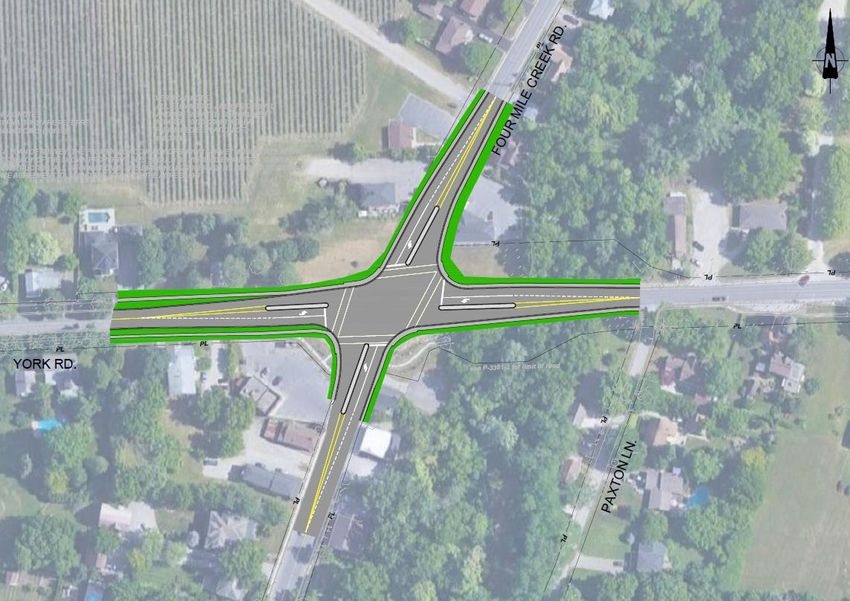
PIC #1 Summary Report – York Rd. and Four Mile Creek Rd. MCEA

Table of Contents
1   Introduction ............................................................................................................. 1
2   Project Team ........................................................................................................... 1
3   Notice of Public Information Centre #1 ................................................................. 1
4   Summary of PIC #1 ................................................................................................. 2
5   Summary of Comments and Responses .............................................................. 3
6   Conclusion .............................................................................................................. 7

List of Figures
Figure 1: Map Showing the EA Study Area and Consultation Area ................................. 2

List of Appendices
Appendix A: Notice of PIC #1
Appendix B: PIC #1 Presentation Slides
Appendix C: Comment Forms

           | B001271                                                                                                          ii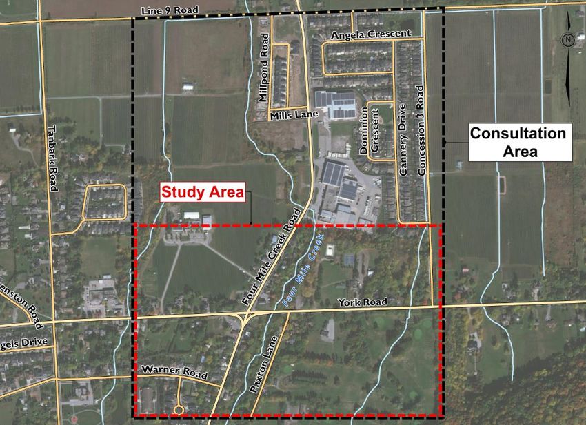
PIC #1 Summary Report – York Rd. and Four Mile Creek Rd. MCEA
1 Introduction
CIMA Canada Inc. (CIMA+) was retained by the Regional Municipality of Niagara
(Region) to conduct a Municipal Class Environmental Assessment (EA) Study for the
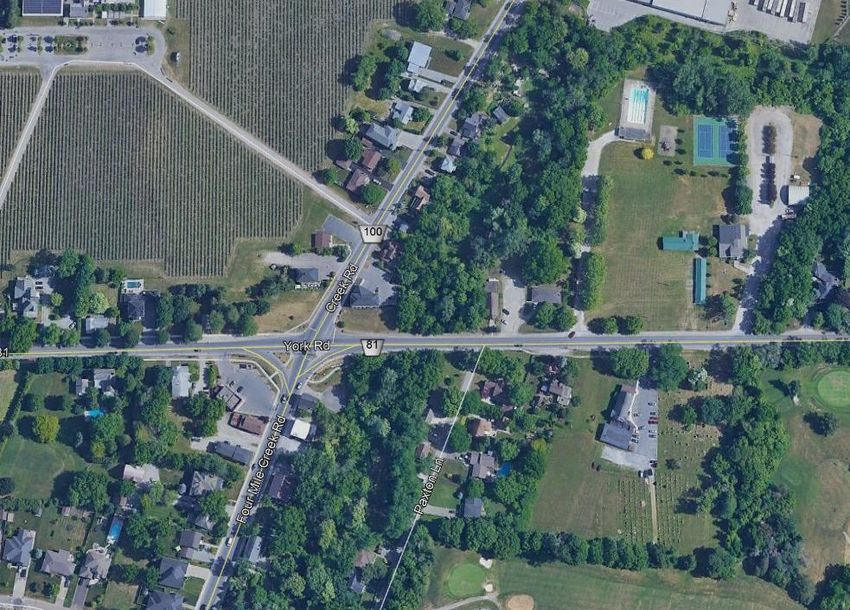
proposed intersection improvements at York Road (Regional Road 81) and Four Mile
Creek Road (Regional Road 100).
As part of this EA study, the project team held the first Virtual Public Information Centre
(PIC) on Thursday March 25, 2021. The purpose of this report is to summarize the PIC
and the comments received from the public and other stakeholders.
2 Project Team
The following key project members attended the PIC and assisted in answering some of
the inquiries:
Niagara Region:
• Maged Elmadhoon, Project Manager
• Sulaf Alkarawi, Associate Director of Transportation Systems and Planning
• Scott Fraser, Transportation Lead GO Implementation Office
Town of Niagara-on-the-Lake
• Mike Komljenovic, Supervisor of Engineering
CIMA+:
• Phil Weber, Project Manager
• Stephen Keen, EA Coordinator
3 Notice of Public Information Centre #1
A Notice of PIC #1 was prepared to inform the public, agencies, stakeholders, and
Indigenous Communities of the opportunity to review the project and provide input to the
project team. The Notice of PIC #1 outlined the purpose of the meeting and identified
the time, date, and format for the PIC. The Notice invited public comments on the study
by either attending the virtual PIC or contacting the project team via an online comment
form or email.
The Notice was posted on the project webpage on the Region’s website and advertised
in “Niagara This Week” and the “Niagara-on-the-Lake Local” for two consecutive weeks
on March 11, 2021 and March 18, 2021. The Notice was also emailed to agencies,
stakeholders, interested residents, Indigenous Communities and property owners within
| B001271 Page 1 of 7
PIC #1 Summary Report – York Rd. and Four Mile Creek Rd. MCEA

the Consultation Area as shown in Figure 1. A copy of the Notice is included in
Appendix A.

Figure 1: Map Showing the EA Study Area and Consultation Area

4       Summary of PIC #1
The PIC was held virtually on Zoom on Thursday March 25, 2021 from 6:00 PM to 8:00
PM. The format of the PIC was a live presentation provided, followed by a question-and-
answer session. A copy of the PIC presentation slides is provided in Appendix B, and a
summary of the key themes covered were:
    •   Welcome and Introduction
    •   Housekeeping Items
    •   Format and Purpose of PIC #1
    •   Introduction of the Key Project Team Members
    •   The Municipal Class EA Process
    •   The Consultation Process
    •   The Problem and Opportunity Statement
    •   Land Use and Environment

          | B001271                                                          Page 2 of 7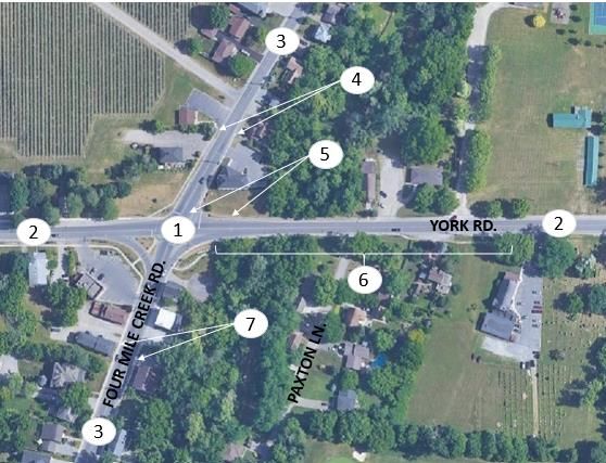
PIC #1 Summary Report – York Rd. and Four Mile Creek Rd. MCEA

    •   Existing Transportation
    •   Traffic Signal Concept
    •   Roundabout Concept
    •   Pedestrian and Cyclist Facilities at Roundabouts
    •   Pedestrian Experience at Intersections
           •   Pedestrian Safety at Roundabouts
           •   Pedestrian Security at Roundabouts
           •   Pedestrian Accessibility at Roundabouts
    •   Traffic Signals vs. Roundabouts
    •   Next Steps
    •   How You Can Get Involved
    •   Questions
Eighteen (18) people signed into the Zoom presentation. The PIC was recorded, and all
presentation materials were posted on the project webpage on the Region’s website.

5       Summary of Comments and Responses
All comments received from the presentation were noted and a comment form was
posted on the project webpage. Comment forms received by the project team are
provided in Appendix C.
The public was encouraged to provide input as this would be important in the evaluation
process for the alternatives. While comments were always welcomed from the project
team, comments specific to PIC #1 were requested to be submitted by April 8, 2021 to
allow the project team to review and respond accordingly.
The following provides a summary of the key comments and questions received during
the PIC process, and the project team responses.

          Comment / Question                        Project Team Response
 Traffic Operations / Road Safety

 Opportunity for potential bus routes in The team has reached out to the Region's
 the future.                             transportation division, and there are no
                                         current plans for expansion of mass transit to
                                         this area; however, transit is being
                                         considered as part of the design process.

 Concerns about traffic loading at the    Both alternatives under consideration, traffic
 intersection.                            signals and a roundabout, will be able to

          | B001271                                                             Page 3 of 7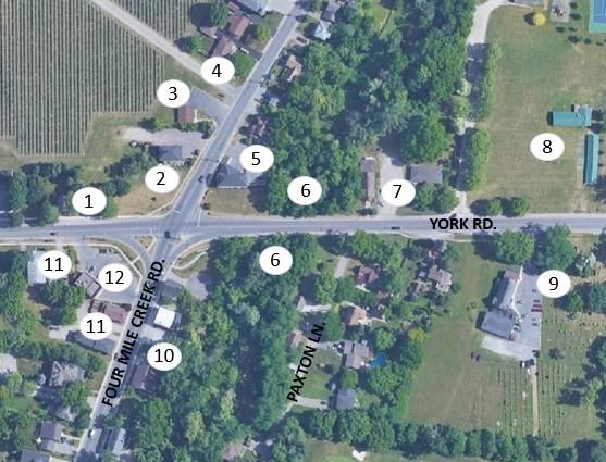
PIC #1 Summary Report – York Rd. and Four Mile Creek Rd. MCEA

        Comment / Question                         Project Team Response
                                         handle current and future traffic volumes at
                                         the intersection with no issues.

Concern regarding truck traffic from     Both York Road and Four Mile Creek Road
businesses in the area.                  are Regional Roads, so they must remain
                                         open to truck traffic.

Many concerns around speeding in         This has been noted by the project team and
the area                                 if the roundabout is the preferred alternative,
                                         it will help to slow traffic down in the vicinity
                                         of the intersection.
Concerns around drivers turning into     The project team will look into a right-turn
the St. Davids golf course and           lane to help avoid these types of collisions.
causing vehicle accidents.
Inquiries on potential widening of       There are currently no plans to widen York
York Road and / or Four Mile Creek       Road or Four Mile Creek Road.
Road.
Concerns regarding vehicles turning      Given the distance between Warner Road
off of Warner Road; will there be        and York Road (about 200 m), the availability
sufficient gaps in traffic to turn.      of gaps in the traffic stream on Four Mile
                                         Creek Road should not change with a
                                         change from all-way stop control to traffic
                                         signals or a roundabout.
Inquiries on how traffic data was        Traffic volumes were collected by automatic
collected.                               traffic recorders (the black rubber hoses left
                                         across the road for a few days), and through
                                         a turning movement count (where someone
                                         is physically at the intersection during the
                                         peak hours).
Interest in discouraging larger trucks   Both York Road and Four Mile Creek Road
from using this intersection.            are Regional Roads, so they must remain
                                         open to truck traffic.
Consideration for Fire Hall /            The project team has reached out to
emergency response times.                emergency services and will be sure to
                                         consider any impacts on response times. In
                                         other areas in Ontario, specifically Waterloo

        | B001271                                                                Page 4 of 7
PIC #1 Summary Report – York Rd. and Four Mile Creek Rd. MCEA

       Comment / Question                        Project Team Response
                                        Region which has a lot of roundabouts, there
                                        has been no issues of roundabouts
                                        impacting response times.
Concern around tourists using the       The project team will ensure that appropriate
roundabout.                             signage is in place to help tourists navigate
                                        the roundabout, should it be the preferred
                                        alternative.
Concern regarding the sightlines from Elimination of the existing channelized right-
Paxton Lane.                          turn lane at the Four Mile Creek Road
                                      intersection should help, as it should slow
                                      turning traffic. The team will also look into a
                                      right-turn lane into Paxton Lane.
Pedestrian Safety
Concern for pedestrian safety           The project team is aware of the pedestrian
especially children going to and from   traffic in the area and are ensuring
the elementary school west of the       pedestrian safety is a high priority of this
intersection and a discussion around    study. If a roundabout is the preferred
an education and awareness              alternative, the Region will ensure there is an
campaign for residents and              educational campaign for the residents in the
especially the elementary school.       area to ensure the safe use of a roundabout
Pedestrian traffic seems to be          for both pedestrians and drivers.
significant if this area.
Active Transportation
Length of potential new sidewalks;      Active transportation is a key feature of this
ensure connectivity to new              study and the project team is looking to
subdivision near Concession 3 Road.     improve the connectivity to the new
                                        subdivision.
Interest in Bike Lanes on York Road.    The project team is investigating this as part
                                        of the evaluation.
Consultation Area
Inquiries as to why the elementary      The Study Area is limited to the functional
school was not included within the      area of the intersection, approximately 250m
Study Area.                             in all directions except to the east where it

       | B001271                                                               Page 5 of 7
PIC #1 Summary Report – York Rd. and Four Mile Creek Rd. MCEA

        Comment / Question                        Project Team Response
                                        includes Concession 3 Road.

Inquiries regarding the Consultation    The Consultation Area was expanded north
Area extending north, but not south.    to account for the new developments that are
                                        currently underway and to ensure
                                        connectivity to these areas.
Aesthetics / History of Area
Interest in what the centre of the      The project team is discussing different
roundabout could include and            options that could be used if a roundabout is
potential landscaping options.          selected as the preferred alternative. Options
                                        include a garden, monument, plaque, etc.
Concerns around the two gardens at      The project team is aware of the gardens
the intersection – Pollinator Garden    and will consider the impacts as the design
on southeast corner and lavender        progresses.
garden in front of Avondale Food
Stores.
Concern over the impact of the          The project team has a subconsultant
historical sites present in the Study   undertaking an Archaeological and
Area.                                   Cultural/Built Heritage Assessment. The
                                        team has also contacted the Ministry to
                                        ensure all areas of historical significance are
                                        protected.
Construction Impacts
Impacts to businesses, residents and    The Region will ensure no driveways are
Churches during construction –          blocked during construction.
driveways being blocked etc.
Timeline of construction.               This is not known yet.
Cost of Project
Consideration for budget to fix tire    The project team will design the intersection
marks from large trucks turning and     to work for all vehicle types so this should not
leaving the roadway leaving marks in    be an issue.
the grass.

        | B001271                                                             Page 6 of 7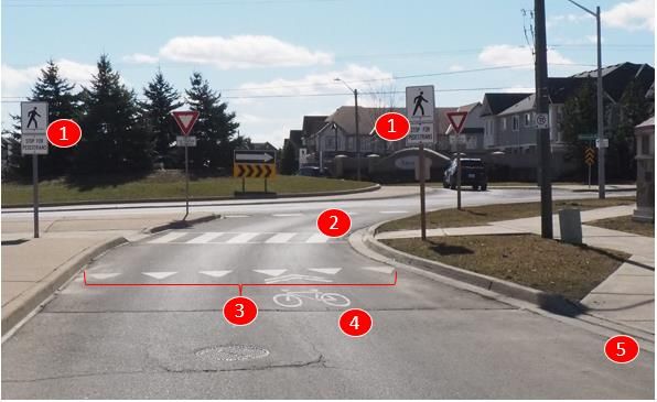
PIC #1 Summary Report – York Rd. and Four Mile Creek Rd. MCEA

         Comment / Question                         Project Team Response
 Clarification on whether the Town or     The Region will pay for the construction of
 the Region will be paying for the        new sidewalks; however, the Town will
 sidewalks in the area.                   maintain them once they are built.
 Other Comments
 Concern regarding the cemetery at        The project team is currently in the process
 the St. Davids Queenston United          of investigating this and will ensure that there
 Church and how the project could         are no impacts to any burial area.
 encroach on this property especially
 any sidewalks.
 Inquires regarding the amount and        If the roundabout is the preferred alternative,
 size of signage for the roundabout       appropriate signage will be a part of the
 option.                                  design to warn drivers. However, efforts will
                                          be made to limit the number and size of
                                          signs where possible (yet still maintain their
                                          effectiveness) out of respect for the area.
 Consideration for buying the             The project team has noted this and will
 overhead utility lines.                  investigate its feasibility.
 Inquiry regarding the culvert under      The project team is looking into this as the
 York Road and if it will need to be      design progresses.
 replaced.

6     Conclusion
The PIC was an opportunity to hear comments from the public on the existing
conditions, problems identified within the study area and alternative planning solutions.
All comments received will be reviewed by the project team and considered in the
selection of the preferred solution. A second PIC is planned for late spring 2021 to
present and receive feedback for the preliminary preferred alternative and associated
design concepts.

         | B001271                                                               Page 7 of 7
A Appendix A: Notice of PIC #1
Notice of Virtual Public Information Centre #1
Municipal Class Environmental Assessment for York
Road and Four Mile Creek Road Intersection
Improvements, St. Davids, Ontario
The Study
The intersection of Regional Road 81 (York Road) and Regional Road 100 (Four
Mile Creek Road) is located in the heart of the community of St. Davids in the Town
of Niagara-on-the-Lake. The intersection is currently controlled by an all-way stop,
and during peak periods motorists experience high delays. The skewed angle of the
intersection also creates vehicle safety issues, while there is an opportunity to
improve pedestrian and bicycle facilities for the intersection and vicinity. The study
area is shown below.

The Regional Municipality of Niagara is undertaking a Municipal Class Environmental
Assessment (EA) to address and improve conditions for all modes of transportation.
The MCEA schedule will be determined when the study team confirms the potential cost
of alternative implementation. This study will evaluate the need for additional
transportation capacity, improve street lighting and illumination, enhance transit and
active transportation through improved sidewalk connections and better pedestrian and
cyclist facilities, conform to a complete streets approach, and strengthen the area’s
relationship with its past.
You are invited to participate!
A key component of this study is public, agency, Indigenous, and stakeholder
consultation. Two (2) virtual Public Information Centres (PICs) will be held to present
the study findings and obtain public input.
The first PIC will be held in an online format. As part of this event, the Study Team will
deliver an online presentation followed by a Q&A on March 25, 2021 between 6:00 pm
and 8:00 pm to provide members of the public and stakeholders with an opportunity to
review the study background, existing conditions, problems and opportunities,
alternative solutions, and the next steps in the study.
Information about the Online Public Information Centre #1 will be available on the
project webpage starting March 25, 2021, and comments will be welcomed through
one of the project managers below, until April 8, 2021.
https://www.niagararegion.ca/projects/regional-road-100/default.aspx

Stay Connected!
If you would like to receive future notices via email, or if you have any questions or
comments, please contact one of the project managers identified below:

  Maged Elmadhoon, M.Eng., P.Eng.                       Phil Weber, M.Eng., P.Eng.
  Manager, Transportation Planning                      Senior Project Manager
  Regional Municipality of Niagara                      CIMA+
  1815 Sir Isaac Brock Way                              500 – 5935 Airport Rd.
  Thorold, ON L2V 4T7                                   Mississauga, ON L4V 1W5
  Phone: 905-980-6000, ext. 3583                        Phone: 905-695-1005, ext. 6732
  Maged.ElMadhoon@niagararegion.ca                      Phil.Weber@cima.ca

Under the Freedom of Information and Protection of Privacy Act and the Environmental
Assessment Act, unless otherwise stated in the submission, any personal information
such as name, address, telephone number and property location included in a
submission will become part of the public record files for this matter and may be
released, if requested, to any person.
This notice was first issued on March 11, 2021
B
Appendix B: PIC #1 Presentation Slides
WELCOME!
    Online Public Information
            Centre #1
York Road and Four Mile Creek Road Intersection Improvements
          Municipal Class Environmental Assessment
                       Thursday March 25, 2021
                 Live Presentation 6:00 PM – 8:00 PM
Housekeeping Items • When joining the online meeting, we request that you please turn off your microphone and camera • There will be an opportunity at the end of the presentation to ask any questions or submit comments • This presentation is being recorded and will be posted on the project webpage following this meeting • In case you would like to submit your feedback later, the presentation materials and an online Comment Form are available on the project webpage: https://www.niagararegion.ca/projects/regional-road-100/default.aspx
Public Information Centre #1
Format for PIC #1
• Project team introductions
• Presentation of PIC materials
• Question and answer session

Purpose of PIC #1
• To introduce the study to the
  public
• To present reasoning for the study,
  current conditions and alternative
  solutions
• To receive public input
Key Project Team

      Project Manager                     Project Manager
      Maged Elmadhoon                     Phil Weber

      Associate Director of
                                          Project Director/Lead EA Coordinator
      Transportation Systems & Planning
                                          Stephen Keen
      Sulaf Alkarawi
The Municipal Class EA Process
• A Municipal Class EA is a planning and design process approved by the Ministry of Environment,
Conservation and Parks (MECP) to meet the requirements of the Ontario Environmental
Assessment (EA) Act, which has the phases depicted in the figure below
• Either a Schedule ‘B’ or ‘C’ EA process will be selected once the impacts of the alternatives are
more clearly defined
Notice of Study
Commencement Notice of Study
January 2021 We are here PIC #2 Completion
Phase 1 Phase 2 Phase 3 Phase 4 Phase 5
• Identification • Alternative • Selection of • Environmental • Implementation
of Problem Solutions Preliminary Study Report of Preferred
and/or Identified Preferred (Schedule C) or Solution
Opportunity Solution & Project File
Alternative (Schedule B) –
Design 30-day
Concepts comment
periodThe Consultation Process • Notices were advertised in “Niagara This Week” and the “Niagara-on-the-Lake Local” on two consecutive weeks • Notices were also mailed to property owners within the consultation area depicted on the figure to the right • Notices were also emailed to all agencies, Indigenous Communities, special interest groups and interested persons • This Virtual PIC #1 is being hosted today to meet the requirements of the Municipal Class EA Process, and an additional PIC will be held at a later date to review the preferred solution and design concepts
Problem/Opportunity Statement
Problems                                          Opportunity
• The intersection currently experiences some     • Niagara Region is undertaking a Municipal
  peak hour capacity issues, which will             Class EA to identify an implementation
  increase as traffic volumes grow                  strategy for the transportation infrastructure
• The study area needs better pedestrian and        requirements for the subject intersection
  cyclist facilities                              • This study will evaluate the need for
• The location is listed under the Intersection     additional transportation capacity, improve
  Improvement Program in the Region’s               street lighting and illumination, enhance
  Transportation Master Plan (TMP)                  transit and active transportation through
                                                    improved sidewalk connections and better
                                                    pedestrian and cyclist facilities, conform to a
                                                    complete streets approach, and strengthen
                                                    the area’s relationship with its past
Land Use and Environment Old barn The Old Firehall restaurant Canada Post Ravine Vineyard Estate Winery St Davids Dental Four Mile Creek First Presbyterian Church St Davids Lions Park St Davids Queenston United Church Bloom & Co./Niagara-on-the-Lake Realty Vineyard Square development Avondale Food Stores
Existing
Transportation
Intersection is an all-way stop
20 m ROW and 50 km/h speed limit on
York Rd.
Narrow 16 m ROW and 50 km/h speed
limit on Four Mile Creek Rd.
Sidewalks transition to asphalt shoulders
65 m north of intersection
No crosswalk on north leg of intersection,
and no sidewalk on north side of York Rd.
Sidewalk on south side of York Rd. only,
east of intersection to United Church
Sidewalks are narrow and close to road
south of intersection
Traffic Signal
Concept
• Add traffic signals, left-
  turn lanes and medians
  on all approaches
• Eliminate channelized
  right-turn lanes on
  southeast and southwest
  corners
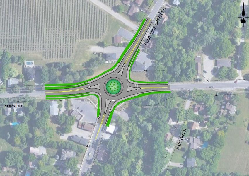
Roundabout
Concept
• Install a roundabout with
  single-lane entries and
  exits
• Diameter would be about
  40 m, smaller than the
  roundabout on Niagara
  Stone Rd. and Concession
  6 Rd.
Pedestrian/Cyclist Facilities at a Roundabout
Regulatory crosswalk signs (may
be supplemented with pedestrian-
actuated rapid flashing beacons
overtop)
Zebra crosswalk markings
Yield-to-pedestrian line (indicates
where drivers are to stop for
pedestrians, and cyclists walking
their bikes)
Share the lane with cyclists or
“sharrow” marking
Ramp to sidewalk, so that cyclists
who don’t want to ride through
the roundabout can walk around
the outside using the sidewalks
and crosswalks
Pedestrian Experience at Intersections
• There are four components of the pedestrian experience at intersections

     Statistical Level   Feeling of Safety      Level of          Convenience
        of Safety           (Security)        Accessibility
Pedestrian Safety at Roundabouts
• Statistically, roundabouts (especially single-lane) are safer
for pedestrians than traffic signals
• This is because
• Traffic speeds are lower, giving pedestrians and drivers more
time to judge gaps and react to each other
• The crossing distance is less
• Pedestrians need only watch for traffic in one direction at a time
• Drivers are more likely to be looking in the direction of
pedestrians, instead of up at signals or left while turning rightPedestrian Security at Traffic Signals • However, pedestrians often feel safer at intersections with traffic signals because of the pedestrian signals • This feeling of safety (security) happens when the signals tell them it’s “safe” to cross • Most crashes involving pedestrians occur when drivers turn left or right across the crosswalk while the pedestrian has a Walk indication
Pedestrian Accessibility at Roundabouts
• Not everyone is comfortable finding or creating a gap
  in traffic in order to cross at a roundabout
   • Seniors can find this difficult
   • Children may not have the experience or confidence
• Pedestrians with vision loss can find roundabouts
  even more difficult to navigate
• Roundabouts can be made more accessible by
  ensuring they have tactile walking surface indicators
  and, if necessary, by installing rapid flashing beacons
  overtop the crosswalk signs
Traffic Signals vs. Roundabouts
Typical advantages of signals over               Typical advantages of roundabouts
roundabouts                                      over signals
• Lower construction costs                       • Lower life cycle costs
• Requires less property at an intersection      • More efficient for motorists (especially during
• May be perceived to be safer for pedestrians     off-peak hours)
  and cyclists (security)                        • Lower traffic speeds
• More accessible to persons with vision loss    • Lower vehicle noise, fuel consumption and
                                                   emissions
                                                 • Statistically safer for motorists and pedestrians
                                                 • Provides streetscaping opportunities
Next Steps • Review comments received from this PIC • Complete technical studies (environmental impact study, Cultural Heritage Report, Archaeological Report) • Select a preliminary preferred alternative • Develop design concepts for the preliminary preferred concept • Continue to meet with Stakeholders and Agencies • Present the preliminary preferred solution and the design concepts at PIC #2 in late spring 2021
How You Can Get Involved
• Ask questions or discuss issues with the Project Team following this presentation
• Request to be added to the project contact list to receive future project Notices
• Attend PIC #2 – late spring 2021
• Please submit any comments using a Comment Form available on the project
  webpage by April 8, 2021
• Visit the project webpage for more information:
  https://www.niagararegion.ca/projects/regional-road-100/default.aspx
Questions?

  Maged Elmadhoon, M.Eng., P.Eng.    Phil Weber, M.Eng., P.Eng.
  Manager, Transportation Planning   Senior Project Manager
  Regional Municipality of Niagara   CIMA+
  Phone: 905-980-6000, ext. 3583     Phone: 905-695-1005, ext. 6732
  Maged.ElMadhoon@niagararegion.ca   Phil.Weber@cima.ca
C
Appendix C: Comment Forms
Municipal Class Environmental Assessment for York Road and Four Mile Creek Road
                   Intersection Improvements, St. Davids, Ontario

                   Public Information Centre #1 - Thursday March 25, 2021

                                          COMMENT SHEET
COMMENTS
My preference is for a mini-roundabout.
I think that considerable public education will be required to fully ensure proper usage of the roundabout.
This will be necessary for both motorists and pedistrians/cyclists

Has a survey been undertaken regarding pedestrian usage? From a general observation
pedestrian usage from the Avondale area to the Canada Post Office seems significant.

Please return completed comment sheet to one of the Project Managers below by April 8th, 2021

Maged Elmadhoon, M.Eng., P.Eng.                         Phil Weber, M.Eng., P.Eng.
Manager, Transportation Planning                        Senior Project Manager
Regional Municipality of Niagara                        CIMA+
Phone: 905-980-6000, ext. 3583                          Phone: 905-695-1005, ext. 6732
Maged.ElMadhoon@niagararegion.ca                        Phil.Weber@cima.ca

PLEASE PRINT CLEARLY
Name:  Redacted for Privacy

Address:
 Email:                                                               Postal Code:
Municipal Class Environmental Assessment for York Road and Four Mile Creek Road
Intersection Improvements, St. Davids, Ontario
Public Information Centre #1 - Thursday March 25, 2021
COMMENT SHEET
COMMENTS
1. Will the 4 mile creetk culvert under York Road have to be replaced?? has been
in place since the 50's
2. Sight lines from Paxton Lane to the corner should be a serious concern
have witnested many near misses turning left from the lane onto York
due to high speed exiting the corner traveling east
3. What are the plans for 2 major historical sites
Please return completed comment sheet to one of the Project Managers below by April 8th, 2021
Maged Elmadhoon, M.Eng., P.Eng. Phil Weber, M.Eng., P.Eng.
Manager, Transportation Planning Senior Project Manager
Regional Municipality of Niagara CIMA+
Phone: 905-980-6000, ext. 3583 Phone: 905-695-1005, ext. 6732
Maged.ElMadhoon@niagararegion.ca Phil.Weber@cima.ca
PLEASE PRINT CLEARLY
Name: Redacted for privacy
Address:
Email: Postal Code:You can also read