Revised Technical Implementation Plan for the ShakeAlert System-An Earthquake Early Warning System for the West Coast of the United States
←
→
Page content transcription
If your browser does not render page correctly, please read the page content below
Revised Technical Implementation Plan for the ShakeAlert
System—An Earthquake Early Warning System for the
West Coast of the United States

Open-File Report 2018–1155
Supersedes USGS Open-File Report 2014–1097

U.S. Department of the Interior
U.S. Geological Survey
Cover images: Photographs showing potential beneficiaries of ShakeAlert, the earthquake early warning system for the West Coast of the United
States. Clockwise from the upper left: ShakeAlert may provide enough warning (top left) to slow or stop taxiing planes (photograph from Ersin Ergin/
Shutterstock.com), (top middle) for surgeons or other medical professionals to stop delicate procedures (photograph from Andrei_R./Shutterstock.
com), and (top right) for water companies to close valves and preserve precious water reserves (photograph from cpaulfell/Shutterstock.com). In
addition, ShakeAlert may provide enough warning for (bottom left) people to drop, cover, and hold on (photograph from ChameleonsEye/Shutterstock.
com); (bottom middle) first responders to open bay doors in advance of the shaking (photograph from Seattle Fire Department); and (bottom right) train
operators to slow or stop trains (photograph from James Kirkikus/Shutterstock.com).
Revised Technical Implementation Plan for
the ShakeAlert System—An Earthquake
Early Warning System for the West Coast of
the United States

By Douglas D. Given, Richard M. Allen, Annemarie S. Baltay, Paul Bodin,
Elizabeth S. Cochran, Kenneth Creager, Robert M. de Groot, Lind S. Gee, Egill
Hauksson, Thomas H. Heaton, Margaret Hellweg, Jessica R. Murray, Valerie I.
Thomas, Douglas Toomey, and Thomas S. Yelin

Open-File Report 2018–1155
Supersedes USGS Open-File Report 2014–1097

U.S. Department of the Interior
U.S. Geological Survey
U.S. Department of the Interior
RYAN K. ZINKE, Secretary

U.S. Geological Survey
James F. Reilly II, Director

U.S. Geological Survey, Reston, Virginia: 2018
Supersedes USGS Open-File Report 2014–1097

For more information on the USGS—the Federal source for science about the Earth, its natural and living
resources, natural hazards, and the environment—visit https://www.usgs.gov or call 1–888–ASK–USGS
(1–888–275–8747)..
For an overview of USGS information products, including maps, imagery, and publications,
visit https://store.usgs.gov.

Any use of trade, firm, or product names is for descriptive purposes only and does not imply endorsement by the
U.S. Government.

Although this information product, for the most part, is in the public domain, it also may contain copyrighted materials
as noted in the text. Permission to reproduce copyrighted items must be secured from the copyright owner.

Suggested citation:
Given, D.D., Allen, R.M., Baltay, A.S., Bodin, P., Cochran, E.S., Creager, K., de Groot, R.M., Gee, L.S., Hauksson, E.,
Heaton, T.H., Hellweg, M., Murray, J.R., Thomas, V.I., Toomey, D., and Yelin, T.S., 2018, Revised technical
implementation plan for the ShakeAlert system—An earthquake early warning system for the West Coast of the
United States: U.S. Geological Survey Open-File Report 2018–1155, 42 p., https://doi.org/10.3133/ofr20181155.
[Supersedes USGS Open-File Report 2014–1097.]
ISSN 2331-1258 (online)
iii

Contents
Executive Summary........................................................................................................................................1
Introduction.....................................................................................................................................................2
Vision.................................................................................................................................................................3
Mission.............................................................................................................................................................3
Goal............................................................................................................................................................ 3
Authorities........................................................................................................................................................3
The Physics of the Problem..........................................................................................................................3
Benefits and Uses of ShakeAlert.................................................................................................................5
A Brief History of Early Earthquake Warning.............................................................................................6
The ShakeAlert System Strategy.................................................................................................................7
     Evolutionary Implementation...............................................................................................................7
     Other Partnerships and Collaboration................................................................................................7
     Phased Rollout Strategy.......................................................................................................................7
Major System Components...........................................................................................................................7
     Sensor Networks...................................................................................................................................8
              Seismic Stations...........................................................................................................................8
              Global Navigation Satellite System Stations..........................................................................10
                       Required Station Distribution...........................................................................................11
                       Contributing GNSS Networks..........................................................................................13
                       Goals for GNSS Network Upgrades...............................................................................13
                       GNSS Network Upgrades in California..........................................................................14
                       GNSS Network Upgrades in Oregon and Washington................................................14
     Field Telemetry.....................................................................................................................................14
     Processing and Alert Centers............................................................................................................14
     System Architecture and Scientific Algorithms.............................................................................15
              Geodetic Algorithms...................................................................................................................16
     Testing and Certification.....................................................................................................................16
     System Operation, Code Deployment, and Monitoring.................................................................17
     ShakeAlert Products...........................................................................................................................17
              Message Types...........................................................................................................................18
              Alert Release Thresholds..........................................................................................................20
              Performance Metrics and Standards......................................................................................22
Alert Distribution and Use...........................................................................................................................22
     Alerts to Institutional Users—Pilot Projects...................................................................................22
Alerts to the Public.......................................................................................................................................23
     Mass Alerting via FEMA’s Integrated Public Alert and Warning System and Cellular
                   Networks.................................................................................................................................23
     Push Notifications to Cell Phones.....................................................................................................24
     Social Media.........................................................................................................................................25
     Mass Notification Companies...........................................................................................................25
     Digital Radio Broadcasts....................................................................................................................25
     Other Alert Delivery Technologies....................................................................................................25
Communications, Education, and Outreach.............................................................................................26
ShakeAlert Partners and Users..................................................................................................................26
iv
Direct Institutional Users....................................................................................................................27
Commercial Partners..........................................................................................................................27
System Roles and Governance..................................................................................................................27
State Partners......................................................................................................................................28
Expanding to Other Regions........................................................................................................................28
Continuing Research and Development...................................................................................................29
Budget Estimate............................................................................................................................................30
Capital Infrastructure Budget............................................................................................................30
Operations and Maintenance Budget..............................................................................................31
Timeline...........................................................................................................................................................32
Conclusion.....................................................................................................................................................32
References.....................................................................................................................................................33
Appendix 1. ShakeAlert Primary Messages.............................................................................................37
Appendix 2. ShakeAlert Reporting Region...............................................................................................39
Appendix 3. List of Current ShakeAlert Pilot Users and Technology Partners...................................40
Appendix 4. Funding History.......................................................................................................................41
Appendix 5. Telemetry Improvement Plan................................................................................................42
Figures
1. Schematic cross section of the Cascadia Subduction Zone showing the three
categories of earthquakes for which the ShakeAlert system must generate alerts.............4
2. Map of the western United States showing current and proposed locations of seismic
stations needed for ShakeAlert as of March 2018........................................................................9
3. Schematic drawing of a typical seismic station used by the ShakeAlert system................10
4. Map of existing Global Navigation Satellite System stations in the geographic region
of interest in California......................................................................................................................11
5. Map of existing Global Navigation Satellite System stations in the geographic region
of interest in Washington and Oregon...........................................................................................12
6. Schematic flowchart showing the architecture of the ShakeAlert system version 2.0......16
7. Screen shot image of the DMreview tool.....................................................................................18
8. Two maps of the western United States showing examples of the shaking intensity
contour and grid map ground-motion products distributed by ShakeAlert...........................19
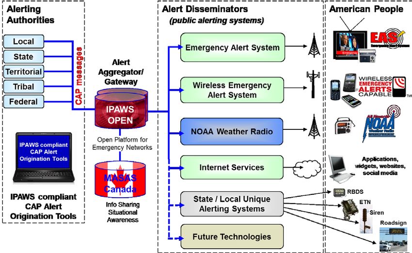
9. Schematic drawing showing the architecture of the Federal Emergency Management
Agency’s Integrated Public Alert and Warning System.............................................................23
Appendix Figure
2.1. Map of the ShakeAlert reporting region and Advanced National Seismic System
regional network reporting areas in the western United States and Canada.......................39
v

Tables
          1. Status of ShakeAlert seismic stations as of April 2018..............................................................10
          2. Summary of estimated capital and operation and maintenance budgets to complete
             and operate the ShakeAlert system...............................................................................................31
          3. Summary of capital costs to complete buildout of ShakeAlert infrastructure by
             Advanced National Seismic System region.................................................................................31
          4. Summary of annual operations and maintenance budget for the ShakeAlert system
             by Advanced National Seismic System region............................................................................31

Appendix Tables
    2.1.       Vertices that define the ShakeAlert reporting region.................................................................39
    4.1.       Historical Federal funding for the ShakeAlert system................................................................41
    4.2.       Historical Non-Federal funding for the ShakeAlert system.......................................................41
    5.1.       Summary of capital and operation and maintenance budget estimates to complete the
               three-state telemetry improvement plan for the ShakeAlert system by Advanced National
               Seismic System region.......................................................................................................................42

Key Terms, Abbreviations, and Symbols
ActiveMQ                     An open-source enterprise message broker service used to communicate
                             between ShakeAlert modules and data centers
AMBER		                      America’s Missing: Broadcast Emergency Response
ANSS			                      Advanced National Seismic System
APTS			                      America’s Public Television Stations
AQMS			                      ANSS Quake Monitoring System
ATIS			                      Alliance for Telecommunications Industry Solutions
BARD			                      UC Berkeley’s Bay Area Regional Deformation network
BART			                      Bay Area Rapid Transit
Cal OES		                    California Governor’s Office of Emergency Services
Caltech		                    California Institute of Technology
CGS			                       California Geological Survey
CISN			                      California Integrated Seismic Network
ComCat		                     ANSS Comprehensive Earthquake Catalog
CREW			                      Cascadia Region Earthquake Workgroup
CWU			                       Central Washington University
datalogger                   Field-hardened computer that accepts signals from a sensor, transforms them
                             into digital data, and transmits them over a telemetry system to central
                             processing sites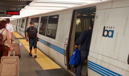
vi

     EAS			       Emergency Alert System
     ECA			       Earthquake Country Alliance
     EEW			       earthquake early warning
     EPIC			      Earthquake Point-source Integrated Code; ShakeAlert’s earthquake
                  point-source solution algorithm
     ESA			       Endangered Species Act
     ETH Zurich   Swiss Federal Institute of Technology in Zurich
     eWEA			      Enhanced Wireless Emergency Alerts
     FCC			       Federal Communications Commission
     FEMA			      Federal Emergency Management Agency
     FinDer			    Finite-fault detector algorithm; ShakeAlert’s seismic line-source solution
                  algorithm
     GLONASS      Global Orbiting Navigation Satellite System (Russian)
     GNSS			      Global Navigation Satellite System; composed of national systems including
                  GPS (United States), GLONASS (Russian), Galileo (European Union), BeiDou
                  (Chinese), and others
     GPS			       Global Positioning System
     IPAWS		      Integrated Public Alert and Warning System
     IPAWS-OPEN   IPAWS Open Platform for Emergency Networks
     IRIS			      Incorporated Research Institutions for Seismology
     IT			        information technology
     JCCEO		      Joint Committee for Communication, Education, and Outreach
     km			        kilometers
     latency		    Any delay in the processing chain from the time the earthquake begins until
                  end users receive data or alerts
     LTE			       long-term evolution
     M			         earthquake magnitude
     MMI          Modified Mercalli Intensity
     NEHRP		      National Earthquake Hazards Reduction Program
     NEPA			      National Environmental Policy Act
     NHPA			      National Historic Preservation Act
     NIST			      National Institute of Standards and Technology
vii

NOAA			           National Oceanic and Atmospheric Administration
NSF			            National Science Foundation
PANGA		           CWU’s Pacific Northwest Geodetic Array
PBO			            Plate Boundary Observatory
PGA			            peak ground acceleration
PGV			            peak ground velocity
PNSN			           Pacific Northwest Seismic Network
P-wave            Primary wave; the faster moving compressional wave that arrives first during
                  an earthquake
SCEC			           Southern California Earthquake Center
sensor		          An instrument that measures ground motions
seismic station   A location with an installed datalogger, power system, telemetry, and sensors
                  that measures ground motions and transmits them to data processing centers
SESAC		           Scientific Earthquake Studies Advisory Committee (for the USGS Earthquake
                  Hazards Program)
SI			             shindo seismic intensity scale (Japanese)
SSL			            secure sockets layer
S-wave            Secondary wave; the slower moving shear wave that arrives after the P-wave
                  during an earthquake
telemetry         Telecommunication capability that carries ground-motion data from sensor
                  stations in the field to central processing sites
UC Berkeley       University of California, Berkeley
UNR			            University of Nevada, Reno
URL			            Uniform Resource Locator (a “web address”)
USGS			           U.S. Geological Survey
USGS EHP          U.S. Geological Survey’s Earthquake Hazards Program\
UW			             University of Washington
VoIP			           Voice over Internet Protocol
WEA			            Wireless Emergency Alerts; uses cellular broadcast technology in
                  commercial cell systems to send mass alerts to the public
XML			            extensible markup language
Revised Technical Implementation Plan for the ShakeAlert
System—An Earthquake Early Warning System for the
West Coast of the United States
By Douglas D. Given1, Richard M. Allen2, Annemarie S. Baltay1, Paul Bodin3, Elizabeth S. Cochran1, Kenneth
Creager3, Robert M. de Groot1, Lind S. Gee1, Egill Hauksson4, Thomas H. Heaton4, Margaret Hellweg2, Jessica
R. Murray1, Valerie I. Thomas1, Douglas Toomey5, and Thomas S. Yelin1

Executive Summary                                                            This implementation plan calls for a total of 1,675 high-
                                                                       quality, real-time EEW-capable ANSS seismic stations—1,115 in
      The U.S. Geological Survey (USGS), along with partner            California and 560 in the Pacific Northwest. These seismic station
organizations, has developed an earthquake early warning (EEW)         numbers are based on a station spacing of 10 kilometers (km) in
system called ShakeAlert for the highest risk areas of the United      urban areas, 20 km in seismic source areas that endanger popula-
States: namely, California, Oregon, and Washington. The purpose        tion centers, and 40 km in other areas. About 865 seismic stations
of the system is to reduce the impact of earthquakes and save lives    are currently contributing data to ShakeAlert and 250 more have
and property by providing alerts that are transmitted to the public    funding and are currently being built. This plan would complete
via mass notification technologies and more detailed data streams      the buildout by upgrading or adding 560 seismic stations: 283 in
to institutional users and commercial service providers to trigger     California and 277 in Oregon and Washington. This budget also
automated user-specific protective actions.                            includes the one-time capital cost to make geodetic networks in
      When an earthquake occurs, seismic waves radiate from            California and the Pacific Northwest EEW-capable by upgrading
the rupturing fault like waves on a pond. It is these waves people     about 475 Global Navigation Satellite System (GNSS) geodetic
feel as earthquake shaking and which cause damage to structures.       stations in USGS and cooperator networks with modern GNSS
Using networks of ground-motion sensors and sophisticated              receivers that incorporate clock corrections for onboard position-
computer algorithms, ShakeAlert can detect an earthquake               ing and improving telemetry where needed.
seconds after it begins, calculate its location and magnitude, and           ShakeAlert’s mission requires fast, reliable telemetry to
estimate the resulting intensity of shaking. Alerts, including early   deliver sensor data to processing centers. The ANSS networks cur-
warnings of impending shaking, can then be sent to people and          rently use both commercial and their own specialized telecommu-
systems that may experience damaging shaking, allowing them            nication infrastructure. The networks also have collaborators that
to take appropriate protective actions. Depending on the user’s        provide telemetry bandwidth, thereby reducing costs. However,
distance from the earthquake, alerts may be delivered before,          existing data pathways can be fragile so this document includes
during, or after the arrival of strong shaking. The ShakeAlert         estimates for telemetry infrastructure upgrades designed to survive
system can update its ground-motion estimates as an earthquake         strong ground shaking and the heavy telecommunications conges-
grows larger.                                                          tion that will come with a large earthquake.
      ShakeAlert is built on the foundation of the sensor                    The ShakeAlert data processing infrastructure includes
networks and data processing infrastructure of the USGS-led            redundant servers that are geographically distributed at the
Advanced National Seismic System (ANSS). However, these                monitoring centers of tier 1 ANSS seismic networks in Seattle,
networks were not originally designed for EEW; old equip-              Washington, as well as Menlo Park, Berkeley, and Pasadena in
ment needs to be updated and new stations need to be added to          California. There are three data processing layers. The data layer
construct EEW-capable networks.                                        handles raw ground-motion data from field stations and is part of
                                                                       the routine ANSS Quake Management System (AQMS) operated
                                                                       by the ANSS networks. The production layer analyzes these data
  1
   U.S. Geological Survey.
                                                                       using ShakeAlert algorithms to detect earthquakes, calculate their
                                                                       locations and magnitudes, and estimate the area and intensity of
  2
   University of California, Berkeley.
                                                                       the resulting shaking. The alert layer checks these geophysical
  3
   University of Washington.                                           solutions against alert release criteria and creates and publishes
  4
   California Institute of Technology.                                 alert products as appropriate. Users connect to alert layer servers
  5
   University of Oregon.                                               to subscribe to alert and data streams.
2 Revised Technical Implementation Plan for the ShakeAlert System
ShakeAlert currently has two independent algorithms to improvement plan. Building a highly reliable data telemetry
detect and characterize earthquakes using seismic data. The first is infrastructure would cost another $20.5 million; however, this
EPIC (earthquake point-source integrated code), which produces cost could be reduced if project partners provide bandwidth on
point-source solutions. EPIC measures several ground-motion existing systems. Operating this highly reliable data telemetry
parameters in small time windows and associates them to locate would add another $9.8 million per year of costs; but this also
the earthquakes and estimate magnitudes. EPIC employs multiple could be reduced by partners providing bandwidth at low or no
checks to discriminate between random noise and earthquake cost to the project.
shaking, including a “filter bank” check to reject large remote
earthquakes, called teleseisms. The second algorithm is FinDer
(finite-fault detector), which can produce either a point-source Introduction
or, for larger earthquakes, a line-source solution. It estimates the
fault’s centroid location, orientation, and length using a pattern Earthquakes are a national problem, with more than
search technique to fit ground-motion observations to precalcu- 143 million people exposed to potentially damaging shaking in
lated fault templates. EPIC and FinDer algorithms both update fre- the United States (Jaiswal and others, 2015). Most of our nation’s
quently as the earthquake grows and more data become available. earthquake risk is concentrated in the highly populated areas
Algorithms to utilize geodetic data are currently in development on the active plate tectonic boundary of the West Coast of the
and will be added to ShakeAlert in the future. continental United States. The Federal Emergency Management
ShakeAlert publishes several data and alert products to Agency (FEMA) has estimated that the annualized loss from
meet the needs of different users. All messages include the earthquakes nationwide is $6.1 billion per year, with 73 percent
location of the earthquake, either as a point or a line, and its of that figure ($4.5 billion per year) coming from California,
magnitude. Ground-shaking estimates are published in two Oregon, and Washington and 61 percent ($3.7 billion per year)
forms, ground-motion contours or a map grid. Alert products from California alone (Federal Emergency Management Agency,
are released to institutional users for events of magnitude 3.5 2017). This estimate is only for building-related losses, and does
or greater. A lower threshold would result in more false alerts. not include components such as utility and transportation losses,
The threshold for initial public alerting will be magnitude 5.0 business interruption, and the losses associated with deaths and
or greater, but this alert threshold could be lowered as the injuries. In the next 30 years, California has a 99.7 percent chance
system improves and public confidence in and familiarity with of a magnitude 6.7 or larger earthquake (Field and others, 2015)
ShakeAlert increases. and the Pacific Northwest has a 10 percent chance of a magnitude
To have the greatest benefit, EEW alerts, or “ShakeAlerts,” 8 to 9 megathrust earthquake on the Cascadia Subduction Zone
will be delivered to institutional users and individuals by all (Field and others, 2008).
practical pathways. The USGS alert layer can support thousands of An earthquake early warning (EEW) system detects
institutional users and alert redistributors, but the USGS does not earthquakes so quickly that an alert can reach some areas before
have the mission nor the infrastructure and expertise to perform strong shaking arrives so that protective actions can be taken.
mass notifications to the public. Although our strategy is to use The earthquake’s location and magnitude are rapidly estimated
existing Federal and private mass alerting systems, these message by measuring the first shaking with sensors near the source. The
delivery technologies must be upgraded to be fast enough for ground-shaking intensity expected across the affected region
effective EEW. Also, it is beyond the mission and abilities of the is then estimated and alerts sent to people or systems in those
USGS to implement automatic actions for end users. To meet this areas, in some cases before the larger, more damaging shaking
need, we are recruiting private sector “technology enablers” that arrives. As the earthquake grows, more data become available
have the necessary expertise to develop end-user implementations from additional sensors and the system revises these ground-
with the goal of stimulating an EEW industry. motion estimates and updates its alerts. The area very close to
EEW alerts are useless if people do not know how to respond the epicenter may not receive the alert before strong shaking
to them. Although the alert messages will include instructions begins but can still benefit from the information that a significant
about what to do (drop, cover, and hold on), alerts will be more earthquake is occurring. The size of this area can be minimized
effective if people have been trained in advance. Messages about by having dense networks with sensors close to the epicenter, fast
ShakeAlert’s capabilities, limitations, and benefits should be detection algorithms and alerting software, and rapid alert-delivery
integrated with existing earthquake education programs, including technologies. More distant locations will have more time to act but
State-run programs. Therefore, ShakeAlert will coordinate with will typically experience less intense shaking.
both public and private partners and stakeholders through various In 2006, the U.S. Geological Survey (USGS) began funding
partnerships and agreements to accomplish consistent and ongoing the development of EEW in collaboration with university,
public education. State, and private partners and has the goal of building a public
The estimated cost of completing the computing infra- system for three States of the West Coast of the United States:
structure and sensor networks for ShakeAlert is $39.4 million. California, Oregon, and Washington. Built on three of the eleven
The annual operation and maintenance cost of the completed regional seismic networks of the Advanced National Seismic
system is estimated to be $28.6 million per year. This docu- System (ANSS), those efforts resulted in a demonstration system
ment also provides estimates of the added costs for a telemetry called ShakeAlert, which began sending test notifications toThe Physics of the Problem 3
select users in January 2012. In February 2016, the ShakeAlert
Production Prototype version 1.0 went live in California and
Authorities
began providing notifications to a small group of early pilot The USGS was established by the Organic Act of
users. In April 2017, Production Prototype version 1.2 went live March 3, 1879 (20 Stat. 394, 43 U.S.C. 31 et seq.). The
for some areas of the entire West Coast. In this phase, alerts were Earthquake Hazards Reduction Act (P.L. 95–124) gives the
not sent to the general public, but pilot users were encouraged USGS the Federal responsibility for providing notifications
to develop and deploy functioning implementations to take of earthquakes. The USGS is tasked with developing an
automatic actions to protect their infrastructure and alert their EEW system in the United States in the Earthquake Hazards
employees. At the same time, commercial technology enablers Reduction Act of 1977 (42 U.S.C. 7701 et seq.). Also,
began developing products to protect infrastructure and alert the most recent National Earthquake Hazards Reduction
people. In 2016, the USGS announced its goal of rolling out the Program (NEHRP) authorization (P.L. 108–360) notes the
first phase of public alerting in 2018. loss-reduction value of early warning systems (sec. 7701),
specifically calls for disseminating warnings of earthquakes
(sec. 7702), and authorizes the USGS to establish and operate
Vision the ANSS “in order to enhance earthquake research and
warning capabilities” (sec. 7707). FEMA has granted the
The vision of the USGS is to reduce the impact of earth- USGS the authority to alert the public through its Integrated
quakes and save lives and property in the United States by Public Alert and Warning System (IPAWS).
developing and operating a public earthquake early warning
capability for high-risk regions.
The Physics of the Problem
Mission The ShakeAlert system must generate alerts for different
types of potentially damaging earthquakes. Earthquakes
The USGS, along with partner organizations, will develop on the West Coast of the United States fall into three broad
and operate an EEW system, called ShakeAlert, for the highest categories—shallow crustal, plate interface, and intraslab events
risk areas of the United States. The ShakeAlert system will (fig. 1). Shallow crustal earthquakes are the most frequent and
leverage the current earthquake-monitoring capabilities of the occur all along the West Coast. These events occur on faults
ANSS (U.S. Geological Survey, 2017) and provide alerts free of in the cooler brittle zone of the Earth’s crust from the surface
charge to the public via all practical emergency-alert channels. down to a depth of about 35 kilometers (km) (20 miles). Such
ShakeAlert will also provide more information-rich alert streams earthquakes can reach magnitudes (M) as high as 8.0. Well-
to specialized users, including commercial service providers, for known faults that produce large shallow crustal earthquakes
use in user-specific applications. The USGS will promote and help include the San Andreas, Hayward, and Seattle Faults.
coordinate public education about the ShakeAlert system and its The Cascadia Subduction Zone produces two additional
capabilities, limitations, and benefits to users. This mission will be types of earthquakes. Plate interface events occur where the
accomplished in cooperation with both public and private partners oceanic plate is thrust under the overriding continental plate in
and stakeholders through various partnerships and agreements. a process known as subduction. A sudden slip at the interface
between the two plates can generate megathrust earthquakes
as large as M9.0 or larger. Such an event occurred off the coast
of the Pacific Northwest in 1700 and produced a large tsunami
Goal that caused damage as far away as Japan. In contrast, intraslab
events occur within the down-going oceanic plate as it bends
The goal of the USGS and partners is to build and operate and breaks underneath the continent. As a result, these events
the ShakeAlert system in three States of the West Coast of the are deep and typically produce less ground shaking than
United States—California, Oregon, and Washington. The USGS interface or crustal events of comparable magnitude. However,
will generate alerts of potentially damaging earthquakes (called intraslab events can still cause damage when they are located
ShakeAlerts) that will be served to the public, and will send rapid under population centers, such as Portland, Oregon, or Seattle,
earthquake and ground-motion data to Government agencies and Washington. The 2001 M6.8 Nisqually earthquake that
private users on a region-by-region basis as soon as the ShakeAlert damaged Seattle was an intraslab earthquake.
system, its products, and its parametric data meet minimum Large earthquakes are not simple. The slip or rupture on a
quality and reliability standards in those geographic regions. fault begins at a point below the Earth’s surface called the hypo-
ShakeAlert will subsequently expand geographically to other center and then propagates along a fault like a zipper. Rupture
ANSS regions with high earthquake risk after the dense modern can grow in either one or both directions along the fault. The rup-
seismic instrumentation necessary to support EEW is installed and ture front races down the fault at about 3 kilometers per second
necessary operational funding is secured. (2 miles per second) but may progress irregularly as it encounters4 Revised Technical Implementation Plan for the ShakeAlert System
strong and weak patches in the fault. The rupture can also jump shaken. In addition, an earthquake may begin at some distance
from one fault to another before it stops. To correctly estimate the from a user’s location but the rupture may get closer as it grows.
effects of the earthquake, ShakeAlert must track the progress of For a given earthquake magnitude, the final intensity of shaking
the fault rupture as it grows. As fault slip proceeds, more shaking that a user experiences depends on their distance from the fault
energy is released, the magnitude increases, and a larger area is rupture rather than the earthquake’s starting point.
Prince Rupert
North
American
Plate
CA CANADA
SC
AD
IA
SU
BD
UC
TI Vancouver
ON
Victoria
ZO
N
Seattle
E
Pacific Juan de
Fault Seattle
Plate Fuca Plate
Shallow crustal
earthquakes WASHINGTON
Portland OREGON
Plate interface
earthquakes
Intraslab
earthquakes
Mantle upwelling
Figure 1. Schematic cross section of the Cascadia Subduction Zone showing the three categories of earthquakes for which the
ShakeAlert system must generate alerts. West Coast earthquakes fall into three broad categories: shallow crustal earthquakes
occur on faults in the cool brittle crust, plate interface earthquakes occur at the interface between the oceanic and continental
tectonic plates, and intraslab earthquakes occur within the down-going oceanic plate. Shallow crustal earthquakes are most
common and plate interface earthquakes generate the largest earthquakes. Because of their depth, intraslab earthquakes
typically produce less shaking than either shallow crustal or plate interface earthquakes.Benefits and Uses of ShakeAlert 5
In earthquake detection systems like ShakeAlert, a point-source solution describes an
earthquake’s location as a point in space with a latitude, longitude, and depth. A finite-fault
solution describes an earthquake as slip on a length of fault, either as a line at the surface or a
plane slicing through the Earth’s crust. Finite-fault solutions are necessary to accurately predict
the area and intensity of shaking for earthquakes greater than about M7.0.
Benefits and Uses of ShakeAlert Alert or warning?
A few seconds of warning may not seem like much, but ShakeAlert can trigger
automated actions that can prevent injury or death, reduce immediate damage, and “The difference between alerts
speed recovery from earthquakes. Fire station doors can be opened to prevent jamming, and warnings can be unclear
which traps equipment inside. Heavy equipment like trains, elevators, and cranes can because a warning can also
automatically stop or park in safe positions. Pipeline valves can be shut and thus prevent serve as an alert, and an alert
surges and spills. A few seconds of warning is also sufficient for people to take protective may be accompanied by some
actions, especially if they have been trained in advance. School children can drop, cover, information about protective
and hold on, and crowds in theaters and sports venues can be forewarned and given measures. Technology has
instructions to prevent panic. Workers in factories, construction sites, and hospitals can further eroded the distinction.
evacuate from dangerous areas. ShakeAlert can be particularly valuable after a large For example, on mobile devices,
earthquake, because aftershocks shake weakened structures and endanger rescue and repair the Commercial Mobile Alert
workers that are in hazardous situations. Even if the alert arrives after strong shaking has service will simultaneously
begun at a location, it enhances situational awareness and can help people make better deliver both a distinctive tone
choices in the confusing moments after an earthquake. An added benefit is that public (the alert) and a brief message
education about EEW raises public awareness of the overall earthquake threat and how to with additional information
best react when an earthquake does occur. (a warning). Similarly, sirens
EEW systems are in operation in several countries around the world. Public alerting is have evolved to provide both
done nationwide in Japan and Taiwan, and in parts of Mexico, China, and Korea. Turkey, a siren sound and a spoken
Italy, and Romania do more limited alerting to protect infrastructure. Several countries are message” (National Academies
actively working on systems, including India, Israel, and Chile. of Sciences, Engineering, and
Strauss and Allen (2016) enumerated many benefits of EEW: “Three lives saved, Medicine, 2018).
two semiconductor plants warned, one [Bay Area Rapid Transit] train slowed, a 1 percent
reduction in nonfatal injuries, a 0.25 percent avoidance in gas-related fire damage, could
each in theory save enough money to pay for one year of operation of the system for the
entire U.S. West Coast. EEW could also reduce the number of injuries in earthquakes by
more than 50 percent.” Additionally, Porter and Jones (2018) concluded that for the case of
a M7.0 event on the Hayward Fault, people taking drop, cover, and hold actions in response
to EEW could prevent 1,500 out of 18,000 estimated nonfatal injuries. This would have a
monetary benefit valued at about $300 million.
A study by the U.S. Government Accountability Office concluded that “According to
ShakeAlert stakeholders we spoke with, the implementation of an Earthquake Early Warning
(EEW) system could have numerous benefits, including providing warnings to the general
public” (U.S. Government Accountability Office, 2016). Another recent study conducted by
the Pacific Earthquake Engineering Research Center for the State of California found that
“there was strong consensus among interviewees that overall societal value can result from
14 different sectors of the State’s economy and infrastructure having access to and making
concrete use of a Statewide EEW [system] in different ways” (Johnson and others, 2016). This
study further concluded that “the sectors unanimously perceived the overall societal benefits
of having a Statewide EEW [system] as very high.”
A poll of the Japanese public following the M9.0 Tohoku-Oki earthquake of March 11, 2011,
indicated that 90 percent of the population thinks EEW is worth the investment (Fujinawa and
Noda, 2013).6 Revised Technical Implementation Plan for the ShakeAlert System
A Brief History of Early Earthquake Warning in Zurich (ETH Zurich). This effort resulted in three viable
EEW techniques, which led to a second three-year phase of
Suggestions to build EEW systems tend to follow funding. This phase resulted in an end-to-end demonstration
destructive earthquakes. The earliest proposal to build an system called ShakeAlert. In January 2012, the ShakeAlert
EEW system came after the M6.8 earthquake on the Hayward demonstration system began sending live test notifications to a
Fault, which wracked San Francisco on October 21, 1868. In limited group of “beta” users. These organizations were given
an editorial titled “Earthquake Indicator” to the San Francisco access to the live alert stream and were asked to evaluate the
Daily Evening Bulletin one month after the quake, Dr. J.D. potential of the system but take no actions based on its output.
Cooper described all the essential elements of an effective In a special project with UC Berkeley, the Bay Area Rapid
EEW system: the “simple mechanical contrivance” would be Transit (BART) system began using EEW to slow down trains
“self-acting” and use sensors outside the city connected by in 2012 (McPartland, 2013). That same year the Gordon and
telegraph lines to an alarm of “peculiar sound, and known to Betty Moore Foundation saw the value of the ShakeAlert
everybody as the earthquake bell” (J.D. Cooper, San Francisco project and awarded two consecutive three-year grants totaling
Daily Evening Bulletin, November 3, 1868). A similar $10.3 million to support EEW research and development at
suggestion was made in an Iranian newspaper in 1909 after a Caltech, UC Berkeley, the University of Washington (UW), and
M7.4 event killed 8,000 people in Iran (Berberian, 2013). the USGS.
In Japan, the 1964 M7.5 Niigata earthquake occurred In October 2013, the State of California enacted legislation
just months before the inauguration of the first Shinkansen that directed the California Governor’s Office of Emergency
high-speed train and, in its first year of operation, a M6.1 Services (Cal OES) to develop and deploy a comprehensive
quake damaged some structures of the new system, motivating statewide EEW system in collaboration with the USGS and its
the Japanese National Railways to build the first operational ShakeAlert partners, which the State refers to as the California
EEW system (Nakamura and Saita, 2007). In 1985, the M8.1 Earthquake Early Warning System. In 2016, the State created
earthquake off the coast of Guerrero, Mexico killed as many as an EEW advisory board and appropriated $10 million to build
10,000 people in the Greater Mexico City area, prompting the or upgrade 183 stations and perform training and education
government of Mexico City to build the SASMEX system that about EEW. In 2018, Cal OES presented a business plan to
began sending public alerts in 1993 (Lee and Espinosa-Aranda, the legislature for completing the system in California and
1998). Systems with varying coverage and functionality have recommending ways to fund its operation (Blue Sky Consulting
also been built in Romania, Turkey, Italy, Taiwan, and China, Group, 2018). An additional $15.8 million was allocated in fiscal
primarily in response to deadly earthquakes. year 2018–19 to support Cal OES’s internal program and install
The first serious proposal to implement an EEW system the remaining sensors needed in California.
in the United States was made when Heaton (1985) described ShakeAlert Production Prototype version 1.0 began serving
a “seismic computerized alert network” for California. Four alert notifications to early adopters called “pilots” in California
years later, following the M6.9 Loma Prieta earthquake 90 km in February 2016. The West Coast-wide Production Prototype
(60 miles) south of San Francisco, California, the USGS version 1.2 became operational in April 2017, when the Seattle
deployed an improvised EEW system in the epicentral area alert center was created and connected with the California servers,
using the same analog sensors and radio telemetry that were extending the system to Washington and Oregon. The version
used in the earthquake monitoring network. The system sent 1.2 system did not alert the general public, but pilot users were
alarms via radio signal to Oakland, Calif., where emergency encouraged to develop practical applications to alert employees
personnel were engaged in recovery operations at the collapsed and take automatic protective actions.
Cypress Street Viaduct of Interstate 880. During its six months In 2016, the USGS set a goal to begin the first phase of
of operation, the system sent warnings for all 12 earthquakes public alerting in 2018. Although the system would neither be
between magnitudes 3.7 and 4.5 (Bakun and others, 1994). complete nor fully funded, it was considered important to show
As sensor, computer, and telecommunications technologies progress and results from the funding that had been invested to
have improved, seismic monitoring networks have become more encourage additional investment and support. This commitment
automated and capable of creating faster, more sophisticated to public alerting also recognized that direct users in many
post-earthquake products (Hutton and others, 2010). In 1999, the sectors were committing resources to use the alerts and created
USGS began a project to unify the patchwork of regional research opportunities to educate decisionmakers and the public about
seismic networks in the United States into a coordinated Advanced the practical uses and limitations of EEW. At the same time,
National Seismic System (U.S. Geological Survey, 1999). That commercial “technology enablers” began investing resources to
plan anticipated that the ANSS would ultimately be the foundation create marketable applications, thus motivating others to follow
for EEW in the United States. and building a nascent EEW applications industry, which would
In 2006, the USGS began directly supporting EEW serve the needs of public alerting as well as automatic (machine-
research through cooperative agreements with University of to-machine) earthquake safety systems. Setting a goal for the first
California, Berkeley (UC Berkeley), California Institute of phase of public alerting also motivated alert technology operators,
Technology (Caltech), the Southern California Earthquake like FEMA, cell carriers, and mass-notification companies, to take
Center (SCEC), and the Swiss Federal Institute of Technology steps to speed up distribution systems to maximize warning times.Major System Components 7
The ShakeAlert System Strategy Phased Rollout Strategy
ShakeAlert capabilities are being rolled out in phases as
Evolutionary Implementation the system is developed. The pace and level of progress are
determined primarily by available funding for the project and the
The ShakeAlert system leverages the existing earthquake-
progress of external partners. As already described, the project has
monitoring capability and expertise of two ANSS regional seismic
progressed through several phases, from research and development
networks. One, the California Integrated Seismic Network (CISN),
to demonstration to the current production prototype phase.
is a collaboration among the USGS, Caltech, UC Berkeley, the
Likewise, use of the system by public and private institutional
California Geological Survey (CGS), and Cal OES. The other, the
users has incrementally expanded from beta users (“look but don’t
Pacific Northwest Seismic Network (PNSN), is a collaboration
act”) to pilot users (“act in error-tolerant ways”). These include
among the USGS, UW, and the University of Oregon. The
emergency responders, schools, utilities, rail systems, and private
ANSS tier 1 regional processing centers in the Pacific Northwest,
companies (appendix 3).
northern California, and southern California are jointly staffed by
The first phase of general public alerting will be regionally
both USGS and university personnel. These centers are funded
limited and will begin only when seismic network density and
by USGS internal funds and USGS external grants through
alert distribution technologies are far enough along to ensure
cooperative agreements, along with additional funding by states,
timely and reliable EEW. This is because stations must be close
universities, or special projects. These same universities and other
to earthquake-generating faults to enable rapid alerts (especially
partners are developing ShakeAlert through additional EEW-
when these faults are in urban areas) and because the technology
specific cooperative agreements. The ShakeAlert Central group,
to alert the general public via cell phones, radio, or television
located at the USGS office in Pasadena, Calif., manages system-
is currently too slow for effective earthquake alerts (discussed
wide operations, development, testing, and monitoring.
below). General public alerting using these technologies will
In addition to seismic networks, the USGS operates real-
occur in later phases when these alert distribution pathways are
time Global Navigation Satellite System (GNSS) networks in
upgraded and tested and when the public is widely educated
southern and northern California and supports GNSS stations
about the system and trained in alert response. The final step to
and data collection throughout the western United States through
full public alerting in all areas will only be prudent when the
cooperative agreements with UC Berkeley, University of Nevada,
project is fully funded.
Reno (UNR), and Central Washington University (CWU). The
Despite incomplete funding, it is important to serve the
USGS also supports these institutions and UNAVCO (which
public and begin to make ShakeAlert products available for
operates the Plate Boundary Observatory geodetic stations that
use when they meet minimum quality and reliability standards.
are currently supported by the National Science Foundation) to
This strategy demonstrates that users in many sectors see the
develop the geodetic component of ShakeAlert through EEW-
benefits of ShakeAlert and are committing resources to use it, and
specific cooperative agreements.
encourages additional users to follow their lead. This bandwagon
By evolving existing Federal- and State-supported
includes commercial “technology enablers” who are investing to
capabilities, the USGS can build incrementally on the
create commercial applications, thus creating a new ShakeAlert
substantial government investment in sensor networks, data
industry to bridge the gap between USGS-generated alerts and
telemetry systems, data processing centers, and software for
practical implementation at end-user locations. A phased rollout
earthquake monitoring. It can also leverage the considerable
strategy that makes alerts partially available before the system is
institutional expertise and experience at these centers, which
100 percent complete is also motivating alert technology owners
have demonstrated competence in the production of rapid,
like FEMA, cellular carriers, and mass notification companies to
automatic earthquake products for emergency responders,
speed up alerts, a process that can take years. In addition, concrete
scientists, engineers, policy makers, and the public. Algorithm
use cases are valuable in educating decisionmakers and the public
development was done as part of a long-standing scientific
about ShakeAlert and in gaining experience to improve both the
research and development collaboration among university and
human interface and the machine-to-machine interface. Finally,
USGS scientists.
the protections afforded by ShakeAlert, even if limited, should be
used as soon as possible because the next damaging earthquake
Other Partnerships and Collaboration can happen at any time.
Partnerships with many organizations are already important
to the success of USGS earthquake monitoring networks. Data Major System Components
centers receive real-time ground-motion data from both public and
private organizations that operate sensors. Other partners provide ShakeAlert is designed as set of geographically distributed
secure sensor locations at their facilities or bandwidth on their data but interconnected components and sub-systems to detect
communications infrastructure to bring field data to processing earthquakes so quickly that alerts can be sent to people and
centers. These partnerships significantly improve the performance machines allowing them to take protective actions before strong
and reduce the cost of the system. shaking arrives. The main components of the system include8 Revised Technical Implementation Plan for the ShakeAlert System
alert generation, supporting tasks, and alert services and user agencies and the private sector to distribute these alerts
application, whose main components are summarized below and and messages to the public.
discussed in more detail in the following sections.
• Communication, education, and outreach.—Effective
Alert generation includes all actions from detecting an earth- communication and education about the ShakeAlert
quake to generating alerts: system and its benefits, recruitment of end users and
technology enablers, and outreach to stakeholders,
• Sensor networks.—Integrated networks of seismic decisionmakers and the public.
and geodetic sensors focused on potential earthquake
source areas and population centers to record seismic As the system is developed, work on each of these components of
and geodetic ground motions generated by earthquakes. the system can proceed independently of progress on the others.
Seismic stations use inertial sensors (masses and springs)
to measure ground motion as velocity or acceleration, Sensor Networks
while geodetic stations use GNSS receivers to measure
ground displacement. Existing ANSS regional monitoring networks serve multiple
purposes and furnish ground-motion data for a variety of products
• Field telemetry.—Data telecommunications systems to
used for science, engineering, situational awareness, and public
reliably transport data from field sensors to regional alert
safety, including ShakeAlert. Upgrades to these networks will not
centers with minimal latency.
only benefit ShakeAlert, but will improve other USGS earthquake
• Processing and alert centers.—Physical infrastructure with and situational awareness products.
hardened, secure data processing capabilities to receive
and manage ground-motion data and perform detection,
decisionmaking, and alert-serving functions.
Seismic Stations
This plan calls for a network of 1,675 high-quality,
• Scientific algorithms.—Sophisticated scientific software
real-time seismic stations: 1,115 in California (operated by
algorithms to analyze seismic and geodetic data to
the CISN) and 560 in the Pacific Northwest (operated by the
rapidly detect earthquakes, reject non-earthquake signals,
PNSN). This number is based on a study of optimal spacing
determine earthquake characteristics, and estimate the
of stations to maximize EEW alert speed by Kuyuk and Allen
resulting ground-motion intensities.
(2013). The target station density is 10 km spacing in urban
• Alert generation.—Rules and software to evaluate and areas, 20 km in seismic source areas that endanger population
manage these scientific results, decide if alert or other centers, and 40 km in lower risk areas. When possible, stations
data products should be created and to whom they are placed within 5 km
should be served, create alerts, and serve them to tech- of major fault traces, but Seismic and geodetic stations
nical users and public alert distribution providers. experience tells us that
damaging earthquakes Seismic stations use inertial
Supporting tasks include steps to operate and improve the
can occur even where sensors (masses and springs)
system:
faults have not been to measure ground motion
• Testing and monitoring.—Facilities to continuously mapped. The greater as velocity or acceleration,
evaluate the performance of the system, refine and density in urban areas whereas geodetic stations use
tune algorithms, and assess new methods and system speeds up alerts, provides GNSS receivers to measure
changes. ground-motion data for ground displacement.
ShakeMaps, and allows
• Research.—Ongoing research in seismology, geodesy,
for some station outages without major impact on system
technology, and social science to improve the system’s
performance. In practice, a uniformly spaced grid of sensors is
performance.
impractical owing to the realities of land use and access to data
• Operations.—Reliable, continuous operation of the telemetry infrastructure. Figure 2 shows the current distribution
system and long-term maintenance of its hardware and of contributing stations along with approximate locations of
software infrastructure. proposed new and upgraded stations. During the build-out
phase, final station locations will be selected by scouting for
Alert services and user application addresses serving alerts
places that are seismically quiet, where telecommunications are
to and communication with end users:
available, and where a land use permit can be obtained.
• Alert services.—Facilities to provide rapid, reliable The ground-motion observations used for EEW currently
alert and data services and follow-up messaging to come from broadband and strong-motion seismic sensors. The
technical users and the public. Although ShakeAlerts sensors are operated by the West Coast ANSS seismic networks
and follow-up messages will be generated by the and currently are not spaced closely enough in all areas to
USGS, we depend on outside capabilities in other accomplish EEW without unacceptable delays. Therefore, newYou can also read