RioVISION: Coming Together - Rio Vista, CA R/UDAT Report
←
→
Page content transcription
If your browser does not render page correctly, please read the page content below
RioVISION: Coming Together

                         Rio Vista, CA R/UDAT Report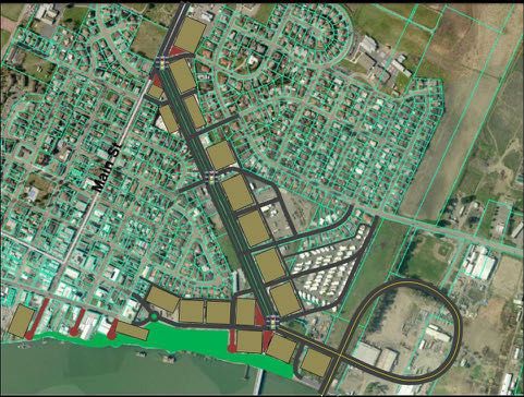
Table of Contents
EXECUTIVE SUMMARY            1
     INTRODUCTION            4
     THE COMMUNITY SPEAKS    6
STATE ROUTE 12               9
A FRAMEWORK                  32
A VISION FOR DOWNTOWN &
THE WATERFRONT               45
MAIN STREET                  63
PARTNERING FOR PROGRESS      68
IMPLEMENTATION               75
ACKNOWLEDGEMENTS             78
     AIA DESIGN ASSISTANCE   79
     NATIONAL TEAM ROSTER    80
     THANKS!                 84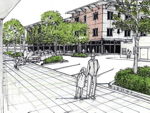
Executive
Summary
EXECUTIVE SUMMARY AND LESSONS LEARNED                                                           Making downtown more successful obviously serves the downtown business
                                                                                                community. While the R/UDAT focused on ways to support business investment,
RioVision and the City of Rio Vista requested assistance in exploring:
                                                                                                vitality, and partnerships in the downtown, it is obvious that the strength of downtown
                                                                                                and a commitment by city government and others to partner is key to the economic
1. Recommend a preferred State Route 12 alignment to serve a replacement                        strength of the entire city. Even businesses with no directly downtown connection,
Sacramento River Bridge. The R/UDAT considered both the alignment of Route                      such as industrial enterprises in the industrial park and elsewhere, still benefit from a
12 and equally, if not more import, the design of SR 12 and how it connects to the              vibrant community, a financially stable municipality, and a productive work force that
community and serves placemaking and mobility needs.                                            wants to live in Rio Vista.

2. Build a viable business community in the downtown study area. The R/UDAT                     Rio Vista has done a great deal of planning and continues to make investments in
examined actions from bricks-and-mortar improvements to creating a stronger                     downtown, including the downtown waterfront. Downtown and the waterfront
identity, organizing downtown, adding promotional efforts and events all to bring               should not be considered two different areas- downtown is Main Street and Front
people back downtown, and give them something to do when they get there.                        Street. Downtown and SR-12 feed off each other and benefit or suffer together.
                                                                                                There are a huge range of opportunities for downtown, including simple façade
3. Revitalize downtown Rio Vista commercial core and waterfront. As RioVision’s                 and alley improvements, community partnerships and risk sharing, zoning reform,
application states, Rio Vista has “a charming but lackluster core city and waterfront.”         organizational improvements, and waterfront improvements. The waterfront will
Rio Vista needs a vision for what downtown and the waterfront can be that extends               catalyze downtown through downtown expansion, restaurants that help provide
beyond its current Waterfront Specific Plan. The R/UDAT examined many other                     access to the river, dense housing to build downtown’s critical mass, built around
opportunities for stronger physical and visual connections.                                     public space.

4. Connect outlying areas and build a sense of a single community and a sense
of place.

The R/UDAT explored how physically, socially, and culturally the Trilogy at Rio Vista,
other newer residential areas, and the planned Rio Vista Army Base Redevelopment
Area can fell more connected to the rest of the city. What can appear to be four distinct
challenges, however, is really one interconnected challenge.

SR-12 functions as the edge of downtown, but functionally it should be in the
downtown and not downtown’s edge. SR-12 is the edge because it serves as the
barrier or the knife artificially dividing downtown from an important downtown
neighborhood. What City plans refer to as Rio Vista South and Rio Vista North would
simply be Rio Vista if SR-12 united the community instead of dividing it. If SR-12 is
already a knife cutting through the city, imagine the problems if the road becomes a
divided four lane highway, with the easterly half-mile elevated to ramp up to a new
much higher bridge span.

SR-12 can be tamed, however, in both the short and the long term with a community
multi-way boulevard that can serve both movement, which is critical, but also
placemaking, a function that is currently absent on SR-12. Such an approach would
not only remove the threat to the City from an SR-12 remake, it will strengthen
downtown and provide a long term economic development potential. If a new bridge
is 15+ years away, there is time to get it right and provide new economic development
opportunities for decades to come.
                                                                                                Downtown and Downtown First Investments

                                                                                            2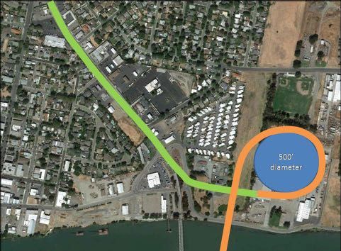
Adopting a Downtown First Policy that all public buildings, non-profit facilities,            Rio Vista asked for a R/UDAT strategically focused on actions and implementation.
and private commercial investments are expected to be downtown (defined here to               “We are doers, not dreamers,” they reported. Any strategic focus still needs a unifying
include Main Street, Front Street, and SR-12 between Main Street and Front Street)            vision, but a vision directly connected to action and the timing of those actions.
focuses on downtown as Rio Vista’s economic and community focal point and helps
define the community. If the default is downtown, then such investments should be             Timing is everything. Rio Vista needs to move forward at several time scales.
made elsewhere after an analysis showing that a downtown location is not viable and
other locations would better benefit the entire community. Commercial investment               • Quick start projects can start almost immediately, are very low cost, use minimal
near Trilogy and Riverwalk, for example, should be limited to local convenience                  political capital, yield immediate results, and build momentum critical for larger
commercial (under 5,000 square feet) while social services, community and senior                 longer term steps. For example, quick starts can include volunteer and willing
centers, and city hall should all be downtown.                                                   investor façade improvements, alley improvements, the easy zoning changes,
                                                                                                 some pop-up arts and businesses, community prioritization of longer term
Likewise, there are two broad approaches to strengthen the shared sense of place                 projects, and starting some key partnerships.
and community. First, make downtown Rio Vista clearly a place of the heart for
                                                                                               • Seed projects are projects that might not be replicable and might be one-time
all residents. Paradoxically, strengthening the downtown or village center is also
                                                                                                 opportunities, but they can create success and catalyze other projects. For example,
extremely effective at improving connections to the natural and working landscape.
                                                                                                 a seed project could be an artist-in-residence in a vacant downtown space, a Rio
Downtown can be better focused on the river, more attractive to newcomers to
                                                                                                 Vista crowd-funded waterfront investment, or building the funded elements of the
reduce future pressures to convert farmland to subdivisions, and provide a home for a
                                                                                                 waterfront promenade with an eye to how it fits the recommended waterfront
farmers market and other farm-to-market efforts. When residents and visitors identify
                                                                                                 improvements.
their downtown as the focal point of the community, as a place they love and will fight
to strengthen, then Rio Vista will become one community.                                       • Medium and longer term projects are those that unfold over many years. Some
                                                                                                 take years because of the amount of resources required, but others take a long
Second, build the events and shared activities that organically create a sense of                time because there are great risks in going too fast. For example, some kinds of
community. One citizen reported “the circle of caring has been fragmented.” Events               investment in the waterfront and along SR-12 are critically needed and will make
and anything that brings the community together, whether they be the Bass Festival,              Rio Vista stronger, but moving too quickly ahead of the market can leave downtown
new Main Street and waterfront events, or jointly working on RioVision, creates that             with even more competition and not enough new spending. Timing is everything.
sense of community.

                                                                                              The participation, support, excitement, energy, and commitment the community had
                                                                                              for the R/UDAT process is clear evidence of the community’s ability to come together
                                                                                              and move forward.

Events should make downtown fun and help build a positive reputation. A windswept
beach isn’t for Rio Vista when the wind blows, but what is the local equivalent that
captures the energy the Bass Derby brings to town?

                                                                                          3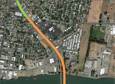
INTRODUCTION                                                                                       cycling in Rio Vista and the nearby Delta serves residents and visitors from areas as far
                                                                                                   as San Francisco, and the waterfront provides great, if largely untapped, opportunities.
Rio Vista is a small Solano County city with a charming little downtown on the
Sacramento River/Deep Water Channel waterfront, about halfway between Oakland
and Sacramento. Rio Vista is the Gateway to the Delta (Sacramento River–San Joaquin
River Delta). It is located at the base of the Montezuma Hills, whose 750 wind turbines
in three wind farms creates a scenic backdrop to the City.

Downtown Rio Vista has great bones, but it is not especially vibrant. After a near
municipal fiscal collapse in 2009, Rio Vista and its downtown have risen again and are
continuing to get stronger.

RioVision, in cooperation with the city and many community sponsors, requested
a Regional/Urban Design Assessment (R/UDAT) for a strategic assessment of its
opportunities. In their R/UDAT application the community reported:

The downtown has a 1950s undisturbed look and feel to it… Many buildings have
facades that obscure the charming brickwork of years past and some buildings were
victims of 1960s “upgrades” that now look dated. Storefronts have little curb appeal…

Rio Vista has some great opportunities, driven by an increasing population, an increase
in drive-by traffic, and opportunities to improve downtown and the waterfront. It can
be a great little city. There are some recurrent themes for Rio Vista’s story that can             Serving the Delta Boating: Rio Vista today and Old Rio Vista 1865.
help define the city. A small historic downtown, a rich history of visitors (e.g., Rio Vista
was a favorite for Jack London), a waterfront with potential, an iconic bridge, wind               Downtown Rio Vista is, however, threatened by competition from a potential new
generators helping define the Montezuma Hills, and a market town serving a vast                    commercial area elsewhere in town, an eventual replacement of the California State
agricultural region, and the ecological diversity of the delta.                                    Road 12 (SR 12) Sacramento River Bridge and related realignment of SR 12. Although
                                                                                                   more than a decade away, the need to plan for a realignment of SR 12 to serve a new
                                                                                                   bridge, and the resulting impacts on the community was the catalyst for Rio Vista
                                                                                                   applying to AIA for a R/UDAT.

                                                                                                   SR 12 currently crosses the Sacramento River/Sacramento River Deep Water Ship
                                                                                                   Channel on a draw bridge at the edge of downtown Rio Vista. With a steady increase in
                                                                                                   motor vehicle traffic, commercial shipping, and recreational boating, there are plans
                                                                                                   to eventually replace the drawbridge with a much higher fixed span bridge. A higher
                                                                                                   bridge requires a long approach ramp, potentially creating an elevated highway
                                                                                                   extending over one-half mile west of the bridge.

                                                                                                   The AIA R/UDAT application referred to Rio Vista as “centrally isolated,” a quote which
Themes from “Shopping in Downtown Rio Vista.”                                                      resonates with the community. Less than an hour from Sacramento or Oakland yet
                                                                                                   too small and too isolated to be attractive for many kinds of medical uses (there are
Rio Vista is the gateway to the Sacramento River Delta and in the base of the                      currently no doctors’ offices in Rio Vista) and many other basic services. Rio Vista
Montezuma Hills, ecologically and recreationally some of the most interesting areas                is the gateway and the economic center of the Delta, yet a huge percentage of
in California. It is a comfortable and safe community. Downtown is walkable, the river             retail, entertainment, and medical spending leaks to other communities. This limits
provides fishing, windsurfing, sailing, boating, and passive recreation opportunities,             community services, jobs, and municipal sales tax revenue.

                                                                                               4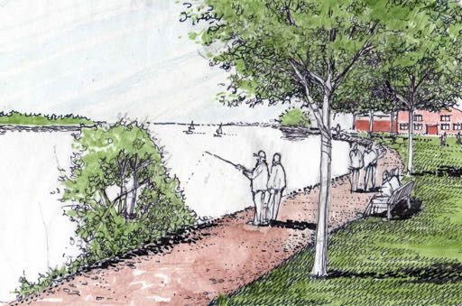
Rio Vista has a great opportunity to focus on downtown
                                                                                                                and its waterfront to transform downtown. Downtown
                                                                                                                cannot live or die based on drive-by traffic and, even
                                                                                                                though retail will never be what it was 50 years ago, it
                                                                                                                can serve both the entire community and the Delta.
                                                                                                                Market interests have started some reinvestment in
                                                                                                                downtown and there are lots of opportunities, but
                                                                                                                downtown needs additional actions to be successful.
                                                                                                                New development planned for Rio Vista will increase the
                                                                                                                population significantly, creating opportunities for new
                                                                                                                customers and partners but also potentially creating
                                                                                                                new commercial areas further west on SR-12 that could
                                                                                                                compete with if not devastate at least some submarkets
                                                                                                                downtown.

                                                                                                                Rio Vista’s rapid past and future residential growth,
                                                                                                                restarted after the recession collapse, creates new
                                                                                                                opportunities for downtown. At the same time, however,
                                                                                                                the population within easy walking distance of downtown
                                                                                                                has almost certainly declined due to demographic
                                                                                                                trends and the lack of pedestrian accommodations
                                                                                                                and infrastructure for crossing SR 12. SR 12 serves as a
                                                                                                                barrier splitting the community and preventing many
Caltrans SR 12 alignments, with the elevated approach ramp extending over a half mile from the ship channel.    connections. Equally significantly, the new development,
                                                                                                                especially the large gated Trilogy at Rio Vista with its
                                                                                                                own entertainment and restaurant, has very weak
                                                                                                                physical connections, especially for non-motorized trips,
                                                                                                                to downtown and historic Rio Vista, creating disparate
                                                                                                                communities and social disconnection.

Rio Vista’s population reflects both the large number of retirees living in the community and the lack of job
opportunities for young workers at the start of their careers.

                                                                                     5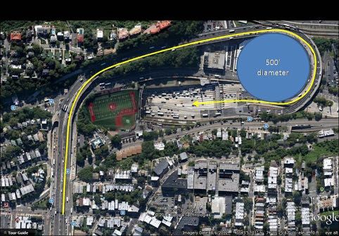
THE COMMUNITY SPEAKS
R/UDATs are built around a community participatory process. In Rio Vista,
approximately 50 people attended targeted focus group meetings and 350 people
attended a Town Hall-style listening meeting, and a handful of people sent in notes
with their own thoughts. In the Town Hall meeting, the community answered a few
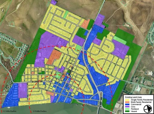
key questions...community responses are represented by the adjacent graphic and by
the graphics on the next two pages.
RioVision did extensive outreach to invite the community and diverse stakeholders to
participate.
The community expressed great concern about a SR 12 limited access highway and a
new Sacramento River Bridge elevated approach ramp cutting an even deeper knife
through the heart of the community.
The community also stressed the importance of strengthening the sense of community
and sense of place. Representative comments included, “There are a couple of senses
of place, one for Rio Vista and one for Trilogy. We should be one community.” “Growth What is Rio Vista; what is the soul of the community?
has not been organic. The eclectic mix of housing is part of the charm of the organic
growth in the older neighborhoods.”“Our kids are no longer the center of the universe
in the built environment.”
When asked what would reinforce community character, the residents focused on
four concepts:
1. A stronger connection to the natural and agricultural landscape.
2. A more vibrant downtown that is the clear focal point of civic and community
life.
3. A vital and vibrant waterfront that strengthens downtown and the connection
to the river.
4. A small town feeling that reinforces the interconnectivity of the community.
6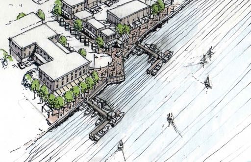
What most important changes we should see within two years?

                                                              7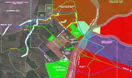
What most important changes we should see within ten years?

                                                              8
State Route 12
THE HIGHWAY 12 CONUNDRUM: IT’S TIME TO MOVE ON                                                   Severed Neighborhoods
SR 12 serves as both the lifeline of Rio Vista and its biggest obstacle. It serves as the        Closer to downtown, SR 12’s speeds are a particular threat to community vitality. The
primary means of access by car and bus between Rio Vista and State Routes 84, 160, 113,          short 0.6 mile stretch of highway between Front Street and Drouin Drive maintains
and 4, as well as Interstates 80 and 5, which allow Rio Vistans to access to commerce,           a 45 mph posted speed limit on a roadway cross-section that averages over 80-feet
entertainment, and jobs in Fairfield, Sacramento, Lodi, Antioch, and beyond. However,            wide. Such cross-section and speeds are entirely inappropriate for pedestrians, with
SR 12 carries as many as 20,000 cars per day, and the California Department of                   data clearly showing such size and speed almost always results in pedestrian fatality
Transportation (Caltrans) and the Salano Transportation Authority (STA) project this             when there is a conflict.
volume to increase substantially as planned residential development comes online
throughout the region. This traffic cuts through the heart of Rio Vista, dividing its
historic downtown grid from newer subdivisions to the north – compromising a sense
of community.

A Community Divided
Residents often refer to the community as two parts: Rio Vista and Trilogy. Certainly
the development of the 3,000-unit Trilogy at Rio Vista subdivision has added inland
weight to the community’s population, but the presence of Trilogy in itself is not
the biggest factor driving the distinction of two communities within one. Trilogy is
only a short 7-minute drive, 15-minute bike ride, or 45-minute walk from downtown.
These are typical distances to travel within a community – similar to traveling from the
White Elementary School to Sandy Beach Park. Trilogy’s separation from downtown
is much more the result of a lack of comfortable and safe connections. SR 12 serves
as the primary and most direct connection between Trilogy and downtown, but the
roadway is not a complete street, serving only as a conduit for cars with no sidewalks
or bike facilities, with posted speeds between 45 and 55 mph.

                                                                                            10
For their own safety, pedestrians mostly keep away from SR 12. Unfortunately, this
means they don’t walk across or along a road that is in the heart of their community,
separating the downtown from most of its residential neighborhoods.
Both near downtown and out to Trilogy, SR 12 serves as a barrier to community
integration. Overcoming this barrier is key to the future success of Rio Vista.
A History of Debate
Unfortunately, the debate over the future of SR 12 has focused for decades on its
expansion and greater throughput. Caltrans and the STA view it as a critical highway
link between I-5 to the east and I-80 to the west, short-cutting about 36 miles off a drive
through Sacramento – though the time savings is only 25 minutes today (45 minutes
versus 70 minutes), due to the lower speeds of SR 12. Caltrans has designated SR 12
a Service Transportation Assistance Act (STAA) highway, allowing it to handle trucks Under State Bill 375, California jurisdictions are required to have Climate Action Plans
longer than the legal limit – ostensibly for the carriage of specialized products that for future development, otherwise developers must prove they are undertaking
must be able to connect between I-5 and I-80, which may include military shipments measures to control greenhouse gases, which generally result in greater density,
to Travis Air Force Base, agricultural product, and even large loads associated with pricing incentives, and/or multi-modal improvements to reduce VMT. This legislation
Rio Vista drilling industries. Relinquishment of Caltrans control over this facility for its has had dramatic effect on the form of future development. Residential subdivisions
entire length is not currently permitted. like Trilogy and Homestead would not be compliant with the law today, due to their
heavy reliance on the automobile. Planned developments like Brann Ranch, Riverwalk,
Regional travel demand modeling conducted by Solano County’s travel demand and Del Rio Hills also appear unlikely to meet the requirements of this law as currently
model has concluded that the roadway will experience 50-percent increases in conceived.
volume by 2030 with no roadway changes, resulting in extensive delays and queues
in many places, including Rio Vista. However, this projection is in direct conflict with Rio Vista’s 2001 General Plan is used, however, as the basis for travel projections in
travel trends, as well as the 2035 Regional Transportation Plan (RTP) of the Bay Area’s this part of the County, and the number of units projected at prevailing driving rates
Metropolitan Transportation Commission (MTC). Overall vehicle miles traveled (VMT) predicted as many as 60,000 daily trips. While many of those trips stay within Rio Vista,
as well as VMT per capita in California have been declining since 2004, ahead of the number is a direct factor in the County’s predictions of 30,000 cars per day on SR
national trends which have been in decline since 2006. These declines began before 12 by 2030. It is particularly noteworthy that this volume is predicted without any
the last recession and have continued downward years after the recovery began. roadway improvement. As often happens with traffic models, road capacity drives
increased travel rates – regardless of additional development. As such, the predictions
11for SR 12 volumes increase more substantially if SR 12 is widened. By converting the highway to 4-lanes, including Even a casual reader should see many areas of concern in
a new mid-level bridge, roadway volumes increase to 45,000 cars per day; a high-level bridge results in 55,000 cars the above numbers. Firstly, projected SR 12 traffic is based
per day. on a 2001 plan for development that has not evolved
and now may not be permitted under SB 375. Secondly,
Such traffic growth projections – a self-fulfilling prophecy of “build it and they will come” – are certainly possible traffic modeling is consistently faulty is its assumptions
if driving is made easy and people chose to drive. The United States was crisscrossed with highway expansion that traffic must grow, contrary to all evidence for the last
projects in the 1980’s and 90’s that were built to reduce congestion, only to see the extra capacity filled within a few decade. Thirdly, any expansion of SR 12 – and particularly
years. Looking at history, expanding SR 12 would presumably attract more driving, and the model says a high-level a $1B investment in a river crossing – would be in direct
bridge attracts even more regional through trips. The travel demand model’s default assumption that population opposition to the MTC’s RTP for 2035. Simply put, without
growth and easier driving leads to more driving, however, has been entirely disproven for nearly 10 years, STA and a bigger SR 12, traffic growth may not occur, especially if
Caltrans have been limited by modeling tools that have been slow to respond, much like many U.S. jurisdictions. In new development is denser, incentivized against driving,
fact, year after year, based on some of those same models, the Federal Highway Administration (FHWA) continues and provided with multi-modal options.
to predict travel growth that is not happening.
A Re-Cast Bridge Decision
Given questionable traffic projections, high cost, at least
10 years of planning and design delay, and the immediacy
of correcting SR 12’s speed and safety concerns, it is not
in Rio Vista’s best interest to further debate the alignment
and size of the river bridge without questioning some of
these assumptions. If the bridge is ever constructed, it
must be 150-feet tall with 3,200-foot long approaches
that would have a dramatic visual impact on Rio Vista,
effectively cutting off the downtown from the rest of the
community. If it were 4 divided lanes, this effect would be
continuous through the community, even after coming
to grade.
Vehicle miles traveled in trillions as tracked by FHWA’s Travel Volume Trends, compared to projections
from the U.S. DOT “Conditions and Performance Report to Congress.”
12Crescent Drive before proposed bridge construction.
Conceptual rendering of Crescent Drive after proposed bridge construction.
13The highway would become a far more significant barrier than it already is –
permanently and negatively impacting the viability of neighborhoods on
WISCONSIN BYPASS STUDY:
either side of it. As such, it should not be considered on any alignment that This paper reviewed prior studies of the economic impact of highway bypasses, based
runs through the heart of Rio Vista, unless it can be substantially reduced in on prior research conducted by the Wisconsin Department of Transportation as well as
size and height. Only options that avoid the developed area of Rio Vista are several other studies carried out in other states (Kansas, Iowa, Texas, and North Carolina).
viable for the future of the community, such as the most northern or southern
alignments studied in the last Caltrans study of SR 12. Summary of Findings on Impacts of Highway Bypasses:
• “The wide range of highway bypass studies carried out around the country provide
a generally consistent story. They indicate that highway bypasses are seldom either
devastating or the savior of a community business district. The locational shift in
traffic can cause some existing businesses to turn over or relocate, but net economic
impacts on the broader community are usually relatively small (positive or negative).
Communities and business districts that have a strong identity as a destination for
visitors or for local shoppers are the ones that are most likely to be strengthened due
to the reduction in traffic delays through their centers. However, there is also a broad
perception that adequate signage to the bypassed business center is an important
need (and concern) for ensuring its continued success.”
Dennis Leong, Wisconsin Department of Transportation and Glen Weisbrod, Economic Development
Research Group, “Summary of Highway Bypass Studies,” Wisconsin Department of Transportation,
December 2000.
CALTRANS BYPASS STUDY (KEY POINTS):
• Stay visible from the bypass, either visually or through signage – Caltrans may help
with this.
• Keep the bypass as close as possible/acceptable.
• Highway oriented communities who cater directly to highway traffic, with gas, fast
Fears of negative economic impact are not born out in any case study food, and transportation businesses as economic staples have difficulty transitioning.
data, especially since recent studies of SR 12 show that only 2-3 percent of Quick service businesses such as gas and fast food likely need to relocate.
pass-through trips stop in Rio Vista, and those are mostly concentrated on • Residential & tourist communities benefit from reduced traffic and improved safety.
roadside businesses which would relocate to locations near the new highway Visitor services such as motels and antique/curio shops are positively affected. The
exits. In fact, there is more evidence of positive economic impact from highway downtown must capitalize on being a destination through marketing, redevelopment,
removal in downtowns than from retaining highway access in one place versus parking, sidewalks, etc.
another nearby. • Regional market communities (e.g., big box stores, auto dealers, and hospitals)
experience no little to change, unless access improves, bringing in more business.
The question that Rio Vista should be asking is not “where should a new bridge
go” but rather “what do we do if the bridge remains?” For no less than 10 years • Other economically based communities (e.g., agriculture, manufacture, and
– and potentially much longer – SR 12 in the heart of Rio Vista will remain. government) experience little to no economic impact.
As it exists today, it severs the community, limits non-motorized travel, and • Most business types are not affected.
represents a real threat to the safety of our children. Within the borders of Rio System Metrics Group, Inc. in association with: Cambridge Systematics, Inc.; Economic Development
Vista, the community receives no benefit from keeping SR 12 a 50 mph facility Research group, Inc.; HLB Decision Economics, Inc.; Judd Associates, “California Bypass Study. The
versus a 30 mph facility – the difference in drive time from the river to Trilogy Economic Impacts of Bypasses Volume 1: Planning Reference,” California Department of Transporta-
would be only 2 minutes (3.2 versus 5.2 minutes). However, the difference tion, Transportation Economics, May 2006.
14between 50 and 30 mph is the difference between a safe community street and an auto-oriented barrier, intersections, the worst crashes have been on open highway. Such
dangerous to walkers and bikers and impactful on community vitality. A new discussion is necessary. conditions do not exist near downtown Rio Vista, where some of
the widest and most pedestrian-unfriendly sections exist, and this
stretch of the highway has received little attention from Caltrans.
A Boulevard for the Future The City had in-pavement warning lights installed at the only
SR 12’s value to Rio Vista is as a connection to regional markets and services. In less than an hour, SR crosswalk east of Main Street, but it does not operate today and
12 provides access to roadways connecting residents with hundreds of shopping destinations, dozens of has been ineffective at substantially improving the pedestrian
downtowns, a multitude of entertainment options, and thousands of jobs, including the downtowns of environment – mostly due to the significant length of the crossing
Sacramento, Napa, Berkeley, and Stockton, as well as nearer communities like Fairfield, Lodi, and Antioch. with absolutely no protection from vehicles.
The remainder of this section is hostile at best, with discontinuous
sidewalks along and intersecting SR 12. Large swaths of pavement
are simply painted with hash markings to help define the two
travel lanes with center turn lane, which require far less pavement
than is in place.
A treatment that has been use in numerous locations around
the country to improve pedestrian safety and calm traffic while
The ability to travel through Rio Vista itself quickly is of almost no value to the community. In fact, slowing maintaining vehicle capacity is the “multi-way boulevard.” The
down pass-through traffic and making regional motorists take a look at Rio Vista for an extra two minutes design has been in place in many cities for decades. It involves
on each trip may result in a much higher percentage of trips taking a moment to come into downtown. At separating local entering and exiting traffic from through traffic
the very least, slowing traffic enables people to cross SR 12 by foot, bike, and car much more easily than by installing a planted median on either side of the through lanes,
they can today, helping re-connect severed neighborhoods. creating parallel one-way “carriageways” on either side of the
main line. The channelization has great benefits to all roadway
To date, Caltrans’ reaction to safety concerns on SR 12 has been entirely focused on head-on crashes users: through traffic encounters less local movements, which are
occurring on high-speed 2-lane sections – mostly outside Rio Vista’s borders. While most crashes occur at separated by the outer medians, helping to reduce crashes; local
access is managed better, forcing most entering and exiting traffic
15to convert to right-in right-out movements, with lefts accommodated
at the next intersection; on-street parking becomes viable when
separated from high-speed through traffic by being placed on the CATHEDRAL CITY, HY 111 OR EAST PLAM CANYON DRIVE
carriageway; bicycles find a new slow-speed shared street in the Widening was required along much of the highway to improve traffic flow. However, in the city’s
carriageways; and pedestrians have significantly less roadway to downtown, leaders felt a multi-way treatment would be an opportunity to stimulate economic
cross between medians, typically able to cross carriageways without prosperity and beautification while enhancing capacity.
a signal.
For this section of Highway 111 the 2002 traffic statistics were an average ADT of 39,450 (Average
Daily Trips) with an average Daily Capacity (Veh./Day) of 45,000. The level of service was mostly F.
The build out / improvements were resulted an average ADT of 43,800, increasing to 52,000. The
resulting level of service averages E.
The city’s Downtown Revitalization Steering Committee (appointed by the City Council) hired
consultants and developed a design for the benefit of the city and the road. Caltrans, however,
rejected the plan. The city utilized Caltrans’ relinquishment program to take over the section of
highway and implement their plan. The financial support of the Riverside County Transportation
Commission and Coachella Valley of Governments were instrumental in this project.
Octavia Boulevard in San Francisco replaced the Central Freeway.
Today it still carries over 45,000 cars per day. The surrounding
neighborhood has entirely changed, becoming one of the most
energized places to live in the city.
A multi-way boulevard treatment on SR 12 in Rio Vista would be
a tremendous benefit to the community and overall safety while
preserving if not improving existing roadway capacity. Between
Main Street and Front Street, the existing roadway cross-section is
sufficiently wide to accommodate full multi-way treatments with
parallel carriageways that have parking and shared-use travel lanes
for almost its entire length.
16Cross section of existing Route 12.
Proposed redesign of Route 12.
17While Caltrans has multi-way boulevards on its state routes in Cathedral City and Chico, the With redevelopment along this corridor, Rio Vista has an opportunity to
agency has not designed or funded their construction in California to date. However, the concentrate a mix of uses right in its core, as opposed to its undeveloped
department is now subject to the passage of California’s “Complete Streets Act,” which requires edges where access is more restricted to automobile travel. Such
the consideration of all modes of transportation in roadway projects. Several policies and development would touch both Main Street as well as Front Street,
guidebooks have been produced with more on the way, and in-state engineering firms continue completing a triangle of mixed-use activity and development – as well as
to be responsible for designing multi-way treatments out of state. Many of the multi-way an attractive downtown without an end, so to speak.
treatments suggested in this report can be installed simply in paint, with smaller crossing-islands
at crosswalks and landscaping barrels at key points where full planted medians might otherwise
be installed. For low cost, the City can create a noticeably traffic-calmed and safer SR 12 in the A Smaller Bridge?
heart of its community if it begins the conversation with Caltrans, the STA, and the MTC. Given The introduction of a multi-way boulevard on SR 12 embraces the goals of
mandates such as SB 375 and the Complete Streets Act, now is an excellent time to implement SB 375 by promoting multi-modalism and opening up opportunities for
lasting positive change on Rio Vista’s highway. denser development in the heart of the community. Such development
is reflective of regional and national trends towards more compact and
walkable communities, which increase and preserve land values while
Completing a Triangle reducing healthcare costs and emissions. In Rio Vista, it is quite possible to
Converting SR 12 from a highway to a slower boulevard (with potentially greater capacity) is see this trend evolving long before a replacement of the bridge is necessary.
more than just an opportunity to mend community divides. It represents a great economic It is possible that continued downward VMT trends and policies like SB 375
development opportunity. By buffering the noise and speed of the existing highway with will meet or exceed the RTA’s goals for 2035, which would necessitate an
tree-lined medians and parked cars along a boulevard, the character of parcels along this conduit important consideration for Caltrans: why build a 4-lane high-span bridge?
entirely changes. Underutilized parcels can become commercially viable, and upper floors would While age, maintenance, and river navigation will likely necessitate bridge
be entirely compatible with many types of residents. The large parcels along the boulevard replacement, traffic may not. It would be wise for the Rio Vista of tomorrow
provide many opportunities to re-envision this corridor and promote new connections across it to consider alternatives that would be more in line with their walkable
between downtown and the neighborhood to the northwest. community.
While a smaller two-lane bridge with no more traffic than today might not
need to be diverted out of town if it connects with the multi-way boulevard,
it will likely still need up to 3,200-feet of ramping, which would destroy
the multi-way boulevard treatments and compromise any development.
It is not necessary, however, to consider alternative alignments if
alternative configurations are possible. One common treatment for large
grade-separated facilities is to loop the ramping back upon itself to lose
altitude in a compact space.
This approach could be applied to a high-span bridge of any size very
effectively, bringing it to grade at the water’s edge to connect seamlessly
with a lengthened multi-way boulevard – preserving community
connectivity while avoiding visual impacts between neighborhoods, the
downtown, and the river. An inside diameter of 500-feet is sufficient for
the over-size trailer loads permitted on SR 12 maintaining 30-35 mph in
standard highway lane widths.
While such an approach would also work for a full 4-lane divided highway,
unless Caltrans is willing to keep the multi-way boulevard or other
heavily-calmed treatment in place through the heart of Rio Vista, it is not
recommended to maintain such a facility close to downtown.
18Lincoln Tunnel entrance, Hoboken NJ US Route 1/I-93 Interchange, Boston MA
Elevated structure and ramping in orange; ground-level roadway in green.
19A Triangle of Gateways to Downtown
In the future, if Rio Vista has successfully developed a multi-way
boulevard along SR 12 between Front and Main, the nature of
through trips in the community will have changed. No longer
will a drive through downtown be a quick highway pass-by
but rather an enjoyable interlude along a longer drive. Once
upon a time, SR 12 came right down Main and Front Streets
through the heart of town. While the traffic volumes were
unsustainable, the visibility of downtown was at its height.
The current SR 12 alignment in downtown has bypassed the
downtown for years, but its calming as a multi-way boulevard
would bring an opportunity to resurrect the visibility of Main
and Front Streets that they once had.
If during the installation of a multi-way boulevard, the
intersection of SR 12 and Main were realigned to emphasize
the straightness of the historic corridor of Main Street, while
de-emphasizing the dominance of the SR 12 bypass, the
future roadway infrastructure could well-serve a reinvigorated
downtown as a regional attraction – not a cross-roads. By
forcing approaching motorists from the west to deliberately
make a left-turn onto the boulevard, the desire line of historic
Main Street will be emphasized, as well as a straight view to
the water from near Bruna Vista Park. This new intersection
can become a valuable gateway to downtown Rio Vista.
Furthermore, the boulevard may present a similar
opportunity at Front Street when a new bridge is built, either
in/near the existing alignment or outside of the community’s
routes that provide intra- and inter-community service. Delta Breeze, which is based out of a facility adjacent
core. Without the need to ramp upwards to a structure, the
to the City’s northern wastewater plant, operates several 16-passenger cut-away vans, which have comfortable
boulevard can connect directly to River Road or to the looping
seats, regional transit information onboard, and bike racks. The operation is grant-funded.
ramp of a narrowed high-span bridge further to the north.
Motorists from SR 12 to the east and/or from River Road and
Route 84 to the north would also be aligned straight onto Within town, Route 51 provides dial-a-ride service, whereby any resident can call for a pick-up at least 30
Front Street, requiring a deliberate right-turn to proceed on minutes in advance of their travel time and be dropped-off anywhere in Rio Vista. Connecting service outside
the boulevard. Similar to the Main Street intersection, this Rio Vista is provided by express Routes 50 and 52, which connect with Fairfield/Suisun City and Antioch
approach re-emphasizes the importance and value of the respectively. Route 50 passengers have access to the Capital Corridor and Amtrak service at Suisun City, which
downtown waterfront while calming traffic entering the connects Rio Vista transit riders to Sacramento, Oakland, and the full extent of the Amtrak system. Route 52
community. With another gateway treatment, Rio Vista may passengers have access to Bay Area Rapid Transit (BART) at Pittsburgh/Bay Point station, with frequent service
have a truly wonderful presence. into San Francisco and other Bay Area destinations.
Embracing Community Transit
For several years, Rio Vista has been served by several transit
20Due to the limitations of available funding, every Route is restricted in its overall hours of
operation. Express Route 50 to Suisun City only has two morning runs spaced three hours apart,
plus a midday run. Only one bus returns travelers to Rio Vista near the evening peak hour. Express
Route 52 to Pittsburgh/Bay Point has only one run in each direction timed near the peak hour.
Route 51 can have more frequent service, but it is only available between 9:30am and 1:30pm.
Need for Change
The value of expanding transit service to Rio Vista will grow as walkability improves but especially
as demographic changes continue in the near future. Auto ownership rates in the U.S. are
declining dramatically due to the aging of Baby Boomers and the digital lifestyles of Millennials
who much prefer the convenience of nearby interaction, rather than any time spent in a car. The
movement of these large segments of the population into downtowns is pronounced, and the
most successful downtowns are offering quality transit that these populations are embracing
readily.
21A similar approach to Route 51 would be very effective. Today, it can provide service
effectively every 30 minutes anywhere in town, but it has no fixed route presence and
therefore no need to run on Main or Front unless called there. A successful approach
used by many small communities with similar characteristics is to implement a limited
fixed route with deviated ends, operating on a regular schedule. In Rio Vista, this fixed
route could begin on the spine of Main Street between City Hall and the food market.
Service would depart either end on a fixed schedule every 15 minutes and run the
length of Main Street. At the opposite terminus, the bus could then depart or “deviate”
to any dispatch calls before returning to the spine in 15 minutes, traveling the length of
Main Street again in the opposite direction before deviating to potential destinations
beyond the other end of Main Street. Two simple dispatch zones served from either
end of the spine would be able to be served every 30 minutes, offset 15 minutes. This
provides the same level of service transit riders experience today, but adds a brand
new regularly-time presence on Main Street, with a bus anyone can hop on traveling
in one direction or the other every 15 minutes during the bus’ service span.
Over time with additional funding, one additional vehicle can make one-way frequency
every 15 minutes, and extending the span of service into the evening would better
mesh with the transit lifestyles of more potential riders.
Straightening Express Routes
Unfortunately, the frequency and structure of transit in Rio Vista is not well-suited to
these generations. The express services are entirely designed to serve only those who One of the biggest impediments to effective inter-city transit is the need to serve
simply cannot drive and don’t have an alternative, which helps explain their winding front-door destinations within Rio Vista. All riders are expected to walk to a stop
routes through downtown, Homestead, and Trilogy. Meanwhile, the dial-a-ride (unless they have called for a front-door deviated pick-up), but the current road and
service is also oriented to those who cannot drive: it is inconvenient for short trips, sidewalk network in Rio Vista makes this difficult for any distance. Homestead and
and waiting 30 or more minutes for a trip that must be completed within a 4-hour Trilogy could be within a 10- and 5-minute walk respectively of “straightened” service
early-day span is simply not well-matched with many lifestyles. that remains on Main Street/SR 12, but the complete lack of adequate walking or
biking facilities makes this impossible, so each express route must meander through
these neighborhoods, adding delay and rider frustration.
Delta Breeze is conducting a study of its route system, and Rio Vista should work
proactively to think about the future of community transit. Some simple strategies
may be very cost-effective for Delta Breeze while serving many growing downtown
needs.
Improving In-Town Service Options
The operation of Route 50 and 52 is not likely to change in the near future, but its
deviated response within town and to Isleton represents a type of service that could
be introduced on the Route 51 to dramatically change the visibility of transit to Rio
Vistans and downtown businesses. Each of the express routes runs down Front and
Main streets, but with limited early morning or late afternoon service, the bus is
largely transparent to all but those who rely on the service. If service on these streets
were more frequent, the potential to serve transit lifestyles would greatly increase.
22In order to someday straighten these routes, the City must work proactively to install walking and biking Establishing Good Pedestrian Design
connections north-south between these neighborhoods and Main Street, and it must work to ensure that future
Streets are home to more than just motorized vehicles.
developments also provide these connections – preferably as many as possible on multiple grid-like desire-lines,
Many cities and towns across the nation are adopting
as opposed to through a single gateway or intersection. As regional growth drives increasing demand for these
“Complete Streets” policies that support balanced,
services and eventual frequency improvements, both express routes overlap easily with the deviate fixed-route of
multimodal street design for automobiles, pedestrians,
a revised Route 51 along Main Street and Front Street, truly emphasizing the presence of transit in Rio Vista.
cyclists, and transit. The California Complete Streets Act
is intended to promote this in all local jurisdictions.
Future Development
Complete streets are always unique to the community,
With the redevelopment of the Army Base, additional housing subdivisions, waterfront redevelopment, and other context, and purpose served. Still, all complete streets
opportunities, there may be many more potential riders that Delta Breeze can serve by building services off of policies and projects share a focus on accommodating
the transit spine concept. By ensuring scheduled service along Main and Front Streets with on-call deviations or the full range of mobility options and consider the entire
new fixed-route alignments connecting to the ends of the spine, Main Street can become a dramatically different right-of-way. Specific complete street elements may
place, even incorporating concepts such as a fare-free zone, lighted and heated bus shelters, and real-time arrival include, but are not limited to: design and operation of
information on LED displays and internet devices. general travel lanes, sidewalks, pathways, trails, bicycle
lanes, street and sidewalk lighting, pedestrian and bicycle
safety improvements (including appropriate crossings),
Improving Walkability – Connecting a Community freight access improvements, access improvements
The division that SR 12 creates within Rio Vista is the largest community-building hurdle to overcome. Evolving this consistent with the Americans with Disabilities Act,
corridor into a revitalized Main Street spine between Trilogy/points west and the river – as well as a new boulevard public transit facilities (including pedestrian access to
along the current bridge approach – is the most important part of re-stitching a fractured street network and transit stops and stations), street trees, landscaping, street
promoting walking and biking. Other interventions, however, are needed to connect the community. amenities, dedicated transit lanes, buffer/stormwater
facilities, or signal improvements to accommodate all
The City has a well-evolved pedestrian safety program, with most crossings in the downtown having modern modes and users.
treatments, including curb ramps and crosswalks. Along Main Street, these are superior, with the latest accessible
ramp designs and curb extensions or “bulb-outs.” However, the quality of walking facilities begins to diminish as Planning and building complete streets in Rio Vista is an
proximity to Main Street declines. important way to enhance multimodal transportation;
encourage drivers to be aware of their surroundings; and
support the social, economic, and environmental vitality
of the community.
Investing in walkability has the compounding effects of
encouraging people to walk instead of drive, increasing
safety for both drivers and pedestrians by calming
speeds, and discouraging pass-through automobile trips
by slowing and making them less convenient.
Unfortunately the design of recent Rio Vista subdivisions
as well as those currently in planning and permitting
processes are mostly not adhering to these principles,
with many lacking sidewalks on one side or both, no
crosswalks, no bicycle facilities, no transit stop pads or
benches, and few multi-use paths.
Typical downtown crossing treatments. Absence of sidewalks on Church Road near Trilogy.
23Missing sidewalks at entry to Trilogy. • Curb extensions, or bulbouts, extend a section of the sidewalk into the road at
an intersection. Curb extensions are often placed at the end of an on-street
Increasing the safety of pedestrians and cyclists parking lane. Pedestrians standing on the bulb can see and be seen by drivers
Studies have shown that when pedestrians, cyclists, and drivers are aware of and before crossing. Bulbouts can be implemented in residential areas and main
attentive to each other’s presence, the crash rate declines. Strategies that raise thoroughfares alike.
awareness of pedestrians and improve visibility for people driving and on foot must • Striped bicycle lanes can be implemented in conjunction with road diets. The
be integrated into future development in Rio Vista. These may include: space gained from reducing automobile lanes can be allocated to wide bicycle
lanes and striped buffers. These striped lanes serve to calm traffic by narrowing the
• High-visibility crosswalks can incorporate rectangular rapid flash beacons and roadway and simultaneously provide safer facilities for those who choose to make
special or raised paving, which assist in calming traffic and raising driver awareness their trips by bicycle.
that they are in a zone where pedestrians are expected to be crossing.
When pedestrian and bicycle facilities are inadequate, streets with high automobile
• Median islands can be combined with crosswalks to simultaneously shorten volumes can act as barriers between neighborhoods and destinations. Intersection
crossing distances in high-traffic areas while narrowing auto lanes and diminishing and corridor improvements for non-motorized modes can encourage residents and
straight sightlines that encourage drivers to speed. university students to walk and bike, as well as strengthen connections between the
• Pedestrian-only crossing phases during signal cycles allow pedestrians to cross the neighborhoods of Rio Vista.
intersection in any direction while all vehicles are stopped with a red light.
• Leading pedestrian interval gives pedestrians a few second head start to claim the
right-of-way ahead of turning traffic.
• Prohibiting right turns on red prevents vehicles from turning into the path of
crossing pedestrians. Signal phases need to accommodate adequate time for
through movement to reduce the urge to violate the no-turn-on-red.
• Reducing intersection widths improves visual contact between drivers and
pedestrians, and reduces crossing distances and the time needed to cross on foot.
Curb extensions, road diets, and striped bicycle lanes are measures that rededicate
space to non-motorized travelers, reduce crossing widths, and slow traffic.
24Capturing Demand for Biking
Bicycle infrastructure can be an excellent complement to traffic calming that also promotes a mode shift away
from automobile dependence. Residents, commuters, and visitors alike can benefit from striped and built bicycle
networks that connect major destinations. Short, internal automobile trips can be replaced, reducing overall
congestion and promoting healthier lifestyles. Meanwhile, Rio Vista also has an attraction for recreational cyclists
from throughout the region, with excellently graded training runs available in the Montezuma Hills where few cars
travel – all in close proximity to the downtown.
Few bicycle facilities exist within Rio Vista today, unfortunately. The newest subdivision, Gibbs Ranch, included
bike lanes – however no development has occurred there. No bike racks exist in town. However, the City has
consistently worked to incorporate multi-use plans in future roadway and subdivision plans.
Absent a future multi-use path, intra-community
connections beyond downtown can be facilitated
through the inclusion of bike lane markings where
shoulders are sufficiently wide. Airport Road and River
Street make a potentially valuable biking spine between
Trilogy, Homestead, and downtown if their shoulders are
improved and marked for bike lanes. If shoulders cannot
be adequately paved in the short-term, sharrows can be
placed on their edge lines to warn drivers that bikes may
be present.
Solano County has picked up many of these plans in its Countywide Bicycle Plan. A multi-use path between Rio
Vista and Fairfield has long been contemplated, though funding has not yet been available. Rio Vista’s planned
loops are also on the County’s plan, but funding is not expected before 2030.
In the interim, many treatments can be used to promote safe cycling on existing roadways. While Main Street is
insufficient for bike treatments west of its intersection with SR 12, its remaining length to the water should be
striped with “sharrows” that promote driver awareness of cyclists. Dedicated bike lanes are unnecessary on this Airport Road – a potential bike connector.
slower-speed street where cyclists can easily take the lane.
25Bikes Need a Place to Park Managing Parking Demand
Without a single modern bicycle rack in town, Rio Vista is in need of multiple bicycle racks at prominent Parking availability is often confused with parking supply. Many
destinations in downtown that are compliant with Association of Pedestrian and Bicycle Professionals regular visitors to downtown Rio Vista find the lack of available
(APBP) standards, that necessitate three-point securing. Future developments should be required to front-door parking frustrating and have to park around the corner.
provide short-term bike racks in prominent locations as well as long-term covered parking within buildings While this free side-street space may only be a 30-second walk
near accessible entrances or within garages. from Main Street, the fact that others have filled front-door spaces
leads to the misperception that there is not enough parking. This
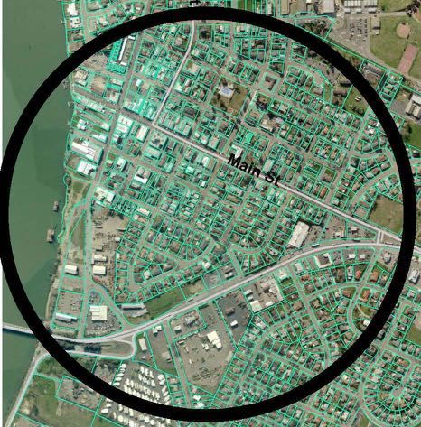
Appropriate cycle parking standards are important to ensure that convenient, easily used, and secure problem is a resource management issue, not a supply issue. Rio
bicycle parking is available throughout Rio Vista in order to encourage people to replace some of their Vista has ample existing parking for all of its needs, and no supply
trips by bicycle. Racks should address all unique site conditions, but should be guided by the following: expansions are necessary. In fact, the amount of space dedicated
to paved surfaces such as parking, streets, and sidewalks in the
• Locate all racks to minimize obtrusions and reduction of open space heart of downtown overwhelms grassy areas and buildings.
• Orient sidewalk racks to ensure bicycles are parked parallel to the curb face and parked vehicles
• Ensure clearances from walls, trees, tree wells, news racks, doorway exits/entrances, and parked cars
Paved areas in red, buildings in black.
Source: City of Cambridge, MA
26You can also read