Rivers Arun to Adur flood and erosion management strategy 2010 2020
←
→
Page content transcription
If your browser does not render page correctly, please read the page content below
Rivers Arun to Adur
flood and erosion management strategy
2010 - 2020

                                        1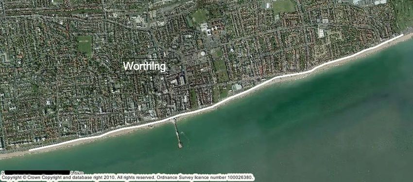
introduction
                                                                                             East End of Shoreham Beach

The Environment Agency, Arun District Council, Worthing Borough Council and Adur District Council in
partnership have undertaken a review of how we manage the coastline between the River Arun and the River
Adur, refer to Figure 1 for plan.

The final River Arun to Adur Flood and Erosion Management Strategy sets out our plan to manage flood and
erosion risks along this coastline. The final strategy was approved (April 2010) by the Environment Agency and
Arun District, Worthing Borough and Adur District Councils.

Through this management strategy, the partnership has identified ways to protect 9,800 properties that are at
risk of flooding and erosion over the next 100 years. We plan to sustain or improve all of the defences between
the River Arun and the River Adur, except for a small section of the River Adur east bank where we are
investigating the potential to create some new intertidal habitat. We have already started to work on a number
of the projects following on from the decisions made in this strategy.

This strategy takes into account:

    • a predicted increase in sea level rise due to climate change;
    • the need to evaluate options over the long term;
    • the impacts of implementation on the natural environment;
    • the Beachy Head to Selsey Bill Shoreline Management Plan;
    • the 120 responses to our public consultation carried out in 2008.

Our final strategy incorporates information and comments provided during that time. Comments from local
communities were generally supportive of the proposed option for each frontage, although there were some
concerns regarding the drainage of Ferring Rife and availability of funding for the works.

Views from Natural England and English Heritage on how our strategy impacts the natural environment and
archaeology in the area have also been taken into account during the development of the strategy and both
support our approved options.

                                                                                                               2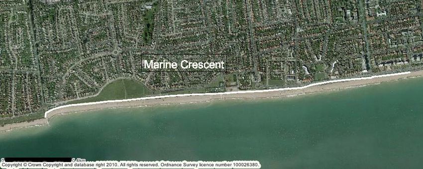
strategy area
River Adur
This strategy covers the coastline between the River Arun at Littlehampton and the River Adur at Shoreham.
This stretch of coast is characterised by shingle beaches, with a relatively low-lying coastal plain behind.
The area includes large residential and commercial developments as well as important local infrastructure, such
as roads and railway lines. At present the number of properties at risk of a 1:200 year flooding event is about
1,500. This is predicted to increase to about 7,600 over the next 100 years due to sea level rise, with an
additional 2,200 properties at risk from coastal erosion.
This strategy covers a number of areas that are environmentally important. The Adur Estuary Site of Special
Scientific Interest (SSSI), which also includes a reserve managed by the Royal Society for the Protection of Birds
(RSPB), is a nationally important site. Sites of regional importance include Shoreham Beach Site of Nature
Conservation Interest (SNCI) and Local Nature Reserve (LNR), Widewater Lagoon SNCI and LNR and Ferring
Rife SNCI.
Rising sea levels could result in loss of saltmarsh habitat over the 100 year lifetime of the strategy. We are
looking at sites locally that may be used to create replacement habitat. Work is currently underway investigating
the potential for creating mudflat and saltmarsh, floodplain grassland and reedbed habitat at upstream sites on
the River Adur, and mudflat and saltmarsh habitat on the east bank of the River Arun.
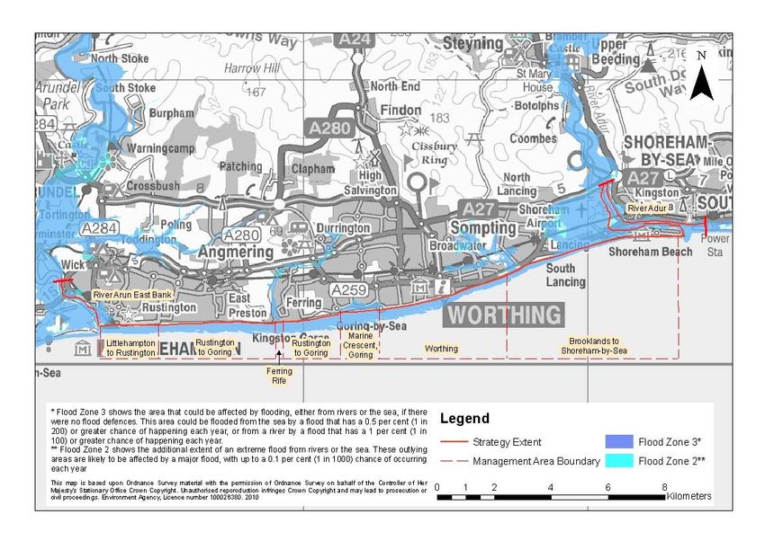
3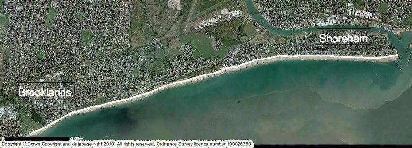
Figure 1: Rivers Arun to Adur Strategy map

                                             4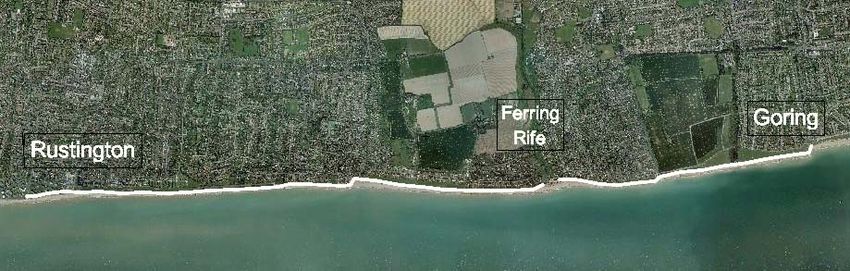
who is involved in
managing this coastline?

                                                                                                           Lancing Beach

The Operating Authorities for managing flood and erosion risk for the coastline between the Rivers Arun and
Adur are the Environment Agency, Arun District Council, Worthing Borough Council and Adur District
Council.

As Operating Authorities, we have permissive powers that allow us to protect both people and property
where economically, technically and environmentally viable and where affordable within national budgets.
Generally we have no legal duty on us to build and maintain coastal defences.

In April 2008, the Environment Agency became responsible for overseeing the management of all
flood and coastal erosion risk in England.

Under the new arrangements the Environment Agency now:
     • takes the lead for managing coastal flooding risk in England;
     • ensures that sustainable long-term Shoreline Management Plans are in place for our coastline and
       approves them on behalf of Department for the Environment, Food and Rural Affairs (Defra). This
       coastline is covered by the Beachy Head to Selsey Bill Shoreline Management Plan;
     • allocates flood and coastal erosion risk management capital funding.

Under current policies the local authorities will continue to deliver their coastal erosion role as before, but
now under the Environment Agency’s overarching management. The Environment Agency and local
authorities are working hard to ensure that we deliver this new way of working in a true partnership
approach.

We work with other organisations, such as Natural England, to understand what effect our strategy will have
on the local environment.
                                                                                                                  5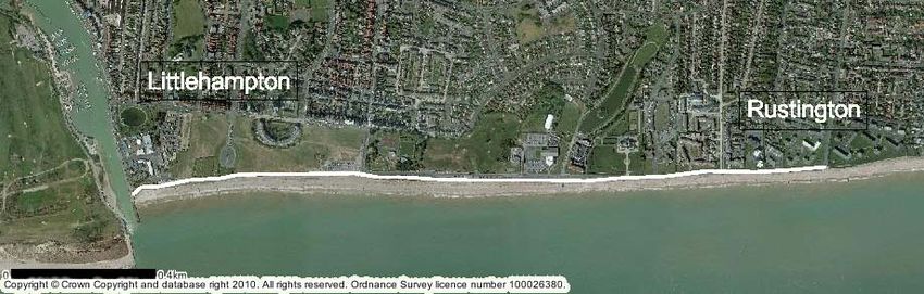
strategy development
    For each frontage we have assessed flood and erosion risk management options, using technical,
    economic, social and environmental criteria. For each option we have considered:

         •   how it would address flood and erosion risk to people and properties;
         •   whether it would work for the short, medium or long term given the effect of sea level rise;
         •   the cost of the option and the value of damage avoided by providing such defences;
         •   how it would be built or maintained;
         •   how it would impact on people who live in, work in and visit the area;
         •   the effect it would have on the natural environment.

      Management Option          Description

                                 Let nature take its course – no work will be carried out to maintain or repair
      No active intervention
                                 defences, allowing them to deteriorate over time.

                                 Maintain – defences are maintained as they are but as sea levels rise, flood
                                 and erosion risk increases over time.
      Active intervention to
                                 Sustain – defences are raised and strengthened keeping the levels of flood
      hold the line –
                                 and erosion risk the same as now.
      by maintain, sustain or
      improve
                                 Improve – defences are improved to increase the standard of protection over
                                 time, beyond the requirements of rising sea levels.

                                 Improve coastal stability by managing and moving coastal defences to a more
       Managed realignment       sustainable location further inland.

                                 Managing complex areas by monitoring changes and acting on them in a
      Adaptive management        planned but flexible way, increasing our understanding over time.

Our final option for each of the frontages is generally to hold the line by improving or sustaining the current
standard of defence against flood and erosion.

The options were finalised after widespread consultation and review by local authorities, the
Environment Agency and Defra. Now that they are approved, the schemes will need to qualify for national
funding. They will be ranked against other nationally submitted proposals for flood and erosion risk management
and funding will be allocated on a priority basis.

We want communities to help in the design of flood risk management schemes to maximise the local benefits
and we will seek feedback again when we are in a position to develop the options further.

                                                                                                                  6
what we plan to do – river
   frontages
 Implementation Plan
                              Approved strategy                 Planned work
  Frontage                                                                                           Date
                                   option                    (subject to funding)

                                                    Raise defences where required            2010 – 2014*
                             Hold the line –
  River Arun East Bank
                             Improve                Replace steel sheet piling at end of
                                                                                             2060
                                                    residual life
                                                    Raise defences of west bank tidal
                                                                                             2014*
                                                    walls where required

                             Hold the               Habitat creation works                   2016
  River Adur West Bank       line – Improve
                                                    Raise sections of wall not requiring
                                                                                             2031 and 2036
                                                    raising in year two
                                                    Tidal barrier (or further defence
                                                                                             2060+
                                                    raising)

                                                    Raise Defences                           2030
                             Hold the line –
                             Improve (north)        Tidal barrier (or further defence
                                                                                             2060+
                                                    raising)

  River Adur East Bank                              Raise defences                           2020
                             Hold the line –
                             Sustain (central)
                                                    Raise defences                           2060

                             No active
                                                    n/a                                      n/a
                             intervention (east)

*These schemes are in the Environment Agency’s Medium Term Plan (five year programme of Flood and
Coastal Erosion Schemes 2010/2011 -2014/2015), published in April 2010.

For these schemes we will produce a Project Appraisal Report which will look in detail at the costs and benefits
and how to protect as many properties as we can economically justify. It will determine what materials to build
any new defences from, what they will look like, the exact alignment and how high they need to be. This strategy
does not guarantee funding for these planned works.

Please see page 14 to read about how funding is allocated.

                                                                                                              7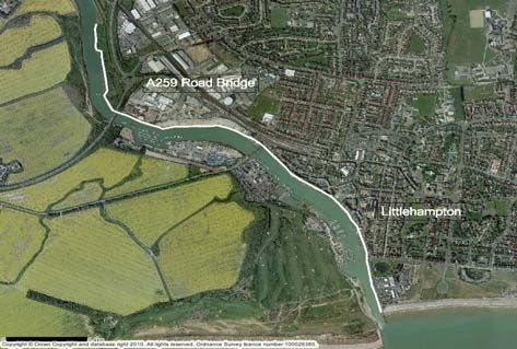
what we plan to do – coastal
frontages

                                                      Planned work
    Frontage     Approved strategy option                                            Date
                                                   (subject to funding)
                                            Beach nourishment, groynes        2045
                                            and some sea wall
                                            improvements where required.
                                            (Littlehampton)
 Littlehampton                              Beach nourishment and sea
                 Hold the line – Improve
 to Rustington                              wall construction                 2025

                                            Replace groynes at end of
                                                                              2060
                                            residual life
                                            Replace groynes at end of
                                            residual life;                    2016
 Rustington to
                 Hold the line – Sustain    Further groyne replacement
 Goring
                                            and beach nourishment,            2060
                                            construction of sea wall
                                            Replace all groynes at end of
                                                                              2035
                                            residual life;
 Ferring Rife    Hold the line – Sustain
                                            Beach nourishment                 2060

                                            Replace groynes at end of
 Marine                                                                       2021 – 2025
                                            residual life
 Crescent,       Hold the line – Sustain
 Goring                                     Beach nourishment                 2060
                                            Replace groynes at end of
                                            residual life (phased with five   2016 – 2045
 Worthing        Hold the line – Sustain    yearly intervals)
                                            Beach nourishment                 2085

 Brooklands to                              Beach nourishment and rebuild
                 Hold the line – Sustain                                      2060
 Shoreham                                   timber breastwork

                                                                                            8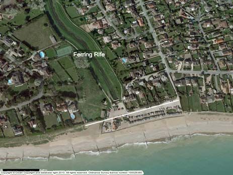
River Arun East Bank
Littlehampton is a coastal town at the mouth of the River Arun with most of the town built on the East Bank. It is a
busy seaside resort and a local commercial centre.

There are a number of flood defences along the east bank of the river including earth embankments, sheet piled
walls and a concrete apron with brick wall. The Environment Agency maintains some of the defences but the
majority are privately owned, with Littlehampton Harbour Board also responsible for a significant frontage.
As the majority of the defences currently provide a low standard of protection, they can expect to be overtopped
with increasing frequency which may eventually lead to failure and flooding as sea level rises. River Arun West
Bank is considered in the River Arun to Pagham Flood and Erosion Risk Management Strategy which can be
viewed on the Environment Agency website.

      Approved Strategy Option
      Hold the line - Improve

      Improve the current standard of protection
      by raising the level of the walls and
      embankments immediately.

      Replace the steel sheet piling at the end of
      its residual life, in approximately 50 years.

Littlehampton to Rustington
Between Littlehampton and Rustington is East Beach, a sand and shingle beach frontage. There are significant
residential and commercial properties immediately behind the beach and promenade. The coastline is protected by a
range of defences including a low concrete seawall and a shingle bank with timber groynes. The groynes immediately
adjacent to the river have reached the end of their life. However, they will not be replaced immediately as the beach
and sea wall currently provide an acceptable defence.

 Approved Strategy Option – Hold the Line - Improve
 Improve the current defences through beach nourishment, replacement of groynes at
 the end of their residual life (see table on previous page for timings) and reconstruction
 of the concrete wall, to increase protection to Littlehampton.

                                                                                                                  9
Rustington to Goring
(excluding Ferring Rife)
This frontage includes the residential areas of East Preston, Kingston and Ferring and the large area of open space and
agricultural land around Kingston Gorse. The urban areas are immediately behind a low vegetated bank at the back of the
beach. The primary defence is the shingle beach with a number of timber and rock groynes, maintained by Arun District
Council and Worthing Borough Council. They currently provide an acceptable standard of protection to this area and will
not require major investment in the immediate future.
Approved Strategy Option – Hold the line - Sustain
Sustain the current standard of protection by raising defences over time as sea level
rises.
Replace the groynes at the end of their residual life (in approximately five years), with
further groyne replacement, beach nourishment and the construction of a sea wall in
approximately 50 years.
Ferring Rife
Ferring Rife is in the low-lying area in South Ferring. It is a wide channel between two grassy embankments which
flows beneath a beachfront car park to a sea outfall. Immediately adjacent to the channel are the residential
properties of Ferring. The primary defence is a timber wall protected by a wide shingle beach. The defences are
maintained by the Environment Agency and they currently provide an acceptable standard of protection.
Approved Strategy Option
Hold the line - Sustain
Sustain the current standard of
protection by raising defences over
time as sea level rises. This will
require maintenance of existing
groynes, and replacement at the end
of their residual life in approximately
25 years, as well as beach
nourishment.
10Marine Crescent, Goring
This frontage runs from the west end of Marine Crescent in Goring to the western suburbs of Worthing and consists
of mainly residential properties. This beach is a major local attraction for fishing, sailing, jet skiing and kite surfing.
Between the beach and Marine Crescent is open space, beachfront parking and a yacht club. The primary defence is
the shingle beach which is held in place by timber and rock groynes. Particularly vulnerable areas are protected
against erosion and flooding by rock armouring and splash walls. The defences are maintained by Worthing Borough
Council and currently provide an acceptable standard of protection to this area.
Approved Strategy Option – Hold the line - Sustain
Sustain the current standard of protection by raising the defences over time as sea level
rises. This will require replacement of groynes at the end of their residual life,
in approximately 11 to 15 years, and beach nourishment.
Worthing
Worthing is a town with a large population and busy commercial centre. A wide promenade stretches along the coast
with a pier near the town centre and theatres and restaurants nearby. The primary defence between West Parade
and Brooklands Pleasure Park is a shingle beach held in place by timber and rock groynes. Particularly vulnerable
areas are protected against erosion and flooding by rock armouring and sea walls. The defences are maintained by
Worthing Borough Council and they currently provide an acceptable standard of protection to the town.
Approved Strategy Option – Hold the line - Sustain
Sustain the current standard of protection by raising these
defences over time as sea level rises. This will require ongoing
and future works to replace and improve groynes over the next 6
to 35 years, beach nourishment, protecting vulnerable sections
of the defences from erosion.
11Brooklands to Shoreham By Sea
This frontage protects residential properties with some commercial and industrial properties. It includes the
Brooklands Pleasure Park, Widewater Lagoon and Shoreham Beach. The primary defence between Brooklands
Pleasure Park and the mouth of the River Adur is a concrete sea wall with some timber sections, protected by a
shingle beach held in place by timber and rock groynes. The beach and groynes are maintained by the
Environment Agency and have recently been improved to provide an acceptable standard of protection to the local
communities.
Parts of this frontage are vulnerable to flooding from the west bank of the River Adur. Please see page 13 for our
proposals for this frontage.
Approved Strategy Options - Hold the line - Sustain
Sustain the current standard of protection by improving the
defences as sea level rises. This will require beach management
and maintenance of the existing groynes and rebuilding of the
timber breastwork in approximately 50 years.
River Adur
12River Adur
This frontage includes the east and west banks of the River Adur from the A27 southwards. The west bank is
one frontage from the A27 to the river mouth. The east bank has been divided into three sections:
• north section, A27 to footbridge;
• central section, footbridge to Kingston Beach lighthouse;
• east section, Kingston Beach lighthouse to the lock gates (does not include Shoreham Port).
Along the River Adur there are significant areas of residential and commercial property, many historic and
modern buildings, as well as public open space and agricultural land. The north section of the east bank includes
the urban area of the town and the central and eastern sections feature mainly light commercial and leisure
properties and the Port facilities. Shoreham airport and the houseboat community are on the west bank.
The banks of the River Adur include a variety of defence types including steel sheet piling, concrete walls, rock
revetments and timber groynes. The defences on the west bank are mostly maintained by the Environment
Agency and provide a very low standard of protection with the possibility of regular overtopping and defence
failure. The river, from the footbridge to upstream of the A27 is designated as a Site of Special Scientific Interest
(SSSI); there is also an RSPB reserve to the west of the footbridge.
To keep pace with predicted sea level rise, defences would need to be raised by up to 1.5m in some places over
the 100 year strategy period. An adaptive approach is therefore proposed with defence raising over the first 50
years of the strategy period. Sea level rise beyond that time would be addressed by either further defence raising
or by giving consideration to the construction of a tidal barrier in the latter half of the strategy. This approach will
be kept under review as sea level rise predictions are confirmed or amended.
Approved Strategy Options
Improve the defences on the west bank
and east bank (north section only) to
provide a higher standard of
protection.
Sustain the east bank, central section,
by raising the existing defences to take
account of sea level rise while
providing the same standard of
protection.
There will be no active intervention for
the east bank, east section, due to the
current low flood risk in this area.
13funding for flood and
erosion risk management
Implementing this flood and erosion risk management strategy depends on the availability of funding from
central government.
Funding is allocated nationally and priority given to schemes protecting large numbers of houses, where
flooding and erosion are an immediate risk and likely to cause significant damage. In this document, we set
out how we intend to manage flood and erosion risk over the next 100 years. In these cases, exposure to
flood or erosion risk could increase over time in the absence of investment.
To help us to do more to manage flood and coastal erosion risks we will look for contributions from private,
public or voluntary organisations or communities who will benefit the most from our work. By reducing our
costs, a contribution will help to improve the chances of the work happening at an earlier date than would
otherwise have been possible. In addition, a contribution could fund additional work to increase the standard
of protection over those which we would otherwise have delivered.
Sources of contributions may include infrastructure levies, Section 106 funding under the Town and
Planning Act (1990) and precepts at parish council level, as well as contributions from local commercial
interests which would benefit directly from a reduction in flood risk.
Worthing Beach
14where can I find out more?
This final strategy and the Strategic Environmental Assessment Post Adoption Statement were published
in November 2010 and can be downloaded from the Environment Agency website. www.environment-
agency.gov.uk/yourenv/consultations/
You can keep up to date with the Environment Agency's progress on implementing this strategy on our
website:
www.environment-agency.gov.uk/homeandleisure/floods and clicking on “flood schemes and strategies in
your area”.
You can also access these documents and find out about progress on implementing the strategy from the
partners websites:
www.arun.gov.uk and follow the links to Engineers (under the A to Z of services) and then Coast Protection
www.worthing.gov.uk
www.adur.gov.uk
River Arun (north of the A259 bridge)
15Would you like to find out more about the Environment Agency?
Then call us on 08708 506 506 (Mon – Fri 8-6)
email enquiries@environment-agency.gov.uk
or visit our website
www.environment-agency.gov.uk
incident hotline 0800 80 70 60 (24 hrs)
floodline 0845 988 1188
Would you like to find out more about Arun District Council?
Then call us on 01903 737500
email info@arun.gov.uk
or visit our website
www.arun.gov.uk
Would you like to find out more about Adur District Council?
Then call us on 01273 263000
email info@adur.gov.uk
or visit our website
www.adur.gov.uk
Would you like to find out more about Worthing Borough Council?
Then call us on 01903 239999
email enquiries@worthing.gov.uk
or visit our website
www.worthing.gov.uk
16You can also read