THE SOURCE OF THE USK WALK
←
→
Page content transcription
If your browser does not render page correctly, please read the page content below
THE SOURCE OF THE USK WALK
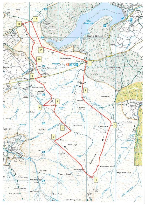
Overall distance: 16 kilometres or 10 miles
Altitudinal range: 320 metres (car park) - 615 metres (foot of Fan Foel)
Ground conditions: mostly firm and dry but with some poorly-drained areas,
particularly to the east of the Usk and Tarw.
Map: OS OLM sheet (1:25000 scale) is recommended and it is this map which is
referred to in this guide. Although there are many visible landscape features to
help navigate the route, hand-held GPS is a useful aid in open moorland.
Footpaths: This route is only incidentally related to footpaths shown on the map.
Site References: Numbers in brackets refer to site record numbers (NPRN =
National Primary Record Number). These references allow site details to be
accessed through the Commission’s on-line database www.coflein.gov.uk
This walk takes in the upper reaches of the River Usk as far as its source (below
the cliffs of Fan Brycheiniog and Bannau Sir Gaer), the far eastern side of
Mynydd Du and the southern extent of Mynydd Myddfai. Sites of the prehistoric,
Roman, medieval & later periods can be seen along this route.
On the A40 Llandovery-Brecon road, take the minor road west from Trecastell to
Cross Inn and Llanddeusant. There is a parking and picnic area at Pont’ar Wysg,
in forestry just off this road, on the left at SN82002715.
1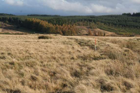
2
On leaving the carpark turn left out of the forestry and left again onto open
moorland. Follow a southerly course to cross a minor stream at SN 81912686.
Continue southwards across soft boggy ground to SN81822613, a crossing point
on Nant Tarw.
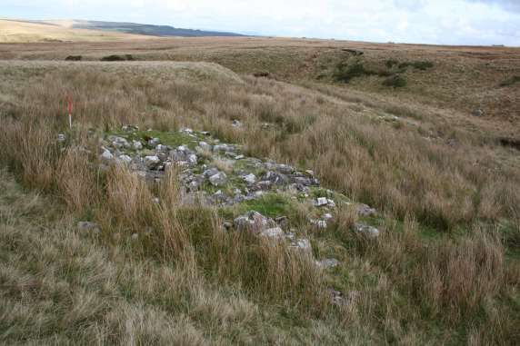
Follow the line of the stream and after a short distance will be seen a grey spread
of stones, at SN81992587 (Fig.1).
Fig.1 Ruined round cairn above Nant Tarw, looking east.
(NPRN 304782 DS2010_955_003)
This ruined burial cairn is one element in a complex of prehistoric burial and
religious monuments, of later Neolithic and Early Bronze Age date (the third and
early second millennia BC), the most prominent of which are two stone circles.
Both are shown on the map.
3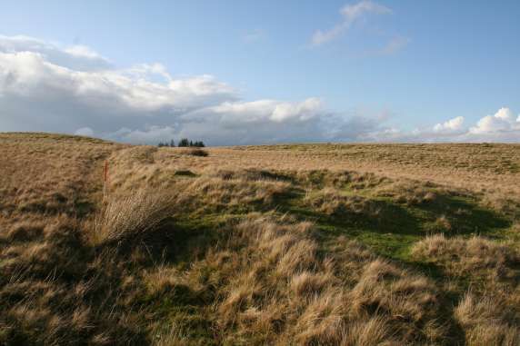
Fig. 2 Western stone circle above Nant Tarw, looking south.
                          (NPRN 104. DS2010_956_001)

The westernmost of the pair (Fig.2) at SN81872584 lies on a local rise. At least
14 stones are visible though it is likely that others lie concealed beneath turf. A
large slab of rock to the immediate west may be an outlying feature of the
monument.

                                          4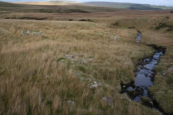
Fig. 3 Stone circle above Nant Tarw, easternmost of a pair, looking north, figure at
   centre. Cairn in Fig.1 visible in the background. (NPRN 104 DS2010_957_001)

Its neighbour (Fig.3, above) lies at a slightly lower level to the south-east, at
SN81972579, but is less well defined. Again, 14 stones are visible, some of
which are perhaps naturally set boulders and, like its neighbour, others may lie
concealed beneath peat.

                                           5
Fig. 4 Stone row near the Nant Tarw circles, looking north. Scale: 1m.
                        (NPRN 104288 DS2010_958_001)

To the north-west of the circles, at SN81762588, is a large stone which may once
have been upright (Fig.4). Two shorter stones adjacent to it suggest a former
alignment. The combination of one large and two small uprights in this way is
also found at a site in the upper Tawe valley, at Maen Mawr, likewise associated
with a stone circle.

                                          6
Fig. 5 Derelict sheepfold on the south bank of Nant Tarw, looking north-east.
                          (NPRN 412393 DS2010_959_001)

To continue the route from the circles take a south-easterly direction, above Nant
Tarw, holding to the upper, generally drier, slopes for about one kilometre.
Below, on the south bank of the Tarw can be a seen a large, derelict sheepfold,
portrayed on the map at SN82852519 (Fig.5). This multi-cellular fold, servicing
the needs of commoners with holdings around the moorland fringe, is a
testimony to the importance of sheep husbandry in the Great Forest, particularly
from the later eighteenth century onwards.

                                          7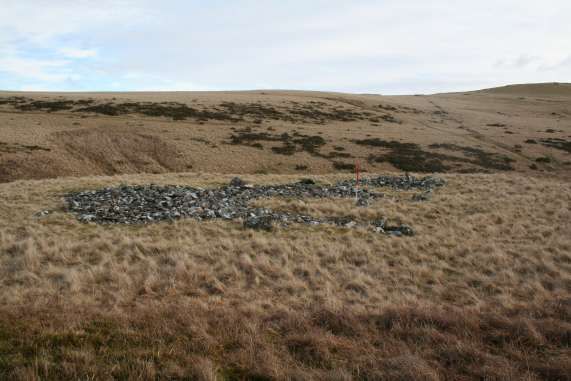
Fig. 6 Burial Cairn on Garn Las.
                        (NPRN 84436 DS2010_961_001)

To the immediate south of this fold, on the higher ground of Garn Las, lie two
Bronze Age burial cairns. The northernmost (Fig. 6), at SN82872500, has been
disturbed like most such monuments. A small marker cairn has been piled up
within a central robbing hollow.

                                       8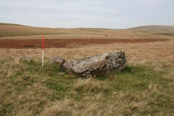
Fig. 7 Ruined burial cairn on Garn Las. Scale: 1m.
                         (NPRN 84457 DS2010_960_001)

One of a pair, its neighbour lies about 200m to the south-south-west at
SN82852519 (Fig.7). This one is clearly the more disturbed of the two, the cairn
mass having been spread about a good deal, probably in the course of robbing.

Take a southerly course from the cairn to meet a narrow trail which follows a
south-south-west direction towards the looming escarpment of the Fans.

                                         9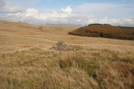
Fig. 8 Eroded blanket peat below the Fans escarpment, looking south-west.

As the altitude passes 500 metres, the erosion of blanket peat is very clear, as
shown here with peat ‘hags’ now dominating the local terrain.

Continue south, along braided pathways, towards the foot of the escarpment.

                                        10
Fig. 9 Site of supposed stone circle,in an arrangement of boulders looking north.
Scale: 1m (NPRN 84463)
As the base of the escarpment is approached, the site of a stone circle is shown
on the map, at SN82232312 (84463). This circle is quite unlike those already
seen. It is indistinct and appears to be formed by low, naturally-set boulders, the
trail passing through them. Indeed, this is a doubtful example of a stone
circle, despite its recognition on the map, and it is probably no more than a
fortuitous arrangement of stones and boulders.
The trail continues towards the escarpment. A little to the south of the ‘circle’ a
narrow trail branches off downhill to the north west. Follow this, past the source
of the River Usk, for about two kilometres into the saddle between the higher
ground of Waun Lwyd and Bryn Mawr. On this lower area, above the head of a
stream called Sychnant, lies another circle, at SN80862440 (92909).
11Fig. 10 Sychnant (Bannau Sir Gaer) stone circle looking west.
(NPRN 92909 DS2010_962_001)
Similar in form and scale to those near Nant Tarw, this one displays ten or eleven
stones. It has clearly been disturbed so other stones may have been removed, or
else become buried beneath peat.
12Fig. 11 Settlement remains in the cutting of the Usk, grey spreads of stone representing
the foundations of former buildings. (NPRN 84465 DS2010_963_001)
From the circle follow a north-easterly line towards the west bank of the Usk. At
around SN 814248 are the remains of a settlement, one of several along the river
bank (Fig. 11).
The stony foundations of several structures are strung out over a distance of
about 70 metres along the river bank, sheltered against the scarp of the river
cutting, tucked in against its side. Mostly overgrown with rushes, they appear
from a distance as no more than patches of stone.
13Fig. 12 The remains of a longhut in the cutting of the river.
(NPRN 301682 DS2010_964_001)
The clearest feature in the group is a ‘longhut’, the foundations of a linear
building, at SN81412482, above, but there are also traces of other buildings
including animal pens of rectangular and circular shape. Perishable wood and/or
turf would have formed much of these structures.
Settlements like these are found widely in these uplands. Most probably date
from the last 500 years or so and are usually described as having a seasonal
function, related to summer pasturing and dairying by lowland farmers. However,
this is largely an assumption as there is no direct evidence that these particular
buildings were used in this way.
Follow the river downstream to its confluence with Nant Cwmothlwm, at
SN 81272512. There is a ford at SN81212507. Nearby, on either side of the
confluence are some rectangular structures and spreads of rubble which may be
former structures (84451 & 408437- 8). Similar buildings can be found all along
this side of the river, as far as the parking area. Curiously, they are absent from
the opposite bank. The reasons for this are unclear. The river is an ancient (and
indeed a modern) administrative boundary. On the other side lay the Great
Forest, a hunting preserve of the medieval lordship of Brecon. This may have
imposed restrictions on activities by tenants of the lordship giving rise to different
land use practices, though this is unlikely to have been the only factor.
14At this point walkers may wish to follow the river back to the car park. Otherwise,
take a north-west direction over the shoulder of Bryn Elen; a trail a short distance
to the south-west avoids the wet ground of Mawnbwll Lloi.
Fig. 13 The stony spread of a small mound, believed to be a burial cairn, located on a
local patch of rising ground on Bryn Elen. Scale: 1m.
(NPRN 408435 DS2010_965_001)
On Bryn Elen itself (Fig. 13) lies a small Bronze Age burial mound at
SN80922562. Turning to face the rising, curving escarpment this location gives
the impression, at least on the south, of an ‘arena-like’ setting.
Continue along the trail until a ford the Afon Llechach is reached at
SN80472563. A tributary flowing into the river from the south west is called Nant
Ty-bach. As the name suggests, there are small houses along the banks of the
stream and their faint traces can still be seen: a platform on its north bank at
SN80462562, a terrace cut into rising ground which once supported a building
probably of wood and/or turves (84437); opposite, at SN80472559, the grassy
foundations of a longhut (84438); and another at SN80442251 (84439). Other,
more ephemeral stuctures lie further upstream. The stream-name appears on the
earliest OS mapping but how and when the name was first used, and the function
of the buildings, are unknown.
15Fig. 14 Grassy burial mound visible as a low tump on the centre skyline.
(NPRN 408436 DS2010_966_001)
From the ford, take the trail to the north-east. The track becomes braided and
indistinct but stay parallel with the shallow stream valley to the north and cross it
at SN80732589. Rising up out of the valley, to the right of the track (on the near
skyline) is another prehistoric burial mound, at SN80762597 (above). It stands
out on the skyline as a turf-covered stony mound about 7 metres across but with
no distinguishing features.
Continue along the track, maintaining a north-westerly direction (the trail
becomes braided and trends to the west). About 500 metres from the ford the
trail passes what appears to be an old field bank, at SN80492634. This is
actually the perimeter bank of a Roman camp known as Arhosfa’r Garreg-lwyd
(Fig.15), and is shown on the OS map. The camp, a four-sided playing card
shaped enclosure of 18 hectares, was built by Roman legionaries for protection
from attack during overnight stops whilst on campaign. Each soldier carried a
wooden stake which was set into the bank for added defence. This camp
probably dates from the military campaigns of the first and second centuries AD.
16Fig. 15 Roman marching camp at Arhosfa’r Garreg-lwyd. North perimeter bank adjacent
to road, looking west. Scales: 1m. (NPRN 84422 DS2010_967_001)
The nearby Trecastle road can now be followed back eastwards to the car park,
if walkers wish to finish here.
Otherwise, to continue this walk onto Mynydd Myddfai, follow the road east for
about 250 metres, to SN80442663, where there is a trail to the north. Follow this
downhill into the valley of the Clydach, cross the ford at SN80262699 and
continue in a north-west direction along the track, now a terraced formation, to a
left ‘kink’ at SN80212722.
Above this, to the north-east, on the right, lies a well-preserved building platform,
at SN80232722 (Fig.16), a terrace cut into the rising slope which once supported
a building of perishable materials. These are usually ascribed a date in the
medieval period, say 12th-14th centuries, but could be later.
17Fig. 16 A level area cut into rising ground to support a building. Scale: 1m at rear end of
terrace. (NPRN 84445 DS2010_968_001)
Continue up the track and past a sharp bend in it. To the right, on the east side,
can be seen, under favourable light conditions, low cultivation ridges aligned
towards the track, at SN801275 (Fig.17).
On the ground these ridges are faint but aerial photographs show that parts of
southern Myddfai were once extensively ploughed. The date is unknown but
several contexts are possible. High altitude cultivation did occur during the
medieval period, here possibly associated with a nearby monastic grange, now
beneath the Usk Reservoir, perhaps instead during the Napoleonic wars, and
even during the wartime emergencies of the twentieth century. The ridges are not
contained within any obvious enclosure and it is not clear if they are associated
with the platform just visited.
18Fig. 17. Cultivation ridges adjacent to trackway on Fedw Fawr, looking north-east.
Scale: 1m. (NPRN 84443 DI2010_969_001)
The track descends into a valley. To the immediate north, just off the track, is a
longhut sheltered in the lea of an outcrop exposure, at SN80072773 (84444).
Continue down the trail to the valley bottom. At the point where it turns sharply
west it is intersected by a bank, flanked on its east side by a track (Fig.18).
19Fig. 18 Boundary bank of abandoned intake of moorland, looking north-west. Scale: 1m.
(NPRN 84266 DS2010_970_001)
This follows one side of an unmapped field enclosure which represents an
abandoned intake of moorland, above Pentregronw, but subsequently
abandoned. Enclosures like these, extending the scope of farming onto higher
ground, were often made when economic conditions justified the effort before
changing circumstances prompted a retreat. At SN79882773 the bank joins the
perimeter of a second intake enclosure (above), a much more substantial bank
and shown on the map. The track cuts through it. Ignore this and follow the
unmarked trail along the north (on the right) side the second enclosure bank for
about 300 metres. Just inside the enclosure is another platform, below at
SN79742848 (Fig. 19), similar to the one seen earlier.
20Fig. 19 Building platform seen from the south; 1m scale marks the upper end of the
terrace, the stones on the left mark the lower end. (NPRN 84263 DS2010_971_001)
A group of several small cairns lies to the south of it, probably resulting from
stone clearance during improvement of the enclosure (84265) in which air photos
have revealed cultivation ridges. It is not certain that the platform is of the same
date as the cultivation and enclosure features.
From the enclosure bank above the platform follow an easterly line for about 250
metres onto slightly higher ground overlooking the Usk Reservoir and the
southern slopes of Mynydd Myddfai.
21Fig.20 Heavily disturbed burial cairn on the southern slopes of Mynydd Myddfai.
Scale: 1m. (NPRN 84424 DS2010_972_001)
Here, there is a robbed out burial mound at SN80042856 (Fig.20) one of many
prehistoric burial and religious monuments on Mynydd Myddfai, their distribution
extending into nearby forestry.
Two to three kilometres to the north-east (outside the scope of this walk) is the
route taken by the LNG (Liquefied Natural Gas) pipeline. Excavations during
recent development work revealed much archaeology concealed beneath deep
peat deposits, including later prehistoric settlement sites.
The cairn overlooks, on the east, Pant Meddygon (= dingle of the physicians).
Local traditions of herbal medicine go back at least to the Medieval period when
the tenants of the manor of Myddfai were required to supply a doctor to the lord
of Llandovery. The place-name alludes to this and suggests the local flora was
once very diverse, in contrast to the acid heath and grassland that now
dominates today.
22Fig. 21 Possible cultivation ridges on Fedw Fawr. (NPRN 84443 DS2010_969_002)
From the cairn take a south-south-east course towards the edge of the east-west
valley already traversed. Looking south across the valley it may be possible to
see cultivation ridges down the north-west side of Fedw Fawr, aligned roughly
north west-south east (Fig. 21).
23Cross the valley onto Fedw Fawr and take an east course towards the forestry
boundary. At around SN813275, on Bryn Pwllgerwn, can be seen a complex of
intersecting banks (Fig.22), some shown on the map.
Fig. 22 Conjunction of moorland intake banks. Scale: 1m.
(NPRN 84426 DS2010_973_001)
These boundaries represent successive intakes of moorland, each one
abandoned in turn, alternating in and out of use over the last few centuries. Air
photos show that the innermost enclosure, closest to the forestry, contains faint
traces of cultivation.
24Fig. 23 Southernmost extent of bank looking eastwards. Scale: 1m.
(NPRN 84426 DS2010_973_002)
The perimeter of the outermost enclosure, not shown on the map, radiates
outwards from the angular bank that is shown (Fig.23). It extends as far as a
prehistoric burial mound, on the spine of the ridge, which may have been used as
a boundary marker, at SN81412738 (84428). The bank is shown, above, running
towards the mound just above centre in the picture. The cairn centre (Fig. 24)
has been hollowed out, spoil spread over the intake bank.
25Fig. 24 View of cairn with hollowed interior right of centre in the picture, the intake
boundary bank receding from it, looking west.Scale: 1m, in bank outer ditch.
(NPRN 84428 DS2010_974_001)
From here the carpark is located about 600m to the south-east.
26You can also read