Rock Collecting, Land Status, & Mining Claims: An Overview
←
→
Page content transcription
If your browser does not render page correctly, please read the page content below

Rock Collecting,
    Land Status, &
    Mining Claims: An
    Overview
    Lucia M. Patterson MS CPG, Nevada Division of Minerals
    Reno Gem & Mineral Society
    September 1st 2021

Good evening and thank you for inviting me to talk to you about rock collecting, land
status, and mining claims. This presentation will cover a fair amount of material, but it is
meant to be a general overview with links to more detailed information if one would like to
pursue it. This presentation is available on our main website at www.minerals.nv.gov
under the recent presentations hyperlink to the right of the picture carousel.

                                                                                               1
=

                                               Geologist With the Nevada Division of Minerals (7 years)
                                               Graduated from UNR with a Masters in Economic (Mining)
                                               geology
                                               Worked in exploration geology for 6 years

My name is Lucia. I am a geologist with the Nevada Division of Minerals. I obtained my
bachelors in science majoring in Geology at California State University Chico and my
Masters degree in economic geology from University of Nevada Reno. I worked as an
exploration geologist here in Nevada for six years before taking by current position with the
division, where I have been for the last seven years.

                                                                                                          2
I would like to briefly introduce our open data site which we will be utilizing later. This is
the homepage of our open data site equipped with our mission statement and disclaimer.
The URL and QR code for our open data site can be found at the top of this screen.
Scrolling down…

                                                                                                 3
We come to several icons which represent links to our various pages. There is lots of
information on this site, so much that it has a presentation of its own equipped with
demonstrations on how to work the interactive maps. This presentation can be found at
the link which is being pointed out by the red arrow or by scanning the QR code shown on
the screen. For our purposes, this presentation will mostly focus on the Active Mining
Claims of Nevada page. We will briefly visit the education and outreach page in a moment.
If we scroll down…

                                                                                            4
You will come to the bottom of the home page which has links to other sources of
information regarding geology, exploration, and mining in Nevada.

Now we will scroll back up to the pages available within the open data site.

                                                                                   5
Education & Outreach

And as promised we will briefly visit the education and outreach page.

                                                                            6
Here is our education and outreach page, we can see a map which shows all active mines
and energy producers in Nevada. Most maps on our website are interactive, and if the user
clicks on a point a pop‐up will render yielding information about the feature, in this case
the pop‐up is giving information on the active mine we clicked on.

Scrolling down…

                                                                                              7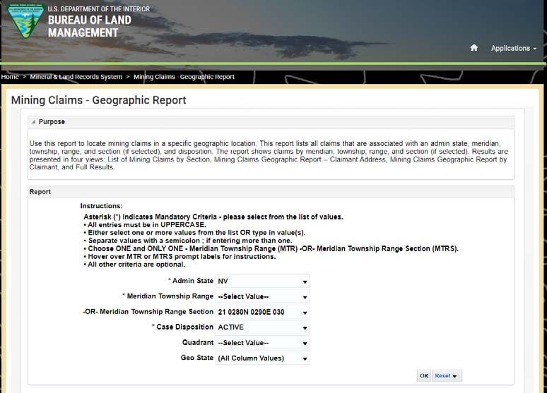
We come to a listing of educational videos the employees at NDOM have been made to
assist in distance learning. There are summaries for all videos along with links to classroom
activities and more.

We have several videos covering various topics, and if a video request were to be made for
something not presented here on this page…yours truly is typically up to the task. We can
see here we have videos covering geologic history, evolution, and the geologic history of
Nevada, the basics of mineral identification, the rock cycle, mining in Nevada, the geologic
history and ore deposits of Nevada…on a brownie, ore deposits, cupcake core drilling and
more. If we scroll towards the bottom of the page

                                                                                                8
We will find a series of story maps. The first one displayed is an informational story map on
NDOM’s abandoned mine lands program. Other story maps are available which cover
geology, and tours that are taken during our teachers workshops we help to put on along
with the Nevada Mining Association twice a year. One workshop takes place in Northern
Nevada and one in Southern Nevada. The teachers' workshops are free to attend. Ok, we
will revisit the open data site when we review land research…but before we dive into that
topic lets begin with what CAN be collected on public lands.

                                                                                                9
What you can collect:                            What you cannot collect:
      Gemstones and common rock specimens             Saleable Minerals, such as sand, gravel,
      may be collected for PRIVATE/PERSONAL use       cinders, topsoil and other common varieties
      and will not be utilized for commercial
      purposes or bartered to commercial dealers      of minerals (they must be purchased by prior
      (Commercial production of common rocks on       arrangement with the BLM)
      an unclaimed site requires a permit)

      Common invertebrate fossils such as plants,     Vertebrate fossils such as dinosaurs,
      mollusks and trilobites (in reasonable          mammals, fishes and reptiles, and
      quantities, may not be bartered or sold)        uncommon invertebrate fossils

      Petrified Wood 25lbs + 1 piece not to exceed
      250 pounds/calendar year (may not be            Cave resources including plant, animal and
      collected for commercial purposes, bartered     geologic features
      or sold)

So, what can you collect. Well, you can collect gemstones, common rock varieties,
invertebrate fossils, and petrified wood for private or personal usage if they are not utilized
for commercial purposes, used for trade, or bartered.

The only item that has limits on the amount one can collect for personal usage is petrified
wood of which you can only collect 25 pounds plus one piece per day not to exceed 250
pounds per year.

What you can't collect consists of any saleable minerals such as sand gravel, cinders, topsoil
and other common varieties of minerals, vertebrate fossils, uncommon invertebrate fossils,
and cave resources including plant animal and geologic features.

                                                                                                     10
According to the Code of Federal Regulations section 8365.1‐5 “Except on developed
recreation sites and areas, or where otherwise prohibited and posted, it is permissible to
collect from public lands reasonable amounts of the following for noncommercial
purposes: Nonrenewable resources such as rock and mineral specimens, common
invertebrate and common plant fossils, and semiprecious gemstones. “ And, as previously
discussed, you may collect a certain amount of petrified wood.
11You can collect in: You can not collect in:
BLM Lands – without valid mining claims Private Lands – Unless you have permission
National or State Parks
USFS lands – without valid mining claims State Lands – technically private, contact state lands
Within the boundary of valid mining claims
Department of Defense Lands – unless posted otherwise
Developed recreation sites and areas
Department of Energy – unless posted otherwise Department of Defense – if posted no trespassing
Indian Reservations without permission from tribal
authorities
ACEC – unless posted other wise
Department of Energy Lands – if posted no trespassing
US Fish & Wildlife Lands – unless posted otherwise (most are ACEC – if posted no trespassing or no collecting
closed)
US Fish & Wildlife Lands –no collecting
Bureau of Reclamation Lands – unless posted otherwise Bureau of Reclamation Lands – if posted no collecting
Wilderness & Wilderness Study Areas – if posted no collecting
Wilderness & Wilderness Study Areas – unless posted National Conservation Areas – if posted no collecting
otherwise
National Monuments
National Conservation Areas – unless posted otherwise National Historic Sites
National Wildlife Refuges
Do not trespass ‐ If in doubt call the proper land management agency OR consult with a landman
So, what this means. You can collect reasonable amounts of gemstones, common rock
varieties, invertebrate fossils, common plant fossils, and petrified wood for private or
personal usage on all federally managed lands unless collecting is otherwise prohibited and
posted. If you can’t go on department of energy or department of defense lands…it should
be posted no trespassing. Within the boundaries of ACEC’s or areas of Critical
Environmental concern you may or may not be able to collect. For example, if a site has
been set aside to preserve a certain suite of fossils…you will not be able to collect there.
But say the site was set aside for protection of a species of lizard…well you can probably
still collect a reasonable amount of specimens there…if you can’t…it should be posted
otherwise.
Within the boundary of most US Fish and Wildlife lands you are not permitted to collect.
There are exceptions…but if you REALLY needed to go rock collecting on their land…I would
contact them. And on that note…if you really needed to go collect on any public lands but
you are not quite sure if you can…I would reach out to the administrative agency and ask
the question. Better to be once safe than twice sorry.
You CANNOT collect on private or state lands without the permission of the landowner or
claimant. You CANNOT collect within the boundary of an active mining claim with out the
claimant's permission. You cannot collect in developed recreation sites and areas or within
12the boundary of areas that are clearly posted no trespassing. You CANNOT collect on Indian
Reservation lands or Bureau of Indian Affairs Land without permission from tribal authorities.
You also cannot collect within the boundaries of National Monuments, National Historic
Sites, or National Wildlife Refuges.
Again…if in doubt call the surface management agency or landowner, seek advice from some
one who looks at this stuff frequently, or if it is really complicated either seek out a land man
or just don’t collect there.
12Magnitude of the
Problem: BAD AIR
For every mine, adit, shaft, or
prospect symbol on a October 1999‐Female
topographic map there are 2‐ juvenile (11) killed in a
3 more waiting to be found! 120 ft. deep mine shaft
near Beatty
There is an estimated
200,000‐300,000 points to June 1999‐Male
log. NDOM has currently juvenile (11) drowned
logged over 60,000 of these swimming in open
points. pit lake
May 2011‐Adult
male (28) suffered
May‐2009 Dog fell down fatal
inclined shaft, rescued 10 injuries after falling
days later 190
feet down a shaft
Story Map
Just as a quick reminder….it is never safe to go into an abandoned mine. No matter how
many precautions are taken, the dangers associated with abandoned mines such as bad air
or dangerous gasses, mine collapse, rotten timbers, becoming lost and disoriented,
explosives and chemicals, and the lack of a guaranteed rescue can lead to a deadly
situation in only a matter of minutes. There is nothing inside abandoned mines that is
worth as much as your life. STAY OUT, STAY ALIVE.
13Leasable – minerals that have been removed from acquisition by
“location” under the 1872 mining law (oil, gas, oil shale, coal, geothermal
resources, potash, sodium, native asphalt, semisolid bitumen, bituminous
rock, phosphate, chlorides, sulfates, certain carbonates, borates, silicates
or nitrates of potassium or sodium and related products, and Sulphur).
Salable – common varieties of sand, stone, gravel, pumice, pumicite,
cinders, and clay that do not possess any specific property giving them a
distinct or special value (excluding block pumice, limestone suitable for the
production of cement, metallurgical grade limestone, chemical‐grade
limestone, limestone suitable as a soil additive and gypsum)
Locatable or Hard Rock Minerals – includes metallic (gold, silver,
cinnabar, lead, copper, tin, zinc, nickel uranium, etc.) nonmetallic minerals
(fluorspar, mica, certain limestones and gypsum, tantalum, heavy minerals
in placer form, and gemstones along with certain uncommon varieties)
I know it would seem like now would be the time to answer the question, “well how do I
figure land status out?”. We will answer that question, but I understand that there are
some members who may be interested in staking some mining claims and in order to do
that you also have to figure out which lands you can stake claims on. For both mineral
collecting and claim staking we are answering similar land status questions, so will answer
both questions together in a moment.
But first, Let's talk about the different kinds of minerals. To understand where these came
from let's take a little trip back in time. The 1872 mining law was put in place to “promote
the Development of the mining resources of the United States”. The lands mineral riches
would be made available to every citizen, and the efforts of each would be protected only
to the extent that a discovery was made pursued, and even then, within limits designed to
prevent monopolization of large deposits. Under the 1872 general mining law, the law that
still oversees mining claims and mining today, a United States citizen could go out, stake a
claim and would have the exclusive right to use and possess the property for mining
purposes and to develop and sell the mining products from the same free of any royalty to
the federal government. And up until 1990, after discovery and at least $500 dollars worth
of labor improvements had been made upon the claim, the claimant could purchase the
land for $5 per acre for lode claims and $2.50 per acre for a placer claim. We will talk about
these different claim types in a minute.
14Mining claims over oil rich lands were being staked so quickly during the oil rush of 1909 that
they were becoming unavailable for extraction of oil for military purposes. This led to the
Minerals Leasing Act of 1920. In a nutshell the mineral leasing act of 1920 allowed the
federal government to keep control and possession of these lands, enabled drilling and
extraction of these minerals with authority granted by the federal government, enabled the
government to manage the exploitation of leasable minerals, and enabled the government
to receive compensation from the lessee for the privilege of extracting minerals on public
lands. Leasable minerals include oil, gas, oil shale, coal, geothermal resources, potash,
sodium, native asphalt, semisolid bitumen, bituminous rock, phosphate, chlorides, sulfates,
certain carbonates, borates, silicates or nitrates of potassium or sodium and related
products, and Sulphur.
It was later found in a study that the intent of the mining law was being taken advantage of.
People were staking claims over tracts of land on which the “discovery” was sand, gravel, or
even clay also known as the common mineral varieties. There aren’t a whole lot of parcels I
can think of that don’t have at least a little sand or clay. Using sand or clay as the discovery,
they would Annie up their $500 worth of labor improvements and purchase the land, land
that was located along beautiful stretches of river, or in valuable stands of timber for $2.50‐
$5 per acre. To stop this abuse of the law, the 1947 Materials Act later modified in 1955,
established that certain minerals on federal lands can only be disposed of through a contract
of sale or a free use permit. This group of minerals, the salable minerals, includes petrified
wood, common varieties of sand, stone, gravel, pumicite, cinders and clay.
So that leaves us with the locatable or hard rock minerals for which a mineral claim can be
staked, these include metallic and nonmetallic minerals, special varieties of limestones and
gypsum, tantalum, heavy minerals in placer form, gemstones, and other uncommon varieties
of rocks and minerals.
14Types of claims
Unpatented Mining Claim – a claim located on land owned by the
federal government. The owner of a valid mining claim or mill site
has the exclusive right to use and possess the property for mining
purposes and to develop and sell the mining products from the same
free of any royalty to the federal government as long as:
1. The land was open to location
2. The location is properly made
3. A discovery of a valuable mineral deposit is made
4. The claim is properly maintained through annual filings and/or payments
Patented Mining Claim – a mining claim that has been conveyed to
private ownership, it is now private property
There are two main groups of claims, Unpatented and Patented. Unpatented mining claims
are claims located on land owned by the federal government. The owner of a valid mining
claim or mill site has the exclusive right to use and possess the property for mining
purposes and to develop and sell the mining products from the same free of any royalty to
the federal government as long as:
1. The land was open to location
2. The location is properly made
3. A discovery of a valuable mineral deposit is made
4. The claim is properly maintained through annual filings and/or
payments
A patented mining claim is an unpatented mining claim that has met the requirements to
be patented and purchased from the federal government, resulting in the conversion from
federal to private ownership. There has been a moratorium on the patenting mining claims
on since 1990.
The types of claims you would stake would be unpatented mining claims.
15Types of Claims
Lode Claims – located on lands where the minerals are contained in “veins or
lodes of quartz or other rock in place”, in general it means that the deposit being
located using a lode claim has to be a mineralized zone held in place by adjoining
rock
Placer Claims – located on “all forms of deposits, excepting veins of quartz or
other rock in place, or any deposit that does not qualify as a lode
Mill Sites – nonmineral in character and are used for activities related to mining
or processing minerals
Tunnel Sites – generally only of historic interest, were used for driving a tunnel for
exploring lode deposits
So, the first choice you need to make is which type of unpatented mining claim do you
need to stake. You must choose between a lode claim or a placer claim.
A lode claim is located on lands where the minerals are contained in “veins or lodes of
quartz or other rock in place”, in general it means that the deposit being located using a
lode claim must be a mineralized zone held in place by adjoining rock.
A Placer claim is located on “all forms of deposits, excepting veins of quartz or other rock in
place, or any deposit that does not qualify as a lode
There are also Mill site and Tunnel Claims. A mill site claim is used for activities related to
mining or the processing of materials and may only be placed on lands that are nonmineral
in character. Tunnels sites aren’t utilized much, they were used for driving tunnels for
exploration of load deposits.
16Lode Claims: Placer Claims:
Erect a monument at the “point of Erect a at any point along the north
discovery” (Today, it’s more likely to be boundary of the claim
a point of convenience, like midway
along end line and set inside 10‐20’) Post in or upon the monument a Notice of
Post in or upon the monument a Notice Location which must contain:
of Location which must contain: Claim Name
Claim Name Name of locator and locator’s mailing address
Name of locator and locator’s mailing Date of Location NOL (very important, as this
address starts the clock)
Date of Location NOL (very important, as The number of feet or acres claimed
this starts the clock)
The number of linear feet claimed along the If on surveyed land the claim may be taken
length and width from the point of discovery by legal subdivision and no corner
and the general direction of the lode or vein
monuments are required
Within 60 days of posting the NOL the
boundaries of the claim must be If on unsurveyed land, within 60 days of
defined by placing valid legal posting the NOL the boundaries of the claim
monument at each corner of the claim must be defined by placing valid legal
Within 90 days of posting the NOL file monument at each corner of the claim
your claim maps and certificates of Within 90 days of posting the NOL file your
location with the BLM and the county
recorder along with all fees required by claim maps and certificates of location with
both the BLM and the county recorder along with
all fees required by both
What do you need to do to stake a claim? First, erect a location monument at the proper
location for the type of claim you intend to stake. Post the notice of location upon the
location monument which will include the claim name, name of locator and locators
mailing address, the date of location (this is VERY important as it starts the clock), and the
area claimed as noted above for each claim type. Then within 60 days of the Notice of
Location posting, the boundaries of the clam must be defined by placing a valid legal
monument at each corner of the claim UNLESS it is a placer claim located on surveyed land,
then the claim may be taken by legal subdivision and corner monuments are not required.
Within 90 days of posting the notice of location, you must file the certificates of location
and claim maps with the BLM and the county recorder in which the claim is located along
with all fees required by both.
17Lode Claims: Placer Claims:
Lode claims can be oriented in any direction and are 1500’ long and 300 feet wide on either
side of the location monument for a total claim width of 600’.
Placer claims are 20 acres each and in general follow the public land survey system or
Township, Range and Section designations which we will briefly discuss here shortly.
18Discovery (Location) Monument ‐
Lode Claim
Properly locating the Discovery Monument is Very Important!
Be sure your discovery monument IS NOT within the boundary of a preexisting, senior or
older claim. THIS WILL VOID YOUR CLAIM. Also, if you stake a claim over another person’s
claim which precedes your location, the only part of the claim you stake that is valid will be
that which is outside of the preceding claim boundary.
So, if we look at the diagram on the screen there are senior or older claims named 1‐6 in
the upper right‐hand side of the screen, and younger claims named A‐E starting in the
lower left‐hand side of the screen.
If we look at claim A, we can see the location monument signified by the LM, which is
located inside of the older number 2 claim. Therefore, claim A is void AGAIN, your location
monument CANNOT be inside the boundary of and older claim.
If we look at claims B, we can see the location monuments are not within the older claims,
so they are valid, but the portion of clam B that overlaps claims 1 and 2 are not valid.
Looking at claim C the shaded portion of the claim is valid, but the portion of claim C which
includes the discovery overlaps claim one therefore the discovery for this claim is not valid.
19Valid Legal Monuments
For A Claim:
1 ½” x 1 ½”
Blazing/marking a tree ≥ 4” diameter and ≥
3’ tall
Rock cairn (stack) ≥ 3’ tall
Stone (not in place) ≥ 6” in diameter and ≥
18” tall set on end on a mound of earth or
stone 3’ in diameter and 2.5’ tall
Metal post ≥ 2” diameter and ≥ 4’ tall set 1’
in ground; if hollow must be unperforated
and capped
Wooden post ≥ 1.5” x 1.5” ≥ 4’ tall set 1’ in
ground
Legal Monuments. I am not going to read dimensions here, but the legal monuments
include blazing's or markings on trees, rock cairns, a stone that is not in place, a metal post,
or a wooden post.
20What If’s
If you can’t sink a post because of
the ground conditions, it may be
placed in a mound of earth or
stones
If the proper placing of a monument
is impracticable or dangerous to life
or limb (example ‐ highway, road,
river, or cliff face), the monument
may be placed at the nearest point
properly marked to designate its
right place
If you can't sink a post in the ground because the ground is too hard you may place the
stake in a mound of earth or stones.
If proper placement of a monument is impracticable or dangerous to life or limb the
monument may be placed at the nearest safe spot and be properly marked to designate
the place where it should be.
21Plastic/PVC Posts Are Not Valid Monuments
Found to cause significant
number of bird, reptile, and
insect deaths
2011 legislation outlawed use
of plastic pipe for monuments
and required re‐
monumentation
To limit future deaths, plastic
pipe may be removed and laid
down
Plastic and PVC posts are not valid monuments as they cause significant bird, reptile and
insect deaths. It is never permitted to tamper with claim monuments UNLESS you see one
of these plastic or PVC posts. If you see one you may remove it out of the ground and lay it
down.
22Claim Maps and Certificates of Location
Lode Claims: Placer Claims:
Within 90 days of posting the Notice of Location, file your claim maps and certificates of location with the County Recorder
Two copies of claim Map:
• Scale of not less than 500’ to the inch and indicating location of all monuments
• Description of Township and Range, plus, if on surveyed lands, the Section and Quarter Section. Otherwise, course and
distance to a readily identifiable artificial landmark customarily shown on a map (example ‐ road intersection)
• Size of each sheet must be 8.5” x 14” (legal size) or 24” x 36”
Lode Claims: Placer Claims:
Duplicate Certificates of Location, filed with maps, must contain: Duplicate Certificates of Location, filed with maps, must
contain:
• Name of the lode or vein
• Name of the claim designating it as a placer claim.
• Name of locator and locator’s mailing address
• Name of locator(s) and mailing address(es) of
• The date of location
locator(s).
• The number of linear feet claimed along length and width from
• The date of location.
point of discovery and general direction of the lode or vein
• The number of feet or acres claimed.
• The location and description of each corner and how marked
• A statement “that the work of location consisted of making the
maps as provided in NRS 517.040.”
Maps and certificates of location must be turned in to the BLM and County within 90 days
of posting the Notice of location. If you do not do this your claim is as if it never existed.
The documents that are due, formats, scales and other information is shown on this
screen. I will not spend much time here other than to show you that it is here for future
reference.
23Lode Claim COL & Claim Map Example
Here is an example of a certificate of location and a claim map. Again, I am not going to
stay here for long, but I wanted you to know it is here for future reference.
24Yearly Maintenance Fee
Notice of Intent to Hold (FLPMA) is REQUIRED: 1. The first year when filing a Maintenance Fee Waiver, 2. when switching from paying the maintenance fee to filing a waiver,
and 3. annually for Mill and Tunnel Sites.
The notice of intent to hold or proof of labor must be filed with the BLM on or before December 30th of the CALENDAR YEAR in which the assessment year ENDS, it is
backwards looking.
DO NOT SUBMIT A NOTICE OF INTENT TO HOLD WHEN THE AFFIDAVIT OF ANNUAL ASSESSMENT WORK IS REQUIRED THIS WILL RESULT IN FORFEITURE OF YOUR CLAIM
BLM
September 1st, 2020 August 31st, 2021
2021 Assessment Year (Sept 1, 2020 – Aug 31, 2021)
2022 Assessment Year
Sept Oct Nov Dec Jan Feb Mar Apr May Jun Jul Aug Sept Oct Nov Dec
FLPMA documents are
Example ‐ Date of New Location Sept 20, 2020: due on or before Dec.
August 31st, 2021 30 for 2021
Submit Certificate of Location (for appropriate claim
Maintenance Fee must be received Assessment Year
type) AND Claim Map along with the new claim fee, or postmarked, on or before Sept 1st
processing fee, and location fee within 90 days of of each Assessment Year to cover the Notice of Intent to Hold
location. following assessment year (2022) only for Mill and Tunnel
Sites
County Within Which the Claims are Located
September 1st, 2020
August 31st, 2021
2021 Assessment Year (Sept 1, 2020 – Aug 31, 2021)
2022 Assessment Year
Sept Oct Nov Dec Jan Feb Mar Apr May Jun Jul Aug Sept Oct Nov Dec
Example ‐ Date of New Location Sept 20, 2020: Affidavit and Notice of Intent to Hold Mining
Submit Certificate of Location (for appropriate Claims, for Assessment Year 2021 and filing
claim type) AND Claim Map along with the filing fee (backward looking).
fee within 90 days after location. This covers the An affidavit made and recorded pursuant to subsection 3 or a copy thereof, certified by the county recorder, is prima facie evidence
2021 assessment year. that the owner or claimant of the mining claim intended to hold the claim from 12 p.m. on September 1 of the year before the
affidavit was made and recorded, until 11:59 a.m. on September 1 of the year that the affidavit was made and recorded.
The next two diagrams are to help individuals visualize when forms are due and to whom
they are due to. Why two diagrams you ask…well you can hold claims by paying annual
maintenance fees or by obtaining a small miner’s fee waiver. Paperwork due for holding
claims under these two methods are different so for clarity purposes, they will be
presented separately. We will discuss what a small miner’s fee waiver is in a moment.
If utilizing the maintenance fee method this would be the workflow. The top shows what
would be due to the BLM and the bottom show what will be due to the county along with
the deadlines.
An assessment year for a claim is from September 1st of one year to September 1st of the
following year. So here on September 1st of 2021 we are discussing mining claims on the
first day of Assessment year 2022. Why September 1st…well this because the fiscal year for
the BLM ends on September 30th…this gives them time to have an accurate accounting of
claims so they can close out the year.
So, if we staked a claim and posted our notice of location on September 20th of 2020, we
would have to have our corners staked by November 19th of 2020 and our certificate of
location and claim maps along with all fees filed with the BLM and the county by December
19th of 2020. We would need to have our maintenance fees for assessment year 2022
25received by the BLM or postmarked on or before September 1st of 2021…or today. If you
miss the boat…your claim is done…void…closed. As for the county, you will need to file an
affidavit and notice of intent to hold the mining claims for assessment year 2021…yes this is
backward looking and a little confusing…but that’s the way it is. The regs and statues
specifically state that The notice of intent to hold or proof of labor must be filed with the BLM
on or before December 30th of the CALENDAR YEAR in which the assessment year ENDS.
This backwards looking feature will make sense in a moment.
The next deadline is ONLY if you have a Mill or Tunnel Site and consists of documents
required by FLPMA or the Federal Land Policy and Management act of 1976. Again, it is a
Notice of intent to hold just like the county, which is backwards looking and is due to the
BLM on or before December 30 of each year.
25Small Miner Waiver
Notice of Intent to Hold (FLPMA) is REQUIRED: 1. The first year when filing a Maintenance Fee Waiver, 2. when switching from paying the maintenance fee to filing a waiver,
and 3. annually for Mill and Tunnel Sites.
The notice of intent to hold or proof of labor must be filed with the BLM on or before December 30th of the CALENDAR YEAR in which the assessment year ENDS, it is
backwards looking.
DO NOT SUBMIT A NOTICE OF INTENT TO HOLD WHEN THE AFFIDAVIT OF ANNUAL ASSESSMENT WORK IS REQUIRED THIS WILL RESULT IN FORFEITURE OF YOUR CLAIM
BLM
September 1st, 2020 August 31st, 2021
2021 Assessment Year (Sept 1, 2020 – Aug 31, 2021)
2022 Assessment Year
Sept Oct Nov Dec Jan Feb Mar Apr May Jun Jul Aug Sept Oct Nov Dec
FLPMA documents are
due on or before Dec. 30
Example ‐ Date of New Location Sept 20, 2020: for 2021 Assessment Yr.
August 31st, 2021
Submit Certificate of Location (for appropriate claim
Small Miner’s Waiver must be 1st year ONLY: Notice of
type) AND Claim Map along with the new claim fee, received or postmarked, on or Intent to Hold
processing fee, and location fee within 90 days of before Sept 1st EVERY YEAR this Every year thereafter:
location. will cover the 2022 assessment Affidavit of Annual
year. Assessment Work a.k.a
Proof of Labor
County Within Which the Claims are Located
September 1st, 2020
August 31st, 2021
2021 Assessment Year (Sept 1, 2020 – Aug 31, 2021)
2022 Assessment Year
Sept Oct Nov Dec Jan Feb Mar Apr May Jun Jul Aug Sept Oct Nov Dec
1st year (Due November 1st, 2021) Affidavit
Example ‐ Date of New Location Sept 20, 2020: and Notice of Intent to Hold for Assessment
Submit Certificate of Location (for appropriate Year 2021
claim type) AND Claim Map along with the filing An affidavit made and recorded pursuant to subsection 3 or a copy thereof, certified 2nd Year and every year after Affidavit of
fee within 90 days after location. This covers the by the county recorder, is prima facie evidence that the owner or claimant of the Annual Assessment Work or Proof of Labor
mining claim intended to hold the claim from 12 p.m. on September 1 of the year
2021 assessment year. before the affidavit was made and recorded, until 11:59 a.m. on September 1 of the (POL). The POL that will be turned in on Nov
year that the affidavit was made and recorded. 1st of 2022 will be for Assessment Year 2022
Alright, onto small miners. In order to qualify for a small miners fee waiver for the
maintenance fee requirements, the claimant and all related parties shall hold no more than
10 mining claims, mill sites, and tunnel sites in the United States on the date payment is
due. Claims held by husband and wife, or their underage children, either jointly or
individually are aggregately counted towards the ten total sites. The same holds true to co‐
ownership by and association of locators, a corporation, or a partnership.
Again, the top half of the diagram shows what would be due to the BLM and the bottom
shows what will be due to the county.
So, if we staked and posted our notice of location on September 20th of 2020, we would
have to have our corners staked by November 19th of 2020 and our certificate of location
and claim maps along with all fees filed with the BLM and the county by December 19th of
2020.
We would file a small miner's waiver for assessment year 2022 which would need to be
received by the BLM or postmarked on or before September 1st of 2021…or today. If you
miss the boat…your claim is done. You will do this every year you wish to file for a small
miner's fee waiver.
26The next due date would be November 1st of 2021, and this would be for the county where
you will need to file an affidavit and notice of intent to hold the mining claims for assessment
year 2021…again backwards looking. For every year after the first year, when you file for a
small miner's fee waiver you will file an affidavit of annual assessment work also known as a
Proof of Labor which is also backwards looking…now this backwards looking thing is making
sense because you are stating the work you did for the previous year.
Never, never, never file a proof of labor when a notice of intent to hold is due or vice versa,
and never, never, never, file both as your claim will be forfeited.
Now that you are a small miner you also have the FLPMA requirement to fulfill every year.
These papers are due to the BLM on or before December 30th of the calendar year in which
the assessment year ends. So again, for the first year you would file notice of intent to hold,
and EVERY year after, if you are filing for a small miner's fee waiver, you will also file with the
BLM the Affidavit of Annual Assessment work.
26Forms & Fees
Forms required can be found on our website at
https://minerals.nv.gov/Programs/Mining/MiningClaim
s/ toward the bottom of the page
BLM fees and forms must be turned into or mailed to
the Nevada State BLM office or submitted through the
BLM’s Mineral & Land Records System (MLRS)
MLRS https://www.blm.gov/services/land‐records/mlrs
US Land Management Bureau
1340 Financial Blvd
Reno, NV 89502
(775) 861‐6400
County forms and fees must be turned into the county
in which the claim is located, fees vary by county more
information can be obtained by contacting the county
recorder
For more information on staking claims please refer to
our website for presentations given by the BLM on this
topic, mining claim filing requirements in Nevada, and
the Mining Claim Procedures for Nevada Prospectors
and Miners SP006.
All forms that need to be filed can be found on our website. You can simply type in
minerals.nv.gov, select programs, select mining, select claims and the forms will be listed
there. YOU do not need to use all these forms HOWEVER these have been reviewed by
lawyers and the county recorders and they meet all informational and formatting
requirements. For more information on staking mining claims, it is highly suggested that
you review the material provided on our website including the BLM Mining Claims
Presentations, Mining Claim Filing Requirements in Nevada, and Special Publication 006 on
Mining Claim Procedures for Nevada Prospectors and Miners.
27Land Research ‐ What you will need
1. A Map with the Public Land Survey System (PLSS). For this example
we will be using the Nevada Division of Minerals Open Data Site,
Mining Claims Page
https://data‐ndom.opendata.arcgis.com/pages/mining‐claims
2. The location of the area of interest
QR Code for the Mining Claims Page
Alright….with all of that out of the way lets run through a quick example of land research.
Land research IS NOT EASY. If it were…everybody would do it. I am willing to assist you
guys in this process…but keep in mind I AM NOT LEGAL ADVICE. If you really need
somebody to dig into a land issue it is highly suggested that you contact a land man. With
that said…I’m pretty good at land research…I have done A LOT of it and can help if it
doesn’t interfere with my other job responsibilities.
So, what we will need is a map with the Public Land Survey System (PLSS). For this
example, we will be using the Nevada Division of Minerals Open Data Site, Mining Claims
Page. This was the page we pointed to in the beginning of this presentation. It is free for
the public to use, and most everything has been formatted to be user friendly. The mining
claims page can be found by typing in the URL or by scanning the QR code both shown on
this screen.
The second thing we need is the location of the area of interest. I asked Steven to supply
me with a couple locations your organization was curious about for this demonstration.
We only have time tonight to review one of these locations.
28PLSS ‐ Township, Range, & Section
If you zoom into the area you are
interested in the township, range,
and section will appear
Townships are divided into 36
sections each being 1 square mile
The numbering starts in the top
right‐hand, or northeast corner of
the township then increases to the
left and down in an “S” formation.
sections are always numbered in this
order…this NEVER changes
In the diagram to the right the green
box is referring to township 9 south
(T.9.S.), range 5 east (R. 5. E.), section
7. Or T9S R5E S7
Each section is broken down into
quarter sections which are 160 acres
(NE, NW, SE, SW) and quarter‐
quarter Sections which are 40 acres
(so in the SW quarter we have
SWNE, SWNE, SWNE, and SWNE)
For review, in the interactive web map, if you zoom into the area you are interested in the
township, range, and section will appear. Townships are divided into 36 sections each
being 1 square mile. The numbering starts in the top right‐hand, or northeast corner of the
township then increases to the left and down in an “S” formation. Sections are always
numbered in this order…this NEVER changes. In the diagram to the right the green box is
referring to township 9 south (T.9.S.), range 5 east (R. 5. E.), section 7. Or T9S R5E S7. Each
section is broken down into quarter sections which are 160 acres (NE, NW, SE, SW) and
quarter‐quarter Sections which are 40 acres (so in the SW quarter we have SWNE, SWNE,
SWNE, and SWNE).
29To begin land research
First navigate to the area or site of
interest
You can do this three different ways
1. Manually navigate using the mouse
2. Enter coordinates using the “XYZ”
tool in the interactive map Select
widget
• Select format of coordinates you have
• Enter values into appropriate boxes
3. Enter the PLSS description into the
search bar in the top right‐hand
corner of the map
• From drop down select “Search
Township, Range, Section”
• Enter PLSS description in proper format
• T18N R35E S 1 = 0180N0350E001
First navigate to the area or site of interest
You can do this three different ways
1. Manually navigate using the mouse
2. Enter coordinates using the “XYZ” tool in the interactive map or zoom to XY
tool, this widget gets the best of me sometimes..but it is kind of cool
Select the XYZ widget
Select format of coordinates you have be it decimal degrees, degrees
minutes, seconds, or UTM’s
Then enter your value into the top box and press enter
3. If you know it you can enter the PLSS description into the search bar in the
top right‐hand corner of the map
From drop down select “Search Township, Range, Section”
Enter PLSS description in proper format….we are using the BLM’s format so
T18N R35E S 1 = 0180N0350E001
30To begin land research cont.
Verify land status
Turn layers off if
needed, simply click
on the pile of papers
and uncheck the box
next to layers that
aren’t needed
Next, we need to verify the land status. First, we will simplify the view by turning some
layers off. To turn layers on and off simply click on the “stack of papers” icon that is
outlined in red and clear the check mark from the box next to the layers we don’t need.
Right now, I only want to view land status. That layer's title is NVPLSSTiles.
31To begin land research cont.
The red star is the location we are
interested in.
I have clicked on the legend icon to
view the symbology
We would prefer to collect in areas
where there are not any claims,
and we must stay on BLM or USFS
land. Our star plots on private
More Land
ground so we must either collect Research
somewhere else OR get Needed, Refer to
Land Research
permission from the landowner. How ‐ To
Document
For Unpatented
Mining Claims
For Patented Mining
Claims/Private
Property
QR Code for Land Research How‐To Document
The red star is the location we are interested in. I have clicked on the legend icon to view
the symbology. We would prefer to collect in areas where there are not any claims, and we
must stay on BLM or USFS land. Our star plots on private ground so we must either collect
somewhere else OR get permission from the landowner. I would like to call attention to
the layers which show Lands withdrawn from mineral entry or with limitations. If you are
looking in an area that this layer covers further research is warranted. Please refer to the
Land Research How‐To document that can be found under the interactive map located on
the mining claims page or by scanning the QR code shown on the screen.
32But what if we really wanted to collect on this
private ground….
Get a hold of the
landowner!!
How could we do that
Navigate through the pop‐
ups until you come to the
Nevada County pop‐up
If possible, click on the
Interactive map link for that
county
But what if we really wanted to collect at this location…well we would need to ask the
landowner. How do we know who that is…well that information resides at the county
assessor. When you click on a point on a map every layer that is there will be selected and
a pop‐up will be generated for each layer. So, if we click on the map, we can use the arrows
at the top of the pop‐up to navigate through the different pop‐ups where we will come to
one specific to the county. The pop‐up for the counties consists of links to the Real Property
search, the county recorder, PDF parcel maps, and an interactive map for the county. If an
interactive map exists…use it!!! It makes things much easier. So, we will click on the link.
33In their map
turn on the
PLSS Layer so
we can
navigate to
our area
Which will take you to their interactive map. Use the layers button at the bottom of the
screen to generate the layers list so you can turn on the BLM PLSS layer and navigate to our
area.
34Navigate to our
location and click on
the parcel…or the
section we are in, and
then scroll down in the
pop‐up until you get to
the assessor’s data link
Once we have reached our destination we can click on the section of interest and scroll
down through the pop‐up until we come to the Assessor’s Data Link. Click on it.
35This will bring us to this page and if we scroll down…
36We come to a section where the owner information is listed along with an address. From
here if the owner is a company, you may be able to google search the company and get a
number to call to request permission to collect or, as you can see, there is an address to
which a letter requesting permission could be sent.
37Unpatented Mining Claims
We will turn “Mining Claims Per Section” back
on to continue.
Claims presented in this map are obtained from
MLRS, but are only updated about four times a
year, for up‐to‐date data the researcher must
utilize MLRS, we will demonstrate this shortly.
Each claim point listing is plotted in the center
of the section, because this is the best
resolution obtainable from LR2000.
The sum of claims per section is calculated for
each section and associated with the respective
polygon.
An unpatented mining claim is 1500’ long and
600’ wide, and a claim does not have to stay
within section boundaries.
The red box on the map represents a
hypothetical mining claim, NOT DRAWN TO
SCALE
If a mining claim lies in two sections, it will have
two listings in LR2000, so if one inspects the
table for the claim point listings, one will see
far more claim point listings then actual current
active mining claims.
Ok….so maybe the rock you are looking to collect is more widespread. It would be
awesome if it were in section 28 because, if we turn the claim point listings and the claims
per section on, we can see that there are no claims in section 28, and it is all BLM land…it’s
PERFECT!! If you wanted to stake a claim in section 28 it appears that you could do that as
well. There are a couple more maps you could check to be sure this ground is open….but
we can save that for some other time…your probably safe. If one were to stake a claim and
there was a big problem as far as land status goes…the BLM is probably going to let you
know. But let's say you see some good‐looking rocks on the very east side of section 30.
The blue dot in the middle indicates there are claims in this section…the section is colored
a darker shade of yellow which indicates, according to the legend that there are
somewhere between 11‐30 claims in this section. If we click on the section…
38Unpatented Mining Claims
Click the section the red “X” is
in, and a pop‐up will display
giving information on the
claims within this section
The entire pop‐up reads as follows:
Now would be the time to search MLRS and make sure
there still only 3 mining claim filings in this section
The red text has the parameters needed to run the MLRS 2. Click on Link
report and the township range and section in the format
necessary
1. Copy Text
Copy the text, then click on the link outlined in red.
This pop‐up will appear which tells us how many claim listings there are in this section. It
takes 32 claims to fill a section…this section has 18…so there is hope for some open
ground. Let's investigate using the most current data from the BLM’s MLRS database. So,
all the query parameters needed to research this, along with instructions are included in
the pop‐up. So, copy the text outlined in Red, this is the township range and
section….formatted as the BLM wants it, then click on the link that is also outlined in red.
39Select “NV” as Admin State
Paste text you copied into
this box
Set Disposition to Active
After parameters are set
select OK to run report
That will take you to this page. Set the admin state to Nevada and the disposition to
“Active”, as per the instructions in the pop‐up, then paste the PLSS into the appropriate box
and hit ok.
40And as can be observed, there are still
only three claim listings in this section
If you were looking for claimant
information, or any other information
on the claim such as current status,
from this point you could click on the
individual Serial Number for the claim,
or if the claims are all listed under the
same Lead Serial Number you could
select the lead serial number link as
well
This report will be generated. We can see all the claims in this section are owned by EP
minerals. Every claim has a serial number. A group of claims staked and filed together have
a lead file number. So if you were to click on the link under the serial number, a report will
render showing information on that individual claim. If you were to select on the link
under the Lead File number a report will render showing information for all claims in that
group. We will discuss another use of the lead file number here in a moment. When we
click on one of the links…
41Unpatented Mining Claims
This is the report that is
generated, it is the Serial
Register Page. Scrolling
through the report you
can view claimant
information, any notes,
flags and payments
made for annual
maintenance
This report will be generated. On this report we have the claimant information listed along
with an address. Again, From here if the owner is a company, you may be able to google
search the company and get a number to call to request permission to collect or we can
send a letter to the address listed requesting permission to collect.
42Unpatented Mining Claims
What about the claim maps?
To obtain the actual maps of the claim or claim block a
visit to the BLM state office, or the county recorders
office in which the claims are filed is required.
When requesting files from the BLM you need to
provide the Lead Serial Number for EVERY block of
claims you are interested in obtaining a map for. The
State office is located at 1340 Financial Blvd, Reno, NV
89502. The number for the public room is 775‐861‐
6500. Call for an appointment or to request records if
you are trying to do so during a pandemic.
When visiting the County Recorders Office, the location
or the claimant's name will need to be provided in
order to locate claim maps. Again, during a pandemic
call for an appointment or assistance.
But maybe you want to see if there is open ground lurking amongst those 18 claim listings.
In that case you will have to obtain the actual claim maps submitted by the claimants to the
county or the BLM. When requesting files from the BLM you need to provide the Lead
Serial Number for EVERY block of claims you are interested in obtaining a map for.
Remember, these can be found in the map pop‐ups or in the report we generated from
MLRS. You can visit the BLM State office to request and copy the documents there. In the
event of a pandemic…you may have to call for an appointment.
43Unpatented Mining Claims
Information on unpatented mining
claims can also be viewed in the
interactive web map using:
Drag cursor
1. The “Select Tool” and the “Attribute around
Table” features you
wish to select
2. The interactive pop‐ups
To use the select tool click on the
select icon.
Drag mouse around the features
you wish to select.
Click the three dots next to the
layer you wish to view the data
from.
Select open attribute table, or
you can export as a csv.
You can also view the claim listing information from the map by using the select tool and
the attribute table or by using the pop‐up for the clam point listings themselves. Just
remember…this will not be the most current data. To view the data use the select tool,
click on the select icon outlined in red. Drag mouse around the features you wish to select.
Click the three dots next to the layer you wish to view the data from. Select open attribute
table, or you can export as a csv to view in excel.
44Unpatented Mining Claims
Information on unpatented mining claims can also be viewed in the interactive web map using:
The interactive pop‐ups generated by clicking on a point
Simply click on a point to
generate the pop‐up.
When you click on the map
every feature that is present
will be selected, so all claim
points, which plot in the
center of the sections, will
be selected.
Navigate through the
listings using the triangles in
the top right‐hand corner of
the pop‐up.
Note that the last
assessment year is noted in
the fourth line.
To view the Serial Register
Page for individual claims or
groups of claims follow the
links outlined in red
respectively.
To use the pop‐ups, click on the points in the center of the section to generate the pop‐up.
You can navigate through the pop‐ups using the arrows in the top right‐hand side of the
pop‐up which will render information on all claim listings for that section. You can view the
serial register page report, the one we looked at previously with the claimant's address,
using this pop‐up as well. Simply copy the serial number outlined in red in the 3rd line of
text, and then click on the link outlined in red further down which will take us to this page…
45Unpatented Mining Claims
If you were
attempting to view
the Serial Register
Page for a group of
claims using the Lead
File you must set the
“Lead File Number?”
to “Yes” and select
“Apply”
Paste the serial number into the box provided, select whether you selected and individual
serial number or the lead file number and hit apply. Here we are again viewing the same
report.
46On the mining claims page of our open data
site is a “detailed” document focused on
land research, if you are going to attempt
this…I strongly advise you to review this.
If you get stuck…reach out to me and I will
try to assist.
Again…WE ARE NOT LEGAL
ADVICE…When in
doubt…get a land man
http://www.nvlandman.org/
Well…if you are feeling like this right now, I apologize BUT there’s a lot that goes into this
stuff…and it isn’t always easy and gets way more complicated than this. If you really would
like to dive into some further land research, again I strongly suggest you take a look at a
How‐To document that was compiled for land research, which can be found underneath
the interactive map on the mining claims page or by scanning the QR code shown in the
screen. The document is long…but it is a step‐by‐step type of document that goes pretty
fast.
If you get stuck, you can reach out and see if I can help. I have some business cards and
some copies of the special publication on Mining Claim Procedures for Nevada Prospectors
and Miners here with me.
47Thank you! Questions??????
I would like to thank you all for inviting me here to present on a topic I find extremely
interesting simply because of its complexity. My hope is that I have presented this
complicated topic in a manner that is at least a little easy to understand. If you have any
questions, I would be happy to attempt to answer them now.
48You can also read