SALTFLEET TO GIBRALTAR POINT STRATEGY - NON-TECHNICAL SUMMARY - GOV.UK
←
→
Page content transcription
If your browser does not render page correctly, please read the page content below

SALTFLEET TO GIBRALTAR POINT STRATEGY
NON-TECHNICAL SUMMARY
We are the Environment Agency. It’s our job to look after your
environment and make it a better place - for you, and for future
generations.

Your environment is the air you breathe, the water you drink and the
ground you walk on. Working with businesses, Government and society
as a whole, we are making our environment cleaner and healthier.

The Environment Agency: using science to create a better place.
Published by:

Saltfleet to Gibraltar Point Strategy
Environment Agency
Ceres House, Searby Road
Lincoln LN2 4DT
Tel: 08708 506 506
www.environment-agency.gov.uk
© Environment Agency

All rights reserved. This document may be reproduced
with prior permission of the Environment Agency.
January 2019
Foreword

Just over 45,000 people live within the Saltfleet to Gibraltar Point         Our strategy for the next 100 years has been reviewed in line with
Strategy area1 , and each year a further 2.7 million people visit the area   government requirements and has been assessed against environmental,
generating almost £500 million annually for the Lincolnshire coastal         economic and sustainability factors. We have also listened to feedback
economy2. Our flood risk management work in this area is absolutely          received through our extensive consultation efforts.
vital for the continued success of Lincolnshire’s coastal communities, its
bustling tourism industry and its strong agricultural sector.            We are very pleased to now present this strategy which is adaptable to
                                                                         a changing climate, and which will enable us to continue to provide and
As climate change predictions increasingly become reality it is crucial maintain coastal sea defences with healthy beaches for the enjoyment,
that we take into account and plan for the effects of severe weather and wellbeing and prosperity of people visiting, working and living in
sea level rise throughout our work3. We regularly review our flood risk Lincolnshire.
management strategies and plans to ensure we continue to provide a
sustainable and affordable future for all.

Over the last 24 years, we have nourished the beaches in Lincolnshire
between Mablethorpe and Skegness with sand to provide a wide defence
which reduces the impact of wave action and tides, in combination with
the existing hard and soft flood defences. This work has proved very
successful in managing tidal flood risk for Lincolnshire. However, our
estimates suggest it will not be sustainable to continue with this method
of flood risk management in the future due to the increased levels and Norman Robinson
frequency of sand that would be associated with the effect of climate Area Director, Environment Agency
change.                                                                   Lincolnshire and Northamptonshire
1       Lincolnshire County Council, “Demographic Projections for Coastal
Districts in Lincolnshire”. March 2012, Page 6
2       East Lindsey District Council, “East Lindsey Coastal Strip STEAM
Final Trend Report for 2015-2017”. page 4
3       https://www.gov.uk/government/collections/environment-agen-
cy-and-climate-change-adaptation
Table of contents
1.   INTRODUCTION					2

1.1 VISION AND AIMS					4

2.   BACKGROUND						5
                                      Area at risk of
3.   OPTION APPRAISAL				6        flooding without sea
                                     defences (2115)

4.1 PROPOSED STRATEGY				8         Source: ELDC 2017

4.2 STRATEGY DELIVERY				9

4.3 WHAT’S NEXT?					    10

                              Schematic cross-section of the Lincolnshire flood plain with-
                              out a flood defence

                                                                                              1
1. Introduction
This document is the non-technical summary of our draft Saltfleet to
Gibraltar Point (SGP) strategy and has been designed to provide you
with a clear and concise overview.
This document will set out:
• The local context and history
• The process that has shaped this new draft strategy
• The proposed strategy
This strategy will be available for consultation during this summer and
we invite everyone to participate by visiting our consultation webpage
or by requesting a hard copy of the consultation papers1. Following this
consultation, we expect to publish our final strategy in 2020.
Lincolnshire relies on raised flood defences for its continued protection.
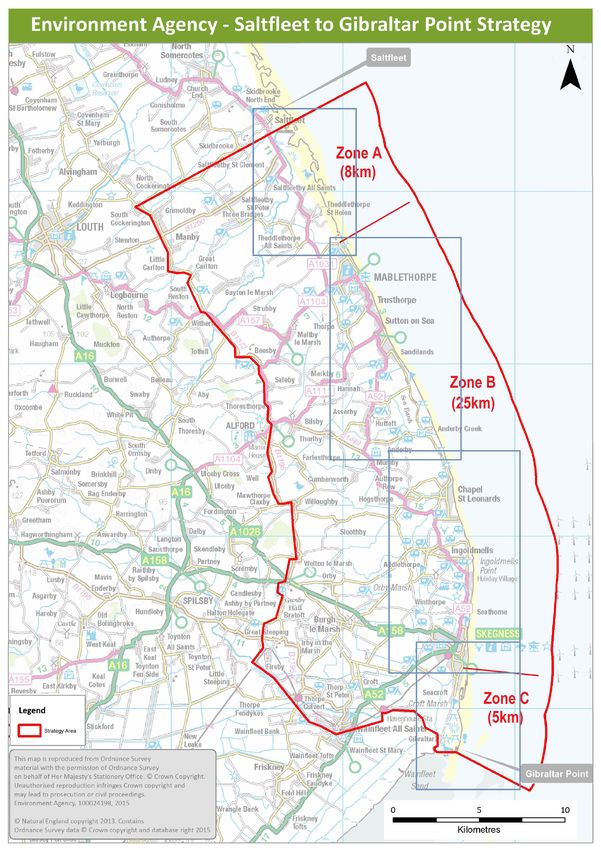
The strategy frontage between Saltfleet and Gibraltar Point covers 38km
of the open coast. Without sea defences floodwater would reach up
to 15km inland and could extend even further with predicted climate
change predictions and sea level rise. Across the strategy area, 20,000
residential properties, 1,700 businesses, 24,500 static caravans and 35,000
hectares of farmland are at risk of flooding. The Lincolnshire coast is also
home to a bustling tourist industry as well as a wealth of internationally
important wildlife and nature. Hundreds of thousands of people visit
the coast every year to enjoy the area’s beaches, its sand dunes and its
seaside resorts between Skegness and Mablethorpe.
1 https://consult.environmentagency.gov.uk/lincolnshire-and-northamp-
tonshire/sgp/ or write to Fé Toussaint, SGPS Engagement Officer, Ceres House,
Searby Road, Lincoln LN2 4DW. Freepost envelopes available on request.
2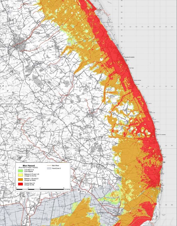
The Saltfleet to Gibraltar Point Strategy will meet the aspirations of the      the need for change. Currently both Zone A and Zone C are accreting
Shoreline Management Plan (SMP) for Flamborough Head to Gibraltar               (gaining sand quantities through coastal processes).
Point SMP2. This SMP is a partnership document that sets the policy
intent for this coastline. SMPs exist for every section of the English coast,   Having a healthy beach in front of a sand dune or seawall provides many
and they identify how flood risk is managed on the coast in the short           benefits in providing an effective form of coastal defence. Maintaining
term, medium term and long term.                                                beach profiles with shallow gradients absorb wave energy and provides
                                                                                protection to the existing seawalls. It limits wave depth, reducing
The Shoreline Management Plan policy for this frontage is to ‘hold the          overtopping and the risk of breach in stormy conditions.
line’, which means we keep the line of defence in approximately the             Beach nourishment also protects the underlying clay layer from long-
same location, over the 100-year plan period. However, in the long term         term exposure and erosion, which is crucial to the continued stability
there is potential for limited ‘managed realignment’, which means small
areas where defences may have to be set back. The current method of
protecting this frontage and maintaining the level of protection is to
nourish annually between Mablethorpe and Skegness, replacing the
sand lost through natural processed during the previous year.

Given the nature of the low-lying floodplain, a failure of the hard defences
at any location could result in widespread flooding across the whole
strategy area. Over half of normal high tides we currently experience
are above the level of the land behind the existing sea defences. This
means that without these important sea defences flooding would be
an extremely frequent occurrence, which could happen as many as
fourteen times a month based on current predictions. This frequency of
inundation would most likely render areas uninhabitable and unsafe for
any of their current uses.

The strategy area is divided into three sections: Zone A, Zone B and
Zone C (please see figure above). To date the evidence means our
nourishment work is concentrated within Zone B, the central area between
Mablethorpe and Skegness, as this is typically where beach widths are at
their narrowest and sand losses at their greatest. Management in Zones
A and C will continue to be monitored and triggers will determine
2     https://www.gov.uk/government/publications/shoreline-manage-
ment-plans-smps

                                                                                                                                                      3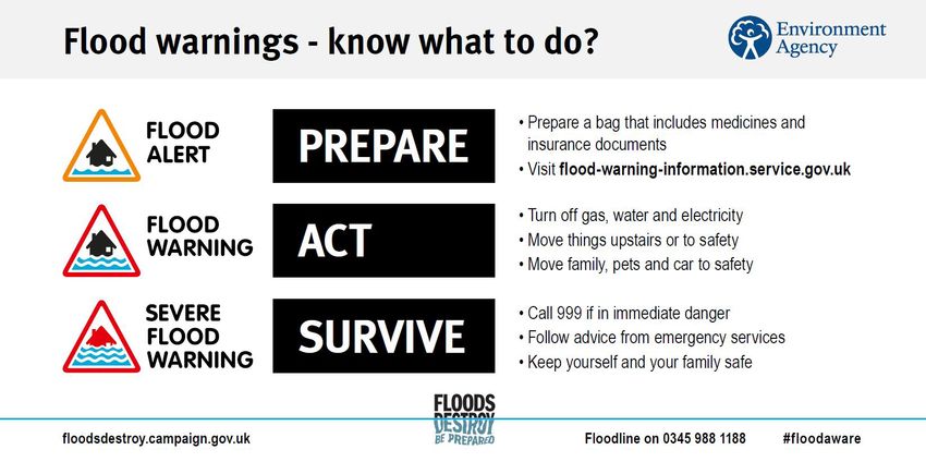
1.1 Vision and aims
of the foundations of the sea wall. In addition to offering effective     Through this strategy, we aim to create a better place for people and the
management of tidal flood risk, this solution provides a sandy beach to   environment, by working in partnership to manage the risk of flooding
the coastline, which supports a vibrant seaside tourism economy.          from the sea. The objectives of this strategy are to:
Beach nourishment in combination with both soft and hard defences
is currently the most cost effective way to manage tidal flood risk.      •      Provide sustainable flood risk management over the 100 year
                                However, through this strategy                   term of the strategy
                                review another solution has been          •      Mitigate against the risks of and adapt to the challenges of
                                identified which is likely to become             climate change and reduce our carbon footprint.
                                the preferred approach in the long-       •      Continue to investigate opportunities to secure the funding
                                term future. Due to the impact of                required to deliver the strategy.
                                climate change, our existing flood risk   •      Protect the social, recreational, cultural, agricultural and
                                management approach would require                commercial value of the coastal floodplain.
                                greater volumes of sand in the future,    •      Adapt to future opportunities, challenges and other key
                                potentially delivered at a higher                issues including tourism as well as environmental, social and
                                frequency than the current annual rate.          economic factors.
                                                                          •      Support sustainable and resilient development in the coastal
                                This means nourishment would                     floodplain for economic growth.
                                become more costly and would
                                increasingly come with a very large       The strategy has to work in parallel with our other work in this
                                carbon footprint, driving the need for    area, including cooperation with local communities and our routine
                                a change in flood risk management.        maintenance work on flood defences. While this strategy seeks to offer
                                This is why we are now introducing        an approach that is more sustainable in the long term, it will not be able
                                a new strategy, which will help the       to eliminate the risk of flooding completely. It is therefore vital that
                                area to continue to flourish amidst a     coastal communities take ownership of their risk of flooding and build a
                                changing climate.                         better understanding of what the risk may look like in the future. More
                                                                          information on flood risk and how to prepare for flooding can be found
                                                                          on our flooding webpage1.

                                                                          1      www.gov.uk/flooding

                                                                                                                                                   4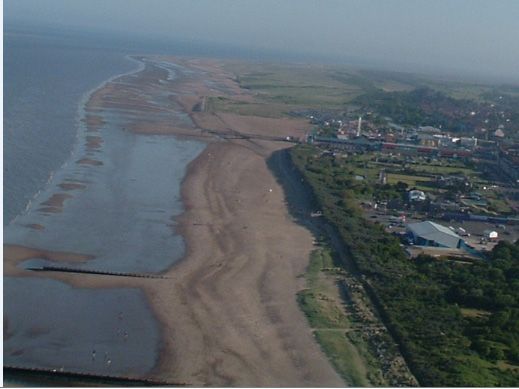
2. Background
The Lincolnshire coast has been a major tourist destination since the Victori-
an era, when resorts formed in Mablethorpe, Ingoldmells and Skegness. Over
                                                                                 1994-98
                                                                                 Beach nourishment
time, promenades and sea defences were put in place in these coastal towns.
                                                                                 begins - rebuilding the
                                                                                 beaches is completed
               1953                                                              by 1998. Annual
                                                                                 nourishment continued
               The 1953 floods caused                                            under the name
               devastation across the East                                       Lincshore.
               Coast of the UK. 307 people
               lost their lives, including 42 in                                 2013
               Lincolnshire.                                                     A storm surge, larger than
                                                                                 1953, hits the east coast. The
                                                                                 defences work well and protect
                                                                                 thousands of properties.
                                                                                 Following the surge, we
                                                                                 repaired damaged defences.

                                                                                 2016/17
                                                                                 The first workshops
                                                                                 with partners are held
                                                                                 for the new Saltfleet to
               1960s/70s                                                         Gibraltar Point Strategy.

               Further surges continue along                                     2018
               the coast. Each time, the beach                                   The public are asked their views on the
                                                                Furt             strategy options to manage flood risk in
               is stripped of sand exposing
               defences.                                                         the area. Lincolnshire Beach Managment
                                                                                 (LBM) 2018-2021 replaces Lincshore until
               Between 1984 and 1997, 70%                                        the Strategy is delivered in 2021.
               of the defences between                                                                                      th
               Mablethorpe and Skegness
               were upgraded.
                                                                                 2019
                                                                                 The draft strategy is published for
                                                                                 consultation.

                                                                                                                                 5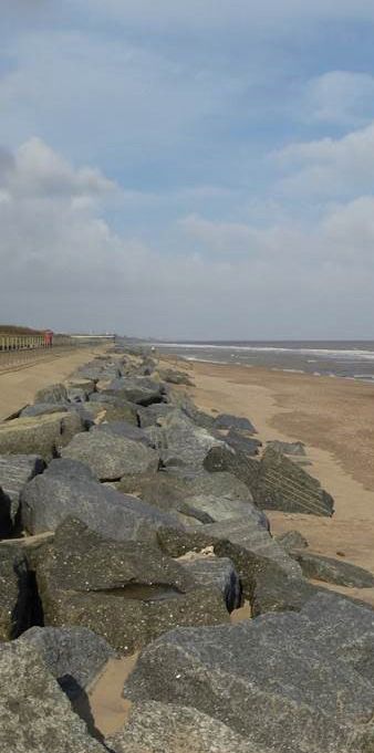
3. Option appraisal
Through an intensive strategy review process, we have identified a          Through      the    process     of
preferred approach that will help us to sustain the current standard        producing this strategy, we
of protection into the future. The strategy review process that led         assessed what flood damage
to the present draft included extensive consultation with partners,         would be avoided to residential
residents, business owners and other stakeholders as well as detailed       properties,     industry      and
environmental and economic assessments. The following section will          commercial premises against
explain these processes in more detail.                                     the cost of carrying out works
                                                                            for each shortlisted options over
We start a strategy review process by drawing up a long list of             the strategy period.
options. This strategy contained over one hundred possible flood risk
management options. We subsequently worked with national and local
                                                                            The flood damage avoided by continuing with flood risk management
partners to produce a shortlist of six options.
                                                                            has a much greater value than the cost of carrying out works, which
                                                                            means there is significant benefit in continuing with managing flood
The six shortlisted options were:
                                                                            risk for the strategy areas.
1.     Continuation of present management (annual beach nourishment);
2.     Using coarser sand, shingle or pebbles to nourish the beaches;
                                                                            The second element of the economic assessment was to look at any
3.     Rock groynes and nourishment;
                                                                            potential for added value. Some of the options that were shortlisted,
4.     Rock groynes and fishtails plus nourishment;
                                                                            especially those that include the introduction of structures in some
5.     Rock groynes, fishtails and varying volumes of nourishment; and
                                                                            way could present opportunities for added value in addition to the
6.     Rock groynes, fishtails and varying frequencies of nourishment
                                                                            flood risk elements of the strategy. For example, rock structures may
                                                                            form the basis for a pier, thereby creating new attractive space for local
We assessed the costs and economic benefits of all of the above shortlisted
                                                                            businesses. Added value would require additional funding as we are
options based on the following key factors:
                                                                            unable to use government flood risk management funds (Grant in
•     Damages avoided
                                                                            Aid) for direct investment outside the scope of flood risk management
•     Potential for added value
                                                                            measures. However, with the right partnership funding GiA may be
•     Funding required for each option, benchmarked to today’s prices
                                                                            used to “match fund” to support a range of additions for this coastline
                                                                            like a marina or lagoons that could offer an attract tourism destinations
                                                                            along the Lincolnshire coast.

                                                                            A final key element to our economic assessment of each option was to look
                                                                            at the funding required to deliver each option. While our current annual
                                                                            beach nourishment campaign is affordable, as outlined previously, it is
                                                                            likely the costs will rise significantly as the impact of climate change

                                                                                                                                                     6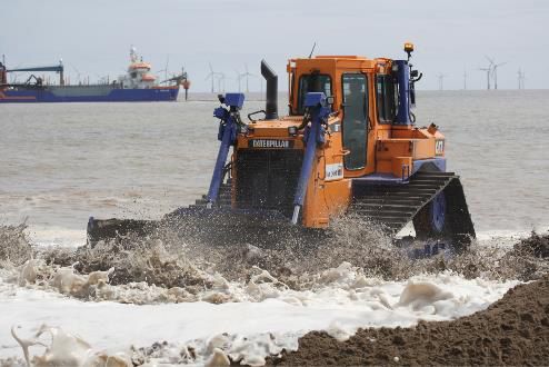
Visualisation of what structures may look like

increases. While introducing structures to the beach would incur a          The environmental assessments we have undertaken in collaboration
large cost upfront, it could reduce the frequency and volumes of sand       with our partners have influenced the draft strategy. Once the strategy
required for beach nourishment. This is why funding requirements have       is approved we will need carry out scheme specific environmental
to be considered over the full 100-year strategy for each of the options.   assessments before we can obtain the consents needed for the resulting
In addition to this economic assessment, our environmental specialists      works. We will also look to identify opportunities to improve existing
worked together with partners including Natural England, Historic           habitats and/or to create new areas where wildlife may thrive.
England, and Lincolnshire Wildlife Trust to assess the potential
environmental impacts (both positive and negative) of the preferred         Working closely with local stakeholders we were able to produce a
strategy approach of introducing structures in combination with             shortlist of options, and in 2018 we went to consultation with the public
continued nourishment.                                                      on this shortlist. This enabled us to formulate the preferred option for
                                                                            change, which we are now taking forward as part of this draft strategy.
We are undertaking a Strategic Environmental Assessment (SEA) ahead         During the 2018 consultation period, we organised a number of drop-
of the publication of our final strategy. We have produced a detailed       in events along the coast with over 500 people attending, and over 65%
Habitats Regulations Assessment (HRA) for the preferred option              returning a completed survey.
which was agreed by Natural England. The HRA and the draft SEA
Environmental Report set out at a strategic level the potential impacts As part of our wider engagement work we have been able to reach out
that could result from the preferred strategy approach, and identify how to a large range of audiences throughout coastal communities in the
these impacts could be mitigated.                                        Strategy area. This has been achieved by producing a number of strategy
                                                                         newsletters, contributing to both Parish and Town council community
                                                                         newsletters, extensive coverage in the local media, and attendance at
                                                                         community group meetings throughout the strategy area.

Visualisation of what structures may look like

                                                                                                                                                    7
4.1 The proposed strategy
This strategy recommends a preferred approach of combining Further triggers may be added where appropriate as the delivery of the
nourishment and structures on the beach as the most cost-effective and strategy progresses. Through modelling and monitoring work, we will
sustainable basis for future tidal flood risk management. Structures, continually assess conditions which will determine if we need to change
such as rock groynes or fishtails, are a long established form of defence in the future. When a change is triggered we will review our strategy
and are used on many coastlines both in the United Kingdom and across and may need to consult before making the necessary adjustments..
the world. The strategy is expected to be approved prior to 2021, and in
the meantime we will continue with our present management approach. The structures we propose to introduce as part of the strategy could take
a number of shapes and configurations. Rock fishtail structures or rock
The new strategy will be adaptive to change driven by triggers. Triggers groynes could both help manage tidal flood risk by absorbing energy
are best described as a change in circumstances that drives a change to from incoming waves and stabilising sand movement and losses. This
how flood risk is managed over the strategy period: will reduce the amount of work required to maintain beach levels and
protect both soft dunal systems and hard seawalls from the impact of
Trigger Examples wave action and tides. The reduction in sand required will also lead to a
Funding New government funding rules reduction in our carbon footprint for our flood risk management work.
Climate change Faster or slower sea level rise than
predicted; increased storm rates
Availability of materials Scarcity of non-renewable resources
Policy and plan change Change in local government plans
Implementation impacts Observed effects after implementing
step change
Technological development Availability of cost-saving new
technology
Asset condition and performance Decreased or increased losses of sand
on the beach
Defence failure Loss of beach
Resource resilience and succession Limited number of experts in the
planning relevant fields
Public and institutional acceptance of Public’s raised awareness of flood risk
works needed to manage flood risk following a significant event
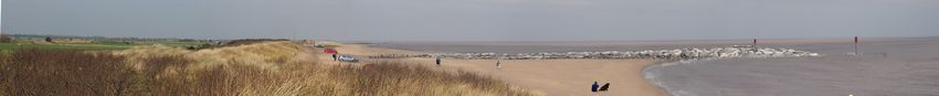
The Lincolnshire coast is home to Europe’s largest concentration of static
caravans.
84.2 Strategy delivery
The delivery of works over the full strategy period will be determined by We will need to continuously monitor the coast and review our approach
the impact(s) of the above triggers, and we have produced an indicative to flood risk management between Saltfleet and Gibraltar Point. It
timeline setting out our current programme. is expected that nourishment requirements will reduce significantly
after the rock structures have had time to establish, which could lead
In the first five years of delivery - starting from 2021, a focus will be placed to significant overall reduction of cost while continuing to provide
on further development of the plans for the introduction of structures, Lincolnshire’s coastal communities with a good standard of protection
including completion of the relevant environmental assessments, from tidal flooding.
and obtaining the required permissions and consents. This process is
required ahead of any construction on the beach, and will be essential to
the implementation of the structures.
During this phase, we will need to consider rock structure configurations
and designs for consultation and potential additional funding
opportunities.
Subject to the outcome of the first phase, the second five-year phase
of the strategy we look to introduce the first set of rock structures in
combination with continued beach nourishment. The exact location of
the structures will be determined during the detailed design phase and
will be informed by technical engineering knowledge, consultation with
stakeholders, funders and local residents, as well as engagement with
any other interested parties. It is likely that the first set of structures
will be built in Zone B, between Mablethorpe and Skegness, where
we already experience the greatest losses of sand each year, known as
‘hotspots’.
Following construction of the first set of structures, we will need to
closely monitor their performance to assess crucial data to determine
future configurations, positioning and size. Timing for the delivery of
further structures will depend on when triggers determine the need for
change.
94.3 What’s next?
The draft strategy will be available for consultation from 3 June to 25
August 2019. We invite any interested parties, including residents, 2019-2021
tourists, business owners and representatives of partner organisations Strategy approval period
to submit their views on this strategy by visiting https://consult.
environment-agency.gov.uk/lincolnshire-and-northamptonshire/sgp/
or by requesting a paper copy of the consultation documents.1 2021-2025
First phase of delivery - nourishment
Following the consultation, we will produce a final strategy which will continues whilst permissions are
need to pass the relevant internal and external approval processes before obtained
being published.
Once the strategy has been published, it will remain a live document 2025-2030
which is flexible enough to adapt to any need for change, determined by Implementation of structures
trigger points. We will continue to work and engage with partners and
communities throughout the delivery of the strategy.
1 https//consult.environment-agency.gov.uk/lincolnshire-and-northamp-
tonshire/sgp/ or write to Fé Toussaint, SGPS Engagement Officer, Ceres House,
Searby Road, Lincoln LN2 4DW. Freepost envelopes available on request.
10You can also read