SEA Environmental Report - Non-Technical Summary for Proposed Amendments
←
→
Page content transcription
If your browser does not render page correctly, please read the page content below

SEA
           Environmental
                  Report
  Non-Technical Summary
for Proposed Amendments
SEA ENVIRONMENTAL REPORT

   APPENDIX III – NON-TECHNICAL SUMMARY

                                      FOR

       RELEVANT PROPOSED MATERIAL ALTERATIONS
                                     TO THE

                      DRAFT
             DÚN LAOGHAIRE-RATHDOWN
        COUNTY DEVELOPMENT PLAN 2022-2028

for:       Dún Laoghaire-Rathdown County Council
           County Hall
           Marine Road
           Dún Laoghaire

by:        CAAS Ltd.
           1st Floor
           24-26 Ormond Quay Upper
           Dublin

                              NOVEMBER 2021
SEA Environmental Report Appendix III: Non-Technical Summary

                                                   Table of Contents

Section 1            Introduction and Terms of Reference ..................................................... 1

Section 2            The Draft Plan and associated Proposed Material Alterations................ 4

  2.1      Introduction .................................................................................................................... 4
  2.2      Content of the Draft Plan .................................................................................................. 4
  2.3      Overall Vision and Aims .................................................................................................... 4
  2.4      Proposed Material Alterations ............................................................................................ 5
  2.5      Strategic work undertaken by the Council to ensure contribution towards environmental
  protection and sustainable development ......................................................................................... 5
  2.6      Relationship with other relevant Plans and Programmes ...................................................... 6

Section 3            The Environmental Baseline .................................................................... 7

  3.1      Introduction .................................................................................................................... 7
  3.2      Likely Evolution of the Environment in the Absence of the Draft Plan and associated Proposed
  Material Alterations ....................................................................................................................... 7
  3.3      Biodiversity and Flora and Fauna ....................................................................................... 8
  3.4      Population and Human Health ........................................................................................... 9
  3.5      Soil ............................................................................................................................... 10
  3.6      Water ........................................................................................................................... 12
  3.7      Air and Climatic Factors .................................................................................................. 16
  3.8      Material Assets .............................................................................................................. 17
  3.9      Cultural Heritage ............................................................................................................ 19
  3.10     Landscape ..................................................................................................................... 20
  3.11     Strategic Environmental Objectives .................................................................................. 24

Section 4            Alternatives ........................................................................................... 25

  4.1        Introduction .................................................................................................................. 25
  4.2        Limitations in Available Alternatives ................................................................................. 25
  4.3        Type 1: Alternatives for an Ecosystem Services Approach to the Plan ................................. 25
  4.4        Type 2: Land Use Zoning ................................................................................................ 26
  4.5        Type 3: Alternatives for Additional Accommodation in Existing Built-up Areas ...................... 27
  4.6        Type 4: Densities ........................................................................................................... 28
  4.7        Type 5: Strategic Land Reserve for Old Connaught ........................................................... 28

Section 5            Summary of Effects arising from Plan ................................................... 31

Section 6            Mitigation and Monitoring Measures .................................................... 32

  6.1        Mitigation ...................................................................................................................... 32
  6.2        Monitoring ..................................................................................................................... 32

CAAS for Dún Laoghaire-Rathdown County Council                                                                                                      i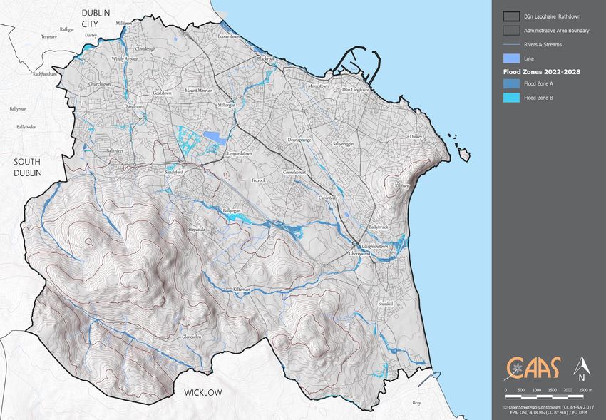
SEA Environmental Report Appendix III: Non-Technical Summary
Section 1 Introduction and Terms of Reference
This is the Non-Technical Summary of the Environmental Report for relevant Proposed Material Alterations
to the Draft Dún Laoghaire-Rathdown County Development Plan 2022-2028 (hereafter referred to as ‘the
Plan’). The purpose of the Environmental Report is to provide a clear understanding of the likely
environmental consequences of decisions regarding the Proposed Material Alterations. The Environmental
Report has been prepared as part of a Strategic Environmental Assessment (SEA) process for the Proposed
Material Alterations.
The Proposed Material Alterations were screened for the need to undertake SEA. Certain Proposed Material
Alterations were determined as requiring full SEA. The SEA Screening Determination accompanies the SEA
Environmental Report and the Proposed Material Alterations document. Appendix II to the SEA
Environmental Report comprises the SEA Screening Report that was prepared to inform the SEA Screening
Determination.
This SEA Environmental Report provides the findings of the assessment and will be placed on public display
alongside the Proposed Material Alterations. The Elected Members will be required to take account of this
document, the Proposed Material Alterations and any submissions received on these after public display.
The SEA is being undertaken in order to comply with Section 12 of the Planning and Development Act, as
amended.
What is SEA?
SEA is a systematic process of predicting and evaluating the likely environmental effects of implementing a
proposed plan, or other strategic action, in order to ensure that these effects are appropriately addressed
at the earliest appropriate stage of decision-making on a par with economic, social and other
considerations.
Why is SEA needed? The Benefits
SEA is the planning authority’s and the public’s guide to what are generally the best areas for development
in the County.
The SEA for the Draft Plan provided the planning authority and the public a guide to what are generally the
best areas for development in the County.
SEA enables the planning authority to direct development towards robust, well-serviced and connected
areas in the County – thereby facilitating the general avoidance of incompatible areas in the most
sensitive, least well-serviced and least well-connected areas.
SEA provides greater certainty to the public and to developers. Plans are more likely to be adopted without
delays or challenges and planning applications are more likely to be granted permission. Environmental
mitigation is more likely to cost less.
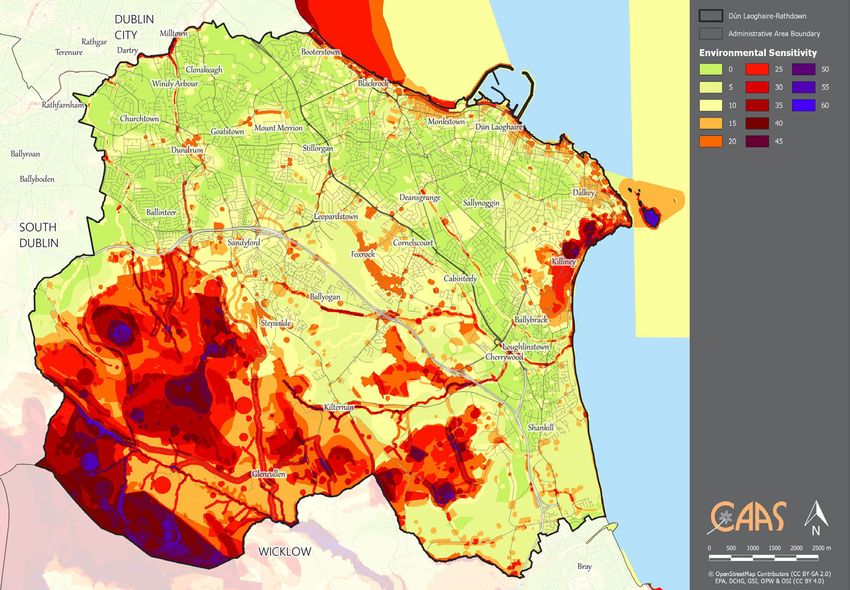
An overlay of environmental sensitivities is shown on Figure 1.1.
The overlay mapping shows that environmental sensitivities are not evenly distributed throughout the
County. Most of the County is identified as having low to moderate levels of sensitivity.
The most sensitive areas in the County include:
Parts of the rural areas in the south west of the County, on account of the High Amenity Area designation, archaeological
heritage sensitives, areas of extreme and high groundwater vulnerability and European Site ecological designations along
the borders with South Dublin and Wicklow County Councils;
Parts of the coastline and adjacent coastal areas, on account of European Site and proposed Natural Heritage Area
ecological designations, Protected Views and Prospects, extreme groundwater vulnerability and coastal flood risk;
Certain locations and areas within the existing built-up footprint of the County, on account of cultural heritage designations,
including entries to the Record of Monuments and Places, Entries to the Record of Protected Structures and Architectural
Conservation Areas; and
Certain areas that are adjacent to streams and rivers, on account of flood risk.
CAAS for Dún Laoghaire-Rathdown County Council 1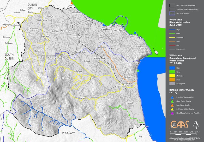
SEA Environmental Report Appendix III: Non-Technical Summary

The Plan directs incompatible development away from the most sensitive areas in the County and focuses
on directing: compact, sustainable development within and adjacent to the existing built-up footprint; and
sustainable development elsewhere, including in the rural area of the County. Development of areas within
and adjacent to the existing built-up footprint, which are generally more robust, better serviced and better
connected, will contribute towards environmental protection and sustainable development, including
climate mitigation and adaptation.

Compact development can be accompanied by placemaking initiatives to enable the County’s settlements
to become more desirable places to live – so that they can sustainably accommodate new residents and
maintain and improve services to existing and future communities.

Compatible sustainable development in the County’s sensitive areas is also provided for, subject to various
requirements relating to environmental protection and management being met.

Difficulties Encountered during the SEA process

No significant difficulties have been encountered during the undertaking of the assessment to date.

There is a data gap relating to WFD surface water status data. There are a number of waterbodies within
the Plan area with overall status currently not assigned to them and the term “unassigned status” applies
in respect of these waterbodies. The SEA ensured that the Plan contains measures that will contribute
towards the maintenance and improvement of status of all water bodies within the zone of influence.

What happens at the end of the process?

The SEA Environmental Report prepared for the Draft Plan will be finalised in advance of adoption of the
Plan taking into account, among other things, the content of the SEA Environmental Report for the
Proposed Material Alterations to which this Non-Technical Summary relates. An SEA Statement will be
prepared which will summarise, inter alia, how environmental considerations have been integrated into the
Plan.

CAAS for Dún Laoghaire-Rathdown County Council                                                            2
SEA Environmental Report Appendix III: Non-Technical Summary

Figure 1.1 Environmental Sensitivities Map

CAAS for Dún Laoghaire-Rathdown County Council                                                                  3
SEA Environmental Report Appendix III: Non-Technical Summary
Section 2 The Draft Plan and associated Proposed
Material Alterations
2.1 Introduction
The Dún Laoghaire-Rathdown County Development Plan is a land use plan and overall strategy for the
proper planning and sustainable development of the functional area of County Dún Laoghaire-Rathdown
over the six-year period 2022-2028. Not later than four years after the adoption of the Plan, the Council is
required to review it and commence the preparation of a new Plan.
2.2 Content of the Draft Plan
The Draft Plan, to which the Proposed Material Alterations relate, includes a Written Statement, that
provides the development policies, Core Strategy and mandatory and discretionary objectives for different
policy areas addressed by the Development Plan. The Written Statement is divided into 15 separate
chapters setting out various policies and objectives under the headings of:
Chapter 1: Introduction, Vision and Context
Chapter 2: Core Strategy
Chapter 3: Climate Action
Chapter 4: Neighbourhoods, People, Place and Homes
Chapter 5: Transport and Mobility
Chapter 6: Enterprise and Employment
Chapter 7: Towns, Villages and Retail Development
Chapter 8: Green Infrastructure and Biodiversity
Chapter 9: Open Space and Recreation
Chapter 10: Environmental Infrastructure
Chapter 11: Heritage
Chapter 12: Development Management
Chapter 13: Land Use Zoning Objectives
Chapter 14: Specific Local Objectives
Chapter 15: Implementation, Monitoring and Evaluation
The Written Statement is accompanied by Land Use Zoning Maps, this SEA Environmental Report, a
Natura Impact Report, a Strategic Flood Risk Assessment and other supporting appendices.
2.3 Overall Vision and Aims
The Vision of the Plan is: ‘to embrace inclusiveness, champion quality of life through healthy placemaking,
grow and attract a diverse innovative economy and deliver this in
a manner that enhances our environment for future generations.’
To deliver on the Development Plan Vision over the lifetime of the Plan there are a number of key cross
cutting and interrelated themes or Strategic County Outcomes which underpin the Plan as follows:
1. Creation of a climate resilient County;
2. Creation of a compact and connected County;
3. Creation of a liveable network of towns and villages;
4. Creation of an inclusive and healthy County; and
5. Creation of a vibrant economic County.
CAAS for Dún Laoghaire-Rathdown County Council 4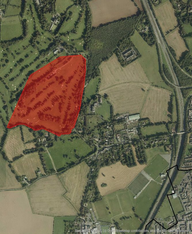
SEA Environmental Report Appendix III: Non-Technical Summary
2.4 Proposed Material Alterations
The Proposed Material Alterations are outlined in detail in the accompanying Proposed Material Alteration
document. The “Alteration References” provided in this report can be used to locate this detail in the
accompanying Proposed Material Alteration document.
Alterations proposed include those relating to text and to maps.
The Proposed Material Alterations were screened for the need to undertake SEA and the alterations below
were determined as requiring full SEA. The SEA Screening Determination accompanies this SEA
Environmental Report and the Proposed Material Alterations document. Appendix II to this SEA
Environmental Report comprises the SEA Screening Report that was prepared to inform the Determination.
Proposed Material Alterations requiring SEA and consideration in this SEA Environmental Report1 are as
follows:
Alteration Ref:
No. 83
No. 84
No. 208
No. 218
No. 265
No. 269
No. 306
No. 314
No. 316
No. 356
No. 357
Map No. 9 Mapping Amendment M911 - to add Strategic Land
Reserve at Kiltiernan
2.5 Strategic work undertaken by the Council to ensure
contribution towards environmental protection and
sustainable development
Far in advance of both the submission of the Chief Executive’s Draft Plan to the Elected Members for
approval and the placing of the Draft Plan on public display, Dún Laoghaire-Rathdown County Council
undertook various background work in order to inform the preparation of the Plan.
The findings of this strategic work have been integrated into the Plan and will contribute towards both
environmental protection and management and sustainable development within the County.
Strategic work undertaken by the Council includes background work in relation to Plan Strategies and other
provisions for a variety of sectors, including:
Strategic Environmental Assessment (SEA);
Appropriate Assessment (AA)2; and
Strategic Flood Risk Assessment (SFRA) 3.
The undertaking of this SEA process and associated Appropriate Assessment and Strategic Flood Risk
Assessment processes were part of this strategic work and contributed towards the integration of
environmental considerations into individual Plan provisions as detailed in Section 6 of this report.
1
For detail please refer to Proposed Material Alterations document.
2
Appropriate Assessment (AA) Screening and Stage 2 AA are being undertaken alongside the Plan and Proposed Material Alterations. The requirement
for AA is provided under the EU Habitats Directive (Directive 1992/43/EEC). The emerging conclusion of the AA is that the Plan will not affect the
integrity of the European Sites, alone or in combination with other plans or projects (subject to exceptions). The Proposed Material Alterations are
accompanied by an AA Natura Impact Report, which has informed this SEA Environmental Report.
3
SFRA is being undertaken to inform the preparation of the Draft Plan and the Proposed Material Alterations. The SFRA process has informed this report.
The SFRA has considered the Proposed Material Alterations and finds that all Proposed Material Alterations, comply with “The Planning System and Flood
Risk Management Guidelines for Planning Authorities” (DEHLG/OPW, 2009).
CAAS for Dún Laoghaire-Rathdown County Council 5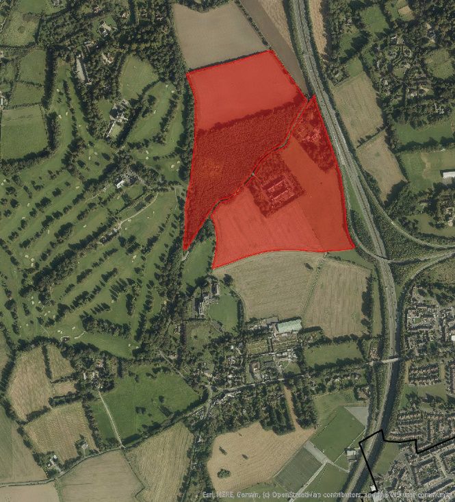
SEA Environmental Report Appendix III: Non-Technical Summary

2.6          Relationship with other relevant Plans and Programmes
The Draft Plan, to which the Proposed Material Alterations relate, sits within a hierarchy of statutory
documents setting out public policy for, among other things, land use planning, infrastructure, sustainable
development, tourism, environmental protection and environmental management. The Plan must comply
with relevant higher-level strategic actions and will, in turn, guide lower level strategic actions.

The National Planning Framework (NPF) sets out Ireland’s planning policy direction up to 2040. The NPF is
to be implemented through Regional Spatial and Economic Strategies (RSESs) and lower tier Development
Plans and Local Area Plans. The RSES for the Eastern and Midland Region sets out objectives for land use
planning, tourism, infrastructure, sustainable development, environmental protection and environmental
management that have been subject to environmental assessment and must be implemented through the
County Development Plan.

As required by the Planning and Development Act 2000, as amended, the Draft County Development Plan
is consistent with and conforms with national and regional policies, plans and programmes, including the
NPF and the RSES for the Eastern and Midland Region. The County Development Plan may, in turn, guide
lower level strategic actions, such as the Local Area Plans that will be subject to their own lower-tier
environmental assessments.

In order to be realised, projects included in the County Development Plan (in a similar way to other
projects from any other sector) will have to comply, as relevant, with various legislation, policies, plans and
programmes (including requirements for lower-tier Appropriate Assessment, Environmental Impact
Assessment and other licencing requirements as appropriate) that form the statutory decision-making and
consent-granting framework.

CAAS for Dún Laoghaire-Rathdown County Council                                                               6
SEA Environmental Report Appendix III: Non-Technical Summary
Section 3 The Environmental Baseline
3.1 Introduction
The summary of the environmental baseline of the County is described in this section. This baseline
together with the Strategic Environmental Objectives, which are identified in Section 3.11, is used in order
to identify, describe and evaluate the likely significant environmental effects of implementing the Draft Plan
and in order to determine appropriate monitoring measures.
3.2 Likely Evolution of the Environment in the Absence of the
Draft Plan and associated Proposed Material Alterations
In the absence of a new Plan it is uncertain how permission for new development would be applied for and
considered.
The 2016-2022 Plan has contributed towards environmental protection within the County. If the 2016-2022
Plan was to expire and not be replaced by the 2022-2028 Plan, this would result in a deterioration of the
County’s planning and environmental protection framework. Although higher level environmental protection
objectives – such as those of various EU Directives and transposing Irish Regulations – would still apply,
the deterioration of this framework would mean that new development would be less coordinated and
controlled. As a result, there would be an increased likelihood in the extent, magnitude and frequency of
adverse effects on all environmental components occurring, including:
Arising from both construction and operation of development and associated infrastructure:
Loss of/damage to biodiversity in designated sites (including European Sites and Wildlife Sites) and Annexed habitats and
species, listed species, ecological connectivity and non-designated habitats; and disturbance to biodiversity and flora and
fauna;
Habitat loss, fragmentation and deterioration, including patch size and edge effects; and
Disturbance (e.g. due to noise and lighting along transport corridors) and displacement of protected species such as birds
and bats.
Potential adverse effects arising from flood events.
Potential interactions if effects arising from environmental vectors.
Potential adverse effects on the hydrogeological and ecological function of the soil resource, including as a result of
development on contaminated lands.
Potential for riverbank and coastal erosion.
Potential adverse effects upon the status of water bodies and entries to the WFD Register of Protected Areas (ecological
and human value), arising from changes in quality, flow and/or morphology.
Increase in flood risk and associated effects associated with flood events.
Failure to provide adequate and appropriate waste water treatment (water services infrastructure and capacity ensures the
mitigation of potential conflicts).
Failure to adequately treat surface water run-off that is discharged to water bodies (water services infrastructure and
capacity ensures the mitigation of potential conflicts).
Failure to comply with drinking water regulations and serve new development with adequate drinking water (water services
infrastructure and capacity ensures the mitigation of potential conflicts).
Increases in waste levels.
Potential impacts upon public assets and infrastructure.
Potential interactions at local level between agricultural waste and soil, water, biodiversity and human health - including
nitrogen deposition as a result of agricultural activities. However, this is likely to be a less significant issue at County level
due to low levels of intensive agriculture.
Potential conflict between development under the Plan and aiming to reduce carbon emissions in line with local, national
and European environmental objectives.
Potential conflicts between transport emissions, including those from cars, and air quality.
Potential conflicts between increased frequency of noise emissions and protection of sensitive receptors.
Potential conflicts with climate adaptation measures including those relating to flood risk management.
Potential effects on protected and unknown archaeology and protected architecture arising from construction and operation
activities.
Occurrence of adverse visual impacts and conflicts with the appropriate protection of designations relating to the landscape.
CAAS for Dún Laoghaire-Rathdown County Council 7SEA Environmental Report Appendix III: Non-Technical Summary
3.3 Biodiversity and Flora and Fauna
Green space, which makes up a large part of the southern portion of the County, consists of a variety of
habitats including corridors that provide for the movement of wildlife. Green space within Dún Laoghaire-
Rathdown is comprised of agricultural lands, bogs and heath in the uplands, woodlands, grasslands, Marlay
Park, Deerpark, Cabinteely Park, Shanganagh Park and a number of other open spaces within and adjacent
to the County’s existing built footprint.
The Loughlinstown River, with tributaries such as the Shanganagh River and the Cabinteely, Ballyogan and
the Glenamuck Streams, forms the largest catchment in Dún Laoghaire-Rathdown. The southernmost
branch of the River, also known as Brides Glen stream, is particularly rich in biodiversity. Trout, otter, and
bats occur in the river while kingfisher may also be present. Other rivers supporting good areas of
biodiversity include the Little Dargle, which rises in Three Rock Mountain and flows through Marlay Park,
and the Glencullen River, which drains the uplands around Glendoo and Glencullen Mountains before
crossing the County boundary into County Wicklow.
The County’s coastline, including areas such as South Dublin Bay and Dalkey, provides a number of
habitats for a variety of species. The Shanganagh coastline represents a long stretch of the Killiney Bay
shoreline, extending from Ballybrack to Bray in Wicklow. The area is important particularly for its
sedimentary cliffs, displaying clear geological time sequences through the quaternary period. The shoreline
also has an example of a drowned forest, visible in the sand only at extreme low tide. Coastal habitats in
Ireland provide ecosystem services including biodiversity, recreation, coastal protection and food provision.
Coastal squeeze describes the impact on coastal habitats from the combined pressures of climate change
at sea and human activities on land. Climate change is predicted to cause sea level rise and increased
storminess, which in turn has the potential to lead to greater frequency of coastal flooding and erosion
events, and eventually to landward movement of coastlines and coastal habitats.
Dalkey Islands comprise the uninhabited islands of Dalkey Island, Lamb Island and Maidens’ Rock. The
islands contain important ecological, archaeological, architectural, and cultural heritage. The underlying
rock is granite with rough terrain with rock outcrops, semi-natural grasslands, dense bracken framed by a
rocky shoreline with low granite cliffs4. The Islands are a designated SPA (Dalkey Islands SPA) and SAC
(Rockabill to Dalkey Island SAC) and form part of the Dalkey Coastal Zone and Killiney Hill pNHA.
The upland areas around Three Rock and Two Rock Mountains are valuable for their heath habitats and
their exposed rocky outcrops. Red grouse, an upland bird species thought to be in decline across the
country, occurs in this area.
Man-made habitats within the Plan area are also important biodiversity areas. Gardens provide habitats for
a range of wildlife including various bird species, invertebrates, such as bees and butterflies and mammals,
such as hedgehogs, mice, rats and foxes. These species move around between gardens using hedgerows
and vegetated areas. These urban green spaces, however small, are therefore of importance as they form
part of a network of green spaces across the Plan area including gardens, parks, graveyards, amenity
walks, railway lines and patches of woodland and scrub within which animals and plants continue to thrive.
Marshes are found on level ground near slow-flowing river banks and in other places where mineral or
shallow peaty soils are waterlogged, and where the water table is close to ground level for most of the
year and tend to be comparatively species-rich especially with herbs. Booterstown Marsh in the north-east
of the Plan area is the only remaining area of saltmarsh in Dún-Laoghaire-Rathdown. The marsh is an
important habitat for a range of species including birds, fish, invertebrates and rare plants It is also of
international importance as a roosting and feeding area for waders and wildfowl. 5
The zone of influence of the Plan, to which the Proposed Material Alterations relate, beyond the County
area with respect to impacts upon ecology via surface waters upon ecological resources – including
designated ecology – can be estimated to be areas within 15 km of the County boundary and all
downstream areas of catchments which drain the County
4
The Dalkey Islands Conservation Plan 2014-2024
5
Treasuring our Wildlife - Dún Laoghaire-Rathdown Biodiversity Plan 2009-2013.
CAAS for Dún Laoghaire-Rathdown County Council 8SEA Environmental Report Appendix III: Non-Technical Summary
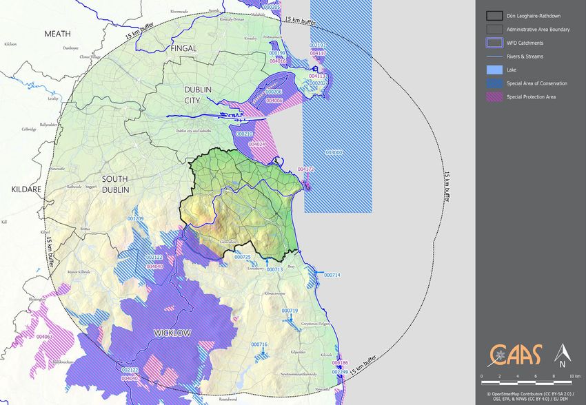
Designated sites within and adjacent to the County include Special Areas of Conservation6 (SACs) and
Special Protection Areas7 (SPAs). These are mapped on Figure 3.1. Other ecological designations occur
within and adjacent to the County and these are detailed in the main SEA Environmental Report.
Existing Problems
Ireland’s Article 17 report on the Status of EU Protected Habitats and Species in Ireland (DCHG, 2019)
identifies various Irish, EU-protected habitats and species to be of unfavourable status and many to be still
declining, although it also identifies that a range of positive actions are underway. Categories for pressures
and threats on Ireland’s habitats and species identified by the report comprise:
Agriculture;
Forestry;
Extraction of resources (minerals, peat, non-renewable energy resources);
Energy production processes and related infrastructure development;
Development and operation of transport systems;
Development, construction and use of residential, commercial, industrial and recreational infrastructure and areas;
Extraction and cultivation of biological living resources (other than agriculture and forestry);
Military action, public safety measures, and other human intrusions;
Alien and problematic species;
Mixed source pollution;
Human-induced changes in water regimes;
Natural processes (excluding catastrophes and processes induced by human activity or climate change);
Geological events, natural catastrophes;
Climate change; and
Unknown pressures, no pressures and pressures from outside the Member State.
The Plan, to which the Proposed Material Alterations relate, includes measures to contribute towards the
protection of biodiversity and flora and fauna and associated ecosystem services.
Previous changes in land uses arising from human development have resulted in a loss of biodiversity and
flora and fauna however, legislative objectives governing biodiversity and fauna were not identified as
being conflicted with.
3.4 Population and Human Health
In the 2016 Census the total population of County Dún Laoghaire-Rathdown was identified as being of
218,018 persons, an increase in total population in the County by c. 11% (c. 24,000 persons) over a 10-
year period from 2006.
The new population provided for in the Draft Plan, to which the Proposed Material Alterations relate, will
interact with various environmental components. Potential interactions include:
Increase in demand for wastewater treatment at the municipal level;
Recreational and development pressure on habitats and landscapes;
Increase in demand for water supply and associated potential impact of water abstraction from the rivers;
Potential interactions in flood-sensitive areas; and
Potential effects on water quality
Human health has the potential to be impacted upon by environmental vectors (i.e. environmental
components such as air, water or soil through which contaminants or pollutants, which have the potential
to cause harm, can be transported so that they come into contact with human beings). Hazards or
nuisances to human health can arise as a result of exposure to these vectors arising from incompatible
adjacent land uses for example. These factors have been considered with regard to the description of: the
baseline of each environmental component; and the identification and evaluation of the likely significant
environmental effects of implementing the Plan, to which the Proposed Material Alterations relate.
Existing Problems
There is historic and predictive evidence of flooding in various locations across the County (see information
on Strategic Flood Risk Assessment at Section 3.6).
6
SACs have been selected for protection under the European Council Directive on the conservation of natural habitats and of wild fauna and flora
(92/43/EEC) due to their conservation value for habitats and species of importance in the European Union. The Habitats Directive seeks to establish
Natura 2000, a network of protected areas throughout the EU. It is the responsibility of each member state to designate SACs to protect habitats and
species, which, together with the SPAs designated under the 1979 Birds Directive, form Natura 2000.
7
SPAs have been selected for protection under the 1979 European Council Directive on the Conservation of Wild Birds (79/409/EEC) - referred to as the
Birds Directive - due to their conservation value for birds of importance in the EU.
CAAS for Dún Laoghaire-Rathdown County Council 9SEA Environmental Report Appendix III: Non-Technical Summary
The greatest health risk from radiation in Ireland is caused by radon. The presence of radon gas, a
naturally occurring radioactive gas that originates from the decay of uranium in rocks and soils, occurs
across the country. It accounts for more than half of the total radiation dose received by the Irish
population. As a known carcinogen, in the same category as tobacco smoke and asbestos it is a cause of
lung cancer. Exposure to radon for long periods or at high concentrations can lead to lung cancer. The
number of homes within the County with radon levels above the reference level is within the normal range
experienced in other locations across the country8.
Information on the status of groundwaters and surface waters is provided under Section 3.6 while
information on water services is provided under Section 3.8.
3.5 Soil
Urban soils9 (mainly in the northern, most built-up parts of the Plan area) and lithosol soils10 (mainly in the
south and south-western parts of the Plan area) are the two most dominant soil types in the County. Other
soil types identified include:
Alluvial soils11 (in the flood plains of rivers and streams);
Brown podzols12 (mainly in the south of the Plan area);
Luvisols13 (in the coastal south-east); and
Brown earths14 (mainly in the east and south-east of the Plan area).
Peatlands are unique systems comprising of peat soil providing as significant carbon stores and supporting
a range of unique species. Active blanket bogs and active raised bogs are considered to be priority
habitats, listed on Annex I of the EU Habitats Directive. Peat soils are often indicative of areas that are the
most sensitive to development due to ecological sensitivities and impeded drainage issues. The
ombrotrophic (rain-fed) peat soils in the south-west of the Plan area are also a subject to ecological
designations.
Outcropping rock is identified in a number of upland and coastal locations.
The GSI have a suite of data sources available that would be useful in planning and assessing individual
projects with regard to the environmental topic(s) of soil and/or material assets. These include:
Bedrock mapping;
Quaternary and Physiographic mapping; and
National Aquifer and Recharge mapping.
Geological Survey of Ireland coordinates the Irish Geological Heritage Programme, which seeks to identify
and select sites of geological interest within each county across the country. The audit of County
Geological Sites in Dún Laoghaire-Rathdown was completed in 2014 and identified 12 County Geological
Sites15. Concentrations of these designations can be found in the upland areas and along the coast.
Given the urban nature of the County and the range of land use activities which have taken place
historically, soils have been contaminated in the past. Such contamination has the potential to affect water
quality, biodiversity and flora and fauna and human health. Under the Plan (Chapter 12), to which the
Proposed Material Alterations relate, where brownfield redevelopment is proposed, adequate and
appropriate investigations are required to be carried out into the nature and extent of any soil and
groundwater contamination and the risks associated with site development work.
8
Mapping available at http://www.epa.ie/radiation/radonmap
9
Urban soils are soils which have been disturbed, transported or manipulated by human activity in the urban environment and are often overlain by a
non-agricultural, man-made surface layer that has been produced by mixing, filling or by contamination of land surfaces in urban and suburban areas.
10
Lithosols are shallow non-calcareous soils, commonly overlying hard rock or skeletal and gravelly material. They tend to be stony soils, or with
shattered bedrock and are associated with frequent rock outcrops. Their use-range is usually limited to rough grazing.
11
These are associated with alluvial (clay, silt or sand) river deposits.
12
Brown podzol soils are characterised by dark brown humus-mineral soil covered with a thin mat of partly decayed leaves.
13
Luvisol soils are generally fertile, widely used for agriculture and associated with significant accumulation of clay.
14
Brown earths are well drained mineral soils, associated with high levels of natural fertility.
15
Geological Survey of Ireland (2014) The Geological Heritage of Dún Laoghaire-Rathdown. An Audit of County Geological Sites in Dún Laoghaire-
Rathdown.
CAAS for Dún Laoghaire-Rathdown County Council 10SEA Environmental Report Appendix III: Non-Technical Summary Figure 3.1 European Sites within and adjacent to the County CAAS for Dún Laoghaire-Rathdown County Council 11
SEA Environmental Report Appendix III: Non-Technical Summary
3.6 Water
Surface and Groundwater
Most of the Plan area is located within the catchment of the Liffey and Dublin Bay (an area drained by the
River Liffey and by all streams entering tidal water between Sea Mount and Sorrento Point). The Plan area
is also partially drained by the Avoca-Vartry catchment (an area drained by the Rivers Avoca and Vartry
and by all streams entering tidal water between Sorrento Point and Kilmichael Point). The main rivers
within the Plan area are the Loughlinstown River, the Glencullen River, the Little Dargle River and the River
Dodder.
The Water Framework Directive (WFD) defines ‘overall surface water status’ as the general expression of
the status of a body of surface water, determined by the poorer of its ecological status and its chemical
status. Thus, in order to achieve ‘good surface water status’ both the ecological status and the chemical
status of a surface water body need to be at least ‘good’. The WFD surface water status (2013-2018), for
rivers and coastal waters within and surrounding the County is shown on and on Table 3.1.
The WFD status of most of the rivers and streams within the County is classified as moderate, good and
high, however a section of the Kill of the Grange Stream is identified as poor due to unsatisfactory
ecological/biological and/or physio-chemical status. Coastal water bodies the Irish Sea and Dublin Bay,
adjacent to the north-east of the County, are currently identified as being of good status while the
Southwestern Irish Sea - Killiney Bay water body, adjacent to the coastline, is of high status. The WFD
status (2013-2018) of groundwater underlying the County is mostly identified as being of good status.
Significant pressures, those pressures which need to be addressed in order to improve water quality, have
been identified for waterbodies that are ‘At Risk’ of not meeting their water quality objectives under the
WFD. Significant pressures for surface water bodies within or adjacent to Dún Laoghaire-Rathdown are
identified on Table 3.1. There are various types of pressures identified, such as:
Urban run-off pressures - can include leaking sewers and run-off from paved and unpaved areas and misconnections
where private foul connections are connected to storm sewers instead of the foul sewer network.
Urban wastewater pressures - can include direct discharge of nutrients from urban wastewater treatment plants and
discharge from combined storm overflows or storm water overflows. Discharges of elevated concentrations of phosphorus,
ammonium and nitrogen impact on the ecology of surface waters.
Hydromorphological and anthropogenic pressures are identified together in many instances. Hydromorphological
pressures, those on the physical form, condition and processes within a surface water body, that create and maintain
habitat, can include: modifications to the physical habitat conditions or the natural functioning of a waterbody which can
impact on ecology, caused by dredging and straightening of rivers (channelisation), land drainage or hard infrastructure
such as dams, weirs, culverts or other obstructions. Anthropogenic pressures, those that originate in human activities, can
include: water abstractions; invasive species; agriculture; use of fertilizers, manures and pesticides; animal husbandry
activities; inefficient irrigation practices; deforestation of woods; aquaculture; pollution due to industrial effluents and
domestic sewage; and recreational activities.
Table 3.1 WFD River and Coastal Waterbodies Status16
Waterbody Name Waterbody WFD Surface Waterbody Status (2013 -2018)
(EPA Identification Code)17 Type
Kill of the Grange Stream_010 River Poor - due to poor ecological/biological status. This waterbody is identified to be
under pressure from hydromorphological/anthropogenic, urban run-off and
urban wastewater sources
Carrickmines Stream_010 River Moderate. This waterbody is identified to be under pressure from urban run-off
sources.
Dargle_030 River Moderate. This waterbody is identified to be under pressure from urban
wastewater sources.
Dodder_050 River Moderate. This waterbody is identified to be under pressure from
hydromorphological, urban run-off and urban wastewater sources.
Shanganagh_010 River Moderate. No pressures identified.
Dargle_040 River Good. No pressures identified.
Owenadoher_010 River Good. This waterbody is identified to be under pressure from urban run-off
sources.
Dublin Bay Coastal Good. No pressures identified.
Irish Sea Dublin (HA 09) Coastal Good. No pressures identified.
Glencullen_010 River High. No pressures identified.
Southwestern Irish Sea - Coastal High. No pressures identified.
Killiney Bay (HA10)
16
Source: https://gis.epa.ie/EPAMaps/ and https://gis.epa.ie/EPAMaps/Water.
17
The number at the end of each river water body name indicates where the waterbody is located along the main river channel. For example, the
waterbody at the source is coded ‘_010’, the next waterbody downstream is coded ‘_020’ and the final waterbody before the river becomes transitional is
‘_180’.
CAAS for Dún Laoghaire-Rathdown County Council 12SEA Environmental Report Appendix III: Non-Technical Summary Bathing Waters There are five locations Bathing Waters identified under the Bathing Water Regulations 2008, as amended: Seapoint Beach; Killiney Beach; Sandycove Beach; the 40ft Bathing Area; and White Rock Beach. Seapoint Beach and Killiney Beach were identified under the Regulations in 1998 while White Rock Beach, Sandycove Beach and the 40ft were identified in 2018. Bathing waters are now classified into four quality categories; ‘excellent’, ‘good’, ‘sufficient’, or ‘poor’ with a minimum target of ‘sufficient’ required to be achieved for all bathing waters. The most recent available data from the EPA for 201918 shows that locations of designated bathing waters within the Plan area are either classified as excellent19 (at Sea Point; White Rock Beach; and Forty Foot) or good20 (at Killiney and Sandycove Beach). The bathing water quality at Merrion Strand, which adjoins the County boundary, is currently of poor status. One of the main issues identified at Merrion Strand is the impact from two polluted streams which flow onto the beach. These are the Elm Park and Trimlestown Streams, which flow through both Dún Laoghaire-Rathdown and Dublin City Council areas. These streams are polluted by a combination of misconnections, run-off from roads, leaks, spills and overflows from wastewater collection systems. Dublin City Council is investigating ways to improve water quality in these areas. Flooding Certain areas across the County are at risk from groundwater, pluvial21, fluvial22 estuarial23 and coastal24 flooding. Dún Laoghaire-Rathdown is located on the east coast of Ireland, and much of the Plan boundary is subject to flood risk from the Irish Sea. There is historic evidence of flooding in various locations across the Plan area, including along the Dodder River and its tributaries, Dundrum Slang, Little Dargle, Crinken Stream, Shanganagh River, Loughlinstown River, Deansgrange Stream, Carrickmines River, Carysfort/Maritimo Stream and at various locations along the coastline. Figure 3.3 shows predictive Flood Zones A and B25 for fluvial and coastal flood risk. Locations within and adjacent to the County that were identified by the Office of Public Works (OPW) in 2012 as requiring detailed assessment of flood risk (Areas for Further Assessment) include Loughlinstown and Bray. Predictive flood risk mapping is now available from the OPW for these areas and other areas along the County’s rivers and coastline. Existing Problems Subject to exemptions provided for by Article 4 of the WFD, based on available water data, certain surface and groundwater bodies will need improvement in order to comply with the objectives of the WFD. The Draft Plan, to which the Proposed Material Alterations relate, includes provisions that will contribute towards improvements in the status of waters. There is an issue with bathing water quality at Merrion Strand, which adjoins the County boundary. There is historic and predictive evidence of elevated levels of flood risk from fluvial and coastal sources at various locations across the County. 18 EPA Report (2020) on Bathing Water Quality in Ireland for the year 2019 19 The highest, cleanest class 20 The second highest, second cleanest class 21 Resulting from high intensity rainfall events where run-off volume exceeds capacity of surface water network. 22 Watercourse capacity is exceeded or the channel is blocked and excess water spills from the channel onto adjacent floodplains. 23 A combination of high tide and high river flows prevents water from flowing out to sea causing water levels inland to flood river banks. 24 Resulting from higher sea levels than normal causing the sea to overflow onto land. Such flooding is influenced by high tide level, storm surges and wave action. 25 Flood Zone A – where the probability of flooding from rivers and the sea is highest (greater than 1% or 1 in 100 for river flooding or 0.5% or 1 in 200 for coastal flooding); Flood Zone B – where the probability of flooding from rivers and the sea is moderate (between 0.1% or 1 in 1000 and 1% or 1 in 100 for river flooding and between 0.1% or 1 in 1000 year and 0.5% or 1 in 200 for coastal flooding); and Flood Zone C – where the probability of flooding from rivers and the sea is low (less than 0.1% or 1 in 1000 for both river and coastal flooding). Flood Zone C covers all other areas that are not in zones A or B. CAAS for Dún Laoghaire-Rathdown County Council 13
SEA Environmental Report Appendix III: Non-Technical Summary

Figure 3.2 WFD Surface Water Status (2013-2018)
CAAS for Dún Laoghaire-Rathdown County Council                                                                  14
SEA Environmental Report Appendix III: Non-Technical Summary

Figure 3.3 Flood Zones (Fluvial and Coastal)
CAAS for Dún Laoghaire-Rathdown County Council                                                                  15
SEA Environmental Report Appendix III: Non-Technical Summary
3.7 Air and Climatic Factors
Total emissions of greenhouse gases by humans come from various sectors including transport,
agriculture, energy industries, manufacturing combustion, industrial processes, residential developments,
commercial services developments, waste management processes and fluorinated gases equipment (such
as refrigeration and fire protection systems). Ireland’s National Policy position is to reduce CO2 emissions in
2050 by 80% on 1990 levels across the Energy Generation, Built Environment and Transport sectors, with
a goal of Climate neutrality in the Agriculture and Land-Use sector. For 2017, total national greenhouse gas
emissions are estimated to be 0.9% lower than emissions in 2016.
The National Climate Action Plan 2021 is an all of Government plan to tackle climate change and bring
about a step change in Ireland’s climate ambition over the coming years. The plan sets out an ambitious
course of action over the coming years to address the diverse and wide-ranging impacts climate disruption
is having on Ireland's environment, society, economic and natural resources. The Climate Action Plan sets
out clear 2030 targets for each sector with the ultimate objective of achieving a transition to a competitive,
low-carbon, climate-resilient, and environmentally sustainable society and economy by 2050. The Action
Plan deals with both mitigation and adaptation.
The Climate Change Advisory Council’s Annual Review 2019 identifies that the most recent projections
demonstrate that, under different assumptions, Ireland will not meet its emissions reduction targets, even
with the additional policies and measures included in the 2018-2027 National Development Plan
(superseded in 2021). The projections also show that progress on reducing emissions is sensitive to the
future path of fuel prices. A significant and sustained rate of emissions reduction of approximately -2.5%
per year is required to meet our objectives for 2050. However, it must be noted that additional measures
within the recent Climate Action Plan are not included in the analysis to date.
The National Adaptation Framework (2018), sets out the national strategy to reduce the vulnerability of the
country to the negative effects of climate change and to avail of positive impacts. The National Adaptation
Framework outlines a whole of government and society approach to climate adaptation. Under the
Framework, a number of Government Departments will be required to prepare sectoral adaptation plans in
relation to a priority area that they are responsible for.
The EPA’s (2020) Air Quality in Ireland 2019 identifies that:
Air quality in Ireland is generally good however there are localised issues;
There was one exceedance of the EU annual average legal limit values in 2019 at one urban traffic station in Dublin due to
pollution from transport;
Ireland was above World Health Organization (WHO) air quality guideline value levels at 33 monitoring sites – mostly due
to the burning of solid fuel in cities, towns and villages; and
There was one exceedance of the EU annual average legal limit values in 2019 at one urban traffic station in Dublin due to
pollution from transport.
Problem pollutants identified by the EPA include particulate matter from burning of solid fuel and nitrogen
dioxide from transport emissions in urban areas. Indications that Ireland will exceed EU limit values for
nitrogen dioxide in the near future.
With regards to solutions, the report identifies that:
To tackle the problem of particulate matter, clean ways of heating homes and improve energy efficiency of homes can be
progressed; and
To reduce the impact of nitrogen dioxide, transport options in the Government’s Climate Action Plan can be implemented
and transport choices can be considered by individuals.
In order to apply with European Directives relating to air quality, the EPA manages the National Ambient
Air Quality Network and measures the levels of a number of atmospheric pollutants at locations across the
country. The current26 air quality within the Plan area is identified by the EPA as being good.
26
13/10/2020 (http://www.epa.ie/air/quality/)
CAAS for Dún Laoghaire-Rathdown County Council 16SEA Environmental Report Appendix III: Non-Technical Summary 3.8 Material Assets Other material assets, in addition to those referred to below, covered by the SEA include archaeological and architectural heritage (see Section 3.9) natural resources of economic value, such as water and air (see Sections 3.6 and 1.1). Public Assets and Infrastructure Public assets and infrastructure that have the potential to be impacted upon by the Plan, if unmitigated, include; settlements; resources such as public open spaces, parks and recreational areas; public buildings and services; transport and utility infrastructure (electricity, gas, telecommunications, water supply, wastewater infrastructure etc.); forestry; and natural resources that are covered under other topics such as water and soil Green Infrastructure Parks and open space promote health and well-being, provide recreational facilities and range of habitats for various species. Green infrastructure is also a crucial component in building resilient communities capable of adapting to the consequences of climate change with trees, woodlands and wetlands providing carbon capture and slowing water flows while improving air quality. Council’s intention is to review and update the existing Green Infrastructure Strategy for the County in consultation will all key stakeholders and with the public during the lifetime of the County Development Plan 2022-2028. The Strategy will identify key green infrastructure aims, with support the forthcoming ‘Dún Laoghaire-Rathdown County Wildlife Corridor Plan 2021’ and objectives for the County taking account of the main Policy Objectives identified in the Development Plan. Land The Plan seeks to assist with the reuse and regeneration of brownfield sites within and adjacent to the existing built-up footprint of the County thereby contributing towards sustainable mobility and reducing the need to develop greenfield lands and associated potential adverse environmental effects. Forestry The largest areas of forestry are found in the south-west of the County much of which is owned by Coillte27. Woodlands provide recreational opportunities in addition to their heritage and economic benefits. They are also important as links in the county’s green infrastructure network. Coillte forests within the Plan area include Ticknock Forest and the upland areas around Three Rock and Two Rock Mountains. These are a valuable resource in terms of biodiversity, recreation and tourism. The management of these forests is now under Coillte Nature which has a focus on Biodiversity and Recreation and is working in conjunction with the Dublin Mountain Partnership. Coastline The 17 km long coastline of Dún Laoghaire-Rathdown is amongst the most sensitive and valuable resources in the County, in terms of natural and cultural heritage, scenic beauty and recreation. The coast is an important economic resource - particularly for the fishing, aquaculture, leisure and tourism industries. A review of the ‘Coastal Defence Strategy Study’28 and further coastal protection works are currently under way, including the design of the Corbawn Lane Coastal Protection Works and the preliminary design of the Old Bray Landfill Coastal Protection works. Renewable Energy Potential Under EU Directive 2001/77/EC Renewable Energy, renewable energy sources are defined as renewable non-fossil energy sources such as, but not limited to wind, solar, geothermal, wave, tidal, hydropower, biomass, landfill gas, sewage treatment plant gas, bio-gases and bio-char (i.e. the thermal treatment of natural organic materials in an oxygen-limited environment). There is potential for renewable energy development in the County and the Plan seeks to facilitate such development in a sustainable manner. 27 Coillte Teoranta, the State Forestry Board, was established to manage the public forest built up since the commencement of State planting and is the largest provider of forest recreation in Ireland. 28 A Coastal Defence Strategy Study (2010), prepared for Dún Laoghaire-Rathdown County Council identified specific coastal protection measures and provided a risk assessment of the vulnerability of the study area and hinterland to both erosion and coastal flooding. This study provided a framework for decision making in relation to development along the coast. CAAS for Dún Laoghaire-Rathdown County Council 17
SEA Environmental Report Appendix III: Non-Technical Summary
Minerals and Aggregates
Minerals such as iron and copper and aggregates such as sand and gravel can occur throughout the
country. Minerals and aggregates are essential to manufacturing and construction.

Transport
Transport infrastructure in the County has the potential to support reductions in energy demand from the
transport sector, including through electrification of modes.

The Plan area is well served by public transport, road links and cycle network. Two major road networks –
the M50 and the M11/N11 traverse the Plan area.

Project Ireland 2040 and the Transport Strategy for the Greater Dublin Area 2016-2035 have set out a
number of transport projects that will serve the Plan area, such as the Greater Dublin Area Cycle Network
Plan, strategic pedestrian network plan, Metro Link, BusConnects, priority elements of the DART expansion
project, a new DART station at Woodbrook, a Park and Ride programme including Woodbrook and
Carrickmines and the Luas Green Line capacity enhancement.

Water Services
The Plan area is served by two Wastewater Treatment Plants (WWTPs) providing secondary treatment:
Ringsend WWTP (D0034-01), with a design capacity of 1.64 million PE29 and located in the north-west part
of the Dublin City; and Shanganagh-Bray WWTP (D0038-01), with a design capacity of 186,000 PE and
located within the Plan area to the south-east.

The Shanganagh-Bray WWTP was identified by the EPA as fully compliant with the Emission Limit Values
as set out in the Wastewater Discharge Licence and spare treatment capacity is currently available in
Shanganagh-Bray WWTP (59,965).

The Ringsend WWTP partially serving the Plan area is identified as a priority area where improvements are
required to resolve urgent environmental issues with respect to wastewater treatment. The limitation in
capacity and performance of the waste water treatment facility at Ringsend is a regional issue that affects
various planning authorities. It is a Policy Objective of the Plan that the Council will, in conjunction with the
Eastern and Midland Regional Authority, where appropriate, work with and support Irish Water in the
delivery of the strategic objectives and strategic water and wastewater projects and infrastructure, so as to
ensure provision of infrastructure to service settlements in accordance with the Core Strategy of the new
County Development Plan and the settlement strategy of the RSES.

Irish Water is responsible for providing and maintaining adequate public water supply infrastructure
throughout the County. Dún Laoghaire-Rathdown falls within the Water Supply Zone for the Greater Dublin
Area and supply in the area is currently constrained. Irish Water has a number of new supplies coming into
operation in 2020/2021, including Peamount-Saggart Pipeline, Srowland Supply Area Expansion, Vartry
Water Treatment Upgrade and the Leixlip upgrade.

The Roundwood Water Supply is listed on the most recent EPA RAL (Q2 of 2020) due to elevated levels of
THMs above the standard in the Drinking Water Regulations and treatment and management issues. The
proposed plan of action to remedy this issue is to improve operations at the water treatment plant and to
upgrade the Vartry Water Treatment Plant by June 2021.

Waste Management
The Eastern and Midland Waste Region comprises 12 local authority areas of Dublin City, Fingal, Dún
Laoghaire-Rathdown, Kildare, Laois, Longford, Louth, Offaly, Meath, Wicklow, Westmeath and South
Dublin. The Eastern-Midlands Waste Management Plan 2015-2021 provides the framework for solid waste
management in the region and sets out a range of policies and actions to meet specified mandatory and
performance-based targets.

29
   As identified in Irish Water’s Water Services Strategic Plan, wastewater treatment plants are described in terms of their designed treatment capacity,
which is generally expressed as population equivalent (PE). This is a measurement of total organic biodegradable load, including industrial, institutional,
commercial and domestic organic load, on a wastewater treatment plant, converted to the equivalent number of PEs. One person is considered to
generate 60g of five-day Biochemical Oxygen Demand (BOD) per day. 1 PE is defined as being equivalent to 60g of BOD per day.
CAAS for Dún Laoghaire-Rathdown County Council                                                                                                         18
You can also read