Seeing Through to Safety - Iowa Technology Institute
←
→
Page content transcription
If your browser does not render page correctly, please read the page content below
Seeing Through to Safety
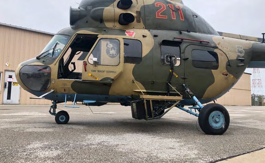
The FAA and University of Iowa Operator The University of Iowa Operator Performance Laboratory
flew trials in degraded visual environments with one of its
Performance Laboratory collect data on Mi-2 research helicopters in support of the FAA Technical
Degraded Visual Environment solutions with Center. (Images courtesy of OPL except as noted)
an eye to civil helicopter certification. on helmet-mounted and head-down displays (HMDs and HDDs).
The draft report combines data from the Mi-2 flights with previous
By Frank Colucci trials flown on the FAA’s S-76 Helicopter from 2016 to 2018.
Collaborative investigations into sensor field-of-view, effective
M
visual cues and other performance areas aim to help the FAA
ilitary rotorcraft solutions for Degraded Visual
Environments (DVE) integrate new sensors, pilot cues
and flight control laws. The US Army is testing DVE-
Mitigation (DVE-M) technologies on a Black Hawk, and the Air Force
is in a critical design review on a Degraded Visual Environment
System (DVES) for its Pave Hawk. For civil helicopters, the FAA
William J. Hughes Technical Center near Atlantic City, New Jersey,
continues to partner with academia and industry to test existing
sensor and display technology.
“Several companies are actively working on systems, and some
even have devices that are ready to purchase and are being
submitted for certification,” said FAA research engineer Cliff
Johnson. “I think that combined with the evolution in size, weight
May / June 2020
and power of fused sensors,” like infrared, millimeter wave
radar, and lidar, “and the power of head-worn/helmet-mounted
displays, we have all of the ingredients that the industry needs to
develop an effective and affordable DVE solution.”
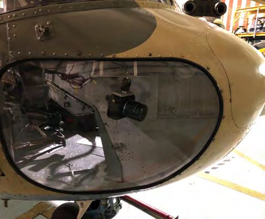
The FAA Tech Center teamed with the University of Iowa Operator A Sony UMC-S3C reference camera in the right chin
Performance Laboratory (OPL) last June to fly DVE approaches in a bubble provided visible light performance like the
Mil Mi-2 research helicopter and compare sensors and symbology human eye.
34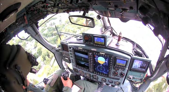
site miles away from the
                                                                                                            final approach fix and not
                                                                                                            necessarily aligned with the
                                                                                                            final approach course.” He
                                                                                                            added, “During approach and
                                                                                                            landing, it is not uncommon
                                                                                                            for a helicopter to raise
                                                                                                            its nose in order to slow
                                                                                                            down and come to a hover,
                                                                                                            or to turn its nose away in
                                                                                                            order to see the helipad
                                                                                                            environment.          However,
                                                                                                            unlike [a fixed-wing] flare
                                                                                                            when you are already at the
                                                                                                            runway environment or you
                                                                                                            see a flare-cue like you do
                                                                                                            with an EFVS, the helicopter
                                                                                                            flare-equivalent      happens
                                                                                                            prior to reaching the helipad.
                                                                                                            Fixed-wing aircraft land
                                                                                                            and slow down whereas
                                                                                                            helicopters slow down and
                                                                                                            land. The idea is that, taken
                                                                                                            together, these qualities in
                                                                                                            how helicopters fly could
  Comparative approach views by clear night (left) and foggy day (right) show natural and                   necessitate a wider field-of-
  synthetic vision views of the airport with conformal symbology.                                           view in both the lateral and
                                                                                                            vertical directions.”
offer guidance and shape policy and rules to use enhanced vision
technology under specific conditions. Johnson acknowledged,           Helicopters also require more complex pilot cues. Prof. Tom
“there are several operators who want to use the technology but       Schnell at the Iowa Technology Institute Operator Performance
don’t have a regulatory basis or adequate guidance to use the         Laboratory explained, “I think it’s primarily that you’re operating
technology to its fullest extent today.”                              the helicopter very close to the ground. If you’re in enroute, low-
                                                                      level mode in the helicopter, you have a lot more things to deal
The FAA already allows fixed-wing operators safety or operational     with like antennas, powerlines and so forth. You need to make
credits for enhanced flight vision systems (EFVS) under Title 14 of   3D conformal symbols for those.” Synthetic vision systems
the Code of Federal Regulations Part 91.176. According to Johnson,    turn three-dimensional data into intuitive displays to improve
“These systems provide what is known as ‘visual advantage,’           situational awareness. Conformal symbology paints synthetic
which helps to qualify how much of a landing credit on an             vision content on terrain and obstacles in the real world. Schnell
approach can be provided for a particular operation when using        added, “You’re dealing with a lot of clutter issues when you get
enhanced vision as part of an enhanced flight vision system....”      down close to the ground.”

Fixed-wing EFVS systems use head-up displays (HUDs) to show           While airliners or business jets are relatively easy to fly to the
pilots aircraft information, flight symbology and the real-time       end of a runway marked on a HUD, low-speed helicopters going
sensor image of the outside world. Though stationary HUDs             through translational lift close to the ground increase pilot
and forward-looking sensors may work in airplanes penetrating         workload. “Now you’re flying a machine that’s traditionally not
fog or other obscurants, helicopters have less cockpit space for      stable,” said Schnell. “I have a lot more dependency on good
fixed displays. Helmet displays and scanning sensors can show         cueing for pitch, roll and yaw and the translational axes that you
helicopter pilots enhanced vision system imagery, synthetic           wouldn’t have in a fixed-wing airplane.” He added, “Given that in
vision imagery and helicopter flight symbology synced to head         standard helicopters stability augmentation is not much or not at
movements via a head-tracker.                                         all, that’s harder to control.”

Most EFVS for fixed-wing aircraft use cooled or uncooled infrared     The OPL conducts human-in-the-loop research on synthetic
imagers, in some cases fused with visible light or other sensors.     vision and enhanced vision systems head-up and head-worn
According to Johnson, cooled IR sensors generally do a good job       displays optimized symbology. Human factors data from the
of imaging airport environments required under Part 91.176.           flight trials will shape systems requirements for certification. OPL
                                                                                                                                             May / June 2020

However, they can be limited in their ability to see through          is determining the effectiveness of lidar in detecting obstacles
maritime fog and image non-infrared LED lights. Rescue, medevac       for en route and landing zone evaluation under a range of
and law enforcement helicopters often fly into unprepared             environmental conditions.
landing zones without markings, exacerbating the differences.
                                                                      Trying Eyes
Johnson noted, “On top of that, due to helipads often being           An OPL pilot flew the Lab’s Mi-2 helicopter in desert brownout
located in obstacle-rich environments in urban or rural areas,        conditions at Yuma Proving Ground, Arizona, in 2016 during
typically steeper approaches are flown, often with the landing        DVE-M trials for the US Army and NATO. The helicopter carried a

                                                                                                                                             35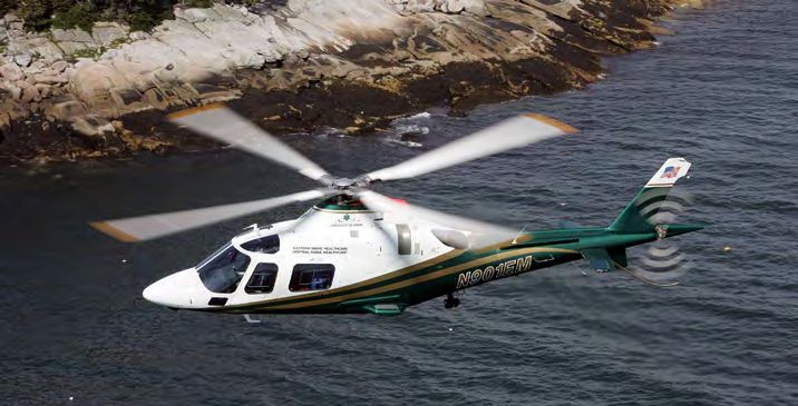
night and in the helmet display at night.
The color camera was modified to become
a monochrome sensor with nearly 5.5
million ISO sensitivity and a response in
the near-infrared region. Schnell offered,
“That camera, the ME20F, is an absolutely
amazing camera. In my opinion, every
helicopter should have one. It gets you
images at night at least as clear as
daytime.”
A Sony UMC-S3C camera in the right chin
bubble provided visible light performance
like the human eye. The CMOS camera was
fitted with a green filter with a spectral
transmission function like the human
photopic (color sensing cone cell) vision.
OPL software turned red-green-blue color
levels into calibrated luminance values.
“Therefore, we now have a 60 frames/
sec, very sensitive and accurate real-time
digital photometer. This helps when we
want to know how far you can see object
x-y-z; we need to know how bright it is.”
Researchers cropped the camera image
to make Hensoldt symbology conform
to real-world details. The lidar had both
a built-in geographic database and the
algorithms to determine that vertically
aligned returns meant there was a
tower. T-symbols used to represent
towers, for example, could come from
real-time sensor returns or the stored
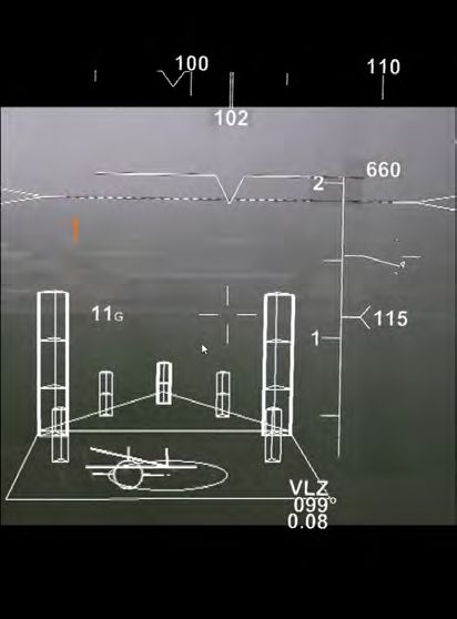
Night (top) and day (bottom) views of the OPL Mi-2 cockpit show the multifunction database. “If you have a database of
head-down displays of the Collins common avionics architecture system. objects, they’d show up and you would
not know the difference,” explained
Hensoldt SferiSense 500 lidar on a left-side outrigger. According to Schnell. “We don’t want to you to be concerned where they
the manufacturer, the active-scanning laser radar detects terrain come from — it’s a tower.”
and unspecified obstacles out to 0.75 miles (1,200 m). The lidar
was modified with dust-filtering software for the Yuma trials. OPL built an experimental helipad at the Iowa City Municipal
It generated color flight symbology on a BAE Systems Striker Airport using FAA engineering standards. Airport beacons,
II HMD and a HDD of the Collins Aerospace common avionics windsocks and other targets of interest selected by the FAA
architecture system (CAAS) in the test helicopter.
The Striker II head tracking system (see “Heads Up, Eyes Out,
All Around,” Vertiflite, Sept/Oct 2018) allowed symbology to be
projected on the helmet visor conforming to real-world terrain
and obstacles. The HDD superimposed symbology from the
lidar over short-wave infrared imagery generated by a Goodrich
short-wave infrared (SWIR) video camera and an ASI visible
light camera on the sensor outrigger. Head-up and head-down
displays could show the pilot different subsets of sensors and
data concurrently. Significantly, the Yuma test pilot preferred
a minimized, decluttered symbol set on the HMD and more
complete symbology on the HDD.
May / June 2020
The Striker II helmet was returned to the supplier after the
desert tests, but the same lidar was tied to a monochrome green
helmet display from SA Photonics and a new Hensoldt Optronics
head tracking system last year for the FAA investigation. A
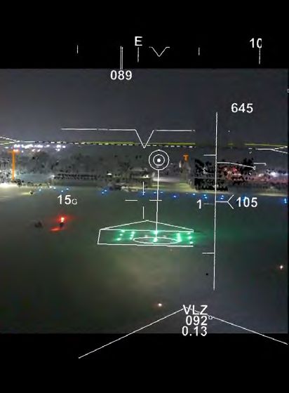
Canon ME20F-SH low-light video camera was installed in the View through the OPL helmet mounted display with all
left chin window and interfaced with the cockpit displays and sensors and symbology engaged shows “voxels” and
computers to provide background imagery in the HDD day and conformal symbology in a cluttered view.
36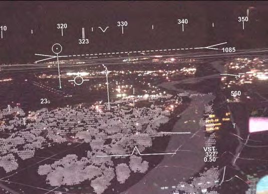
and feather-out to show less and less
                                                                                                  camera image.”

                                                                                                  Returns to Rules
                                                                                                  Civil DVE mitigation technologies can get
                                                                                                  certified via supplemental type certificates
                                                                                                  on existing helicopters, type certificates
                                                                                                  on new aircraft or with non-required
                                                                                                  safety enhancing equipment (NORSEE)
                                                                                                  approval. Cliff Johnson explained, “A
                                                                                                  system that is in the pilot’s primary field
                                                                                                  of view on a head-up display being used
                                                                                                  for operational credit would likely have
                                                                                                  different and higher certification and
                                                                                                  operational requirements to meet than a
                                                                                                  system used purely for enhancing safety.”
  The FAA and LifeFlight of Maine are working to make an enhanced vision system
  one part of an integrated low-level IFR approach, departure and route system.                For the FAA, the end-game of the research
  (LifeFlight of Maine)                                                                        is performance-based standards, policy
                                                                                               and guidance. According to Johnson,
were identified at the airport. Test pilots flew day and night          findings will be published and circulated within the FAA Tech
approaches to the helipad and an airport runway landing zone in         Center program office and among other stakeholders in the agency
unlimited visibility and in fog and light rain. They used different     including NextGen airspace, flight standards, aircraft certification
combinations of symbology, synthetic vision and enhanced                and the FAA’s Rotorcraft Standards Branch experts. Data will also
vision on both the head-up and head-down displays.                      go to the US Helicopter Safety Team (USHST) as it addresses a
                                                                        “Helicopter Safety Enhancement” (HSE-91) on vision systems
Target detection ranges and other data was collected using the OPL      technology. The FAA Tech Center program office also participates in
cognitive assessment tool set (CATS) that also recorded weather         industry working groups that will develop standards for enhanced
conditions from the airport automated surface observing system          vision technologies.
and flight state from the helicopter inertial navigation system. A
cockpit camera recorded imagery and symbology on the head-              The FAA is also collaborating with LifeFlight of Maine on a
down multi-function displays, and a helmet camera captured the          demonstration project to research an enhanced vision system as
HMD view with its real-time symbology.                                  one part of an integrated low-level instrument flight rules (IFR)
                                                                        approach, departure and route system covering the rugged state
Preliminary findings noted the Mi-2 test pilot liked the vision         and its islands. According to LifeFlight of Maine executive director
systems and appreciated the sensor enhancements more as                 Thomas Judge, “EVS is an important technology in a systems
visibility degraded. Researchers payed special attention to de-         approach to low-level IFR.” The fully integrated system would
cluttering helmet displays in the already-cluttered helicopter          enable helicopter pilots to reach more patients in areas where
environment. “You cannot just take a head-down symbology set            ceiling and visibility fall below required minima. “Incorporating
and shove it into a helmet,” said Schnell. “You can’t see through it.   EVS certified for approach credit will allow us to safely reduce
You can’t see the real world behind it.” Pilots did use both head-up    the required minima in lowered visibility conditions to our
and head-down displays to distinguish obstacles from clumps of          procedures while maintaining the highest level of safety and
“voxels,” or volume pixel returns. “As a pilot flying with an HMD,      situational awareness for our pilots.”
I would not put them in my face,” acknowledged Schnell. “But
when I pick up a tower, I take a quick glance at my head-down           Helicopter enhanced vision systems for degraded visual
display so I get trust in the lidar’s ability to detect an obstacle.”   environments have a growing technical foundation, and the
                                                                        FAA Tech Center’s Johnson concluded, “If we follow the path
With different sensors in play, experimenters confirmed visible-        that was taken for fixed-wing, utilizing lessons learned but
light cameras degrade just like the human eye in fog and rain.          respecting and acknowledging the differences and challenges
Infrared imagery penetrates obscurants to some extent and lidar         in rotorcraft, I believe we will develop a DVE solution for the
likewise provides some penetration. “There’s no magic bullet,”          civilian vertical lift community. That will help in reducing the
concluded Schnell. “About the only thing you can count on to            helicopter fatal accident rate and expanding efficiency
penetrate would be millimeter wave radar, which we didn’t have.”        for low-visibility approaches.”

OPL researchers plan further tests with an SA Photonics color
helmet display in place of the monochrome display. “It looks
                                                                            About the Author
                                                                                                                                                  May / June 2020

great,” observed Schnell. “We haven’t collected data.” Color
                                                                            Senior contributing editor Frank Colucci has written for
has long been used as a way to enhance cockpit warnings, and
                                                                            Vertiflite for the past 20+ years on a range of subjects, including
conformal color cues may help call out hazards. “I think even if
                                                                            rotorcraft design, civil and military operations, testing,
you had three colors, it would be good, maybe four. Having a lot
                                                                            advanced materials, and systems integration. He can be reached
more is probably not necessary.” Within the last few feet before
                                                                            at rotorfrank@aol.com.
touchdown, a helmet display might even turn itself off to clear
the landing zone. “I think there’s a lot more work to be done
where the helmet display might be aware of what your eyes see

                                                                                                                                                  37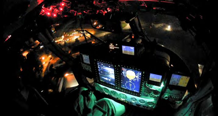
You can also read