Seismic risk assessment of Constantine City (Algeria)
←
→
Page content transcription
If your browser does not render page correctly, please read the page content below
Seismic risk assessment
of Constantine City (Algeria)

M. Boukri, M.N. Farsi, M. Belazougui, O. Amellal, N. Guessoum
National Centre of Earthquake Engineering, CGS, Algiers, Algeria

A. Mebarki
Université Paris-Est, LaboratoireModélisation et Simulation Multi Echelle, MSME, UMR
8208 CNRS, 5 Bd Descartes, 77454 Marne-La-Vallée, France

B. Mezazigh
Civil Engineering Dept, University of Boumerdes, Algeria

SUMMARY:
Located at the North-East of Algeria, Constantine has an important administrative, economic, scientific and
cultural position and knew a significant urban evolution during the different periods of its history. This city is
located in active seismicity area of Algeria and has been stricken in the past by several moderate to strong
earthquakes where the most recent took place on October 27th, 1985 with a magnitude Ms = 6.0. Because of its
dense housing and high concentration of population (2374 hab/km²), Constantine presents a very high seismic
risk which requires an assessment in order to take preventive measures to reduce losses in case of major event. In
this context an earthquake scenario was performed using the HAZUS methodology adapted to the Algerian
context and using a wide inventory of buildings built. The main results obtained from this scenario are presented
in this paper.

Keywords: Constantine, Seismic risk, Earthquake scenario

1. INTRODUCTION

Recent earthquakes (Chlef 1980, Constantine 1985, Oued Djer 1988, Tipaza 1989 Mascara 1994, Ain
Benian 1996 and more recently still Boumerdès 2003) (Yelles et al., 2003) show that there is an
important seismic activity in Algeria. This activity affects essentially the Northern part of the country
where the big cities are located for which the seismic risk is growing with the economic development
and population growth.

Protect a city against earthquakes is, first, trying to understand and know the situation which will
happen after the earthquake struck, which leads to the following questions: what will be the
appearance of the city after earthquake? How to deal with the disaster? How to organize relief? Can
limit losses? What should be done?

These questions can find answers after making scenarios with probable earthquakes that could hit an
urban area and its surroundings. The authorities of the city thus will have elements that will enable
them to know and to estimate the losses in advance, with an acceptable error, and to take the necessary
measures before (prevention by generalizing vulnerability studies), during (development of an
emergency plan with all the concerned sectors) and after (reconstruction) earthquake.

In this work, we propose to conduct a seismic scenario in Constantine city, see Fig. 1.1, which is
located in a zone of active seismicity of Algeria which was shaken by several moderate to strong
earthquakes, the last dates of October 27, 1985 (Ms = 6.0). Because of a high concentration of
economic, scientific, cultural infrastructures and population (2374 hab/km²) (RGPH 2008),
Constantine city requires special attention to protect it, in an acceptable level, against earthquake
which can strike at any time.
Constantine city experienced a significant urban change during the different periods of its history
(Boussouf, 2002). It knew the transit of many civilizations which each was marked by particular urban
development.
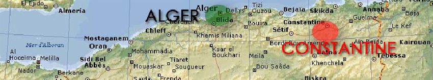
Figure 1.1: Location of the Constantine city map
This seismic scenario to estimate the probable seismic damages is done with a computer code that has
been developed for this purpose for the calculation and processing of all data to estimate the damages
and their spatial distribution. This computer code also allows to make a classification of constructions
according to five (05) degrees of damage, (D1: Negligible damage, D2: Slight, D3: Moderate, D4:
Extensive and D5: Complete) and thus identify the most affected areas by the earthquake.
2. SEISMIC DAMAGE ESTIMATION METHODOLOGY FOR BUILDING
The seismic damage estimation process for building which was used to perform the earthquake
scenario of Constantine city is based on the HAZUS approach (The FEMA Tool Estimating
Earthquake Losses) (FEMA, 2002) which uses the capacity spectrum method developed by several
research studies (Mahaney et al., 1993; ATC-40; 1996; Comartin et al, 1999; Chopra and Goël, 1999;
Fajfar, 1999). The main parameters are the seismic solicitation represented by a response spectrum and
the structure behavior represented by its capacity curve. The performance point, which is the
intersection of the capacity curve and the response spectrum, represents the behavior of the building
subjected to a given earthquake, see Fig. 2.1. This performance point allows to calculate the
probability of damage for each damage level according to its location on the fragility curves and
therefore describes the damage level of the structure.
Table 2.1: Buildings Types used in the methodology
Height (m)
NO. Typology Type of resisting system Stories
Name Number
1 RC1 - B Low rise 1-3
Reinforced Concrete Beam-
2 RC1 - M Medium rise 4-7
Columns Structures
3 RC1 - H High rise 8 and more
4 RC2 - B Low rise 1-3
Reinforced Concrete Shear Medium rise
5 RC2 - M 4-7
Walls
6 RC2 - H High rise 8 and more
7 S-B Low rise 1-3
8 S-M Steel Structures Medium rise 4-7
9 S-H High rise 8 and more
10 URM-B Unreinforced Masonry (Bearing Low rise 1 -2
11 URM - M walls) Medium rise 3 and more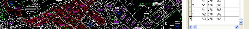
The building classification is based on the type of lateral resisting system, the number of stories (see
table 2.1) and the period of construction (table 3.1). We have considered the most common building
types defined in the Algerian Seismic Code (RPA99/Version 2003). These building types are
reinforced concrete, masonry and steel structures.
This classification is approximately consistent with the most existing classifications used by several
seismic damage estimation models in the world and particularly by HAZUS (FEMA, 2002) method.
Figure 2.1. Seismic damage estimation procedure
3. BUILDINGS INVENTORY OF CONSTANTINE CITY
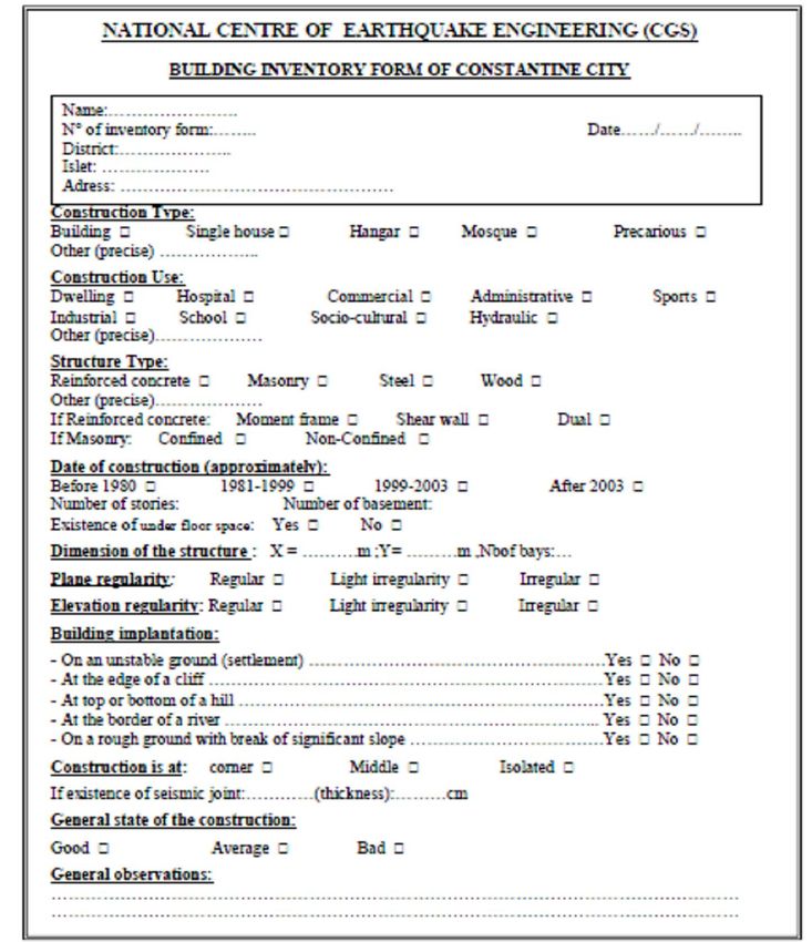
To apply the seismic scenario for estimating the probable building damage in Constantine city, an
inventory has been conducted in the study area using a form developed for this purpose, see Fig. 3.1.
This sheet contains all of the parameters that can have an influence on the seismic response of the
building (Boukri et al., 2008) according to its structural typology, period of construction, number of
stories, etc. The data collected have been stored in a digital database as illustrated in Fig. 3.2, then
each sheet has been associated with an entity "built" on the urban map of Constantine city, see Fig.
3.3.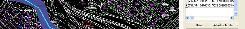
Figure 3.1. Building inventory form for Constantine city

Figure 3.2. Computer Code interface of Building inventory form
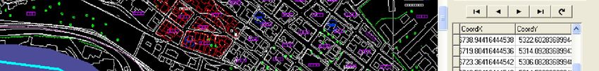
Figure 3.3. Example of building digitalization in Constantine city

The inventoried buildings have been also classified according to the updating periods of the Algerian
Seismic Code (see table 3.1)

Table 3. Seismic design levels according to evolution periods' of the Algerian seismic code (RPA)
  Code version           After 2003         1999–2003           1981-1999          Before 1981
    Code level           High-code        Moderate-code         Low-code            Pre-code

30706 constructions have been inventoried. Analysis of this data shows that masonry constructions
represent 12% (3712 construction) of the total identified buildings and is the part of the former City
(old rock site) and the sites around it built during the colonial period (before 1962). In terms of
structural typology, reinforced concrete constructions predominate (21186 units, 69%) divided
between frames and shear walls (19385; 63.13%, and 1801, 5.85%), this situation is explained by the
development of the city from 1930 using the Reinforced Concrete and the strong urbanization post-
independence. The steel frame structures represent about 5% (1589 constructions) and are mainly in
the industrial zone built the form of hangars and small industrial buildings and a few other hangars in
schools and educational institutions. Wooden structures are almost non-existent. There are other
typologies representing about 14% of the total of constructions divided between temporary
constructions made of sandwich panels conducted after the 1985 earthquake and precarious
constructions.

Most of the buildings (89%) are residential; the second part is academic institutions with 1068
constructions (3.48%). The rest of the buildings is divided between hospital, commercial, industrial,
administrative and socio-cultural (mosques, sport halls, etc.) occupancy. The number of constructions
built between 1980 and 2003 (13268; 43.21%) close approximately the number of buildings dating
from before 1980 (15893; 51.76%). This is mainly due to the strong urbanization from the 1980s. This
percentage is much lower for the period post 2003 (short period between 2004 and the date of the
Census as well as the lack of constructing sites in the study area). These structures are divided into
three categories according to the number of stories. Most are those of low height (1 to 3 stories)
represent 77%, constructions of average height (4 to 7 stories) are more than 22% of total buildings.
The number of high rise buildings (8 stories and more) is low (227; 0.74%) and represents housing
buildings.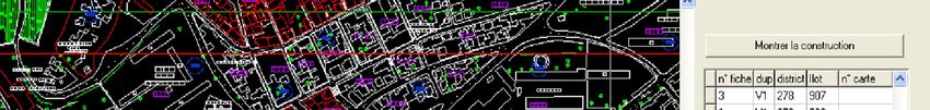
4. SEISMIC SCENARIO IN CONSTANTINE CITY:

4.1 Seismic Hazard

To estimate the maximum acceleration (PGA) at the bedrock, we took into account the results of the
seismic hazard study carried out in Constantine city (CGS, 2011b).The nearest fault which may affect
the city is Ain Smara fault with a maximum magnitude Mw 7±0.23.

Using the Ambraseys attenuation law represented by Eqn.4.1 below (Ambraseys et al., 2005),
considering a magnitude Mw = 7 and an average Epicentral distance of 4 Km, the calculation yields a
PGA in Constantine city of 0.45 g. The choice of this law (Eqn 4.1) is due to the fact that it was
established on the basis of 595 strong motion records from Europe and the Middle East including 3
records from Algeria caused by shallow crustal earthquakes with magnitudes Mw ≥5 and distance to
the surface projection of the fault less than 100 km.. This attenuation law is the best one to apply it to
Constantine context.

          log y = a 1 + a 2 M     W   + (a3 + a 4 M     W   ) log      d   2
                                                                               + a 52 + a 6 S S
                                                                                                      (4.1)
          + a7S    A   + a 8 F N + a 9 F T + a 10 F 0

Where: SS=1 for soft soil sites and 0 otherwise, SA=1 for stiff soil sites and 0 otherwise, FN=1 for
normal faulting earthquakes and 0 otherwise, FT=1 for thrust faulting earthquakes and 0 otherwise and
F0=1 for odd faulting earthquakes and 0 otherwise.a1 to a10: Coefficients derived for evaluation of the
horizontal peak ground acceleration and the spectral response acceleration for 5% damping.
d: Epicentral distance

4.2 Geotechnical Context

According to the study performed by the National Centre of Earthquake Engineering (CGS, 2011a),
analysis and interpretation of parameters from physical and mechanical tests performed on the
geological formations Constantine site, show that the urban area of Constantine city is classified S1
(Hard soil) according to the classification given by the Algerian Seismic Code updated in 2003
(RPA99/ 2003).

4.3 Response Spectrum for the Seismic Scenario

The seismic damage estimation methodology is applied using the elastic response spectrum (ζ = 5%)
of the Algerian Seismic Code (RPA99/2003) which is given by the following formula, Eqn 4.2:

              ì       æ       T ö                     0 £ T £ T1
              ï1.25 Açç1 + 1.5 ÷÷
              ï       è       T1 ø
              ï2.5(1.25 A)                            T1 £ T £ T2
          Sa ïï
            =í             æT ö
                                 2/3

          g ï2.5(1.25 A)ç 2 ÷
                           èT ø                       T2 £ T £ 3.0 s                              (4.2)
              ï
              ï            æT ö
                                 2/3   5/3
              ï2.5(1.25 A)ç 2 ÷ æç ö÷
                                     3
                                                      T ³ 3.0s
              ïî           è 3 ø èT ø

The developed computer code automatically generates the elastic response spectrum for 5% damping
in “Acceleration-Displacement” format of the studied site. The following parameters are taken into
consideration:
- Bedrock S1
- T1 = 0 15 s and T2 = 0 30 s
- Calculated site acceleration: A = 0. 45 g
4.4 Seismic Damage Estimation and Generation of Damage Maps
Inventoried buildings considered in this study (28486 among 30706 buildings) are classified according
to the following typologies: RC1 (20201), RC2 (1801), RDU (4910) and S (1574). The remaining
buildings (2220) no corresponding to any classification and are excluded from data. The seismic
damage probabilities of each type (see table 4.1) are estimated according to five (05) damage levels
(D1 to D5) and are spatially distributed. Each damage level is associated with a color (see table 4.2).
Table 4.1. Damage probabilities by typology for of Constantine city
Damage degree
D1 D2 D3 D4 D5
Typology
RC1 2.77% 18.53% 56.64% 16.86% 5.2%
RC2 0.21% 28.29% 52.28% 14.56% 4.66%
URM 0.02% 0.44% 42.38% 27.70% 29.46%
S 0.08% 18.45% 57.34% 17.57% 6.56%
Table 4.2.Associated colour to each damage degree.
Damage degree Colour
D1 Light green
D2 Dark green
D3 yellow
D4 Orange
D5 Red
The spatial distribution of the damages is done on the basis of the city map (subdivision of the city
into 10 sectors grouping 496 districts) adopted during the General Census of Population and Housing
of 2008 (RGPH, 2008). The damage ratio in the 10 sectors as well as the damage rate calculated
considering only Extensive damage (D4) and Complete damage (D5) are given in table 4.3 and Fig.
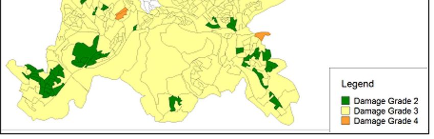
4.1. Generated damage maps, as illustrated in Figs 4.2 and 4.3, allow to locate the districts which
suffered the highest damage (damage D4 + D5 rate).
Figure 4.1. Total damage probabilities in Constantine city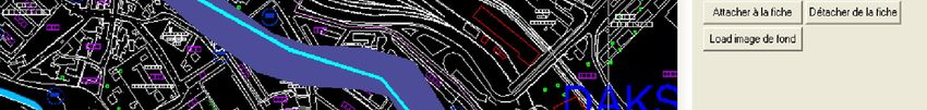
Table 4.3. Damage probabilities by sector in Constantine city
              Damage Level                                                                  Damage Ratio :
                               D1 (%)       D2 (%)      D3 (%)     D4 (%)       D5 (%)
Sector Name                                                                                  D4+D5 (%)
         Sidi M'cid              3.77        24.45       47.77      16.15        7.75            23.90
          Martyrs                1.76        13.84       56.65      19.45        8.29            27.75
         Boussouf                0.45        21.51       56.73      16.16        5.15            21.31
       Rock-old city             0.66        5.55        53.22      23.70        16.88           40.58
         University              0.80        8.96        64.44      19.26        6.53            25.79
     Djebel el Ouahch            2.69        21.03       56.97      14.62        4.69            19.31
    El Mansourah-SMK             1.61        11.54       51.75      20.72        14.38           35.10
           Daksi                 1.22        9.79        59.85      19.71        9.43            29.14
         Gammas                  3.93        25.91       48.93      15.30        5.93            21.23
      Industrial zone            2.13        20.97       52.33      17.84        6.73            24.57
        Total Area               1.99        16.02       53.95      18.62        9.42            28.04

                Figure 4.2: Average preponderant Damage level in districts of Constantine city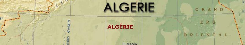
Figure 4.3: Damage ratio in each sector of Constantine city

5. CONCLUSION

A seismic scenario in Constantine city (Algeria) was presented. An important buildings inventory has
been carried out by the National Centre of Earthquake Engineering (CGS), 31000 buildings have been
inventoried and classified according to the lateral resisting system, occupancy, period of construction,
number of stories, etc. This study was performed using a seismic damage estimation methodology
developed on the basis of HAZUS approach. A computer code based on this methodology was
developed to estimate the damages and to generate damage maps.

The results of this seismic scenario in Constantine city highlight that the ratio of likely damage
(D4+D5) is approximately 28%. The higher damages are concentrated mainly in the sector of the old
city containing the districts of the Casbah, Coudiat and Belle-Vue, and the sectors of El Mansourah
and Sidi Mabrouk, where there is a concentration of old buildings.

These results may be overestimated, because we used as seismic event, in the absence of study area
response spectrum, the response spectrum of Algeria Seismic Code (RPA99/2003) which
overestimates the level of seismic hazard.

AKCNOWLEDGEMENT
A part of the building inventory of Constantine city and data acquisition was carried out by the engineers
belonging to the CGS office at Constantine: Boukal, I., Souki, E., Bouaoud, M., Fettar, B.
REFERENCES

Ambraseys, N. N., Douglas, J., Sarma, S. K., and Smit, P. M. (2005). Equations for the estimation of strong
     ground motions from shallow crustal earthquakes using data from Europe and the Middle East: horizontal
     peak ground acceleration and spectral acceleration.Bulletin of Earthquake Engineering, Springer, 3: pp 1–
     53 DOI 10.1007/s10518-005-0183-0.
ATC-40.(1996). Seismic Evaluation and Retrofit of Concrete Buildings, Vol. 1, Applied Technology Council,
     Redwood City, California.
Boukri, M.,and Bensaïbi, M. (2008). Vulnerability index Algiers masonry buildings. Proceedings of the 14th
     World Conference on Earthquake Engineering, Beijing, China.
Boussouf, R. (2002). Constantine : D’une ville attractive à une ville répulsive, Laboratoire d’Aménagement du
     territoire, Université de Constantine, Algérie.
CGS (2011a).Seismic Microzonation Study of Urban Areas in Constantine City,Earthquake Engineering
     Research Centre, CGS.
CGS.(2011b). Seismic Hazard Study of Urban Areas in Constantine City, Earthquake Engineering Research
     Centre, CGS, 2011b.
Chopra, A. K., and Goël, R.K..(1999). Capacity Demand Diagram Methods Based on Inelastic Design
     Spectrum.Earthquake Spectra, N° 15.
Comartin, C., Niewiarowski, R., Freeman, S. A., and Turner, F. (2000).Seismic Evaluation and Retrofit of
     Concrete Buildings: A practical Overview of the ATC 40 Document. Earthquake Spectra, N° 16.
Fajfar, P.(1999). Capacity Spectrum Methods Based on Inelastic Demand Spectra. Earthquake Engineering and
     Structural Dynamics.N° 28.
FEMA.:HAZUS99. (2002). Earthquake Loss Estimation Methodology. Technical Manual., Federal Emergency
     Management Agency , Washington, DC, United States.
Grünthal,G., and Levret, A. (2001). European Macroseismic Scale1998. Cahiers du Centre Européen de
     Géodynamique et de Séismologie, Vol.19, 103pp., Luxembourg.
Mahaney, J. A., Terrence F. P., Bryan E. K., and Sigmund A. F. (1993). The Capacity Spectrum Method for
     Evaluating Structural Response during the Loma Prieta Earthquake.Proceedings of the 1993 United States
     National Earthquake Conference, Memphis, Tennessee.Vol.2, Pages 501-510, 1993.
RGPH. (2008). Recensement Général de la Population et de l’habitat, Office National des Statistiques, Algérie.
RèglesParasismiqueAlgériennes, RPA99 modifiées en 2003. (2004). DTR-B.C.2.48, Ministère de l’habitat et de
l’urbanisme, Algérie.
Yelles-Chaouche, A. K..(2003). Recent Seismic Activity in Northern ALGERIA.Proceedings of the Fourth
     International Conference of Earthquake Engineering and Seismology, Tehran, Islamic Republic of Iran.
You can also read