Settlement, Communication and Exchange around the Western Carpathians in European Context - International Workshop at the Institute of ...
←
→
Page content transcription
If your browser does not render page correctly, please read the page content below
Settlement, Communication and Exchange
         around the Western Carpathians
                    in European Context
                            International Workshop
                    at the Institute of Archaeology,
                  Jagiellonian University in Kraków
                              October 27–28, 2012
Workshop outline

Since 2006 the Department of Archaeology, University of Kraków, and the Department of
Archaeological Sciences, University of Bochum, run a joint archaeological project on
Neolithic and Bronze Age settlement patterns in the middle part of the Dunajec river valley in
Little Poland.

Based on data from the archaeological survey of Poland (AZP) a long-term perspective is
taken on the development and change of human settlement in this micro-region. Intensive
survey work is carried out, including geomagnetics and intensive fieldwalking, to verify and
improve the often very broad dating of sites known since AZP; large-scale excavations on
the extensive hilltop-settlement of Janowice aimed to provide an improved pottery
chronology that is supported by absolute dates from scientific dating methods and give us
some impression of the internal dynamics of this unusual settlement type; trial excavations
on a number of surrounding sites aimed to clarify the chronological and functional
relationship of these smaller settlement units to the ‘central’ place of Janowice. GIS
applications are used to integrate the spatial data obtained and model long-term change in
settlement patterns in the micro-region examined.

It is asked, for example, for what reasons there was a marked change in settlement activity
from the hilltops during the Neolithic towards the slopes of the Dunajec valley in the Bronze
Age. In what sense was the hilltop-settlement of Janowice with its long history of occupation
from broadly the Middle Bronze Age to the Early Iron Age ‘central’ for this development in
sociopolitical terms, mind older debates on fortified Lusatian hilltop sites presumably
accomodating some kind of Bronze Age elites, or rather as a focus of local identities that
developed over centuries and saw a combination of long-lived sites representing the stable
element of human presence in this marginal landscape opposite shorter-lived places.

For marginal the Dunajec valley is, when compared to the fertile Loess soils in the lowlands
along the Vistuala river. The micro-region under study is situated in the foothills of the
Western Carpathians, an area of great interest in current research for its role as a mediator
of contact and exchange with communities further south in the Carpathian Basin. Such
contacts are evident already in the Neolithic when there is exchange in stone and flint raw
materials. Even more so in the Bronze Age when further east with the Otomani communities
of the Jasło group there is more or less clear evidence for the presence of a ‘foreign’
population. The situation in the Dunajec valley is different, however, since the foreign
element is much less marked, for example in our pottery assemblages. Hence this region
may help to come to a more differentiated modelling of trans-Carpathian contacts in
prehistory.

The workshop will present some results of our ongoing project work, and colleagues are
invited working on related subjects to discuss our findings in a wider European context.
A publication of the papers held on the workshop is planed in BAR International Series.

In order to allow representatives of various disciplines the opportunity to participate the
presentations should not exceed 20 minutes. In addition there will be 10 minutes allowed for
discussion following each paper. The conference is funded by the Alexander von Humboldt-
Foundation. There is funding for accomodation and adequate travel expenses for non-local
participants. The number of participants will be limited but additional papers may be included
in the publication of the conference proceedings

Sections / topics proposed:

Western Carpathians and Dunajec valley – Archaeological and topographic setting

Neolithic settlement, communication and exchange around the Western Carpathians

Bronze Age settlement, communication and exchange around the Western Carpathians

Methods and theory: Modelling spatial patterning in settlement systems and communication
(including GIS applications)

Organising Comitee

Prof. Dr. Paweł Valde-Nowak (University of Kraków)

Prof. Dr. Tobias L. Kienlin (University of Bochum)

Marta Korczyńska M. A. (University of Bochum/Kraków)

Klaus Cappenberg (University of Leipzig)
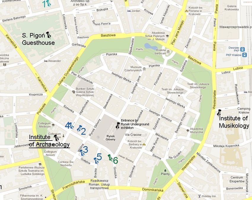
Friday, October 26th

Arrival of participants

17.00–19.00        Registration and welcome at the conference venue:

                   Instytut Archeologii Uniwersytetu Jagiellońskiego /
                   Institute of Archaeology Jagiellonian University
                   ul. Gołębia 11/ Gołębia str. 11
                   31-007 Kraków

20.30–22.00        Opportunity for a joint tour - Rynek Underground permanent exhibition:
                   “Following the Traces of European Identity of Kraków” of the participants

Saturday, October 27th
(presentations of 20 minutes plus 10 minutes for discussion)

08.30–9.30         Registration and welcome at the conference venue:

                   Instytut Archeologii Uniwersytetu Jagiellońskiego /
                   Institute of Archaeology Jagiellonian University
                   ul. Gołębia 11/ Gołębia str. 11
                   31-007 Kraków

9.30–10.00         Pawel Valde-Nowak (Kraków) / Tobias L. Kienlin (Bochum): Welcome and
                   Introduction

Section I: Western Carpathians and Dunajec Valley – Archaeological and Topographic
Setting

10.00–10.30        Peter Bogucki (Princeton): The Western Carpathian Highlands during the
                   Neolithic
10.30–11.00 Wojciech Blajer (Kraków): Die Westkarpaten als Kontaktzone in der
Bronzezeit aufgrund der Hort- und Einzelfunde der Metallgegenstände
11.00–11.30 Coffe break
11.30–12.00 Madgalena Moskal-del Hoyo / Maria Lityńska-Zając / Katarzyna Cywa
(Kraków): Plant Remains Found in Archaeological Sites in the Carpathian
Foothills - Preliminary Report
12.00–12.30 Michał Wasilewski (Kraków): Stones collecting and preliminary
discrimination on the archaeological site - Janowice (AZP 106-65 no. 61)
case study
12.30–14.00 Lunch break
Section II: Neolithic
14.00–14.30 Paweł Valde-Nowak (Kraków) / Klaus Cappenberg (Leipzig): Long houses
on hilltops, the camps in the mountains. Some aspects of the Neolithic in
the Dunajec project
14.30–15.00 Andrzej Pelisiak (Rzeszów): Settlement, Economy and Climate between
3200 and 2500 BC. Late Neolithic Transformations in South-East Poland
15.00–15.30 Marek Nowak (Kraków): Settlement and economic transformations in
western Little Poland around 3000 BC: internal development vs external
implantation
15.30–16.00 Coffee break16.00–16.30 Agnieszka Czekaj-Zastawny / Anna Rauba-Bukowska (Kraków):
Technology of the Oldest Vessels in the Upper Vistula River Basin –
Imports against Local Pottery
16.30–17.00 Agnieszka Czekaj-Zastawny (Kraków) / Jacek Kabaciński (Poznań) /
Thomas Terberger (Greifswald): Cultural relations between the Great
Hungarian Plain and the southern Baltic coast. Imports from the
Bodrogkeresztúr Culture on the site Dąbki 9 (Middle Pomerania)
17.00–17.30 Harald Stäuble et al. (Dresden): One Too Many Settlements: BK-Eythra In
the Context of Northwest-Saxony, Germany
17.30–18.00 Andreas Zimmermann (Köln): Patterns of Landuse Between Neolithic and
Roman times in western Germany - a diachronic comparison
19.00– Opportunity for a joint dinner of the participants
Sunday, October 28th
Section III: Bronze Age
9.30–10.00 Marta Korczyńska (Kraków) / Tobias L. Kienlin (Bochum): Vorläufige
Ergebnisse und methodische Überlegungen zur spätbronze- und
früheisenzeitlichen Besiedlung im mittleren Dunajectal / Preliminary Results
and Some Methodological Considerations on the Late Bronze Age and
Early Iron Settlement Organisation in the Middle Dunajec Valley
10.00–10.30 Anita Szczepanek (Kraków): Preliminary Results of the Anthropological
Analysis of Human Bones from Janowice (AZP 106-65 no. 103)
10.30–11.00 Coffee break11.00–11.30 Łukasz Oleszczak / Ireneusz Miraś / Łukasz Mrówka (Kraków): The
Carpathian Influences on the Bronze Age Settlement in Wierzchosławice
11.30-12.00 Marcin S. Przybyła / Magdalena Skoneczna (Kraków): Early and Middle
Bronze Age fortified settlement at Maszkowice (Western Carpathians).
Preliminary results of the new excavation campaigns (2010-2012)
12.00–13.30 Lunch break
13.30–14.00 Stephan-Karl Möllmann (Schwerin): Landscape Archaeology and GIS in
Upper Lusatia in the Late Bronze Age
14.00–14.30 Tobias L. Kienlin (Bochum) / Liviu Marta (Satu Mare): New Geophysical
Data on the Internal Structure of the Gáva Sites of Andrid-Corlat and
Căuaş-Sighetiu in North-Western Romania
14.30–15.00 Coffee break
15.00–15.30 Jozef Bátora / Peter Toth (Bratislava): Ein Beitrag zu den
Siedlungsstrategien der frühen Bronzezeit im Gebiet der SW-Slowakei
15.30–16.00 Klára Pusztainé Fischl (Miskolc): Bronzezeitliche Siedlungsstruktur im
Hernád Tal und in der Borsoder Ebene. Modelle und neue Forschungen /
Bronze Age settlement structures in the Hernád-valley and Borsod Plane.
Models and new researches
16.00–16.30 Concluding DiscussionPub for opening meeting (Friday, October 26th, 17.00 – )1
1. Zaginiony Świat (Entrance from the backyard)
Batrego str. 1
Kraków
(Reservation of the “Slavic Room”)
Suggested restaurants for a lunch brake:
2. Chimera - Salad Bar, vegetarian cuisine, św. Anny str. 3
3. Bordo - Restaurant, Pub Café, fusion cuisine, Gołębia str. 3
4. Trattoria Soprano - Restaurant, italian cuisine, św. Anny str. 7
5. CK Dezerter - Restaurant, galician cuisine, Bracka str. 6
Restaurant for a dinner meeting (Saturday, October 27th, 19.00 – )
6. Marmolada - traditional polish and italian cuisine
Grodzka str. 5
Kraków
(reservation of the “Fireplace Room”; meal costs not covered)
1
At 20.30 opportunity for a joint tour - Rynek Underground permanent exhibition: “Following the
Traces of European Identity of Kraków” with an english-speaking Guide.Peter Bogucki (Princeton): The Western Carpathian Highlands During the Neolithic The purpose of this paper is to situate prehistoric societies in and around the western Carpathian highlands during the sixth through third millennia B.C. in the grand narrative of European prehistory. Mountainous regions are typically viewed as barriers that were avoided, even feared, by Neolithic peoples, but discoveries such as the Iceman in the Alps indicate that they could be familiar with high uplands, even if they chose to reside at lower elevations. Thus highlands like the western Carpathians should not be not blank spots on the archaeological map but rather regions in which prehistoric human activity was quick, ephemeral, specialized, and purposive. Moreover, we see that the more luminous regions of Neolithic settlement to the north and the south have much in common, so the mountains and uplands must have been permeable for human interaction, even during the Neolithic. Understanding the prehistoric developments on either side of the Carpathian highlands thus requires examination of the interplay between local innovation and long-distance encounters. Wojciech Blajer (Kraków): Die Westkarpaten als Kontaktzone in der Bronzezeit aufgrund der Hort- und Einzelfunde der Metallgegenstände Im Zuflußraum der oberen Weichsel sind manche Bronzehort- und -einzelfunde bekannt, die aus den Stufen BzB1 bis HaB2/3 stammen. Einen Teil der Gegenstände (vor allem Ringschmuck und Tüllenbeile) bilden Importe aus den südlich der Westkarpaten gelegenen Gebieten. Eine typologische und chronologische Übersicht erlaubt die wichtigsten Verbindungen zwischen verschiedenen Regionen beiderseits von den Westkarpaten festzustellen, wobei abwechselnde Tendenzen sichtbar sind. Daraus kann man auch Schlussfolgerungen über die Bedeutung einzelner Flußtäler und Gebirgspässe als Kommunikationswege ziehen. Madgalena Moskal-del Hoyo / Maria Lityńska-Zając / Katarzyna Cywa (Kraków): Plant Remains Found in Archaeological Sites in the Carpathian Foothills - Preliminary Report New archaeological excavations have been conducted within the framework of a project concerning Neolithic and Bronze Age settlement patterns in the central part of the Dunajec river valley in the Little Poland region. These field campaigns have constituted a great opportunity for carrying out the first systematic archaeobotanical studies of this area. These studies have been aimed at qualitatively and quantitatively analyzing the plant macro- remains found in five archaeological sites, which represent the Neolithic Linear Band Pottery (LBK) culture (Łoniowa, Żerków and Gwoździec) and the Lusatian culture, belonging to the Bronze Age (Janowice and Wróblowice). New archaeobotanical data have offered palaeoethnographic information concerning the type of plants available and how they were employed by prehistoric cultures. Simultaneously, it has been possible to obtain significant palaeoenvironmental information including the history of plants in the region, the characterization of plant communities that were growing in the vicinity of human settlements
in different chronological periods and an indication of human impact on local ecosystems
during their occupation.

The applied methodology was of great importance in archaeobotanical analyses and
therefore, the research is based on representative samples taken from different
archaeological features and from various layers within each feature. Botanical materials were
identified taxonomically by using a reflected light microscope and a stereomicroscope. The
botanical material was divided into three groups, which provided important data concerning
the interactions between people and their environment.

(A) The first group includes cultivated plants, which are found mostly in the form of
macroscopic remains of plants or as plant imprints on daub. Their analysis provides valuable
ethnoarchaeological data related to the ancient diet of the inhabitants of the Neolithic and
Bronze Age settlements as well as they may help to characterize past crop husbandry
practices.

(B) The second group includes wild plants, which may also provide palaeoethnographic
information about the different uses of plants in the past. For example, a gathering of wild
fruits may be important supplementary information about a former food. On the other hand,
wild plants may be associated with other intentionally used plants. The presence of weeds
found within the crop assemblage constitutes an excellent example, and their identification
brings a series of data on habitat conditions in the areas nearby the settlements.

(C) The remains of wood constitute the last group and among them the most common are
charcoals. This archaeobotanical material gives evidence of a former knowledge about the
usage of wood as a raw material as well as it indicates the strategies of forest management
in the past, giving mostly palaeoethnographic information. Anthracological research also
allows environmental interpretation through an attempt to reconstruct the ancient forest
communities. In the case of archaeological features representing the first stage of
neolithisation in the region, it is also possible to infer the composition and the character of
primeval forests.

Paweł Valde-Nowak (Kraków) / Klaus Cappenberg (Leipzig): Long houses on hilltops,
the camps in the mountains. Some aspects of the Neolithic in the Dunajec project

Some years of excavations on sites in the area of watershed in between Uszwica and
Dunajcec rivers in Polish Carpathians, have resulted in documenting Neolithic sequence of
occupation of the Wiśnicz Foothills central part by Linear Band Pottery and Malice culture
communities.

As it is commonly known the Linearbandkeramik is to occupy low landscape forms, terraces
of small rivers and streams, whereas, in the Polish Carpathians (Wiśnicz Foothill) rather
deep into the Foothill zone, a group of early agricultural settlements with long houses was
discovered and what is interesting, all these settlements are located on tops of elevations. In
one of these houses, distinguished by its enormous dimensions (41,5 m long) a grave
equipped with a flint set and clay bowl was recognized. Most probably another grave
discovered by the western wall of the house in this same situation, but not equipped so rich
can be considered. It may be assumed that this house fulfilled a special function in that
community – it may have been a meeting place, and the person buried there may have been
an eminent, especially distinguished person in that group (senior or priest). Considering the
mentioned facts from a larger point of view this mysterious discovery refutes the myth of low
locations, typical of, as it is said, Linearbandkeramik in whole Europe from the basin of the
Danube to the Netherlands.

Thank to the latest researches an important observations can be preliminary raised. They are
the early Neolithic short settled sites located in mountainous landscapes unexpectedly much
lower. The topography of early Neolithic stray finds, known from Jaroszowice and Dąbrówka
in Middle Beskidy Mountains, in contrast to the high situated permanent occupied villages in
Wiśnicz Foothills zone, is connect with slopes of semi-leveled mounds. The settlement-
geographical analysis of both variants has been done during the Dunajec Project, realized by
a ‘conventional’ Site Catchment Analysis to compare the possible settlement environments of
both areas potentially pointing to differences concerning land use and duration of the early
Neolithic settlements. The exploitation zone of each site has been simulated by a Path
Distance algorithm to include non-euclidean impacts provided by the landform of both
regions. Different factors concerning relief, soil and hydrology have been collected and their
classified content area has been compared.

Andrzej Pelisiak (Rzeszów): Settlement, Economy and Climate between 3200 and 2500
BC. Late Neolithic Transformations in South-East Poland

Significant changes of human activity (settlement patterns, economy, social organization) in
south-east Poland took place between ca 3200 and 2500 BC. Sedentary way of life has been
gradually replaced by mobile husbandry and pastoralism. Moreover, for a first time during the
Neolithic high zones of landscape (between 400 and 800 m above see level and up to 1200
m a.s.l.) were used. Exploitation of mountains is also confirmed by palynological data from
this area, but there are no evidences of human activity in mountains earlier.

One of the important questions of prehistoric research is where, when and to what extend
climate was influential factor in changes of human way of life. Results of the archaeological
and palaeogeographical investigations curried out during last years in south-east Poland can
be strong ground of the discussion on these problems. This area consists of the several
ecological zones: lowland, loess uplands, Carpathian Foothills and mountains (Lower Beskid
Mts. and Bieszczady Mts.). Regarding to this area archaeological database consists of more
the 10 000 sites dated from ca 5300 BC (Linear Pottery Culture) to ca 1600 BC (Early
Bronze Age Mierzanowice culture) including settlement sites, burial mounds and single finds.
The Holocene history of vegetation changes and evidences of human activity comes from
pollen analysis of the deposits from several palaeobotanical sites located within all above
mentioned zones.

Settlement, economic and cultural changes in south-east Poland are connected with
transformations of much wider geographical extend. I would like to discuss the questions
which climatic events and to what extend could they stimulated cultural and economic
changes. This paper will be dedicated to the Late Neolithic of SE Poland but I will especially
focused my attention on the East Polish Carpathians including Foothills and Lower Beskid
Mts. and Bieszczady Mts.
Marek Nowak (Kraków): Settlement and economic transformations in western Little
Poland around 3000 BC: internal development vs external implantation

In the late fourth and early third millennia BC in western Lesser Poland a unique mixture of
different archaeological traditions is clearly visible. Local archaeological units, belonging to
several Central European systems of information flow (the Funnel Beaker culture, the Baden
culture, the Corded Ware culture) seem to overlap in great measure, both chronologically
and territorially. Important cultural changes are evidenced as well, mainly in settlement and
economy, but probably also in ideological and social spheres. In the presentation I will argue
that these changes, on the one hand, reflect the general patterns seen in the Central
European cultural development during that period, but on the other hand, they have their own
local, specific aspect. The prehistoric and anthropological interpretation of the simultaneous
functioning of several archaeological phenomena in the same area will be also the topic of
this presentation.

Agnieszka Czekaj-Zastawny / Anna Rauba-Bukowska (Kraków): Technology of the
Oldest Vessels in the Upper Vistula River Basin – Imports against Local Pottery

The authors of the paper since 2011 realize (in IAE PAN) the NCN grant (N N109 181 040),
entitled: Technology and chronology of the oldest pottery in the upper Vistula River basin
(VI/V millennium BC). The project consists of two components, i.e. research on the
technology of ceramics and absolute chronology of stylistic phases of the Linear Pottery
Culture (14C dating). The objective is to define a framework of internal periodization of this
culture, in the upper Vistula River basin, i.e., connection of the evolution of vessels style with
the results of 14C dating and detailed tracing of patterns in the technology of the pottery in
various phases of culture development.

Technological analyzes are carried out on series of pottery samples, in order to examine the
relationship between morphology and technology of their production, the primary function of
the various forms and noticing of chronological and territorial differences. Mineralogical-
petrographic and physic-chemical analysis aimed at reconstructing of the manufacturing
process of ceramics, such as sourcing and selection of materials, preparation and
composition of the pottery mass, methods of making and firing, as well as to determine their
physical properties and purpose.

All analyzes are carried out successively, and in that paper will be presented some
preliminary results relating to the comparison of pottery technology of the Linear Pottery
Culture in the upper Vistula basin with pottery imported from the area of the Eastern Linear
Pottery circle.

Agnieszka Czekaj-Zastawny (Kraków) / Jacek Kabaciński (Poznań) / Thomas Terberger
(Greifswald): Cultural relations between the Great Hungarian Plain and the southern
Baltic coast. Imports from the Bodrogkeresztúr Culture on the site Dąbki 9 (Middle
Pomerania)

Around 5600-5500 calBC first farmers appeared at the North European Lowland initiating ca.
2.000 years lasting process of neolithisation of this area. Obviously, on such a vast territory a
dynamic of this process was diversified due to several factors where demographic and
economic potential of hunters-gatherers and first farmers played a basic role. Cultural
relations between these so different societies in the course of neolithisation and effects of
those relations were and still remain a crucial research issue. Numerous arguments
documenting long-lasting character of those relations provide site Dąbki 9. A unique feature
of Dąbki settlement is the presence of several horizons of imports in the Late Mesolithic and
early FBC context, mainly pottery vessels. These imports point toward an important role of
that place in the exchange system between Mesolithic groups inhabited Central European
Lowland and Neolithic people. Beside local hunters-gatherers, groups of Linear Band
Pottery, Stroke Band Pottery, Ertebølle, Brześć Kujawski Group, Funnel Beaker and finally
Bodrogkeresztúr cultures were engaged in these contacts. Till 2009 on site 9 at Dąbki there
were discovered 8 potsherds of the Bodrogkeresztúr culture. Ornamentation, morphology,
and technology of the fragments are typical for the pottery of the culture in question. In the
light of the newest evidences the beginning of the Bodrogkeresztúr culture should be placed
a few centuries earlier (ca. 4300 calBC). In that case we can synchronize the discussed
imports with the earliest Funnel Beaker settlement stage in Dąbki, i.e. with years 4100/4000
calBC. Interpretation of interactions observed on the site is difficult. Considering the fact that
Bodrogkeresztúr communities were very mobile and maintained long-distance contacts,
pottery fragments from Dąbki may testify their penetrations of southern Baltic coasts for
trading with local hunting-gathering groups. These groups maintained broad multidirectional
contacts from the very beginning of the settlement on the Dąbki site, dated to ca. 4900/4800
calBC. At that moment there appeared first imports from the Danubian cultural milieu (Linear
Pottery, Stroked Band Pottery, Lengyel). The long-distance contact were maintained during
the settlement stage linked with the Funnel Beaker culture, still of the haunting-fishing-
gathering character. They also reached the areas of the Carpathian Basin, more than a
thousand kilometers away.

Andreas Zimmermann (Köln): Patterns of Landuse Between Neolithic and Roman
times in western Germany - a diachronic comparison

Land use seems to be firstly determined by environmental conditions. In fact lithosphere,
pedosphere, hydrosphere, biosphere and atmosphere seem to be most influential. In the last
years the atmosphere with its climate system for example is discussed as a cause for cultural
disintegration in the case of the end of early Neolithic Bandkeramik in western Germany. It
will be critically discussed if these arguments are convincing. With farming economy
pedosphere with the focus on soil becomes an important factor. However, with farming
techniques already a factor of the cultural system is involved in land use patterns. Relief of
land surface as an aspect of lithology has important impact on precipitation and is without
doubt an environmental forcing for farming societies concerning land use. Nevertheless after
the Ice Age and in temperate environments, it can be shown that cultural development and
cultural cycles are factors for land use patterns equal ranking with environment.
Marta Korczyńska (Kraków) / Tobias L. Kienlin (Bochum): Vorläufige Ergebnisse und
methodische Überlegungen zur spätbronze- und früheisenzeitlichen Besiedlung im
mittleren Dunajectal / Preliminary Results and Some Methodological Considerations
on the Late Bronze Age and Early Iron Settlement Organisation in the Middle Dunajec
Valley

In this paper we report on systematic survey work on Bronze Age sites in the middle part of
the Dunajec river valley, Little Poland. For some years now, excavations have been carried
out on the site of Janowice AZP 106-65 no. 61. The survey work in the surroundings aims to
establish the chronological and – if possible – functional relation of adjacent sites to the north
and south of the hilltop site of Janowice that has a long tradition of settlement during the
Bronze and Early Iron Ages. Amongst others we report on systematic surface survey work
and geomagnetic prospection carried out on AZP 106-65 no. 57, a site only a little distance
downhill from no. 61, on sites such as AZP 106-65 nos. 70-75 and 103 towards the north in
the Lubinka valley, and on a number of sites south of Janowice no. 61 in the Zakliczyn basin
and adjacent foothills further south (e.g. AZP 107-65 nos. 75 and 83). From this intensive
survey work, that aims at a complete coverage and verification of sites previously reported by
AZP, an increasingly better understanding of the dynamics of a (Late) Bronze Age to Early
Iron Age microregion is beginning to emerge. From a methodological point of view it is
asked, for example, how the pottery inventories from recent fieldwalking compare to the older
finds from the archaeological survey of Poland (AZP). Furthermore methodological aspects
are discussed arising from the comparison of spatial patterning in the surface finds compared
to geomagnetical anomalies and targeted test excavations.

Anita Szczepanek (Kraków): Preliminary Results of the Anthropological Analysis of
Human Bones from Janowice (AZP 106-65 no. 103)

Preliminary anthropological analysis concerns 17 features. Determinations of age at the
moment of death and sex of individuals were performed on the basis of preserved elements
of skeleton with reference to anatomical and morphological criteria, commonly accepted in
anthropology, regarding specifications for burnt bones. Due to anthropological analysis it was
evaluated that the features contained remains of 18 individuals. Only in one grave there were
buried 2 individuals: an adult and a child. Most of individuals were determined as adults, but
remains of 4 children there were also found. The bones were strongly and evenly burnt, of
colour from grey-white to creamy white, which indicates that the temperature of funeral pyre
was within a range of 600–800°C.

Łukasz Oleszczak / Ireneusz Miraś / Łukasz Mrówka (Kraków): The Carpathian
Influences on the Bronze Age Settlement in Wierzchosławice

The archaeological site 15 at Wierzchosławice, Tarnów district (north-western Małopolska),
is situated within the floodplain of the Dunajec River, ca 1.5 km from the present-day
riverbed. First traces of permanent occupation are represented by materials associated with
Transcarpathian cultures of the Early and Middle Bronze Age. These groups most likely
came here from the territory of eastern Slovakia or borderlands between Slovakia and
Hungary, and represented several taxonomic units developing in that region, such as the
Piliny culture, Berkesz-Demecser culture, and Suciu de Sus culture of Slovakia. Initially, they
established contacts with the representatives of the Trzciniec culture from Kraków region,
perhaps playing the intermediary role in the transmission of Transcarpathian elements to
local milieu, and next with the ‘post-Trzciniec’ groups from Rzeszów Foothills and southern
parts of Kolbuszowa Plateau. ‘Transcarpathian’ settlement at Wierzchosławice came to an
end in BrD, perhaps as a result of some violent event, maybe a fire. ‘Transcarpathian’
occupation at Wierzchosławice was followed by a hiatus period, and the site remained
unsettled for ca 200 years. It was probably not before HaB1/HaB2 that the next group of
settlers appeared – this time representing the Lusatian culture population. From that moment
on, the settlement was inhabited permanently until HaD.

Two occupational phases connected with the Lusatian culture may be distinguished at
Wierzchosławice. To the first phase, apart from the artefacts dating to the final Bronze Age,
one should also include the materials from the transition between the Bronze Age and Early
Iron Age (starting from HaB1/B2, through periods HaB2 and HaB3, until HaC). To the
second, younger phase one can include the finds dating to the end of the Hallstatt period
(HaD).

The attribution of the Wierzchosławice settlement to a particular unit within the Lusatian
culture is not unambiguous. There are finds typical of the Tarnobrzeska group, and of the
Górnośląsko-małopolska group. However, the most apparent are connections with the
Carpathian zone, and with a specific local variant of the Lusatian culture developing there.
There are also numerous analogies to Transcarpathian cultures from Slovakia, and to East-
European cultures such as the Cozia-Saharna culture or the Chernoles culture.

Marcin S. Przybyła / Magdalena Skoneczna (Kraków): Early and Middle Bronze Age
fortified settlement at Maszkowice (Western Carpathians). Preliminary results of the
new excavation campaigns (2010-2012)

The settlement at Maszkowice is one of the best preserved long-lasting occupied prehistoric
sites in the Western Carpathians. Particularly interesting is the first settlement phase of the
hillfort, which may be dated to the end of the Early Bronze Age and to the Middle Bronze Age
(ca. 1650-1200 BC). Results of studies on materials collected during the field research of M.
Cabalska (seasons 1959-1975), as well as new excavation campaigns (2010-2012), allow us
to formulate some conclusions concerning: settlement stratigraphy, spatial distribution of
EBA-MBA materials, chronology of the subsequent building phases and cultural connections
of the populations living in the upper Dunajec Valley during the earlier periods of the Bronze
Age. In the context of last mentioned question particularly worth the attention are relics of
fortifications in a form of a dray stone wall, discovered in 2011-2012 and connected with the
oldest building phase of the hillfort (ca. 1650-1500 BC).
Stephan-Karl Möllmann (Schwerin): Landscape Archaeology and GIS in Upper Lusatia
in the Late Bronze Age

Der Vortrag wird eine kurze Zusammenfassung meiner Magisterarbeit aus dem Jahre 2008
mit dem Titel „ Die Besiedlungsgeschichte in der Späten Bronzezeit im Gebiet um Bautzen in
der Oberlausitz/Sachsen – Eine landschaftsarchäologische Untersuchung mit Hilfe von GIS“
im Fach Ur- und Frühgeschichte an der Universität Leipzig wiedergeben. Hauptaugenmerk
lege ich dabei auf das GIS als Werkzeug in der Landschaftsarchäologie und werde nur auf
einige spezielle Ergebnisse der Untersuchung eingehen. Zuerst erfolgt eine kleine Einleitung
und Begriffserläuterung zur Landschaftsarchäologie und GIS. Dann wird das
Untersuchungsgebiet in der Oberlausitz vorgestellt, welches einen kurzen Abriss über
Geologie, Bodenkunde, Gewässernetz und Klima beinhaltet. Daran soll erläutert werden
warum sich gerade dieses Untersuchungsareal für die Arbeit mit dem GIS anbietet. Danach
werden die bearbeiteten naturräumlichen Faktoren (Höhenlage, Hangausrichtung,
Bodenartkartierung und Entfernung zum nächsten Fließgewässer) beschrieben, sowie kurz
die Möglichkeit weiterer Analysen und die Übertragbarkeit rezenter Ökofaktoren in die
vorgeschichtliche Zeit erläutert. In gleicher Weise erfolgt eine kleine Einleitung über die
prähistorische Besiedlung in der späten Bronzezeit in der Oberlausitz, sowie eine Auswahl
von Ergebnissen. Am Ende folgt eine Abhandlung über Vorteile und Grenzen bei der Arbeit
mit dem GIS.

Landscapearchaeology and GIS in Upper Lusatia in the Late Bronze Age:

-      introduction and definition of landscapearchaeology and GIS

-      area of examination in Upper Lusatia

-       summary in geology, soil science/pedology, system of rivers/hydrology and climate –
suitable area for working with GIS

-       factors for environment (altitude, direction of slope, area and type of soil and distance
to the next river), another possibility of analysis and transfer of recent factors of ecology into
prehistoric

-      overview in settlement of late bronze age in upper Lusatia and selection of results

-      GIS as a tool in landscapearchaeology – possibilities and constrictions

Tobias L. Kienlin (Bochum) / Liviu Marta (Satu Mare): New Geophysical Data on the
Internal Structure of the Gáva Sites of Andrid-Corlat and Căuaş-Sighetiu in North-
Western Romania

With its dense occupation and the good preservation of its sites the Ier valley in north-
western Romania offers ideal conditions for the study of long-term trends in Bronze Age
land-use and settlement organisation. By means of aerial photography, geophysical survey
and intensive archaeological survey important data on the spatial organisation of prehistoric
settlement activity both on the intra-site and on the off-site level can be obtained. Based on
such intensive survey techniques a joint project of the Muzeul Judetean Satu Mare and the
Institut für Archäologische Wissenschaften, Ruhr-Universität Bochum, seeks to develop a
better understanding of the dynamics and the development of Bronze Age settlement
patterns in Ier valley. In the long-run an increasingly closer coverage of the Early to Middle
and Late Bronze Age sites of the Ier valley micro-region is aimed at. So far, in five survey
campaigns the fortified settlements of the Late Bronze Age Gáva culture at Căuaş-Sighetiu
(Sziget in Hungarian) and at Andrid-Corlat (Korlát in Hungarian) as well as a number of tell
sites of the local Early to Middle Bronze Age were examined. In this paper we want to focus
on the Late Bronze Age situation, more specifically on the fortified sites of Căuaş-Sighetiu
and Andrid-Corlat that seem to have dominated the Urnfield period landscape in the upper
part of the Ier valley. We will focus specifically on aspects of the spatial organisation of the
settlement remains at Căuaş-Sighetiu and Andrid-Corlat. New magnetometer data is
available that allows for the first time a comparison of the intensity of habitation at both sites
and of the internal organisation of the Late Bronze Age settlements at Căuaş-Sighetiu and
Andrid-Corlat.

Klára Pusztainé Fischl (Miskolc): Bronzezeitliche Siedlungsstrukturen im Hernád Tal
und in der Borsoder Ebene. Modelle und neue Forschungen / Bronze Age settlement
structures in the Hernád-valley and Borsod Plane. Models and new researches

In dem Vortrag werden die Siedlungsstrategien der RA1 zeitlichen Hatvan- und RA2
zeitlichen Füzesabony-Kultur in zwei zusammenhängenden Mikroregionen vorgestellt: im
Hernád Tal und auf der Borsoder Ebene. Anhand neuer Forschungsergebnisse möchte ich
die Ähnlichkeiten und Abweichungen zwischen den zwei Perioden diskutieren. Anhand der
siedlungsarchäologischen Daten werde die Rolle des Hernád Flusses, die möglichen
Existenzstrategien und gesellschaftliche Modelle verschiedener Regionen versucht zu
klären. In Bezug auf das Hernád Tal werde ich kurz auf seine Lage und Bedeutung in
Netzwerken für Fernhandelskontakte eingehen.
You can also read