Severe Weather adaptation - COASTAL RESILIENCY COUNTY CASE STUDIES VOLUME 2 November 2014
←
→
Page content transcription
If your browser does not render page correctly, please read the page content below

Severe Weather adaptation
COASTAL RESILIENCY COUNTY CASE STUDIES • VOLUME 2

 November 2014

severe weather adaptation
COASTAL RESILIENCY COUNTY CASE STUDIES • VOLUME 2

Overview
    Extreme weather events such as heat waves, floods, increased rainfall and superstorms are propelling
    communities to reevaluate and strengthen their current hazard mitigation plans. In 2011 alone, weather
    disaster damages cost the U.S. over $35 billion.1 When faced with the threat of weather impacts,
    the risk management choices are broadly the same: resistance, accommodation, avoidance, transfer
    and acceptance. The case studies in this publication explore three counties’ approaches to reducing
    vulnerability and exposure using planning, technology and collaboration tools.

Case studies
    MONMOUTH COUNTY,                                MONTEREY COUNTY,                               CALVERT COUNTY,
    NEW JERSEY                                      CALIFORNIA                                     MARYLAND
1     “Overview”. Climate Communication Science and Outreach. 2014. www.climatecommunication.org/new/articles/extreme-weather/overview/

     November 2014
Monmouth County, New Jersey

Community Rating System Assistance Program
          The northernmost county along the Jersey shore, Monmouth County
          lies within the New York metropolitan area and is home to approximately
          630,000 inhabitants, with the majority of the population living within five
          miles of the coast.2 In 2011, Monmouth County was heavily impacted by
          Tropical Storm Irene and, according to a Rutgers University study, endured
          more community hardship than all other New Jersey counties when it was
          hit again by Hurricane Sandy in 2012.3 Municipal damage in Monmouth
          County after Sandy was measured at $113 per capita of Federal Emergency
          Management Agency (FEMA) Public Assistance, which was nearly double
          that of the second highest FEMA Public Assistance recipient in New Jersey
          that year (Ocean County at $68 per capita).4

      2     “U.S. Census 2010”. U.S. Census Bureau. 2010. www.census.gov/2010/census/
      3     Monmouth County, N.J. scored 84 out of 100 on the community hardship index. “The Impact of Superstorm Sandy on New Jersey Towns and Households”.
            Stephanie Hoopes Halpin PhD, Rutgers School of Public Affairs and Administration. 2013. http://goo.gl/t45iKb
      4     Ibid.

       INTRODUCTION TO COMMUNITY RATING SYSTEM
       The Federal Emergency Management Agency (FEMA)’s National Flood Insurance Program (NFIP)
       runs a voluntary Community Rating System (CRS), which is designed to help communities discount
       local flood insurance premium rates by engaging in floodplain management techniques that exceed
       minimum NFIP requirements. The goals of the CRS are to reduce flood damage to insurable property,
       strengthen and support the insurance aspects of the NFIP and encourage a comprehensive approach
       to floodplain management. Categories of creditable activities include public information, mapping,
       regulations, flood damage reduction and flood preparedness. To learn more or to enroll your community
       in the CRS program, please take a look at the National Flood Insurance Program Community Rating
       System Brochure, located at http://bit.ly/1twcFLE.

       Source: “National Flood Insurance Program Community Rating System”. FEMA, NFIP. 2014. http://1.usa.gov/1tDUIIR

NOVEMBER 2014 • NATIONAL ASSOCIATION OF COUNTIES • COASTAL COUNTY RESILIENCY: SEVERE WEATHER ADAPTATION                                                        3
THE CHALLENGE
        Given its history and future risk of severe weather, Monmouth County recognized the importance of engaging its
        municipalities in flood hazard mitigation options. While New Jersey’s building requirements are stricter than NFIP
        minimum standards, which means every municipality is already eligible for advanced points in the CRS program
        (see box on previous page), municipalities were often unable to implement the CRS program on their own, given a
        lack of technical, financial and administrative capacity to navigate the CRS process. When the Biggert-Waters Act
        was signed into law in 2012 (which in some cases would have pushed flood insurance premiums up to $30,000
        for property owners), Monmouth County saw it as an imperative to move forward with the CRS Assistance
        Program.5 “[Lowering flood insurance premiums] was a need we could help accommodate,” said Joe Barris,
        Assistant Director of Monmouth County Division of Planning.

        THE PROJECT
        Monmouth County created the CRS Assistance Program early in 2014 to serve as a CRS planning and support
        system for all its municipalities. The goals of this program are to increase the use of the NFIP CRS program
        among Monmouth County municipalities by providing information and technical assistance. Monmouth County
        set out to build knowledge of the program among municipal officials and professional staff, assist municipalities
        in implementing the program and develop a peer learning forum to promote information exchange among
        participating communities.

        Initially, Monmouth County conducted outreach with mayors, clerks and department heads of all municipalities,
        explaining the CRS Assistance Program and why the municipalities’ participation was important. The county
        created municipal program participation guidelines and convened internal meetings attended by county
        department heads to achieve program buy-in. Providing towns with mapping services was particularly important,
        as the county was able to create open space and base flood elevation Global Information Systems (GIS) map
        templates so that CRS maps required for one town could easily be replicated for other towns. As this project falls
        under the purview of Monmouth County Planning Division’s organizational mission, there was no additional cost
        incurred to provide these services to municipalities.

    5     The Biggert-Waters Act of 2012 mandated that the NFIP charge actuarial rates, resulting in a large rate increase for consumers. Postal, Arthur D. “WYO
          Insurers: Carefully Consider NFIP Rate Changes to Avoid More Consumer Confusion”. Nov 20, 2013. Property Casualty 360.com

          Since Biggert-Waters was passed by Congress in 2012, the Grimm-Waters Act amended the Biggert-Waters Act to provide flood insurance premium caps of
          18% on individual properties, or 5-15% based on flood zone. Other amendments also apply. “Summary of Provisions that will Most Affect Property Owners:
          Homeowner and Flood Insurance Affordability Act of 2013 AKA Grimm-Waters 2013.” Hulst, Shannon. March 2014. http://goo.gl/mfc0ZX

4                                       NOVEMBER 2014 • NATIONAL ASSOCIATION OF COUNTIES • COASTAL COUNTY RESILIENCY: SEVERE WEATHER ADAPTATION
THE OUTCOMES
        Since March 2014, Monmouth County’s CRS Assistance Program has resulted in a number of positive
        outcomes, including:

                 •   Awareness of the CRS program has increased dramatically; only eight of Monmouth County’s 53
                     municipalities were participating in the CRS program before the CRS Assistance Program began, and
                     now approximately half of the municipalities are either actively participating in CRS or have shown
                     interest in becoming a CRS community.
                 •   A regional approach and use of a single point of contact for CRS assessors at the Federal level has
                     increased consistency.
                 •   Mapping templates helped towns earn additional points during their initial evaluations. Information and
                     resources on CRS can be easily retrieved through a new countywide CRS webpage.
                 •   An online library was created to catalogue best practices and FEMA-required documents.
                 •   A newly formed CRS user group holds quarterly meetings which encourage communal brainstorming
                     and peer mentorship.
                 •   County staff attend municipal meetings, promoting more efficient interaction between municipal and
                     county representatives. Municipalities have a streamlined process to request assistance, and county
                     staff can ask questions directly to municipal and state representatives in attendance.
                 •   Due to increased awareness of hazard mitigation, support for similar projects will be easier in the
                     future. The county views this as an investment in helping towns offset future costs by saving the policy
                     holders money on flood insurance premiums.

              The water line from flooding in Sea Bright, N.J. during Hurricane Sandy can still be seen on
              the front of the house pictured in the center of this photo. The house to the right has been
              elevated above this line to decrease flood risk in the future.

                                                        Photo Credit: Brittany Ashman, Monmouth County Division of Planning

NOVEMBER 2014 • NATIONAL ASSOCIATION OF COUNTIES • COASTAL COUNTY RESILIENCY: SEVERE WEATHER ADAPTATION                         5
THE LESSONS LEARNED
    Barris outlined three keys to Monmouth’s successful implementation of the program:

           1.   First, the Monmouth County Division of Planning took steps to ensure that heads of other departments
                within Monmouth County were on board with offering the CRS Assistance Program, and that they had
                a solid understanding of what CRS is and how their department could help provide assistance. This
                was arranged by holding internal training sessions.
           2.   The county developed municipal participation program guidelines so that program expectations at
                both the county and local level are clear.
           3.   The county found that the user group provides a tremendous amount of peer-to-peer support, and
                several municipalities may not have adopted CRS without it.

    Additionally, the county found that incorporating input from all involved members strengthened the program’s
    chances of success. For instance, at the request of one town, the CRS Assistance Program established
    standardized formatting for legal agreements to simultaneously reduce filing fees and meet county clerk filing
    requirements. The county’s pre-existing unified building code, which counted toward uniform minimum CRS
    credits, also helped the project succeed. Finally, the county found that increased public outreach was critical to
    achieving greater outcomes. For instance, FEMA requirements were posted in local libraries and a CRS presence
    was added to the Monmouth County website. The online CRS component was available for public review and
    was accessible to each town via a direct link, and both the CRS online presence and the library posting increased
    both public awareness and CRS credits.

         A new townhouse
         development in
         Belmar, N.J. is raised
         to reduce flood risk.

                                                   Photo Credit: Brittany Ashman, Monmouth County Division of Planning

6                           NOVEMBER 2014 • NATIONAL ASSOCIATION OF COUNTIES • COASTAL COUNTY RESILIENCY: SEVERE WEATHER ADAPTATION
Monterey County, California

Multijurisdictional Hazard Mitigation Plan Update
          A large county on the central coast of California, Monterey County’s
          population hovers near 415,000 citizens.6 Monterey County is home to
          the Salinas River Valley, also known as the “salad bowl of the nation,”
          because it produces a majority of America’s lettuce, artichokes, berries
          and other produce. The adjacent Monterey Bay National Marine Sanctuary,
          also known as the “Serengeti of the sea,” boasts Southern sea otters, more
          than 12 species of whales and dolphins, several species of seals and sea lions,
          dozens of species of seabirds, over 300 species of fish and a vast array of marine
          invertebrates.7 These and many other natural and cultural attractions mean that
          coastal tourism and recreation accounts for approximately 85 percent of the county’s
          ocean-based economic sectors.8

          THE CHALLENGE
          The county completed a hazard mitigation plan in 2007 including 11 of the 12 local municipalities.
          The plan addressed coastal erosion, dam failure, earthquakes, floods, landslides, hazardous material events,
          tsunamis, wild fires and windstorms. Since the plan was produced, Monterey County has experienced 41 natural
          hazard events that directly contributed to over $32 million in damages according to the National Oceanic and
          Atmospheric Administration (NOAA)’s National Climatic Data Center.9 In addition, California experienced seven
          inches of sea level rise between 1900 and 2005 and expects a minimum 55 inches of sea level rise by 2100, which
          will further coastal erosion, exacerbate saltwater intrusion and increase vulnerability to flooding and infrastructure
          damage.10 These changes could increase local temperatures, alter precipitation, threaten biodiversity, increase
          public health threats and thereby threaten agricultural productivity and tourism.11

      6     “U.S. Census 2010”. U.S. Census Bureau. 2010. www.census.gov/2010/census/
      7     “Monterey Bay National Marine Sanctuary”. The Encyclopedia of Earth. 2014. www.eoearth.org/view/article/154679/
      8     ENOW Explorer, 2011 Monterey County Calif. www.csc.noaa.gov/enow/explorer/
      9     “Monterey County Multijurisdictional Hazard Mitigation Plan 2013-2014 Update” Darrin Punchard. Nov 20, 2013. http://goo.gl/DiX2UE
      10    Ibid.
      11    Christensen, et al. “Chapter 14: Climate Phenomena and their relevance for Future Regional Climate Change,” Intergovernmental Panel on Climate Change
            2013. http://goo.gl/s4wVNt

NOVEMBER 2014 • NATIONAL ASSOCIATION OF COUNTIES • COASTAL COUNTY RESILIENCY: SEVERE WEATHER ADAPTATION                                                             7
THE PROJECT
     In an effort to consider recent and ongoing vulnerabilities, apply new available data and to remain eligible for
     FEMA assistance, in 2013 Monterey County and its 12 municipalities worked together with the help of AECOM
     to create an updated Multijurisdictional Hazard Mitigation Plan, completed in 2014.12 Resources from the NOAA
     Coastal Services Center’s Digital Coast platform helped shape the planning process and aided with the update
     to the county’s risk assessment. The goals of this updated plan are to promote disaster resilience and climate
     adaptation strategies by retrofitting and reinforcing existing community assets, encouraging natural systems
     protection, increasing public education and awareness and increasing local governmental capacity for disaster
     resiliency by facilitating coordination among stakeholders.

     Public outreach and stakeholder engagement were critical to the planning process. For instance, during the
     capability assessment (an exercise in ground-truthing goals with actual abilities), public meetings in multiple
     locations, participatory mapping exercises and an online survey were conducted. A detailed project website and
     project factsheet were also integral tools for outreach. The public meetings were so successful that additional
     meetings were scheduled in order to get more feedback and share the project with a larger audience.

     THE OUTCOMES
     The updated hazard mitigation plan includes an enhanced mitigation strategy section. Using Digital Coast throughout
     the entire planning process enhanced each participating jurisdictions’ capabilities. Further, by examining funding,
     staff capacity, technical strengths and limitations, political will and what had been accomplished in the previous
     five years, communities were able to assess their capabilities realistically and include specific, achievable actions
     in their plans. These principles are expected to carry through the entire plan life cycle between local adoption of
     the plan this fall and the next five-year plan update.

    12   AECOM is an infrastructure and support services firm. www.aecom.com

    INTRODUCTION TO DIGITAL COAST TOOLS
    Digital Coast is an enabling platform developed by NOAA to help communities address coastal issues by offering
    data, tools, trainings and case studies. NACo serves as one of Digital Coast’s founding partners. “While the data
    are not ‘official,’ per say, they are definitive, and all stakeholders were satisfied with the integrity of those credible
    geospatial data,” says lead AECOM liaison to Monterey County, Mike Robinson. More than ten data sets were
    used from Digital Coast, including bathymetry, elevation, land cover and socioeconomic data sets. Several tools
    were also used, including visualization tools like CanVis and the Sea Level Rise and Coastal Flooding Impacts
    Viewer, as well as economic data tools like the ENOW Explorer (all available at www.csc.noaa.gov/digitalcoast). In
    addition to using these data and tools from Digital Coast to help create the updated Multijurisdictional Hazard
    Mitigation Plan, Monterey County hosted a popular half-day Digital Coast training for local officials who had
    learned about the resource during planning meetings.

8                                    NOVEMBER 2014 • NATIONAL ASSOCIATION OF COUNTIES • COASTAL COUNTY RESILIENCY: SEVERE WEATHER ADAPTATION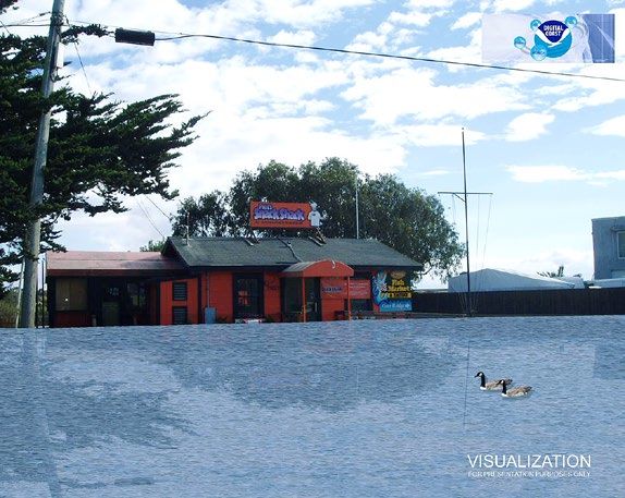
While climate change was not added as a new stand-alone hazard, the county acknowledged its impacts on
        those hazards that were originally mentioned, especially drought and wildfire, both of which could have significant
        detrimental effects on Monterey County’s agriculture and tourism industries. These impacts were incorporated
        into the updated plan, along with the newly identified threats of sea level rise and agricultural emergencies.

        In order to keep the plan regularly updated, sustained processes for maintaining the plan itself were established.
        These included utilizing and sharing GIS and electronic documents to better manage information, tracking local
        flood-related projects, continuing FEMA NFIP CRS program involvement and improving consistency between
        other regulatory programs and planning tools.13

      13   “Monterey County Multijurisdictional Hazard Mitigation Plan 2013-2014 Update” Punchard, Robinson, and Chang. Feb 6, 2014. http://goo.gl/bNCR2Z

               Several sites within the
               Monterey County planning
               area were selected for photo
               visualizations using the Digital
               Coast CanVis program. This
               free software helps illustrate
               the potential impacts of future
               development and hazard
               occurrences on a specific area,
               such as the potential effects of
               sea level rise on a recognized
               local landmark.

                                                                                  Photo Credit: AECOM, NOAA Digital Coast CanVis Program

NOVEMBER 2014 • NATIONAL ASSOCIATION OF COUNTIES • COASTAL COUNTY RESILIENCY: SEVERE WEATHER ADAPTATION                                                     9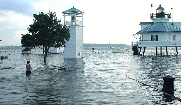
THE LESSONS LEARNED
      Because Monterey County was refining a pre-existing plan, it was able to hone in on specific details at a more
      granular level. For example, the county utilized the lidar data sets available on Digital Coast, which are more
      resolute than the data sets the county had on hand. Therefore, risk levels were able to be assessed more
      accurately, even down to the individual property level (i.e., looking at risk at the parcel and building footprint level).
      Whether or not risk levels changed when compared with the previous plan, stakeholders appreciated the more
      precise assessment. Digital Coast was thus crucial for providing data and tools that influenced the precision of
      the plan in ways that would not have been possible had Monterey County had to collect and pay for all the data
      and development of the tools themselves.

      Stakeholder involvement was another important component of the update process. Robinson said, “We had one
      big meeting, a mitigation strategy workshop, where we invited a large number of stakeholders to be involved, and
      it was so helpful that we did it again and expanded the number of invitees. This is how we were able to gather
      information we wouldn’t have known about otherwise. They were opportunities for collective knowledge sharing-
      -it gets everyone on the same page.”14

     14   Personal Communication, Aug 5, 2014.

             Members of the Monterey County Hazard Mitigation Planning Team, along with
             representatives from NOAA, FEMA and other stakeholder groups, discuss mitigation
             strategies following a presentation on hazard risks and local capabilities to address
             those risks.

                                                                                                         Photo Credit: AECOM

10                                   NOVEMBER 2014 • NATIONAL ASSOCIATION OF COUNTIES • COASTAL COUNTY RESILIENCY: SEVERE WEATHER ADAPTATION
Calvert County, Maryland
Community Flood Mitigation Efforts
Calvert County lies on the western shore of the Chesapeake Bay with a
population of approximately 89,000.15 Like many counties in the Chesapeake
Bay area, Calvert County deals with regular flooding. In addition to low-lying
coastland and daily tides, the land is subsiding (sinking), while over the past
20 years, sea levels have risen three to four times faster in various Chesapeake
Bay and Mid-Atlantic locations than the average global sea rise rate.16 Storm surge
from Hurricane Isabel in 2003 measured more than seven feet in some areas, significantly
flooding many communities.
THE CHALLENGE
Calvert County coastal residents live with the daily threat of tidal fluctuation and flooding. For instance, of 175 total
residential structures in Cove Point, 166 structures are flood-prone. The communities here routinely help each
other during bad floods and remind one another to park upland during normal high tides. Some citizens’ houses
are less than a few feet away from current base high tide levels, so when heavy rains or storm surge accompanies
the tide, flooding is expected. Though the local population is accustomed to flooding, they recognize that floods
have become worse and more frequent. While they don’t feel inclined to move away from the shore, they do
recognize the benefit of elevating houses to better accommodate the shift in tide levels.
THE PROJECT
Calvert County has a flood mitigation plan in effect for the entire county, but two communities, Cove Point and
Broomes Island, flood more regularly than other areas. Calvert County began a pilot project in 2014 to focus
on floodplain management in these communities. An important part of this effort includes elevating several of
the most vulnerable structures in Cove Point. Because flooding is an accepted part of the local culture, the
county’s main goal is to communicate with local residents and planners about increasing hazard impacts and the
availability of varied flood mitigation resources. This has been achieved through initiatives like trainings to help
visualize the impacts of sea level rise and sharing Army Corps of Engineers’ graphics depicting 100 and 500 year
flood events and hurricane impacts. “A large part of our success,” says Tay Harris, Environmental Planner of the
Calvert County Department of Community Planning and Building, “has been working closely with the Maryland
Department of Natural Resources and FEMA to build networking opportunities. The hands-on approach they’ve
shared with us, and our collective synergy, has been key.”
15 “U.S. Census 2010”. U.S. Census Bureau. 2010. www.census.gov/2010/census/
16 “Updating Maryland’s Sea-level Rise Projections”. Scientific and Technical Working Group Maryland Climate Change Commission. June 26, 2013.
http://goo.gl/uBYxqt
NOVEMBER 2014 • NATIONAL ASSOCIATION OF COUNTIES • COASTAL COUNTY RESILIENCY: SEVERE WEATHER ADAPTATION 11In addition to the pilot projects in Broomes Island and Cove Point, Calvert County has been building an online,
interactive shoreline development tool aimed at property owners. A user enters an address and answers several
questions which prompts the website to produce a GIS map of all local, state and federal permits that the user’s
proposed land development or building project will trigger. While this resource is not specific for flood elevation
projects, the website includes habitat jurisdictions, cultural preservation limitations, sea level rise information and
CRS and flood insurance information.
THE OUTCOMES
Seven of the most vulnerable houses in Cove Point, Broomes Island and nearby North Beach are being elevated
through Calvert County’s efforts.17 One uninhabited structure in Broomes Island has been acquired for demolition
with help from FEMA Predisaster Mitigation Grant funds; flanking wetlands will be allowed to migrate into the
property. In addition, water and sewer connection is being investigated for Cove Point, which experiences salt water
intrusion and failing septic systems. Furthermore, the communities are learning more about the changing nature
of flood insurance due to the Biggert-Waters Flood Act and the benefits of FEMA’s NFIP CSR program, and the
impacts of current and future sea level rise. “Residents in both floodplain communities know that we’re here to help
them deal with flooding,” said Harris.18
THE LESSONS LEARNED
In small communities like Calvert County, the county may be most supportive by listening to community needs, offering
support and being an active partner in pooling resources with state and federal agencies to address problems. In
this case, says Harris, “the Maryland Department of Natural Resources deserves a lot of credit for the success of our
communities’ flood mitigation efforts. Their office has been instrumental in reaching out to us to see what our needs
were and how they could best help.”19 By leveraging this resource and paying close attention to the needs of the
communities, Calvert County has been able to work on several separate but related flood mitigation strategies.
17 “Calvert County developing flood plans for Cove Point, Broomes Island”. Fleischman, Sarah. Southern Maryland Newspapers Online. May 28, 2014.
http://goo.gl/PJuuij
18 Personal Communication. Aug 7, 2014.
19 Ibid.
Flooding after Hurricane
Irene (2003) across the
Chesapeake Bay in nearby
Talbot County, MD.
Photo Credit: Chesapeake Bay Maritime Museum
12 NOVEMBER 2014 • NATIONAL ASSOCIATION OF COUNTIES • COASTAL COUNTY RESILIENCY: SEVERE WEATHER ADAPTATIONOn the left, the Calvert County community of Broomes Island is seen, outlined in yellow. In
the center, Broomes Island wetlands and the causeway to the community’s point and the
mainland are outlined in yellow. On the right, floodplain inundation of a 100-year flood is
shown in pink, with the limit of moderate wave action (LiMWA) indicated by the black line with
triangles. Note that the causeway is entirely flooded and isolates a portion of the community.
Photo Credit: Calvert County Department of Community Planning and Building
NOVEMBER 2014 • NATIONAL ASSOCIATION OF COUNTIES • COASTAL COUNTY RESILIENCY: SEVERE WEATHER ADAPTATION 13CONCLUSION
Every county has a different catalyst for addressing severe weather changes. For some, the impetus may be an
acute scenario such as a disaster requiring an urgent response, such as Hurricane Sandy in Monmouth County.
For others, motivation to address such issues might be due to chronic threats, like Calvert County’s daily flooding
events that make flood-prevention infrastructure and plans even more important when faced with additional
severe weather or sea level rise. Whether shocks or ongoing stressors are the motivating factor for addressing
these issues, a county’s resilience increases with each new iteration of hazard mitigation planning efforts, as
Monterey County showed.
Each case study highlighted in this publication demonstrates the importance of involving and interacting with the
community in order to be successful with the project. In addition, there are often many resources that may be
leveraged to improve the quality and effectiveness of the projects. Some examples from these three case studies
include federal grants, Digital Coast or other technological tools or data and helpful state agency personnel. By
taking advantage of such opportunities and applying them to adaptation and mitigation planning, these three
counties have been able to provide economically significant savings to their respective communities. In addition
to being economically important, these projects may produce invaluable cultural and environmental savings as
well as survival benefits.
14 NOVEMBER 2014 • NATIONAL ASSOCIATION OF COUNTIES • COASTAL COUNTY RESILIENCY: SEVERE WEATHER ADAPTATIONResources
The following resources include the plans highlighted in these case studies as well as additional publications and
websites that can support counties seeking to improve coastal resilience:
California Adaptation Planning Guide: Planning for Adaptive Communities | http://bit.ly/13MAUek
CoastSmart Resource Center | http://bit.ly/1z2gTu5
Cove Point Community Flood Mitigation Plan (Draft) | http://bit.ly/10zy0aV
Digital Coast | www.csc.noaa.gov/digitalcoast/
FEMA’s Flood Map Service Center | https://msc.fema.gov/portal
FEMA Planning Guidance | http://1.usa.gov/1GtmRZV
FloodSmart (Official Site of NFIP) | www.floodsmart.gov/floodsmart/
Managing the Risks of Extreme Events and Disasters to Advance Climate
Change Adaptation: Summary for Policymakers | http://bit.ly/1zy6EAK
Maryland’s CoastSmart Communities Scorecard | http://bit.ly/1uAV1av
Monmouth County Division of Planning Resources Page | http://bit.ly/1zy6JEL
Monterey County Hazard Mitigation Plan Update | http://bit.ly/1xcrUtx
National Flood Insurance Program Community Rating System Brochure | http://bit.ly/1AqwAzI
Acknowledgments
This report was researched and written by Alyssum Pohl, NOAA Digital Coast Fellow, with guidance from NACo
staff Jen Horton, Kathy Nothstine and Rob Pressly, as well as valuable input from Kate Skaggs, CoastSmart
Communities Planner, Maryland Department of Natural Resources; Tay Harris, Environmental Planner, Calvert
County Department of Community Planning and Building; Mike Robinson, CFM, Senior Planner, Water, AECOM;
Joe Barris, PP/AICP, Assistant Director, Monmouth County Division of Planning, Margaret Murnane Brooks,
Deputy Coordinator, Monmouth County Office of Emergency Management; Meagan Leavey, AICP/PP, GIS
Program Coordinator, Monmouth County Division of Planning. For more copies of this report, please contact:
rpressly@naco.org 202.942.4224 or knothstine@naco.org.
About the National Association of Counties
The National Association of Counties (NACo) is the only national organization that represents county governments
in the United States. Founded in 1935, NACo provides essential services to the nation’s 3,069 counties. NACo
advances issues with a unified voice before the federal government, improves the public’s understanding of
county government, assists counties in finding and sharing innovative solutions through education and research
and provides value-added services to save counties and taxpayers money. For more information about NACo,
visit www.NACo.org .
NOVEMBER 2014 • NATIONAL ASSOCIATION OF COUNTIES • COASTAL COUNTY RESILIENCY: SEVERE WEATHER ADAPTATION 15@NACoTweets @NACoDC @NACoVideo in/NACoDC 25 Massachusetts Ave, NW | Suite 500 | Washington, DC | 20001 | 202.393.6226 | www.naco.org
You can also read