SH1 Rolleston Transport Improvements - The path to a flyover - a summary of investigations
←
→
Page content transcription
If your browser does not render page correctly, please read the page content below
SH1 Rolleston Transport Improvements
The path to a flyover – a summary of investigations
Overview

Connecting people is key to Rolleston being a great place to live – connecting
people to places of work and play, community facilities, essential services and
local businesses.
Selwyn District continues to grow rapidly. Based on current          The Canterbury Package is being managed as a collective
travel choices – east of Hoskyns Road – SH1 through                  with $125 million tagged for investment in upgrading highway
Rolleston could increase from around 24,000 to 33,000                intersections and rail through Rolleston*.
vehicles over the next 20 years. This will make it harder for
                                                                     In mid-2021, Waka Kotahi shared draft plans for Rolleston
people to access Rolleston township and industrial areas,
                                                                     with the community for feedback. These were based on past
leading to rat-running, risk taking and increasing safety issues
                                                                     transport investigations and preliminary project analysis.
at uncontrolled intersections, and Hoskyns Road and Walkers
Road level crossings.                                                The draft proposal included safety changes to four highway
                                                                     intersections – as well as a new flyover designed to connect
Investing in roads, rail, walking and cycling will mean people
                                                                     Rolleston’s residential and industrial areas over the highway
can travel through and around Rolleston more safely. Travel
                                                                     and rail line and provide improved walking, cycling and public
times will be more reliable and having more travel choice will
                                                                     transport facilities.
benefit the community, the environment and help to grow
the economy. Improving the connection between town and               Included in feedback from the community were requests for
industrial areas will make it easier to shop and support local       better connectivity to all areas and for more information on
businesses instead of driving to Christchurch.                       how the flyover alignment was decided upon – including the
                                                                     various options that were considered and the rationale.
In early 2020, the government announced the New
Zealand Upgrade Programme (NZUP), a multi-billion dollar             Since consultation, we have considered community feedback,
infrastructure package to improve roads, rail, hospitals and         undertaken further transport analysis and reassessed the
schools around the country. This includes a $8.7 billion             options for Rolleston against a range of factors. An option
investment across road, rail, public transport and walking and       which better suits competing community needs has emerged
cycling infrastructure.                                              which is what Waka Kotahi is recommending for the next
                                                                     round of public consultation.
Among other projects, Waka Kotahi NZ Transport Agency
and KiwiRail are responsible for delivering road and                 This document is a summary of the options we considered
rail projects which includes a $300 million package of               and how we arrived at a preferred alignment.
improvements for Canterbury.                                         * Includes contingencies.

                                            Investing in roads, rail, walking, cycling and public transport
                                            will mean people can travel through and around Rolleston more
                                            safely. Travel times will be more reliable and having more travel
                                            choice will benefit the community, the environment and help
                                            to grow the economy. Improving the connection between town
                                            and industrial areas will make it easier to shop and support local
                                            businesses instead of driving to Christchurch.

SH1 Rolleston Transport Improvements | The path to a flyover – a summary of investigations                                       2
Background

Rolleston began as a railway stop back in 1866. In the 1970s Prime Minister
Norman Kirk heralded Rolleston as the ‘Town of the Future’, expecting a town
of less than 1,000 to grow to a city of 80,000 people.
Rapid population growth meant more and more people                   would improve connections between the residential and
crossing the highway and rail line.                                  industrial sides of Rolleston, improve safety – reduce the
                                                                     number of people being killed and seriously injured in crashes
In 2000, a strategic transportation study was undertaken
                                                                     – as well as provide a more resilient and sustainable road and
to look at how traffic congestion to the west and south of
                                                                     rail network.
Christchurch could be reduced over the next 10-15 years.
                                                                           A flyover would separate local traffic (including
To support this growth, the Christchurch
                                                                                 pedestrians, cyclists and buses) from state
Rolleston and Environs Transportation
                                                                                     highway traffic, making travel much safer
Study, or CRETS was adopted in 2007.                         Early
                                                                                        and more reliable in all directions.
CRETS recommend the following                            investigations
                                                                                          Because the separation of traffic and
improvements:                                       showed a multi-modal                   rail removes the risk of a train/
• Extending the Southern                            flyover would improve                   vehicle collision, the safety benefits
  Motorway from Halswell                           connections between the                   of a flyover for people using the
  Junction Road to south of                    residential and industrial sides of           road and rail are substantial.
  Templeton                                  Rolleston, improve safety – reduce the
                                                                                                  To protect land and provide
• Improving roading links                      number of people being killed and
                                                                                                  for the flyover, a reference was
  between the growing townships                 seriously injured in crashes – as                included on all Land Information
  of Rolleston, Lincoln and                     well as provide a more resilient                Memorandums (LIMS) in 2007/8
  Prebbleton                                        and sustainable road and                  in the Greater Christchurch area
• Improving connections to                                rail network.                    of Selwyn to cater for long term
  Christchurch and between Rolleston                                                     growth. (Apart from a system glitch for
  and SH1.                                                                            a short period when some urban subdivided
As part of the study, the district arterial road                                 properties were missed). As part of its Long-
network was confirmed and the Weedons interchange                       Term Plan (LTP) 2015/2025 Selwyn District Council
was identified as the primary access from the north and a            signalled major transport projects planned as part of Stage
flyover (and other options) identified to improve township           Two of the Christchurch Southern Motorway and the need
connectivity. This was based on increasing safety risks and          to connect Rolleston Township areas across SH1 and Main
delays at the Hoskyns Road and Rolleston Drive North traffic         Railway Lines (as identified in CRETS which was adopted in
signals and the rail level crossing and alternative solutions        2007).
being impractical or more expensive. It was becoming clear           Draft LTP consultation with the public included a skewed
that Rolleston was outgrowing the joint traffic signals/level        flyover alignment and question asking if a Rolleston SH1
crossing and that upgrades were required.                            flyover was supported – 70 per cent responded yes. (SDC LTP
These early investigations showed a multi-modal flyover              2015-2025 pages 66-67.)

SH1 Rolleston Transport Improvements | The path to a flyover – a summary of investigations                                       3
The case for investment in Rolleston

Around 2010, the establishment of the Izone Industrial Park and development
of Canterbury’s emerging inland port and freight hub formed the industrial
side of Rolleston, while large blocks of rural land were opened up for
residential subdivisions on the other side of SH1 and the Main South Line. This
development was further accelerated because of people needing to resettle
following the Canterbury earthquakes.
Building on the adoption of CRETS, in 2015 transport partners        The benefits of investment were identified as:
led by Waka Kotahi developed a business case for change to           • Aligned land-use and transport infrastructure investment
ensure the Rolleston Industrial Zone could continue to grow            leading to better value for money and more economic
while ensuring safe, efficient and effective transport access,         certainty
without compromising the longer-term options for the wider
                                                                     • Reduced deaths and serious injuries and social cost of
transport network.
                                                                       crashes
The programme business case considered the steady growth             • Reliable and predictable journey times to and from
in heavy vehicle traffic and access issues between Rolleston           Rolleston IZone
and Christchurch and Rolleston’s Industrial Zone and looked
                                                                     • Improved freight supply chains, logistics and economic
to come up with solutions.
                                                                       productivity: optimised rail operations, reduced travel time
The main problems were found to be:                                    delays, queues and safety issues.
• The current transport improvement programme was not                The programme business case then focused on where the
  keeping up with the fast pace of land development in               problems were mainly located and predicted to worsen,
  the Rolleston industrial and residential areas. This was           including residential and industrial land use development,
  resulting in poor travel route choices by drivers, safety          vehicle type, crash data, and locations where delays were
  and efficiency concerns and poor connection (severance             most likely to occur.
  issues) across the state highway and rail line as well as
                                                                     The Programme Business Case looked at confirming a
  sub-optimal investment opportunities
                                                                     strategic case for Rolleston, developing a list of alternatives
• An increase in heavy vehicles to and from the industrial           and options for infrastructure investment – a long list
  zone resulting in more risky turns causing crashes                 of possible programmes with a long-term view – which
• An increase in cars to and from the industrial zone                attracted NZUP investment.
  resulting in delays, queues and unreliable travel time
                                                                     At the same time residential and industrial land use
• An increase in the number of trains resulting in more              continued to grow rapidly leading to Selwyn being one of the
  traffic hold-ups at the level crossing, causing vehicle            fastest growing districts in New Zealand.
  queues, delays, and safety issues – restricting freight to an
  inefficient 40km/h                                                 Selwyn District Council has been carrying out road and
                                                                     intersection upgrades on its local roads in the vicinity of
• Pressure points in the local road network which were
                                                                     the Rolleston Town Centre to set up its local network to be
  causing delays, queuing, speed, rat-running and risky
                                                                     ready for any changes. Through its future Long Term Planning
  turns.
                                                                     processes, the Council plans to adjust programmes to cater
                                                                     for any other Business Case outcomes needed on its local
                                                                     roading network.

SH1 Rolleston Transport Improvements | The path to a flyover – a summary of investigations                                             4
NZUP – investment confirmed for Rolleston

                                                             In January 2020, the government
                                                             announced the New Zealand Upgrade
                                                             Programme or NZUP, an opportunity to
                                                             upgrade infrastructure in main growth
                                                             areas across the country – Rolleston
                                                             included.
                                                             NZUP is designed to give families around New Zealand real choices
                                                             in how they travel, while making travel safer and more efficient.
                                                             As a rapid growth town, Rolleston was included in the Canterbury
                                                             package as a community to benefit from transport investment
                                                             through NZUP.
                                                             This new source of direct Crown funding meant key areas for
                                                             transport investment in Rolleston could be developed to give more
                                                             certainty for the future.

SH1 Rolleston Transport Improvements | The path to a flyover – a summary of investigations                                       5
Public consultation 2021

In 2021, Waka Kotahi presented a first draft of what the Rolleston transport
improvements could look like as a starting point for gathering feedback from
the community and developing the initial design. This was the first of two
planned opportunities for public consultation as part of the Rolleston Transport
Improvements Project business case.
Talking with the community is an essential part of the Waka Kotahi
transport project planning process. This gives everyone an opportunity
to have a say on the project, identifies people’s needs and helps inform
the best possible solution – when there are often competing needs. It
takes not only engineers and planners, but people on the ground who
use our roads and rail to come up with the best solution.
As well as upgrades to highway intersections, the package we shared
as part of our consultation with the public presented a ‘skewed’ bridge
alignment connection over the highway and rail line, between the
residential and industrial sides of Rolleston. This connected the town’s
retail hub with eastern industrial development over the highway and
rail line.

SH1 Rolleston Transport Improvements | The path to a flyover – a summary of investigations   6

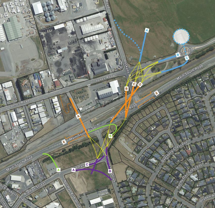
The initial proposed draft alignment

A ‘skewed’ flyover option plus a package of intersection improvements was
presented to the community for feedback in late 2021. This alignment emerged
from a multi-criteria assessment undertaken on a range of flyover options
pictured below.

Bridge alignment D emerged as the technically preferred option, which would then tie-in with Option B [purple] on the
northern side and Option B [purple] on the southern side to align with Rolleston Drive North, the main collector road.

SH1 Rolleston Transport Improvements | The path to a flyover – a summary of investigations                               7

The initial proposed draft alignment cont.

The flyover would extend over the existing SH1 and the
Main South Line and allow for the addition of a third rail
for rail operation improvements at Rolleston. (On the                     While people acknowledged the need to connect both
basis highway access would close completely at this                       sides of Rolleston, the public consultation process
location.)                                                                revealed some key community concerns about the
It was chosen because it offers a gentle gradient                         draft proposal for Rolleston which prompted further
(less than six per cent), had minimal property access                     investigation.
disruption, and delivered on the safety objective of zero                 These concerns included:
harm at the Hoskyns Road level crossing.
                                                                          • Reduced highway access – multiple points should
The option also supported the road hierarchy and                            remain open
network plan to keep traffic on main roads while offering
                                                                          • The potential for overloading Weedons Interchange
safer options for people choosing to walk or cycle.
                                                                          • Emergency service response times potentially
The other options did not perform as well because of                        affected
property impacts or gradient (alignment option A or
                                                                          • Increased traffic on local roads and past schools
B), or issues of geometry or constructability (alignment
options C and E).                                                         • Removing the Hoskyns Road level crossing required
                                                                            travel through multiple roundabouts
                                                                          • Closure of a section of Jones Road would affect
                                                                            access and be detrimental to businesses, services and
                                                                            facilities to the southwest industrial area.
                                                                          Some people commented that a bridge connecting to
                                                                          the east on Jones Road – and then having to backtrack to
                                                                          other industrial areas and businesses – was too limiting.
                                                                          People said they wanted access to all the industrial area
                                                                          and the continuity of Jones Road to remain.

SH1 Rolleston Transport Improvements | The path to a flyover – a summary of investigations                                       8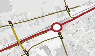
Bringing community feedback onboard

With this new community feedback and ongoing analysis confirming some
operational and constructability issues and given a fair amount of time had
passed since the options were first explored, Waka Kotahi reassessed the
options before developing the next set of draft plans.
Waka Kotahi values community input and because changes               • Fit with the local transport system
could be considered on this project that did not compromise          • Short and long-term effects on whole transport network –
safety (and were within scope and budget) the team was able            land use and road hierarchy
to undertake robust analysis of the options before developing
                                                                     • Community impact and liveability
the next set of plans.
                                                                     • Safety considerations
As part of the analysis the team assessed each option                • Environmental impacts
against the project investment objectives which were:
                                                                     • Highway access.
• Safety – working towards our Road to Zero target of
                                                                     The team, including a panel of independent and
  reducing people being killed and seriously injured on our
                                                                     subject matter experts, assessed more than 25 options
  roads by 40 per cent by 2030
                                                                     including:
• Connectivity – supporting a more connected community
  resulting in more economic self-sufficiency and liveable           • At grade options: signals, roundabouts, left in/left out
  Rolleston                                                          • Under/over north/south options
• Resilience and sustainability – providing a more resilient         • Over/under west/east options
  and sustainable transport network.                                 • Over/under skewed options.
Key considerations included:                                         The full list was initially assessed, and seven options were
• Reducing the risk of people from being killed and seriously        identified for Multi Criteria Analysis that then determined a
  injured on SH1 and rail crossings                                  shortlist of three feasible options.

        Safe system approach
        The safe system approach to transport planning recognises that people make mistakes and
        are vulnerable in a crash. It reduces the price paid for a mistake, so crashes don’t result in
        being killed or suffering life-changing serious injuries. Mistakes are inevitable – dying or
        being seriously injured from road crashes are not. To reach our national road safety strategy
        Road to Zero target of 40 per cent fewer deaths and serious injuries on our roads by 2030,
        Waka Kotahi has five internationally proven focus areas. These focus areas, including
        infrastructure and speed, vehicle safety, work-related road safety, road user choices and
        system management work together to create a safe transport system.

SH1 Rolleston Transport Improvements | The path to a flyover – a summary of investigations                                           9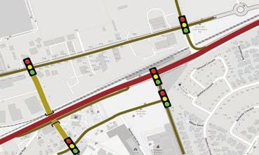
Bringing community feedback onboard cont.

       Short list of three feasible options                                      Short list options disregarded

        OPTION 4                                                                   OPTION 8

                                                                                  Straight flyover (plus NB on-ramp)

                                                                                   OPTION 10
       Skewed Flyover (refined consulted option)

        OPTION 7

                                                                                  RDN roundabout (signalised) + grade-separated
                                                                                  left out @ George Holmes Road

                                                                                   OPTION 13

       Straight flyover

        OPTION 24
                                                                                  Tennyson Drive overpass + RDN signal

                                                                                   OPTION 14

       Tennyson Drive to George Holmes underpass                                  Tennyson Drive overpass + RDN roundabout
       + SH1 (east-west) flyover + Hoskyns LO

SH1 Rolleston Transport Improvements | The path to a flyover – a summary of investigations                                        10
A revised preferred option for Rolleston
Weess Rd
Ro
H
RC
dons
A new third rail yard HU
A southbound service C
lane for people exiting
track and turnaround
R IST
area for trains CH
SH1 to Rolleston town s Rd
centre, highway
heading south Jone
amenities, and suburbs Weedons
Interchange
Iport
Izone
Hosky
Dr
Business
Weedons
Park
ns Rd
Rd
A straight flyover
Safety improvements - connecting Rolleston
left in and left out only township and industrial
for Rolleston Drive areas between
Rolles
t
South, Brookside Road, an S Rolleston Drive North
Kidm
We
ton Dr
and Tennyson Street and Jones Road
i Rd
edo
intersections Ten Lev
ns R
Nth
nys
d
d
hain R
on S
Two C
Rd
ide
t
Ma KEY
sefi
oks
Wa
Rolleston eld
Bro
Reserve Dr
lker
Rol Rail network
AM Dr leston
s Rd
R NH Sth Rol Linco New flyover (large trucks
BU r lest ln
on D on use Weedons Interchange)
lest Rd
Rol SH1 southbound service lane
Main commuter and freight
A new two-lane route
roundabout at Dunns d
es R
Spr
Crossing/Walkers Roads Local access
Low
ings
Rolleston Dunns Crossing/Walkers
ton
College
Roads roundabout
Roll
Dun
esto
Left turn access
ns C
(Left in/left out at Brookside
n Rd
Road, Tennyson Street and
ross
Rolleston Drive South. Left
ing
out only at Hoskyns Road.)
Rd
New traffic lights
Median barrier
Having listened to community feedback, undertaken further transport analysis
and comparing to a wide range of possible options again a range of factors,
a straight flyover alignment has emerged as the best option for the Rolleston
connection across SH1 and the rail corridor.
This alignment provides an extension of Rolleston Drive Hoskyns Road and southbound off-ramp from service
North through to a new T-intersection at Jones Road. lane to Kidman Street and Rolleston Drive North, enabling
people to ‘loop’ back across the flyover to the industrial
The main benefits include: area. This distributes highway access to more locations,
• A direct connection between Rolleston township via taking pressure off Weedons Interchange and reducing
Rolleston Drive North to the industrial area on Jones Road Tennyson Street traffic. These additions were included in
and the Hoskyns Road arterial route to West Melton and all options analysed
also SH73 • Engineering and construction advantages (less complex,
• A direct connection providing for a greater range of multi- lower embodied carbon and visual impact)
modal journeys between the town centre and industrial • Retaining full east-west Jones Road connectivity
areas – footpath on one side, shared path on the other • Maximising land for future development opportunities
• Removal of short-stacking risk at the rail level crossing – adjacent to Kidman Street and Jones Road – including
significantly reducing the safety risk to people – 40 near- expanded Park’n’Ride facilities
misses and collisions over the past ten years • Simpler bus service integration compared with the
• Some highway access is restored with a left out from skewed option.
SH1 Rolleston Transport Improvements | The path to a flyover – a summary of investigations 11A revised preferred option for Rolleston cont.
Concerns include:
• A rise similar to the Christchurch Northern A safer transport network is more efficient
Corridor Prestons Road overbridge – up to
As well as reducing the risk of people being killed or seriously
eight per cent gradient - but still acceptable
injured, road safety changes help to improve transport network
• Property acquisition is required efficiency. Crashes and other and other speed-related incidents
• Some outstanding issues to resolve in design create delays and stoppages, affecting freight timetables and the
such as bridge landing point intersection reliability of travel schedules. Businesses that rely on the roads
designs and understanding property and as an efficient part of their operation will benefit from transport
access impacts. safety improvements. An unsafe transport network cannot be an
efficient one.
Overall, it is the only option that scores best
against the investment objectives. It is the only Planning for the Rolleston Transport Improvements Project has
option that achieves a weighted positive score in factored in other transport projects in Selwyn District, which will
the Multi Criteria Analysis. It is also the option work together to create safer and more efficient travel for people
with the least negative effects. The flyover on the road. Examples include recent and planned local road
bridge will cater for all modes of transport upgrades (such as the Two Chain Road connection to Jones Road,
and help Rolleston become a more accessible, and Levi Road), the local walking and cycling network, park and
self-sufficient township. It aligns well with the ride opportunities (connecting to public transport) – which are all
current road network and recent upgrades and Selwyn District Council delivered projects.
links with walking and cycling paths and bus
SH1 through Selwyn will be made safer and more efficient through
stops to give people a range of travel options.
the delivery of infrastructure improvements – flexible barriers,
This will mean people have safer travel options
turn-around areas, changes to intersections and road markings
other than their car and the community is better
including widening the centre line – planned to extend 46.1km
placed to undertake targeted initiatives that
between Selwyn River and Ashburton.
mitigate and adapt to climate change.
SH1 Rolleston Transport Improvements | The path to a flyover – a summary of investigations 12Reasons behind second and third best options
The refined skewed option
The skewed flyover alignment was initially proposed because result was complex and not ideal. Compared with the straight
it offered a gentle gradient, had minimal property access flyover option it required more convoluted routes for all forms
disruption, and delivered on a key safety objective by closing of traffic – including people using the shared path – between
highway access and completely removing the risk for people the Rolleston Town Centre and industrial areas. Furthermore,
at the Hoskyns Road level crossing. the bridge structure is more complex to construct and will
result in higher embodied carbon emissions due to 65m
Following public consultation and further technical analysis,
spans needing large steel girders rather than standard
the design was refined to improve access to the highway and
concrete beans.
east-west connectivity along Jones Road. However, the end
Straight over or under the highway from Rolleston town centre (Tennyson Street)
The Tennyson-George Holmes connection offers some The team also investigated how people would use the various
advantages. It separates out local north-south movements routes in each of the options.
from State Highway access and provides good connection A tunnel from Rolleston Drive North straight through to
between the town centre and industrial zone. The main Jones Road was ruled out because of the negative effects.
problem with this design is it results in increased traffic along These include: the amount of private property required
Tennyson and Kidman Streets areas and past the primary including to provide for the structured and drainage as
school. Significantly increasing vehicle traffic into these areas well as CPTED considerations. (CPTED Crime Prevention
– potentially 15,000 vehicles a day – would be detrimental Through Environmental Design is a well-researched multi-
to Selwyn District Council’s vision for a community and disciplinary approach to deterring criminal behaviour through
retail focused Town Centre which is a pedestrian friendly, environmental design). The tunnel would have up to 20,000
community hub. Also, this option would still require traffic vehicles per day passing through and sometimes idling as
signals at the Rolleston Drive North/SH1 intersection. This they queue on the uphill incline during peak times. Even with
would not support a safe transport network or project safety ventilation, this would be unpleasant for people using the
investment objectives. As well, highway freight productivity shared path to walk, cycle and scoot etc and could be subject
would be negatively impacted if this intersection remained. to flooding during severe weather events.
This image shows a jackknifed truck at Hoskins Road level crossing. Kiwirail have reported 40 near misses at this dangerous intersection.
SH1 Rolleston Transport Improvements | The path to a flyover – a summary of investigations 13Reasons behind second and third best options
Proposed rail improvements
A safe reliable and resilient road and rail network is needed for longer vehicles to queue safely at the level crossing
to support growth. More rail freight helps to reduce trucks on barrier. This causes vehicle queues, delays, and safety
the road, which is safer for everyone. Using rail reduces New issues – approximately 40 near-misses – which has resulted
Zealand’s carbon emissions by 488,000 tonnes a year – the in KiwiRail restricting freight to an inefficient 40km/h at
equivalent of taking 87,000 cars off the road – saving millions Rolleston.
of dollars. Rail freight has 66 per cent fewer carbon emissions
than heavy road freight. Other issues include:
Rolleston was historically important as the site of the junction • No direct connection from the south on the Main South
of the Midland Line and Main South Line. The Midland Line Line and Midland line
passes to the southwest of the Rolleston Industrial Zone and • No direct connection to the Lyttelton Port siding from the
heads west to the West Coast and Greymouth. The Main south
South Line is part of the South Island’s Main Trunk rail line • Inefficient rail operation resulting in additional level
(running north and south), connecting key economic hubs crossing closures.
in the South Island for freight import and export. The Main Waka Kotahi and KiwiRail explored four feasible options for
South Line connects to the Midland Line approximately improving rail in Rolleston. The recommended option gives
700m south of the Weedons Ross Road level crossing and the greatest flexibility for rail connectivity and operational
is critical for freight access to the inland ports supporting improvements by:
the South Island. Freight connections to The West Coast are
critical for these communities and the economy. • Focusing the run around yard east of Midland Port
• Removing the need for a third track over Hoskyns Road
There are between 20-30 rail movements a day on the
Midland Line to the West Coast and 40 rail movements a day • Improving safety with a two-track level crossing
north of Rolleston (including trains to Lyttleton Port Company • Left out access only from Hoskyns Road will remove short
every day). There are eight movements south of Rolleston on stacking across the rail line
the Main South Line of Rolleston. The daily TranzAlpine train • Preserving land at Hoskyns Road and Jones Road for future
can stop at Rolleston if people pre-book. development opportunities including expanded Park’n’Ride
An increase in the number of trains is resulting in more traffic facilities.
hold-ups at the Hoskyns Road level crossing. Because of The Walkers Road rail level crossing will be upgraded as
the proximity of the rail line to the highway there are short- part of the proposed new roundabout project at SH1/Dunns
stacking issues which means there is not sufficient space Crossing/Walkers Roads intersection.
SH1 Rolleston Transport Improvements | The path to a flyover – a summary of investigations 14Reasons behind second and third best options cont.
ns Rd
Hosky
Jones R
d
Proposed improvements indicated by green lines
SH1 Rolleston Transport Improvements | The path to a flyover – a summary of investigations 15Public consultation 2022
Once the straight flyover option was identified as the front-runner through
the multi-criteria analysis process the team engaged with the most affected
adjacent property owners.
The proposal requires some privately owned land and Dunns Crossing intersection. Feedback from Ia Ara Aotearoa
access to these properties will be affected. Waka Kotahi is Transporting New Zealand indicated support for the
continuing to explore ways to minimise impacts for these recommended straight flyover alignment.
property owners. Most of the land required is owned by
Thank you to everyone who provided feedback on the draft
Waka Kotahi, Selwyn District Council and KiwiRail.
design.
Waka Kotahi also tested the proposal with
key stakeholders to sound out whether The project will make it easier and safer to get
they thought the recommended alignment around Rolleston and provides people with more
would meet their needs and provide a transport choices. It aims to improve connectivity
workable solution for the community and access between the residential and industrial
of Rolleston. sides of Rolleston, improve safety at high-risk
intersections– as well as provide a more resilient
Overall feedback was supportive of the
recommend option. While the option did not and sustainable road and rail network.
suit every group’s requirements exactly, people Visit www.nzta.govt.nz/sh1-rolleston to view a fly-
appreciated the challenges of meeting key project objectives through video and public consultation brochure outlining
and community desires and needs. the recommended straight flyover alignment as well as
Feedback from emergency services on the emerging more information including answers to frequently asked
preferred alignment was supportive. Their preference was questions. You can also subscribe to updates to receive
to prioritise the new roundabout at the SH1/Walkers Road/ the latest project information.
SH1 Rolleston Transport Improvements | The path to a flyover – a summary of investigations 16You can also read