SITUATION UPDATE No. 3 - AHA Centre
←
→
Page content transcription
If your browser does not render page correctly, please read the page content below

SITUATION UPDATE No. 3
                              M 6.4 Lombok Earthquake (29 Jul 2018) &                                                              No.   3
                         M 7.0 Lombok Earthquake (5 Aug 2018), INDONESIA
                                 adinet.ahacentre.org/reports/view/1249 | https://reliefweb.int/disaster/eq-2018-000122-idn

                                     Thursday, 9 August 2018, 20:00 hrs (UTC+7)

 This situation update is provided by AHA Centre for the use of ASEAN Member States and relevant parties among ASEAN Member States. The
 information presented is collected from various sources including but not limited to ASEAN Member States, UN, IFRC, INGOs, & News Agencies.

1. HIGHLIGHTS

a. A Magnitude 7.0 earthquake occurred on 5 August 2018 18:46 hrs (UTC +7), with
   epicenter at a depth of 10 km and located at 8o22’12.0” S & 116o28’48.00” E (inland),
   in the area of West Nusa Tenggara Province, Indonesia (BMKG). The earthquake
   was felt in Lombok, Bali and Sumbawa Island. A tsunami warning was triggered,
   which was cancelled after two hours since only minor tsunami was observed (BMKG).
b. A strong aftershock, measured M 6.2, with epicenter located 8.36 S and 116.22 E, 12
   km below ground surface. The intensity felt in North Lombok Regency (most affected
   area) was around III-VI MMI (BMKG).
c. According to the latest government figure (9 August 2018), there are 259 recorded
   fatalities, 1,033 injuries, 270,168 internally-displaced people (IDPs), 64,534 damaged
   houses, and 429 damaged public facilities (BNPB).
d. The Government of Indonesia through the National Disaster Management
   Authority (BNPB) has strongly stated that international assistance is not
   required at this point of time. BNPB has encouraged all line ministries to support
   monitoring of international stakeholders’ activities. BNPB has also encouraged all
   national/local NGOs based in Indonesia not to invite their international partners.
   Those who already arrived will be put on hold and cannot implement any of their
   activities until further notice. Current emergency response period is until 11 August
   2018.
e. Initial sectoral damage and impact assessment activities are being undertaken by
   various national government agencies and organizations. Several crowd-source
   efforts to support assessment of damages and humanitarian needs are also available,
   which will be verified by BNPB and partners on-site.
f. The AHA Centre is in close coordination with the BNPB of Indonesia and providing
   support on information management and dissemination of information to regional and
   international stakeholders both at headquarter and field levels. This includes inclusion
   of official National Disaster Management Authority (BNPB) statement into the AHA
   Centre Situation Update.
g. The AHA Centre In-Country Liaison Team (ICLT) arrived on 6 August 2018 to
   establish communication on-site with BNPB and provide coordination support. All
   ASEAN Emergency Response and Assessment Team (ERAT) members arrived on 8
   and 9 August 2018. While BNPB has welcomed ASEAN-ERAT, their primary
   deployment purpose is to learn from Indonesia on its experience in managing the
   disaster and get exposure on the ongoing emergency response operation.
h. The AHA Centre flash updates on this disaster can be found here:
   https://ahacentre.org/flash-updates/ while series of situation updates can be found
   here: https://ahacentre.org/situation-updates/

                                                                                                                        SITUATION UPDATE
                                                                     1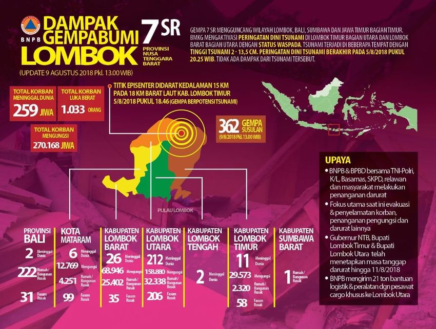
2. SUMMARY OF EVENTS, FORECAST, AND ANTICIPATED RISK

a. Indonesian Meteorology, Climatology
   and Geophysics Agency (BMKG)
   provides an infographic for general
   public (as can be seen below, in
   Bahasa        Indonesia)       on     the
   characteristics of earthquakes in
   Lombok. The phenomena observed is
   a set of series of foreshocks, main
   shock, and aftershocks occurred along
   one back arc system, with similar
   mechanism and relatively near
   epicentre location. BMKG estimated
   that according to aftershocks recorded
   until 8 August 2019 processed with
   Mogi 1 equation, the trend of tremors
   in Lombok will decrease in 3-4 weeks’ time. Accordingly, responders on the ground
   must maintain their preparedness to strong aftershock and BMKG’s recommendation
   is provided in Section 5 of this Situation Update.
b. As can be seen on the right
   figure, until 9 Aug 2018 (2100
   hrs UTC+8), BMKG recorded
   392 aftershocks following the
   M 7.0 earthquake on 5 August
   2018, 1846 hrs (UTC+7), with
   19 of them were felt due to
   moderate shaking (>M 4.5).
   These       aftershocks       may
   become additional risk to
   crippled buildings, responders,
   affected population houses and infrastructures. The latest one was M 6.2 earthquake,
   with epicenter located 8.36 S and 116.22 E, 12 km below ground surface. The
   intensity felt in North Lombok Regency (most affected area) was around III-IV MMI
   (BMKG).
c. It is currently hot and dry in
   Lombok, Bali and Sumba islands.
   A drought occurrence has been
   identified    in    Lombok      and
   Sumbawa islands of West Nusa
   Tenggara (NTB) Province since
   rainfall record is only around 0-20
   mm. The total needs of clean
   water for affected population
   should      be      projected     by
   considering the rainfall pattern.
   Figure on the right showcases the rainfall accumulation across the affected areas
   (AHA Centre DMRS).

                                                                      SITUATION UPDATE
                                         2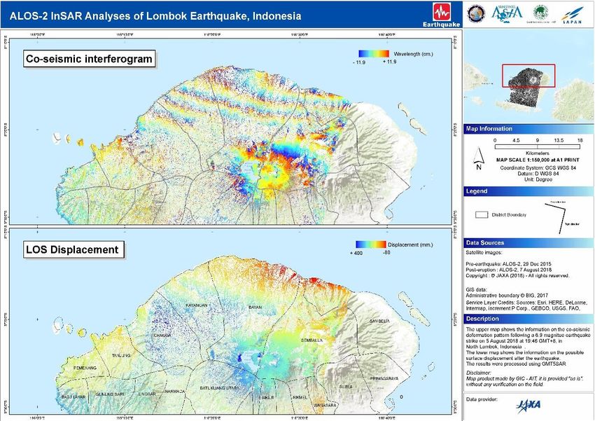
d. Upon activation of Emergency Observation through Sentinel Asia Platform through
   AHA Centre, InSAR analyses of Lombok Earthquake is now available, below.

3. ASSESSMENT OF DAMAGE, IMPACT, AND HUMANITARIAN NEEDS

a. As of 9 August 2018, BNPB’s casualties and damage information can be found in the
   table and infographic below. There are 259 fatalities confirmed, 1,033 injuries,
   270,168 people injured. In addition, 64,534 damaged houses and 429 damaged
   facilities are confirmed. Focus of operations remains in West, North and East Lombok.

                                                                       SITUATION UPDATE
                                         3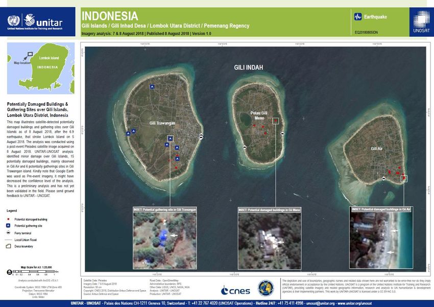
b. Following the activation of Sentinel Asia platform and Disaster Charter, at least three
   remote damage assessment activities through aerial survey and satellite observation
   have been completed: 1) by Indonesian agencies (BNPB, BIG, BPPT, and PVMBG)
   following the M 6.4 earthquake (upper-left figure); and 2) by UNITAR-UNOSAT
   following the M 7.0 earthquake (upper-right); and 3) Regional Service of Image
   Processing and Remote Sensing (SERTIT) (bottom). Higher resolution images are
   available in the attachment. Until 9 August 2018, UNITAR-UNOSAT managed to add
   additional one imagery from the Gili Trawangan, Gili Meno and Gili Air, where tourists
   are concentrated. In addition, SERTIT managed to analyze additional imagery for
   Salangan Village, Kayangan District, North Lombok Regency. Both additional images
   can be found below (upper side, UNITAR-UNOSAT; lower side, SERTIT), while the
   previous ones can be found in AHA Centre Situation Update No. 2.

   Accordingly, 9 out of total 52 villages affected have been assessed remotely
   with around 2,788 buildings potentially damaged. Accordingly, scaling up
   assessment areas and ground verification efforts are required. Those villages (except
   for Gili Indah) were also identified by BNPB as isolated areas and requiring immediate
   assistance.

    Remote Assessment
                               Observed areas                    Results
    activities
                               Regency: East Lombok              129 damaged buildings, out
                               District: Sambalia                of total 287 (44.9%)
                               Village: Mentareng, Obel-obel
                               Regency: East Lombok              34 damaged buildings, out
    Aerial survey by BNPB,
                               District: Sambalia                of total 165 (20.06%)
    BIG, BPPT, and PVMBG
                               Village: Pemadekan, Obel-obel
                               Regency: East Lombok              18 damaged buildings, out
                               District: Sambalia                of total 116 buildings
                               Village: Obel-obel, Obel-obel     (15.5%)
                               Regency: North Lombok             UNITAR-UNOSAT analysis
                               District: Kagayan                 identified 1,274 potentially
                               Villages: Gumantar and            damaged structures in the
    Damaged assessment
                               Dangiang                          area.
    based on Satellite-
                               Regency: North Lombok             UNITAR-UNOSAT analysis
    observation UNITAR-
                               District: Pemenang                identified 15 potentially
    UNOSAT
                               Village: Gili Indah (three Gili   damaged buildings and 6
                               islands)                          potentially gathering sites in
                                                                 Gili Indah village
                               Regency: North Lombok             1,033 damaged buildings
                               District: Salangan                detected, with additional
                               Villages: Bagek Gembar,           268 buildings potentially
    Government of France,      Lokok Sutrang                     damaged
    Regional Service of        Regency: North Lombok             Approximately 70 ‘very
    Image Processing and       District: Kayangan                affected’ buildings and 230
    Remote Sensing             Villages: Salangan                ‘affected’ buildings. The
    (SERTIT)                                                     imagery also managed to
                                                                 identify ‘spontaneous
                                                                 gathering area’ that may be
                                                                 indicates an evacuation site

                                                                            SITUATION UPDATE
                                           4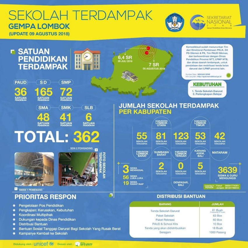
c. In education sector, according to the data received from the Ministry of Education and
   Culture (MoEC) on 9 August 2018, three fatalities of students are confirmed; along
   with 56 students injured, and 3,639 students and teachers displaced. A total of 263
   schools were damaged; i.e. 55 in West Lombok Regency, 81 in North Lombok
   Regency, 123 in Central Lombok, 53 in East Lombok Regency, 42 in Mataram City,
   2 in West Sumbawa, and 5 in Karangasem, Bali. MoEC infographic available below.

                                                                       SITUATION UPDATE
                                          5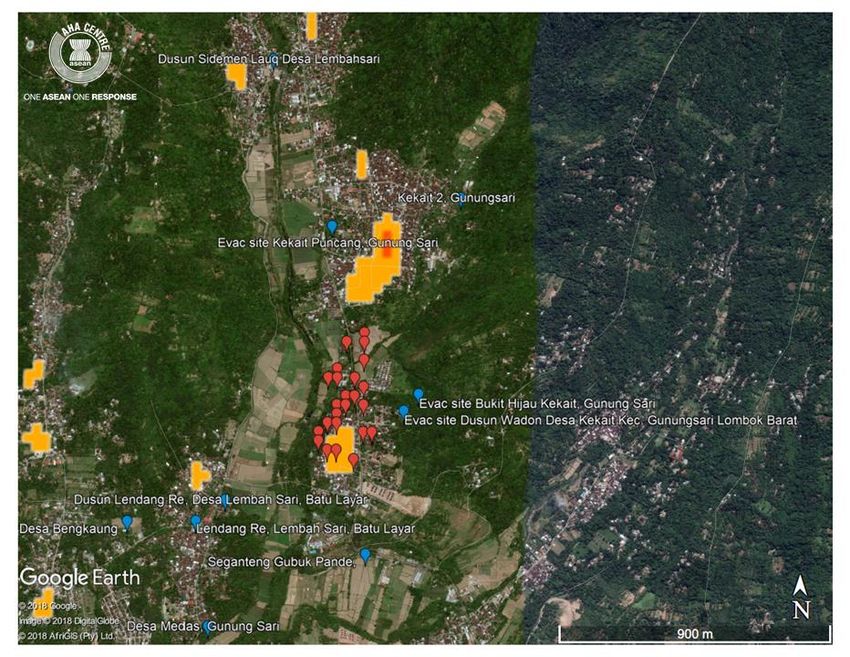
4. ACTIONS TAKEN AND RESOURCES MOBILISED

Response by Government of Indonesia
a. Incident Command Post(s) have been established by the local disaster management
   organisations (BPBDs) on scene. BNPB has established National Assisting Post
   (Pospenas) in Tanjung District, North Lombok Regency, (8o22’12.0” South &
   116o28’48.00” East). Indonesian Armed Forces is opening a post in Halim
   Perdanakusuma Airport for receiving relief items and resources, and sending them to
   Lombok.
b. BNPB, related BPBDs, Indonesian Armed Forces, Indonesian Police, and other line
   ministries continue search and rescue activities, and basic emergency support. In total
   BNPB has sent 21 tons of relief items to the affected areas.
c. The Ministry of Education and Culture has distributed 61 temporary school tents (22
   constructed), 63 boxes of school packages, 60 recreational packages, 10 boxes school
   kits, and 1,000 uniforms. Education Agency of West Nusa Tenggara Province (NTB)
   released circular letter of the resumption of school activities starting from 9 August
   2018. The agency provides guideline on the activities, including trauma healing.
d. The Indonesian postal office announces that it is offering free shippping service for
   relief items for the victims of Lombok earthquake. Users can send send up to 20kg per
   shipment and can send multiple shipment. Users can send the relief items to the
   address KP Mataram or to "Posko".
e. Ministry of Communication and Information has provided additional VSAT connectivity
   in West Lombok Regency Command Post (source: AHA Centre ICLT).

                                                                        SITUATION UPDATE
                                          6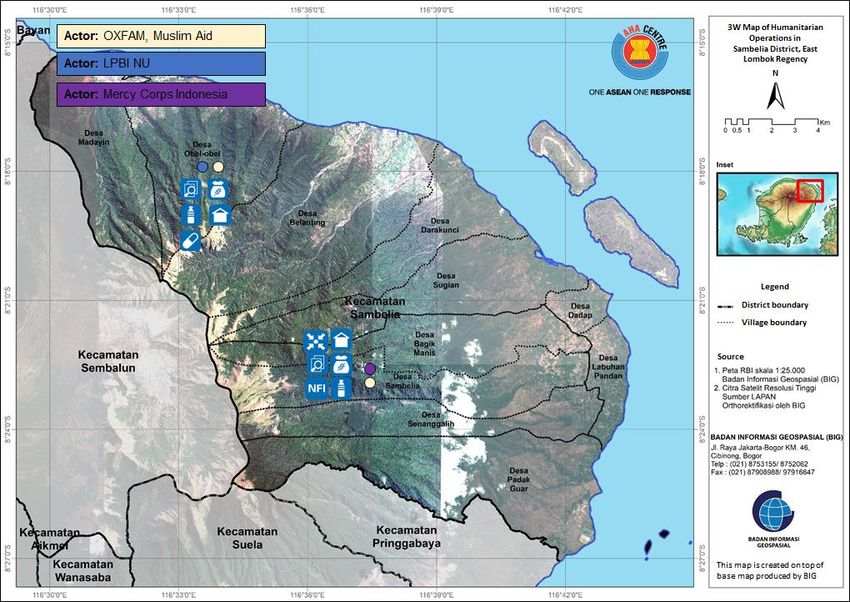
Response by the AHA Centre
a. The AHA Centre is in close coordination with the BNPB of Indonesia and providing
support on information management and dissemination of information to regional and
international stakeholders both at headquarter and field levels. This includes inclusion
of official BNPB products and information into the AHA Centre Situation Update. The
AHA Centre ICLT was dispatched by the AHA Centre to Lombok Island on 6 August
2018 for supporting on-site coordination.
b. All ERAT members have arrived on-site 9 August 2018. While BNPB has welcomed
ASEAN-ERAT, their primary deployment purpose is to learn from Indonesia on its
experience in managing the disaster and get exposure on the ongoing emergency
response operation.
ASEAN-Emergency Response and Assessment Team (ERAT) is on the ground and
observing the operations coordinated by BNPB
Response by National Humanitarian Partners
a. Based on the data received on 9 August 2018, there have been several additions of
assistance from the following humanitarian partners:
Aksara has provided WASH support at Gangga District
SITUATION UPDATE
7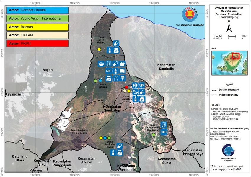
Arbeiter Samariter Bund (ASB) Indonesia has conducted needs assessment for
person with disabilities at Gunung Sari District
Islamic Relief has dispatched food, non-food items, drinking water at Tanjung
District, North Lombok Regency
Nahdlatul Ulama Disaster Management and Climate Change Adaptation
Organisation (LPBI NU) has conducted assessment, dispatched medical
assistance, food, shelter and drinking water at Sambelia district, Sembalun district,
Pemenang district, Gangga district, Lingsar district and Gunungsari district
Mercy Corps Indonesia has conducted assessment at Suela district, Sembalun
district and Sambalia district.
b. Accordingly, until 9 August 2018 there are 17 Indonesian-based national/local NGOs:
Indonesian Red Cross (PMI), Plan Indonesia, Yakum Emergency Unit (YEU), Dompet
Dhuafa, ADRA, Muslim Aid, Oxfam, Baznas, Yayasan Sayangi Tunas Cilik (YTSC /
Save the Children), Wahana Visi Indonesia (WVI), PKPU Human Initiative,
Muhammadiyah Disaster Management Centre (MDMC), Aksara, Islamic Relief
Indonesia, ASB, LPBI-NU, and Mercy Crops Indonesia. As shared during national
cluster on protection coordination meeting their activities ranging from assessment,
distribution of food, non-food-items, WASH assistance, etc. Overall, the assistance
able to reach 25 villages (out of 52) in North Lombok and East Lombok Regency.
c. The AHA Centre is providing initial 3W Map of the national NGOs movement that can
be found in the attachment part.
5. RECOMMENDATIONS AND PLANNED ACTIONS
Recommendations to be considered by humanitarian partners
a. Due to seismic hazard characteristics in the affected areas, as described in Section 2,
humanitarian partners and responders should exercise cautions during their
operations, prepare and implement a security plan, and be alerted to potential
collateral disasters.
b. BMKG advised the general public on the possibility of additional collapsed building due
to its condition after series of strong tremors. It may best not to stay in crippled houses
and buildings for time being.
c. Safety of humanitarian workers has to be ensured due to identified security risk of
looting on the ground.
d. Disaster responders and humanitarian workers have to ensure safe evacuation sites,
preferably outdoor in a solid ground, in anticipation of aftershocks or landslides.
e. With the current and near-future availability of satellite imageries and aerial survey, it
can be used for on the ground validation and assessment of building damages and
need of rehabilitation and reconstruction. Please also refer to planned actions by AHA
Centre and ASEAN-ERAT, for reference by other humanitarian partners.
f. Local/national humanitarian organisations may wish to maintain information sharing
and assistance tracking available in this page.
g. Recommendation on health emergency response, based on the latest and projected
development in reference to past disaster experience.
Promote the reinforcement of trauma healing support (psychological/ mental health
support) especially in evacuation/ relocation sites
Given the increasing number of displaced or affected people that may be referred to
shelters or evacuation/ relocation sites, provision of clean drinking water, food/
nutrition and water and sanitation facilities in evacuation/ relocation sites should be
sustained. Close monitoring of public health and health indicators in these sites is
necessary to prevent the occurrence of disease outbreaks.
On the increasing casualties, the inclusion of the management of the deceased in
the response plan is essential. Cultural practices and needs of the family should also
be given priority. Further:
SITUATION UPDATE
8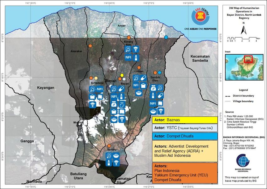
o Reinforcement of coordination
among diverse teams of personnel
(e.g. rescue personnel, forensic
medicine experts, prosecutors,
police, administrative personnel,
psychologists, support teams) to
manage the deceased will be
necessary; reference: here.
o Supplementation of the proper
management may include
international references to take
into consideration the soil
Example of temporary burial of dead
condition, water table level and
bodies in Thailand following the tsunami
available space. Among which,
disaster on 26 December 2004
graveyards should be located at
least 50 meters from the ground
water sources used for drinking water, at least 500 meters from the nearest
habitable building or structure and in an area of at least 1,500 meters per 10,000
population. Reference can be found here and here.
As reported on the potential risk of exposure to asbestos, damage to material
containing asbestos can result in the release of small asbestos fibres that become
airborne and are readily inhaled. Although asbestos is not acutely hazardous to
health, the asbestos fibers can remain in the lungs for a long period of time causing
diseases such as asbestosis and lung cancer. Reference can be found here.
Preventive measures can be taken are as follow:
o As a minimum measure, provide workers with gloves, goggles, disposable clothing
or replacement clothing and disposable dust masks. Contaminated clothing and
protective equipment should be disposed of in the same way as other asbestos-
containing materials. Provide washing facilities for workers and ensure that they
are aware of the need to wash before eating, drinking or smoking and before
returning home to minimise the risk of spreading asbestos fibres.
o In the communities, do restrict access to sites where there are piles of building
debris including demolition sites and waste sites. Clean surfaces contaminated
with asbestos-containing materials using wet methods. Do not dust or sweep
because this will propel fibres and dust into the air. Keep piles of asbestos-
containing materials covered such as tarpaulins or sheets of plastic until they can
be safely stored or disposed of. Wet thoroughly before moving the materials.
Reference can be found here.
Planned actions by AHA Centre and ASEAN-ERAT
a. The AHA Centre is seconding staff to BNPB’s Data and Information Centre (Pusdatin)
for supporting dissemination of official information to international stakeholders.
b. According to latest coordination with BNPB’s post in West Lombok Regency, ASEAN-
ERAT will observe assessment and verification of damages and evacuation sites in
Batu Layar and Gunung Sari districts. The suggested process of verification can be
combine the available crowd-source report, on-site verification to areas with potential
damages as analysed through satellite observation, and combined with ground
verification by responders. This can be done through the following steps and
illustration below, which will be conducted by ASEAN-ERAT:
1. Verify location and situation of evacuation sites in both districts (blue points)
2. Verify reported damages (red points) that already triangulated with satellite
observations (orange / red areas)
SITUATION UPDATE
9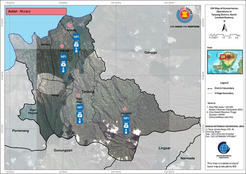
3. Visit and onsite verification of areas identified with potential damages (according
       to satellite imagery analysis); and contribute ground photos / observation

    ASEAN-ERAT will conduct verification to sites identified through satellite-imageries
    and analysis made available by Sentinel Asia-Data Analysis Nodes.

c. The AHA Centre will provide further updates as situation progresses and more
   information is available.

Prepared by:
AHA Centre - Emergency Operations Centre (EOC) in collaboration with BNPB’s Data and Information Centre (Pusdatin)

Contact:
1) Qingyuan Pang, Asst. Director, Disaster Monitoring & Analysis, qing.pang@ahacentre.org
2) Mizan B. F. Bisri, Disaster Monitoring & Analysis Officer, mizan.bisri@ahacentre.org

ABOUT THE AHA CENTRE
The AHA Centre - ASEAN Coordinating Centre for Humanitarian Assistance on disaster management - is an inter-
governmental organisation established by 10 ASEAN Member States – Brunei Darussalam, Cambodia, Indonesia, Lao
PDR, Malaysia, Myanmar, Philippines, Singapore, Thailand and Viet Nam - to facilitate the cooperation and coordination
among ASEAN Member States and with the United Nations and international organisations for disaster management and
emergency response in the region.

The ASEAN Coordinating Centre for Humanitarian Assistance on disaster management
(AHA Centre), Graha BNPB 13th Floor, JL Raya Pramuka Kav 38, East Jakarta, 13210, Indonesia
Phone: +62-21-210-12278 │ www.ahacentre.org │ email: info@ahacentre.org

                                                                                               SITUATION UPDATE
                                                       10
Attachment
a. National NGOs humanitarian operations / 3W Map in Bayan District, North Lombok
Regency, as of 9 August 2018 (data provided by national cluster on protection)
b. National NGOs humanitarian operations / 3W Map in Gangga District, North Lombok
Regency, as of 9 August 2018 (data provided by national cluster on protection)
SITUATION UPDATE
11c. National NGOs humanitarian operations / 3W Map in Tanjung District, North Lombok
Regency, as of 9 August 2018 (data provided by national cluster on protection)
d. National NGOs humanitarian operations / 3W Map in Sembalun District, East Lombok
Regency, as of 9 August 2018 (data provided by national cluster on protection)
SITUATION UPDATE
12e. National NGOs humanitarian operations / 3W Map in Sambelia District, East
Lombok Regency, as of 9 August 2018 (data provided by national cluster on
protection)
SITUATION UPDATE
13You can also read


