Spatial survey of tephra deposits in the middle Lahn valley (Hesse, Germany)
←
→
Page content transcription
If your browser does not render page correctly, please read the page content below

Express report
E&G Quaternary Sci. J., 70, 165–169, 2021
https://doi.org/10.5194/egqsj-70-165-2021
© Author(s) 2021. This work is distributed under
the Creative Commons Attribution 4.0 License.

Spatial survey of tephra deposits in the middle Lahn valley
(Hesse, Germany)
Collin J. Weber, Volker M. H. Dickhardt, and Stefan Harnischmacher
Department of Geography, Philipps-University Marburg, Marburg, 35032, Germany

Correspondence:           Collin J. Weber (collin.weber@geo.uni-marburg.de)

Relevant dates:           Received: 26 March 2021 – Revised: 11 May 2021 – Accepted: 1 June 2021 –
                          Published: 1 July 2021

How to cite:              Weber, C. J., Dickhardt, V. M. H., and Harnischmacher, S.: Spatial survey of tephra de-
                          posits in the middle Lahn valley (Hesse, Germany), E&G Quaternary Sci. J., 70, 165–169,
                          https://doi.org/10.5194/egqsj-70-165-2021, 2021.

1   Introduction                                                   2003; Lomax et al., 2018). Further well-summarized infor-
                                                                   mation about the situation within the Niederweimar gravel
Tephra deposits and especially Laacher See tephra (LST)            quarry can be found in Lomax et al. (2018) or on the website
deposits resulting from the Laacher See eruption (12.9 ka)         of the archaeological survey of Hesse (https://lfd.hessen.de/,
are an important stratigraphic marker for the Allerød period       last access: 21 March 2021).
in central Europe (van den Bogaard and Schmincke, 1995).              The evidence of LST in the Lahn valley, as in other valley
Within the central German low mountain range (Rhenish              sediments, is often limited to gravel pits (other larger excava-
Massif and eastern areas) the LST was found within soils           tions). These pits and their profiles offer very good insights
(initial deposits, sheltered slope positions) and valleys (relo-   (e.g. detailed lithostratigraphic description of profiles), but
cated deposits) (Bos and Urz, 2003; Hahn and Opp, 2005).           they are always limited to a comparatively small spatial sec-
The Niederweimar gravel quarry, located on the lower ter-          tion of the entire floodplain (gravel pit area). Therefore, the
race in the middle reach of the Lahn River valley south of         objective of the presented study is to provide a spatial sur-
Marburg (Hesse, Germany), is known for its high-resolution         vey of LST deposits in the middle Lahn valley, covering the
stratigraphy of Quaternary gravel deposits and late glacial,       entire floodplain cross section. The following two questions
as well as Holocene, floodplain fines (Lomax et al., 2018).        form the focus of the spatial survey. (1) How is the lateral
This particular stratigraphy is mainly achieved by the up to       and vertical extension of the LST deposits within the Lahn
2 m thick LST deposits, which consist of pure LST beds and         valley floodplain? (2) Does the spatial distribution provide
a multitude of fine LST bands (partly interbedded with black       overarching information about the deposition dynamics of
sands or interrupted by clay bands). The origin of the LST         the LST? For this purpose, a transect-based survey with qual-
in the floodplain is attributed to an extensive deposition (ae-    itative analysis of LST grains based on density separation and
olian, directly in the floodplain), as well as later fragmenta-    visual identification (stereomicroscope) was applied.
tion of the tephra deposits by surface erosion and renewed
deposition of LST from the catchment area through chang-
ing river systems (Bos and Urz, 2003; Lomax et al., 2018).         2   Methods
The surroundings of the gravel quarry are also rich in archae-
ological finds reaching more or less continuously from the         Survey and sampling of tephra samples was conducted at
Mesolithic (11.7 to 7.5 ka) to the Middle Ages (Bos and Urz,       three floodplain transects (including active floodplain zone
                                                                   and lower terrace) in the south of Niederweimar gravel

Published by Copernicus Publications on behalf of the Deutsche Quartärvereinigung (DEUQUA) e.V.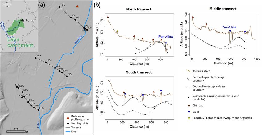
166                                                                       C. J. Weber et al.: Tephra deposits in the Lahn valley

quarry where the floodplain shows one of its greatest trans-         3   Results and discussion
verse expansions (Fig. 1). Transects cover a maximum width
of 973.9 m and are at 170.9 m a.s.l. (above sea level) with a        In total 56 tephra containing stratigraphically distinguishable
height difference of ±1.4 m. Sampling was carried out with           layers were identified and sampled. Qualitative tephra anal-
the help of a hand auger (Pürckhauer, Ø 2 cm, 2 m depth) and         yses within the laboratory show a positive rate of 69.6 % in
pile core probing (Ø 6–8 cm, 3 m depth). Soil properties and         which case tephra could be detected under the microscope
stratigraphy were documented in the field according to the           for the 56 samples. In 30.4 % of the layers, no tephra grains
national standard soil classification scheme (KA5, Ad-hoc            or larger fragments could be found even if the Greasing ef-
AG Boden, 2005). Tephra-containing layers were identified            fect occurred in the field. The applied method is therefore
visually (visible tephra grains) or by smeary consistence (ow-       suitable for qualitative detection, is fast and inexpensive, and
ing to higher contents of allophane) (Jahn et al., 2006), pro-       can be extended by other methods such as mineral analy-
portion documented (percentage of tephra grains estimated            sis and dating. Tephra grains occur usually entire with grey-
by area according to KA5), and extracted for further analy-          brown to greenish colours, clear holes and glassy surface
sis.                                                                 structure (Fig. 2). The length to width ratio of the grains from
    Samples for method validation and as comparison mate-            a random sample of 30 grains comprises an average length
rial (reference samples) were taken from a recently exca-            of 782.7 (±288.4) µm and width of 557.12 (±179.5) µm.
vated profile (32U 480710 5621590) in the Niederweimar               Grain surface and average and maximum length (1565.9 µm)
gravel quarry, which was excavated during archaeological             correspond clearly to the reference samples (same colour,
work. The profile consists of Holocene floodplain loams (silt        holes and glassy structure) with an average length of 724.3
to sandy loam) above four LST layers (sandy loam, partwise           (±245.6) µm.
alternating with black sands and ripple) and flood loam (late           Tephra layers come up at average depths of 68.6 cm below
Pleistocene) at the base (Fig. 2). Three samples were taken          surface and end at average depths of 166.5 cm (±46.3 cm).
from the upper (LST bands mixed with sandy loam), mid-               Tephra layers have thicknesses from 6.0 up to 132.0 cm with
dle (thick LST bands, between black sands) and lower (LST            an average thickness of 52.0 cm (Figs. 1b and 2). Grain size
bands interrupted by black sands with ripple shapes) parts of        analyses of tephra-containing layers has a mean distribution
the LST layer (Fig. 2).                                              of 30.2 % clay, 46.8 % silt and 23.1 % sand. However, the
    Reference samples and samples from the transects were            share of sand is ranging between 2.7 % and 57.9 %, resulting
dried at 100 ◦ C (drying chamber) under weight loss con-             in the samples comprising the grain size classes clay, silty
trol, subsequently carefully ground, and sieved to < 2 mm            clay, silty clay loam to silt loam (outliers within loam and
(stainless steel sieve, Retsch, Haan, Germany). Subsample            sandy loam), and they are thus very heterogeneous.
material (20g per sample) was then mixed with 150 mL                    Stratigraphic classification of tephra layers corresponds
saturated NaCl solution (density adjusted, ρ = 1.2 g cm−3 )          to the findings of our reference profile and other profiles
within glass beakers, stirred (1 min, magnetic stirrer) and al-      within the Niederweimar quarry (e.g. Lomax et al., 2018):
lowed to sediment for 20 min. This allows the tephra grains          The tephra layers are covered by Holocene floodplain sedi-
to be separated from other mineral components (sand to               ments (floodplain loams, silty loams) and rarely with single
clay grains), despite the heavy minerals contained (Lomax et         clay layers or isolated gravel deposits. The lowermost tephra
al., 2018), because the grains float in the dry state due to their   layers, partly with the same pattern of banding (LST bands
many cavities (volcanic origin). The floating tephra grains          and black sands) (Fig. 2), however, are only poorly visible
were then sieved to > 50 µm (Atechnik, Leinburg, Germany)            within the drill sample in contrast to quarry profiles. Below
to separate clay and/or silt particles and filtered by vacuum        the tephra, a thin band (approx. 5 cm) of sand with gravel
filtration (cellulose filter, LLG-Labware, Meckenheim, Ger-          occurs, followed by a thick layer of clay (dark and rich in or-
many) to rinse out remaining salts. Dried filters were visu-         ganic matter), before the gravel deposits of the lower terrace
ally examined using a stereomicroscope (Motic SMZ-161                begin.
TL, Motic, Hong Kong). From the reference samples, 30 ran-              Regarding the vertical and lateral spatial distribution of
domly selected tephra grains were extracted and measured             tephra layers it can be stated that it is present nearly all over
(Moticam, Motic, Hong Kong). Samples from the transects              the floodplain area of the middle Lahn valley. The interpola-
were inspected according to the presented method, and the            tion of the upper and lower tephra boundaries (Fig. 1b) shows
presence of tephra grains or their fragments was considered          that it is independent of the terrain surface today. This indi-
a positive finding. In addition, 19 samples containing proven        cates that the tephra follows the morphology of Pleistocene
LST were selected, and the particle size distribution was de-        gravel and flood loam deposits, as observed within the quarry
termined according to DIN ISO 11277 (2002) and the inte-             (reference profile). The tephra is missing at the edge of the
gral suspension pressure method (Durner et al., 2017).               floodplain (drill point 101a: transition to the lower slope, col-
                                                                     luvial formation), in the area of the active floodplain (drill
                                                                     points 108a and 2010a: river erosion) and in parts with inac-
                                                                     tive channel situations (drill point 304b) where Pleistocene

E&G Quaternary Sci. J., 70, 165–169, 2021                                             https://doi.org/10.5194/egqsj-70-165-2021
C. J. Weber et al.: Tephra deposits in the Lahn valley 167 Figure 1. Study area located within the Lahn River catchment in the south of Marburg and transects with interpolated upper and lower tephra boundaries. (a) Transects with sampling points (drill cores) and location of reference profile within the quarry. (b) Interpolated upper and lower tephra boundaries under terrain surface. Deviation in the interpolation (lower limit) results from large distances between the boreholes (no borehole due to missing permission). Data basis: Hessian State Agency for Soil Management and Geoinformation (HVBG, 2019). Figure 2. Lithological description of reference profile (with exemplary separated tephra grains) and exemplary drill cores (104: north transect; 304a: south transect). https://doi.org/10.5194/egqsj-70-165-2021 E&G Quaternary Sci. J., 70, 165–169, 2021
168                                                                      C. J. Weber et al.: Tephra deposits in the Lahn valley

gravel structures are found directly below the terrain surface.    sive amount of tephra at the beginning of the Holocene had
The interpolation also indicates, despite spatial inaccuracies,    an immense impact on the landscape and humans at that time,
that the position of the lower tephra border allows for a part-    the deposits that are still present today provide an enhance-
wise reconstruction of the terrain surface that existed at the     ment of the soil properties. In contrast to other valleys with-
time of deposition, with structures of various flow channels       out these amounts of tephra, the alluvial floodplain soils of
preformed in the Pleistocene.                                      the middle Lahn valley can probably have a higher water
   Regarding the depositional conditions for LST within the        holding capacity in dry periods, as well as a positive influ-
Lahn River valley the heterogeneous grain size distribution        ence on groundwater reserves due to the tephra grains even if
indicates slow to medium flow velocities (clay–silt deposi-        their soil cultivation might be affected by compaction (stag-
tion) during LST deposition. From the findings presented           nic properties, stagnosols) in some places. Further interdis-
in this report an area-wide deposition of LST in the mid-          ciplinary research from the fields of soil science and archae-
dle Lahn valley can be assumed, which encompasses the en-          ology should examine the considerations and effects of the
tire width of the floodplain. LST deposits seem to follow the      tephra deposits beyond their use as stratigraphic markers.
structure of preformed Pleistocene flow channels throughout
the floodplain, as already stated for the quarry profiles (Bos
and Urz, 2003; Lomax et al., 2018). The heterogeneous grain        Data availability. The digital elevation model is used with the per-
size distribution, banding of the LST with sandy loam inter-       mission of the Hessian State Agency for Soil Management and
mediate layers and the absence of LST in the floodplain mar-       Geoinformation. All further data generated during this study are in-
gin and active floodplain area (erosion) indicate fluvial depo-    cluded in this article or are available from the corresponding author
                                                                   upon request.
sition. Therefore, it can be concluded that the LST deposits
originate from the entire upper catchment area and have been
reworked within the entire floodplain.
                                                                   Author contributions. CJW conceived the project. CJW and
                                                                   VMHD collected reference samples and performed the profile de-
                                                                   scription in the field. VMHD performed the spatial survey and fur-
4   Conclusion                                                     ther sample collection. CJW and VMHD have developed, tested
                                                                   and applied the density separation method for tephra grain ex-
The present survey shows an area-wide occurrence of LST            traction. VMHD performed the laboratory work. All authors con-
deposits within the floodplain area of the middle Lahn val-        tributed to the interpretation of the data and have contributed to the
ley. Vertical extension of LST deposits seems to follow pre-       manuscript’s initial and review processes.
formed Pleistocene channel structures. The spatial distribu-
tion of LST deposits allows for an overreaching consolida-
tion of former findings regarding the LST deposition and ori-      Competing interests. The authors declare that they have no con-
gin: LST deposition took place during the Allerød period,          flict of interest.
when river systems change due to climatic shifts. The find-
ings presented here support the assumption that large quan-
tities of LST have been deposited and relocated in the flood-      Disclaimer. Publisher’s note: Copernicus Publications remains
                                                                   neutral with regard to jurisdictional claims in published maps and
plain, which must originate mainly from fluvial transport
                                                                   institutional affiliations.
originating from the entire catchment area instead of direct
aeolian deposition. The widespread distribution of the sedi-
ments alone suggests large quantities of LST. Even though
                                                                   Acknowledgements. The authors would like to thank the
the analyses of quarry profiles have provided major insights       operators of the Niederweimar gravel quarry, as well as the
about LST deposition in previous research, the presented re-       Wissenschaftliche Baugrund-Archäologie e.V. (WiBA), namely
sults offer a spatial view that goes beyond this and contribute    Benedikt König for access to new excavations. Likewise, the au-
to the reconstruction of preformed Pleistocene channel struc-      thors would like to acknowledge the landowners for access to their
tures. As the pure LST deposits occurring in the Lahn valley       land, as well as the handling editor and one anonymous referee for
represent a special stratigraphic unit, further research should    the improvement of our contribution.
aim to clarify the details of LST deposition, exact sequence
of events and former river system characteristics by a holis-
tic spatial methodological approach in the future and also in      Review statement. This paper was edited by Elisabeth Dietze
other regions. In relation to the more than 11 000 years of        and reviewed by one anonymous referee.
documented settlement history within the study area, the im-
mense occurrence and widespread distribution of tephra de-
posits may have influenced land use and cultivation opportu-
nities across different cultures. Despite the fact that the aeo-
lian deposition, fluvial transport and redeposition of a mas-

E&G Quaternary Sci. J., 70, 165–169, 2021                                               https://doi.org/10.5194/egqsj-70-165-2021
C. J. Weber et al.: Tephra deposits in the Lahn valley 169
References Jahn, R., Blume, H. P., Asio, V. B., Spaargaren, O., and Schad,
P.: Guidelines for soil description, Food and Agriculture Orga-
Ad-hoc AG Boden: Bodenkundliche Kartieranleitung (Manual of nization of the United Nations (FAO), Rome, Vol. 4, 97 pp.,
soil mapping) (KA5), Bundesanstalt für Geowissenschaften und ISBN 9789251055212, 2006.
Rohstoffe, Hannover, Vol. 5, 438 pp., ISBN 9783510959204, Lomax, J., Steup, R., Shumilovskikh, L., Hoselmann, C., Sauer,
2005. D., van Diedenhoven, V., and Fuchs, M.: Field Trip B
Bos, J. A. A. and Urz, R.: Late Glacial and early Holocene environ- (27 September 2018): Quaternary environments of Giessen
ment in the middle Lahn river valley (Hessen, central-west Ger- and its surrounding areas, DEUQUA Spec. Pub., 1, 15–28,
many) and the local impact of early Mesolithic people – pollen https://doi.org/10.5194/deuquasp-1-15-2018, 2018.
and macrofossil evidence, Veg. Hist. Archaeobot., 12, 19–36, Mäckel, R.: Untersuchungen zur jungquartären Flußgeschichte der
https://doi.org/10.1007/s00334-003-0006-7, 2003. Lahn in der Gießener Talweitung, E&G Quaternary Sci. J., 20,
Durner, W., Iden, S. C., and von Unold, G.: The integral sus- 138–174, https://doi.org/10.3285/eg.20.1.14, 1969.
pension pressure method (ISP) for precise particle-size analysis Van den Bogaard, P.: 40 Ar/39 Ar ages of sanidine phenocrysts from
by gravitational sedimentation, Water Resour. Res., 53, 33–48, Laacher See Tephra (12,900 yr BP): Chronostratigraphic and
https://doi.org/10.1002/2016WR019830, 2017. petrological significance, Earth Planet. Sc. Lett, 133, 163–174,
Freund, H. and Urz, R.: Ein frühweichselzeitliches Profil aus der 1995.
Niederterrasse der mittleren Lahn (Weimar-Niederweimar, Hes- Van den Bogaard, P. and Schminke, H. U.: Laacher See
sen) – geologische, pollenanalytische und makrorestanalytis- Tephra: A widespread isochronous Late Quaternary
che Untersuchungen. E&G – Quaternary Sci. J., 50, A. 08, tephra layer in central and Northern Europe, Geol. Soc.
https://doi.org/10.23689/fidgeo-1332, 2000 (in German). Am. Bull., 96, 1554–1571, https://doi.org/10.1130/0016-
Hahn, J. and Opp, C.: Geochemische Eigenschaften von Laacher 7606(1985)962.0.CO;2, 1995.
See-Tephra enthaltenden Bodensubstraten in eruptionsnaher un-
deruptionsferner Position, Geol. Jb. Hessen 137, 65–77, 2011.
https://doi.org/10.5194/egqsj-70-165-2021 E&G Quaternary Sci. J., 70, 165–169, 2021You can also read