STARS project - Satellite technology for advanced railway signalling - Satellite technology for advanced railway ...
←
→
Page content transcription
If your browser does not render page correctly, please read the page content below
STARS project - Satellite technology for advanced railway signalling
                                    Bernhard Stamm, Peter Gurnik *
                    SIEMENS, Wallisellen, Switzerland, Bernhard.STAMM@siemens.com
                         *
                           UNIFE, Brussels, Belgium, Peter.GURNIK@unife.org

Motivation
Applications of Global Navigation Satellite System (GNSS) in Railways are become more and more
frequent. So far, the focus has mostly been on non-safety related applications, such as in passenger
information systems and for freight logistics, which are typically not standardised. When moving GNSS
application into the domain of safety, such as for train control systems, a much better understanding of
GNSS behaviour is needed. Despite of the multiple past rail research projects, the necessary level of
knowledge on the characterisation of the satellite-based positioning performance within the rail
environment is missing. This is especially true for the use of GNSS in standardised applications, such as
the European Railway Traffic Management System (ERTMS), where performance of GNSS receivers
should be harmonised to achieve standardised, guaranteed performance and thus interoperability between
on-board units of different suppliers. The ERTMS system has been developed over the last two decades to
eventually replace all existing national train control and train radio systems which have significantly
hampered cross border rail traffic in Europe, but also the opening of rail networks to open competition
between operators.

Project objectives and expected results
The main objective of the STARS (Satellite Technology for Advanced Railway Signalling) project,
funded by GSA (European GNSS Agency), is to fill the gap between ERTMS needs for safety critical
applications and GNSS services, through a characterisation of the railway environment and of GNSS
performances assessment in that environment. STARS consortium is comprised of the major European
signalling manufacturers, space industry and research centres, committed to significantly contribute to the
development of satellite-based train positioning technology for modern train control systems, such as
ERTMS1.

STARS project will meet the specified high-level objectives by delivering the following results:

      ·   The universal approach for predicting the achievable GNSS performance in a railway
          environment, especially focused on safety critical applications;
      ·   The analyses of the necessary evolution of ERTMS to include GNSS services;
      ·   The quantification of the economic benefits for introduction of GNSS-based virtual balise
          concept in railways through reduction of cost;

The study logic is constituted of 3 phases (see Fig. 1): the first one leads to the elaboration of reference
data and characterisation of the railway environment through a measurement campaign. Within the second
one experts assess the GNSS performances achievable in this environment as well as the possible
evolutions of European GNSS services and ERTMS/ETCS functions. The third phase includes analyses of
the economic benefits from the application of GNSS in modern rail signalling and possible
implementation roadmap.

1
    STARS website: www.stars-rail.eu
Fig. 1: STARS project study logic

STARS measurement methodology
The achievable performance of GNSS-based train localisation in regards to accuracy, availability and
integrity/safety depends on multiple factors. They can be divided into two main categories. The first ones
can be influenced (or at least partially influenced) by human decision making, while the second ones are
moreinfluenced by the environment and thus more difficult to control. Table 1 lists a number of these
influences:

Categories                                         Sources of interference

Fully or            RF interferences generated by train on-board equipment, Multipath due to the train
partially           type and railway infrastructure along the track, Type of train (diesel, electric), Type
controllable by     of railway line (Electrified/non-electrified, tilting trains, speed characteristics),
human decision      Position of an antenna on the train, Type of GNSS antenna and related installations
making              (wide-band, multipurpose, elevation gain pattern, etc.), type of GNSS receiver
                    (multi/single constellation, frequencies, sensitivity, etc.);
Outside human       Objects such as tunnels, bridges, buildings or terrain limiting satellite visibility,
influence           attenuation of signals by weather, foliage etc., RF interference generated by external
                    sources, multipath due to non-railway environment, atmosphere, ionosphere and
                    troposphere influences, weather effects, space weather
          Table 1: Sources of influence impacting GNSS-based train positioning performance

The project has discussed multiple approaches how to analyse the impact of most of the above listed
influences on GNSS performance. Table 2 lists a number of these techniques, of which many are being
applied within the STARS project:
Local phenomena Technique
Multipath Code minus Carrier (CMC) technique: The use of one frequency code phase
measurement and two-frequency carrier phase measurements;
Effect characterized via an output from GNSS receiver’s Multipath mitigation
algorithm;
Effect characterized via GNSS Post-processing technique of GNSS RF samples;
Post-processing of raw data simultaneously measured with RHCP and LHCP
antennas;
A priory estimate of multipath effects based on 3D-environment model;
A priory estimate of multipath effects based on 360° camera;
A priory estimate of multipath effects based on orthophoto map;
RFI RFI effects estimates derived from Post processing of RF samples (required tool:
high frequency digitizer);
RFI effects estimates derived from Snapshots of spectra (required tool: spectral /
vector signal analyzer);
Effect characterized via an output from GNSS receiver’s interference mitigation
algorithm;
Analysis of signal quality indicator(s) in raw data (C/N0, SNR, I&Q correlator
outputs);
Using geographical data to estimate potential RF interference sources in railway
track areas ];
GNSS Signal Analysis of signal quality indicator(s) in raw data (C/N0, SNR);
attenuation, sky A priory estimate of effects based on 3D-environment model;
visibility A priory estimate of effects based on 360° camera pictures taken along the track;
A priory estimate of effects based on track orthophoto map;
Table 2: Considered techniques for characterisation of local phenomena in rail environment
These techniques are to be further detailed, analysed and evolved within the project, based on the real
data collected through the extensive STARS measurement campaigns (see the next section).
For an evaluation of the achieved train localisation performance it is also essential to establish a ground
truth reference. It is a position estimate itself, but based on different technologies independent of GNSS to
satisfy required localization accuracy and to avoid common cause errors. In general, for establishing a
highly accurate ground truth three elements are necessary:
1. Accurate track data base
2. Absolute reference markers
3. Relative distance measurement between reference markers
Several available technologies for establishing the ground truth are being used within the different
measurements sites of the project, depending on their availability. This includes:
• Eurobalises
• Magnetic Identification Balises
• RFID tags
• ETCS odometry
• Wheel tachometer
• Optical correlation sensor
• Doppler radarMeasurement campaign
To achieve results which are applicable across the diverse European railway network it was essential to
select a number of representative sites for the measurements campaign. Selection of both test tracks and
vehicles was therefore an essential part of the STARS project. Thanks to support from a number of
railway infrastructure companies and rail operators, three test sites were finally selected.
Table 3 summarizes the criteria relevant for selection optimum test vehicles and tracks:
Criteria Description
Diversity of rail application Various types of lines (secondary lines, urban tracks, high speed lines,
types etc.)
Environmental diversity Mountainous tracks, Open sky sections, restricted visibility sections,
tunnels, urban environment, etc.
Operated track length and Track should provide enough diversity avoid that measurements are only
diversity performed in an area which might be uniformly impacted by a single
parameter.
Availability of geographical One of the most important source of information for the establishment of
track database a ground truth.
Availability of absolute Reference markers are required to provide frequent absolute position
reference markers along the information.
track
Availability of a reference Train equipped for reading reference markers and to provide this
markers reader onboard the information to STAR measurement equipment.
train
Diversity of traction systems Electric traction generates significant electromagnetic interference, which
might interfere with GNSS reception, which is an influence that should be
measured. Significant differences exist e.g. between DC and AC power
supplies.
Speed range GNSS performance in certain environments is speed dependent. It is
therefore of advantage if measurements can be performed in a range of
speeds also covering very high and very low speeds.
Availability of on-board Establishment of an accurate ground truth depends on accurate odometry
odometry information information between reference points, as the absolute train position will
have to be compared with the position determined by GNSS.
Feasibility of getting an Complexity and required effort for the approval of test installations differ
approval within the STARS significantly from country to country. Support from railway infrastructure
schedule companies and rail operators, as well as safety authorities is essential to
obtain approvals within the short timeframe of the project.
Access to the train, Many factors have to be considered for the installation of equipemtn:
possibility to install/ available space, cost of the installation, installation time, access to the
maintain STARS equipment train, etc.
Frequency of test runs To gain enough data, test runs must be scheduled frequently. It was
therefore decided to use trains in regular service to perform
measurements, which was however increasing the complexity to obtain
the necessary approvals.
Cost It was essential to select vehicles on which measurements can be
performed during regular operations, as renting trains was not possible
within the budget of the project.
Table 3: Criteria for selection of proper lines and trains, suitable for STARS measurement campaign
The final selection of the three test sites was based on obtaining the best compromise between the many
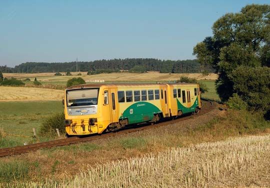
factors listed above.As of the end of 2016, the STARS measurement campaigns have started (see Fig. 2) in three countries
(Czech Republic, Switzerland, Italy). The selected lines and vehicles represent the various types of rail
environments in Europe (e.g. open environment, urban and mountainous areas etc.), as well as traction
systems (AC/DC electric traction, diesel traction).
Collected data (raw GNSS signals as well as data from a number of receivers) are continuously being
uploaded to a centralised, cloud-based repository, giving easy access to all project partners across Europe
to perform the individual types of analysis.
Fig. 2: STARS measurement campaign – examples of vehicles and environments
Ambitions and expected impacts
The project aims to improve ERTMS through the application of GNSS, leading to economic benefits
through reduction of trackside equipment, reduction of maintenance, increase of availability and
performance. The output of the project will feed directly into the standardisation work of ERTMS, and
shall become part of an upcoming release of the standard.
The STARS project is based on (but not limited to) the theoretical work produced by previous research
projects such as NGTC2 or ERSAT-EAV. Its results will be effectively utilised by ongoing and future
linked R&D projects, most significantly Shift2Rail JU3 (see Fig. 3).
2
NGTC website: www.ngtc.eu
3
Shift2Rail JU website: www.shift2rail.orgFig. 3: Major links between STARS and other projects / initiatives Acknowledgement The STARS project has received funding from the European Union's Horizon 2020 research and innovative program under grant agreement No. 687414.
You can also read