STATE OF OKLAHOMA OKLAHOMA MINING COMMISSION DEPARTMENT OF MINES - HONORABLE J. KEVIN STITT
←
→
Page content transcription
If your browser does not render page correctly, please read the page content below

STATE OF OKLAHOMA
    HONORABLE J. KEVIN STITT
         GOVERNOR

OKLAHOMA MINING COMMISSION
    DEPARTMENT OF MINES
      103rd Annual Report
       Calendar Year 2019

       Mary Ann Pritchard
            Director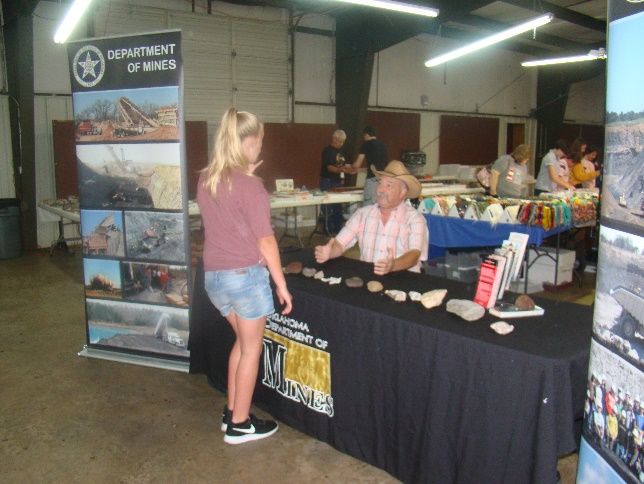
ANNUAL REPORT

                   2019

As authorized by Mary Ann Pritchard, Director

   In compliance with Title 45, Section 31,
             Oklahoma Statutes

You can review this report on our website at
            www.ok.gov/mines
                     or
Copies of this report may be obtained from

     Oklahoma Department of Mines
  2915 North Classen Boulevard, Suite 213
     Oklahoma City, Oklahoma 73106

               405.427.3859
             405.427.9646 Fax
             405.424.4932 Fax
Table of Contents

Mining in Oklahoma – Overview . . . . . . . . . . . . . . . . . . . . . . . . . . . . . . . . . . 1
Oklahoma Department of Mines Key Personnel . . . . . . . . . . . . . . . . . . . . . 2
Office of Chief Mine Inspectors / Directors . . . . . . . . . . . . . . . . . . . . . . . . 3
State Mining Board/Oklahoma Mining Commission . . . . . . . . . . . . . . . . . 4
Oklahoma Mining Commission 2019 . . . . . . . . . . . . . . . . . . . . . . . . . . . . . . 5
Oklahoma Miner Training Institute . . . . . . . . . . . . . . . . . . . . . . . . . . . . . . . . 6
Mine Health & Safety Conference / Safety Awards . . . . . . . . . . . . . . . . . . . 7
Public Service / Student Outreach 2019 . . . . . . . . . . . . . . . . . . . . . . . . . . . 8-13
Geology & Mineral Resources of Oklahoma . . . . . . . . . . . . . . . . . . . . . . . . . 14
Oklahoma Mining Production 2019 . . . . . . . . . . . . . . . . . . . . . . . . . . . . . . . . 15-16
Oklahoma Remaining Coal Resources . . . . . . . . . . . . . . . . . . . . . . . . . . . . . . 17-19
Coalbed Information . . . . . . . . . . . . . . .. . . . . . . . . . . . . . . . . . . . . . . . . . . . . 19-22
Coal Production 2019 . . . . . . . . . . . . . . .. . . . . . . . . . . . . . . . . . . . . . . . . . . . . 23
Coalbed Production 2019 . . . . . . . . . . . . . . . . . . . . . . . . . . . . . . . . . . . . . . . . 24
Surface & Underground Tonnage Comparison . . . . . . . . . . . . . . . . . . . . . . . 25-27
Major Mining Disasters in Oklahoma . . . . . . . . . . . . . . . . . . . . . . . . . . . . . . . 28
Non-Fuel Minerals / Minerals Permits . . . . . . . . . . . . . . . . . . . . . . . . . . . . . . 29
Asphalt / Bentonite / Caliche Production . . . . . . . . . . . . . . . . . . . . . . . . . . . 30
Chat Production / Clay Production . . . . . . . . . . . . . . . . . . . . . . . . . . . . . . . . 31-32
Copper Production / Dimensional Stone . . . . . . . . . . . . . . . . . . . . . . . . . . . . 32
Granite/Gypsum/Iron Ore Production . . . . . . . . . . . . . . . . . . . . . . . . . . . . . . 33
Gypsum / Iron Ore / Lead & Zinc Production . . . . . . . . . . . . . . . . . . . . . . . . . 34
Limestone Production . . . . . . . . . . . . . . . . . . . . . . . . . . . . . . . . . . . . . . . . . . . 34-35
Salt Production . . . . . . . . . . . . . . . . . . . . . . . . . . . . . . . . . . . . . . . . . . . . . . . . . 35-36
Sand & Gravel Production . . . . . . . . . . . . . . . . . . . . . . . . . . . . . . . . . . . . . . . 36-37
Select Fill Production . . . . . . . . . . . . . . . . . . . . . . . . . . . . . . . . . . . . . . . . . . . 37-38
Shale Production . . . . . . . . . . . . . . . . . . . . . . . . . . . . . . . . . . . . . . . . . . . . . . 38-39
Tripoli / Volcanic Ash Production . . . . . . . . . . . . . . . . . . . . . . . . . . . . . . . . . . 39
Acknowledgements / Sources . . . . . . . . . . . . . . . . . . . . . . . . . . . . . . . . . . . . . 40

                                                           i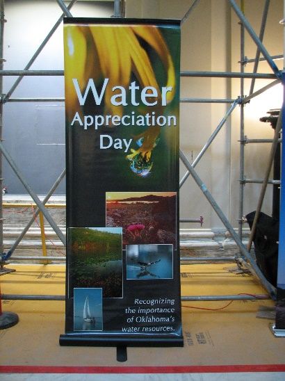
MINING IN OKLAHOMA – OVERVIEW

       The Oklahoma mining industry has been very important to Oklahoma since before
statehood. Currently, mining provides the basic raw materials for all of the products that we
require so that: “If it is not grown, it must be mined”.

        The Oklahoma Department of Mines regulates the production of solid minerals in the
state, including coal and non-fuel minerals (crushed stone/limestone, granite, sand/gravel,
clay/shale, dimensional stone, gypsum, salt, tripoli, asphalt, bentonite, copper, iron ore, volcanic
ash, lead/zinc, and chat). The Oklahoma Corporation Commission regulates the production of
the liquid and gaseous minerals in the state including iodine and helium, which are non-fuel
minerals whose values are included below in the national statistics for non-fuel minerals used in
this report. The Oklahoma Corporation Commission also regulates the production of the fuel
minerals, oil and natural gas, which are reported as a separate Oil/Gas category for state and
national statistics and are not included in the non-fuel mineral production report totals.

        In 2019, Oklahoma ranked 29th in the U.S. for non-fuel mineral production with a value
of $1,070 million or 1.24 % of the U.S. total, according to the National Mining Association.
Oklahoma coal production significantly decreased to 294,334 in 2019 from 639,462 thousand
tons in 2018.

        Mining production in Oklahoma is expected to grow due to increased need for major
repairs and expansion of Oklahoma’s highway and bridge infrastructure.

        The Oklahoma mining industry has an excellent record of safety and environmental
responsibility. Nationally, mining safety has been greatly improved from its past history. In
2019, according to Mine Safety & Health Administation (MSHA), Oklahoma reported one fatality
in non-coal/metals in the mining industry. While the potential hazards at mines still exist, the
continuing diligent efforts of all the mining companies and their employees are proving of great
value for achieving productive, safe, and environmentally responsible mining.

                                                 1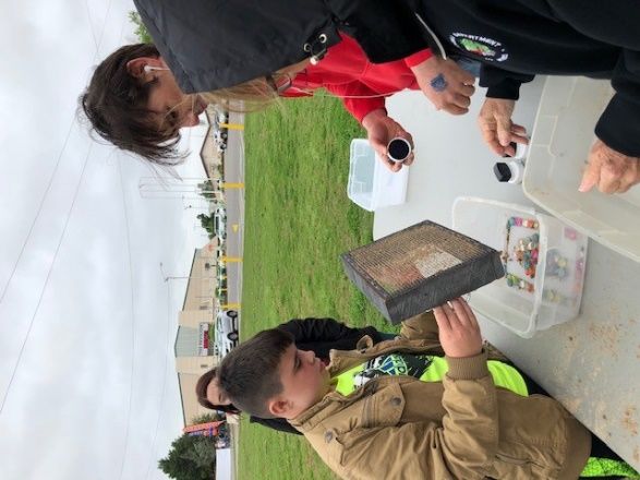
OFFICE OF THE DIRECTOR - STATE OF OKLAHOMA
                     DEPARTMENT OF MINES - KEY PERSONNEL

       Director ………………………….…………………………………                   Mary Ann Pritchard
       Deputy Director ……………..……..……………………….…              Doug Schooley
       Minerals Division Administrator …………………………          Richard Shore
       Coal Program Director ……..…………………..………….            Rhonda Dossett
       Chief Counsel …………………………………………………….                 Mark Secrest
       Chief Financial Officer ………………………………….…..           Suzen Rodesney

                          OKLAHOMA DEPARTMENT OF MINES

        The Office of the Chief Mine Inspector was created before statehood for the safe
operation of mines and the protection of the health of those employed in the mines. The
territorial years were well noted for the many mining disasters, and officials were busied with
the necessary investigations and recommendations following each serious or fatal accident. Over
the years, major revisions in mining health and safety laws and the increase in surface mining
versus underground mining helped to decrease mining fatalities in Oklahoma.

       The extraction or mining of minerals from the earth occurs in every county of the state.
Minerals mined in Oklahoma include coal, limestone, sand and gravel, gypsum, clay and shale,
granite, volcanic ash, tripoli, salt, bentonite, iron ore, asphalt, copper and chat.

       Before commencement of mining operations, a permit must be obtained from the
Department. A permit is issued when the mine operator submits an acceptable application and
posts adequate bond to cover reclamation costs should it be necessary for a third party to
complete the reclamation process. The mining operator's permit application must include the
requirements for legal and financial compliance, the safeguard of environmental resources, and
an operations and reclamation plan. Before opening the site, the employees of the mining
operation must be trained and certified in accordance with state and federal safety regulations.
Mining practices, reclamation, and health and safety procedures are monitored on a regular basis
by Department inspectors.

        The general provisions of Title 45 O.S. address health and safety on the mine site and
reclamation of mined land. In 1967, the Oklahoma Legislature passed the state's first reclamation
law which became effective January 1, 1968. That law was replaced in July 1971 with the Mining
Lands Reclamation Act, which requires better reclamation in general and includes all mining.
Until the passage of such legislation, however, 17,000 acres had been mined with little or no
reclamation. This Act is still in effect for non-coal lands.

                                               2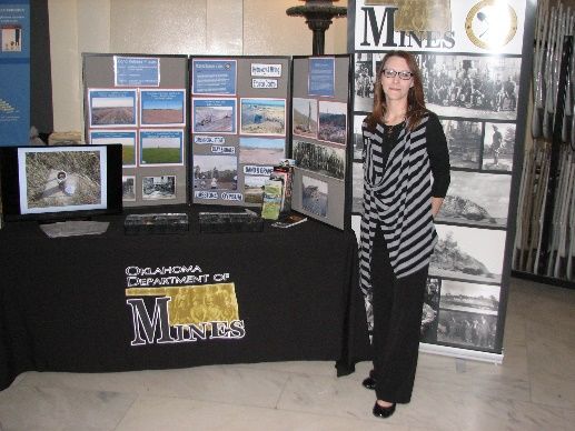
The Surface Mining Control and Reclamation Act of 1977 was created by Congress with
the passage of Public Law 95-87. Subsequently, the State of Oklahoma enacted further legislation
to equal the enforcement ability of the federal government. The Coal Reclamation Act of 1978
enabled Oklahoma to operate the interim program law and regulations (Section 715, CFR 30)
under P. L. 95-87. It was followed by permanent standards adopted in 1979.

                        OFFICE OF CHIEF MINE INSPECTOR ABOLISHED

       In 1986, State Question 594 was passed by the Oklahoma voters. This amended sections
of the Oklahoma Constitution by removing all mention of the Chief Mine Inspector. The
Department of Mines is now administered by a Director chosen by the Mining Commission. The
Director must be knowledgeable of the Oklahoma mining industry and have the ability to
administer the functions of the Department.

                                DIRECTORS, DEPARTMENT OF MINES
       Gayle Townley    ............................................................................ 1986 -- 1987
       Bennie Cox .................................................................................. 1987 -- 1993
       James Hamm .................................................................................. 1993 -- 1998
       Mary Ann Pritchard ...................................................................... 1998 -- Present

                                          CHIEF MINE INSPECTORS
       Pete Hanraty .................................................................................. 1907 -- 1910
       R. W. Church .................................................................................. 1910 -- 1911
       Ed Boyle      .................................................................................. 1911 -- 1927
       Miller D. Hay .................................................................................. 1927 -- 1931
       Robert Brown .................................................................................. 1931 -- 1947
       John M. Malloy................................................................................. 1947 -- 1963
       Ward Padgett .................................................................................. 1963 -- 1980
       Otis English .................................................................................. 1980 – 1980

                                   DEPUTY CHIEF MINE INSPECTORS
       Blaney Qualls ................................................................................. 1980 -- 1984
       Gayle Townley ................................................................................. 1984 -- 1986

                                          TERRITORIAL DIRECTORS
       Luke W. Bryan                 ....................................................................... 1894 -- 1901
       William Cameron               ....................................................................... 1901 -- 1907

                                                               3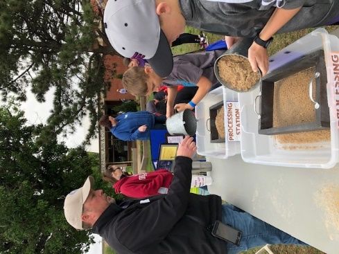
STATE MINING BOARD

       The State Mining Board was established at statehood with the express purpose of testing
and certifying persons who would hold the important positions of mine superintendent, foreman,
hoisting engineer, and fire boss. The Board was later given additional responsibilities: to
promulgate and enforce rules and regulations with regard to the health and safety of persons
employed in the mines, to issue or revoke certificates of competency for surface and
underground mine positions, to require the submission and review of plans and specifications for
underground mine ventilation and safety and to recommend approval or denial of such plans to
the Chief Mine Inspector. In addition, the Board acted as mediator between miners and
operators on matters of health and safety; the decision of the Board was binding unless
overturned by an opinion of the Attorney General or by a court of law.

        As revised by the 1982 Legislature, the Mining Board was composed of ten members.
Four of the members were strip miners, of which at least two represented the industry mining
non-coal minerals. Two members were practical miners, who held either underground mine
superintendent, mine foreman, or fire boss certification. Two members were owners or
superintendents of coal mines. One member was a non-supervisory miner who was actively
employed in an underground coal mine for at least five years and held a minimum of a fire boss
certificate. The last member was the Chief Mine Inspector, who was the executive officer of the
Board.

                        THE OKLAHOMA MINING COMMISSION

        In 1985, the State Legislature abolished the State Mining Board and replaced it with the
Oklahoma Mining Commission. This nine member board, which held its first meeting in January,
1986, is the policy-determining body of the Department of Mines and determines the broad plans
and programs for the Department.

        The membership of the Commission consists of one person with a background in
engineering or geology; one person with a background in labor or worker's safety; one person
with a background in agriculture or soil conservation; one person with a background in
transportation; one person with a background in economic development or banking; one person
with a background in public utilities; one person with a background in natural resources; and two
persons selected at large.

                                               4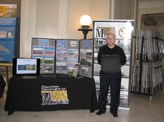
OKLAHOMA MINING COMMISSION - 2019

J. Clement Burdick III, Vice Chairman ............................... Edmond, OK
Position #1; Engineering/Geology
Kurt Klutts, ………………………….………………………………………… Poteau, OK
Position #2; Labor/Worker’s Safety
George E. Fraley, Chairman .............................................. Chelsea, OK
Position #3; Agriculture/Conservation
B. Dave Donoley ………….................................................... Wilburton, OK
Position #4; Transportation
Jed W. Winters ……………………………………………………………… Mangum, OK
Position #5; Banking/Economic Development
Tommy R. Caldwell ………………………………………………………….. Shady Point, OK
Position #6, Public Utilities
John R. Curtis ....................................................................... Broken Arrow, OK
Position #7; Natural Resources
Ronald R. Cunningham, Secretary …………………………………… Hartshorne, OK
Position #8; At-Large
Mark A. Helm .……………………................................................ Sulphur, OK
Position #9; At-Large

                                           5
OKLAHOMA MINER TRAINING INSTITUTE

        The Oklahoma Miner Training Institute (OMTI) is operated under the direction of the
Oklahoma Mining Commission. The Institute, located at Eastern Oklahoma State College in
Wilburton, OK provides training in all aspects of mine safety and health. Regularly scheduled
classes are provided at the school, or at the mine sites throughout the state to minimize the
inconvenience to both miners and operators.

                                 Courses Offered by OMTI

Annual Refresher Training (Surface)               New Miner Training #1 (Surface)
Annual Refresher (Underground)                    New Miner Training #2 (Surface) Blasting
Cardiopulmonary Resuscitation (CPR)               New Miner Training (Underground)
(CPR) Refresher                                   State and Federal Regulations
Electrical Retraining                             State Surface Certification
Fire Prevention and Control                       State Surface Certification Refresher
First Aid (Initial)                               Surface Blasters Refresher
First Aid (Refresher)                             Surface Blasters Initial
Instructor Training

                                      OMTI Personnel

                         Clarence “Buzz” Stanley, Executive Director
                                   Chassey Kirk, Secretary
                                Danny Thornburg, Instructor

                      OKLAHOMA MINER TRAINING INSTITUTE
                            2019 ANNUAL REPORT
                            # Miners Trained             Total #            Total #
       Year          Coal          Metal/Non-Metal      Of Classes     Classroom Hours
       2019           56                  2,554            168               1,528

                                             6
OKLAHOMA MINE HEALTH AND SAFETY CONFERENCE

         The State of Oklahoma is one of a very few states that has its own Mine Health and Safety
Conference. For the past several years, the Oklahoma Miner Training Institute and the Oklahoma
Department of Mines have joined with the Mine Safety and Health Administration (MSHA) to co-
host this conference. The purpose of the conference is to combat health and safety issues that
plague the mining industry. This conference is usually held in the fall of the year at a designated
site in Oklahoma. As many as twelve other mining states come to Oklahoma to attend beneficial
workshops and receive recognition awards for their safety efforts.

                           ODM INSPECTOR’S SAFETY AWARDS

In 2006, the Oklahoma Department of Mines created the Inspector’s Safety Award. Since its
inception, 270 awards have been earned by mine operators across Oklahoma. Recipients are
chosen on an established set of criteria to reward operators for safe mining practices. These
criteria include number of violations, reduction in violations from the previous year, and
warnings. The awards are presented each year at the Oklahoma Mine Health & Safety
Conference. ODM decided to make the awards more visible by using 30” by 36” road signs
produced by the Oklahoma Department of Transportation’s Sign Shop. These awards are much
coveted, and ODM is proud to recognize these operators who make safety a priority.

                           2019 INSPECTOR’S SAFETY AWARDS

                  Small Mines                                     Large Mines
   Rock-It Natural Stone, Inc. (Big Hill #2)        Solid Rock Stone, Inc. (Calhoun Mine)
   Cullum Equipment (Hanson Mtn. Quarry)            APAC-Central, Inc. (Muskogee Sand Plant)
   APAC-Central, Inc. (Oologah Facility)            APAC-Central, Inc. (Vinita Quarry)
   CP Materials, LLC                                Dolese Bros. Co. (Roosevelt Quarry)
   Unimin Corp. (Roff Plant)                        TXI Operations, LP (Mill Creek Quarry)
   Yote Stone (Yote #1)                             Rock-It Natural Stone (Tamaha #1)
   HSG Acquisition (Coweta Plant #10)               Muskogee Sand Co., Inc.
   J.R.’s Sand – John Vestle                        Cargill, Inc.
                                                    Dolese Bros. Co. (White Eagle Sand Plant)

                                                7
SAFETY COMMITTEE
The Oklahoma Mining Commission established a Safety Committee in March 2000. This
committee creates and produces monthly “Safety-Grams” for distribution to all mining
permittees and operators in Oklahoma. Safety-Grams have been published since 2000. The
Safety-Grams cover basic first-aid, safe operation of mining equipment, and compliance with
Oklahoma mining rules and regulations. Safety-Grams are distributed on mine sites, so all mine
employees have access to the information. Each Safety Gram is also posted on our website at
www.ok.gov/mines under publications.
PUBLIC SERVICE
In April 2000, The Oklahoma Department of Mines presented its first Student Outreach
Program. The program is designed to provide Oklahoma students and teachers with a better
understanding of the mining process in Oklahoma. The Department conducted the following
public/student outreach presentations during 2019:
_____________________________________________________________________________
Bixby High School 2019
April 11, 2019
9:30 a.m. – 3:00 p.m.
On Thursday, April 11, 2019, the Oklahoma Department of Mines (ODM) made presentations at
Bixby High School, teaching students about the phases of mining and reclamation activities. We
also discussed the importance of safety regulations on mine sites and discussed blasting
requirements. ODM personnel participating in this event were Inspector Kevin Woody, Coal
Permit Officer Stacy Woody and OMTI Director Clarence Stanley. The students were divided into
two classes. One session was from 9:30 a.m. – 11:30 a.m. and the second session was from 1:00
p.m. until 3:00 p.m. Approximately eighty 11th grade students participated.
8Water Appreciation Day
April 17, 2019
Oklahoma State Capitol
The 14th Annual Oklahoma Water Appreciation Day was held at
the Oklahoma State Capitol on April 17, 2019. Geologist Darrell
Shults and Records Management Specialist Ginna Harmon
represented the Oklahoma Department of Mines for this event.
Participants included
state, local and federal
government agencies,
academic groups, and environmental groups. All groups
attending either study or regulate water quality or
quantity, or advocate for water issues. Each entity
showcased its involvement in managing, studying and
improving Oklahoma’s water resources.
Government officials, teachers, lobbyists, the press,
students, and the general public were in attendance. Notables included Ken Wagner, Oklahoma’s
Secretary of Energy & Environment.
Most attendees were interested in ODM’s rock display. A
PowerPoint presentation highlighting ODM’s water
management and reclamation efforts was presented via a
laptop computer. Some individuals took ODM brochures
detailing our mission statement, coal and non-coal
permitting and bond release process, blasting permit
process, and the OMTI training program.
9ScienceFest 2019
May 2, 2019
8:00 a.m. – 3:00 p.m.
On May 2, 2019, the Oklahoma Department of Mines (ODM)
manned an activity station at the Oklahoma City State Fairgrounds
for ScienceFest 2019. Assisting Student Outreach Coordinator
Stacy Woody with this event were ODM staff members Kevin
Woody, Linda Landon, Justin Maxey, Troy Young, and Ginna
Harmon, along with OMTI Director Clarence Stanley, and volunteer
Sherry Stanley.
The ODM activity station was entitled “Mining for Marbles”. The
students mined the marbles, processed their materials, and cashed
in at the market station for an “Honorary Oklahoma Miner” hand
stamp. The station was intended to give the students a sense of the mining process.
Approximately 3500 fourth, fifth, and sixth graders from area schools attended this annual
event. This was 1,000 more students from the last ScienceFest in 2017. There were 46 activity
stations covering topics such as air, water, wildlife, agricultural earthquakes, and forestry. The
students participated in numerous environmental activities related to science and natural
resources protection.
10South Central Joint Mine Health & Safety Conference
April 15-18, 2019
The 37th annual South Central Joint Mine Health and Safety
Conference was held in Dallas, Texas April 15 – 18, 2019, at the
Hilton Anatole. This grand facility accommodates many
conference goers. This year, the mining group numbered about
325. Several Oklahoma mining companies attended and/or
sponsored this multi-state event. There were approximately 27
vendors in the exhibit hall. The Oklahoma Department of Mines
(ODM) was among the exhibitors. Our booth was manned by ODM
Coal Permit Officer Stacy Woody and ODM Inspector Kevin Woody.
There was information on ODM’s programs, ODM Safety Grams
and Oklahoma’s Surface Safety Standards. ODM’s operational
information cards and our new reflective hardhat stickers were
distributed. The booth and the participants represented ODM very
professionally.
The ODM conference attendees were Director Mary Ann Pritchard and Minerals Division
Administrator Richard Shore along with OMTI Director Clarence (Buzz) Stanley.
A wide range of subjects was offered during the daily workshops with many informative
presentations. One presentation called Leading the Way was led by Mr. Keni Thomas, retired
Staff Sargent 3rd Army Ranger Battalion, who discussed his BlackHawk Down experience as an
approach to leadership. Mr. David P. Liffig, the keynote banquet speaker, discussed his passion
about workplace safety and how his concept of The Magic of Zero has positively affected
individuals and organizational leadership.
During the awards luncheon, eight (8) safety mining awards were given to individuals who had
no lost time accidents with a minimum of 36 years’ service in the industry. There was one
individual with 42 years with no lost time accidents.
One of the most important aspects of this conference is to
network with colleagues, as well as discussing national issues
with MSHA representatives. Notable MSHA attendees
included Mr. William O’Dell, South Central District Manager
and Mr. Wayne Palmer, Deputy Assistant Secretary from
Arlington, Virginia.
11Tahlequah Rock & Mineral Show 2019
August 23, 2019
8:30 a.m. – 4:30 p.m.
On Friday, August 23, 2019, the Oklahoma
Department of Mines (ODM) attended the
Tahlequah Rock and Mineral Show (TRAMS)
2019. ODM personnel spoke to area students
about the phases of mining and the importance
of safety regulations on mine sites. ODM
personnel participating in this event were
Inspector Kevin Woody and Coal Permit Officer
Stacy Woody.
ODM’s activity station included the photographic
display of the different phases of mining,
reclamation, and blasting. Inspector Woody answered questions related to mining and the
importance of reclamation to prevent negative environmental impacts on the land. The Coal
Permit Officer set up displays, took photos and was on hand to answer questions. Literature
related to mining and the agency was available.
Approximately 100 students from area schools attended this annual event. The students
participated in numerous environmental education activities related to science and natural
resources protection.
12Tulsa Global Alliance - Mongolian Delegation
October 4, 2019
On Friday, October 4, 2019, Richard Shore, Administrator of Minerals Program, and
Rhonda Dossett, Coal Program Director, spoke to a group from Mongolia about Oklahoma
mining. Mr. Bob Lieser, Vice President of Programs for Tulsa Global Alliance requested that the
Oklahoma Department of Mines meet with the Mongolian delegation. The group was in the
United States at the invitation of the State Department to learn about United States mining
policies and in particular mining policy at the state level.
Mr. Shore and Ms. Dossett spoke for 90 minutes on permitting, inspection, pre and post
mining environmental testing and analysis, blasting, and citizen, landowner, and royalty owner
involvement in permitting and bond release. The ODM representatives presented the group with
copies of mining regulations, permit applications, and outreach handouts on bond release,
permitting, and citizen complaints.
Only a few of the attendees spoke English, but the interpreters were very helpful. The
translations were simultaneous and the group was given opportunities to ask questions. The
group was particularly interested in learning the names of: suppliers of mining equipment, large
mining companies who might be interested in Mongolian mining, and exchange programs
between Oklahoma and Mongolia.
The following Mongolian individuals participated in the workshop held at OSU Tulsa on
Greenwood, along with three Mongolian interpreters:
• Ms. Tumendelger Baljinnyam, Senior Officer, Research / Analysis Department,
Regulatory Agency of Mongolian Government, National Development Agency
• Dr. Bayarsaikhan Banzragch, Chairman, National Development Agency
• Mr. Zayabal Batjargal, Commissioner, General Department of Taxation
• Mr. Batbold Eerdenbileg, Director General,
Strategic Policy and Planning Department, Ministry of Mining and Heavy Industry
• Mr. Tuguldur Gur Aranz, Minister Advisor, Ministry of Mining and Heavy Industry
• Mr. Munbat Lkhagvaa, Director,
Investment Policy and Coordination Department, National Development Agency
• Mr. Gankhuleg Munguntsog, Advisor, Cabinet Secretariat Chief, Cabinet Secretariat
• Ms. Orkhon Namkhai, Director,
Public Administration Department, National Development Agency
• Mr. Dashdemberel Natsagdorj, Senior Officer,
Investment Policy and Coordination Department, National Development Agency
• Mr. Munkhtur Ochirjantsan, Head,
Public-Private Partnerships Division, National Development Agency
13GEOLOGY AND MINERAL RESOURCES OF OKLAHOMA
Geology
Oklahoma is a region of complex geology where several major sedimentary basins are set
among mountain ranges and uplifts. The state contains many classic areas where fundamental
concepts of geology, petroleum exploration, and mineral production have been formulated
through the years. Because of its geologic history, Oklahoma has abundant mineral resources
that include petroleum (crude oil and natural gas), coal, non-fuel minerals (lead, zinc, gypsum,
limestone, salt, sand and gravel), and water.
Geologic forces deep within the earth’s crust hundreds of millions of years ago caused
portions of Oklahoma to subside as major sedimentary basins, while adjacent areas were folding
and thrust upward as major mountain uplifts. Most of the outcropping rocks in Oklahoma are of
sandstone, limestone, and gypsum. These sedimentary rocks typically are 2,000-10,000 feet thick
in the northern shelf areas, and they increase sharply to 30,000-40,000 feet thick in the deep
basins of the south. These sedimentary rocks contain most of the state’s mineral resources,
including petroleum, coal, water, and most of the non-fuel minerals. Sedimentary rocks rest
upon a “basement” of igneous and metamorphic rocks that underlie all parts of the state.
Exposed in the southern Oklahoma mountain belts are a great variety of sedimentary and
igneous rock units seen at few other places in the entire mid-continent region. Steeply dipping
strata, such as those exposed along Interstate 35 through the Arbuckle Mountains, attest to the
strong geologic forces that folded and raised the mountain blocks. Outcropping rocks outside
the mountain regions are essentially horizontal, with dips of less than one degree being most
common. These strata typically form gently rolling hills and plains: thick shale units form broad,
flat plains and valleys, where resistant layers of sandstone and limestone cap mesas, cuestas, and
hills 100-500 feet high. Rocks and soils of western Oklahoma typically are red in color, due to
oxides present in the bedrock, whereas rocks and soils elsewhere are shades of brown, gray, and
black.
14Oklahoma Mining Production - Tons
2019
Tripoli 50,269
Shale 566,829
Caliche 6,246
Select Fill 1,020,763
Sand & Gravel
19,255,178
Chat 142,777
Clay; 1,661,423
Coal; 294,334
Salt; 166,037 Dim Stone; 1,121,896
Granite; 9,629,110
Gypsum; 5,280,332
Limestone; 42,544,765
Caliche Chat Clay Coal Dim Stone
Granite Gypsum Limestone Salt Sand & Gravel
Select Fill Shale Tripoli
15STATE OF OKLAHOMA
PRODUCTION 2019
Product Mined 2019 Production
Caliche 6,246
Chat 142,777
Clay 1,661,423
Coal 294,344
Dimensional Stone 1,121,896
Granite 9,629,110
Gypsum 5,280,332
Limestone 44,544,765
Salt 166,037
Sand & Gravel 19,255,178
Select Fill 1,020,763
Shale 566,829
Tripoli 50,269
Total Production 83,739,959
16OKLAHOMA COAL RESOURCES
COAL
Oklahoma fuel resources include coal, oil, and natural gas. Coal mining is regulated by
the Oklahoma Department of Mines and is discussed below. Oil and natural gas production are
regulated by the Oklahoma Corporation Commission and are not discussed in this report.
Identified coal resources are present in an area of approximately 8,000 square miles in 20
counties in eastern Oklahoma. The area is within the southern part of the Western Region of the
Interior Coal Province of the United States. The coal beds are of Middle and Late Pennsylvanian
age, 0.8-10 ft thick, 0.4-6.5% in sulfur content, coking or non-coking, contain 11,400-15,000
Btu/lb, and are low (2-7%) in inherent moisture. Oklahoma contains the most significant deposits
of bituminous coal between the Mississippi River and the Rocky Mountains. Although the
McClellan-Kerr Arkansas River Navigation System is available for barging coal to international
ports, most coal production is shipped by truck or rail. As of January 1, 2007, 8.1 billion short tons
of remaining coal resources have been identified; 76% are in the Arkoma basin and 24% are in
the northeast Oklahoma shelf area. About 41% of the state’s coal resources are low- and
medium-volatile bituminous in rank and are present in the Arkoma basin. Four mining companies
produced 294,334 tons of coal at four mine sites in four counties in 2019.
The bituminous coals of the state are low volatile in northern LeFlore County; medium
volatile in northern LeFlore, Sequoyah, and most of Haskell Counties; high volatile A and B in
Craig and Nowata Counties, parts of Haskell County, and in most of the remaining coal-bearing
counties; and high volatile C in Coal and Pittsburg Counties.
The commercial coalbeds in the Northeast Oklahoma Shelf area are 0.8-5.0 feet thick,
average 2.0 feet thick, dip westward from ½ degree to 2 degrees, and contain more than 3
percent sulfur by weight with the exception of the low-sulfur Croweburg and Secor coals. The
coalbeds in the Arkoma Basin area are 1-10 feet thick and occur in eroded anticlines and synclines
that trend northeastward. The coals crop out mostly along the sides of these folded and faulted
structures, and their dip ranges from 3 degrees to nearly vertical.
The face cleat trend is northwestward in the coal beds of the Shelf and the Basin. In the
Arkoma Basin, coals that exhibit steep dips (18 degrees to 65 degrees) commonly were mined
before 1960. From 1960 to 1974, no mines were developed in steeply dipping coalbeds because
of cost. The Arab oil embargo of 1973 resulted in increases in demand and prices for coal. Thus
from 1974 to 1984, seven surface mines were developed in steeply dipping coalbeds in the
Arkoma Basin, and they produced coking and metallurgical coal in which the sulfur content was
only 1%. Coal from steeply dipping beds has not been mined since 1984 because of the high cost.
Of the remaining coal resources in the state, 76% are in the Arkoma Basin and 24% are in the
Shelf area. The weighted average sulfur content of the total remaining coal resources is 2.3%.
17Remaining Identified (Bituminous) Coal Resources in
Oklahoma - January 1, 2007
County Short Tons(thousands)
Atoka 29,619
Coal 292,875
Craig 638,560
Creek 15,573
Haskell 1,509,081
Latimer 840,492
LeFlore 1,962,725
Mayes 31,094
McIntosh 36,319
Muskogee 95,531
Nowata 27,829
Okfuskee 155,964
Okmulgee 339,909
Pittsburg 1,383,833
Rogers 360,183
Sequoyah 27,146
Tulsa 169,974
Wagoner 128,945
Washington 23,450
Total 8,069,102
Approximately 680 million tons of Oklahoma's remaining coal resources were estimated
(Friedman, 1974) as strippable from beneath 100 feet or less of overburden, in beds 12 inches or
more in thickness. Strippable coal resources were reported in Atoka, Coal, Craig, Creek, Haskell,
Latimer, LeFlore, Mayes, McIntosh, Muskogee, Nowata, Okfuskee, Okmulgee, Pittsburg, Rogers,
Sequoyah, Tulsa, Wagoner, and Washington Counties in 25 different coalbeds. The
Demonstrated Reserve Base (DRB) shows 342 million tons as strippable (U.S. Department of
Energy, 1996).
In 1986, the major use of Oklahoma coal was by out-of-state electric power generating
plants, and the major use of Oklahoma coal in Oklahoma was in cement and lime kilns, at a paper
plant, and for process heat at an auto assembly plant. In 1987, however, state law required
blending 10% of the BTU value of total non-Oklahoma (Wyoming) coal consumed at Oklahoma
power plants with Oklahoma coal. Consequently, a significant change took place in the
distribution of Oklahoma coals by the end use. By 1991, more than 50% of Oklahoma coal
production was shipped to Oklahoma electric power plants. Although the 1987 “10%” law was
declared unconstitutional by the U.S. Supreme Court in January 1992, the 1991 Oklahoma coal
production increased 16% from 1990.
18This is explained by a shift in shipments of Oklahoma coal in 1991 to the AES Shady Point
fluidized-bed combustion power plant in LeFlore County. Nevertheless, about 18 million tons of
low-sulfur (0.4%) subbituminous Wyoming coal was shipped to Oklahoma public utilities in 1997.
Oklahoma power plants rank fourth among the states consuming coal imported from Wyoming.
Cumulative coal production in Oklahoma (1873-2019) is 302.3 million tons.
COALBEDS
A total of 25 named bituminous coal beds are present and have been mined in eastern
Oklahoma. Most past production has been from the Hartshorne, Lower Hartshorne, McAlester,
and Croweburg Coals, which were mined by underground methods. Coal rank, generalized for
all coals at or near the surface, ranges from high-volatile bituminous in the northeast Oklahoma
shelf and western Arkoma Basin to medium-volatile bituminous and low-volatile bituminous in
the eastern Arkoma Basin in Oklahoma. Rank increases from west to east and with depth in the
Arkoma Basin, attaining semianthracite in Arkansas.
HARTSHORNE COAL
At the southern edge of the coal region in Oklahoma, the Hartshorne Coal commonly is
split into two beds by shale and sandstone that are 1 to 100 feet thick. The two beds are called
the Upper and Lower Hartshorne Coals, and they have been extensively mined. North of the
position of the long axis of the Arkoma Basin, the Hartshorne Coal is not split but is a single bed
1 to 7 feet thick containing, in most places, a persistent black shale or mudstone parting about 1
to 5 inches thick. Core drilling and successful efforts at underground mine development since
1969 have demonstrated significant underground coal resources in the Hartshorne Coal in areas
19in Haskell and LeFlore Counties, where it is 3 to 7 feet thick, of low or medium-volatile bituminous
rank, and an excellent coking coal. In 2019, two mining companies produced 115,677 tons of
Hartshorne coal at two mine sites.
LOWER HARTSHORNE COAL
Mined in the Arkoma Basin mostly for metallurgical coke manufacture for 115 years, the
Lower Hartshorne Coal has been shipped to electric power plants since 1985. Hundreds of
underground mines, many of them referred to as no more than “dog holes”, have been
developed along the 120 miles of outcrop of the Lower Hartshorne Coal since 1872, at which time
a railroad first connected McAlester, Pittsburg County, with Arkansas, and thus with the other
states. The Lower Hartshorne Coal is 0.8 to 7.0 feet thick, averaging 4 feet in underground mines.
The railroads used this premium-grade coal for steam, but historically the coal was shipped to
blast furnaces in Colorado, Ohio, Pennsylvania, Texas and Japan. The Lower Hartshorne Coalbed
contains at least 1,541,000 tons of remaining coal resources (Friedman, 1974), and it also
contains coalbed methane resources.
UPPER HARTSHORNE COAL
The Upper Hartshorne Coal was once extensively mined at outcrops on the flanks of
anticlines in LeFlore, Haskell, Latimer and Pittsburg Counties. It is 2 to 4 feet thick and is low- or
medium-volatile bituminous in rank in the east end of the Arkoma Basin and high-volatile in the
west end. The Upper Hartshorne Coalbed contains 663 million tons of remaining coal resources
(Friedman, 1974), and it also contains coalbed methane resources.
McALESTER COAL
The McAlester Coalbed has been extensively mined by underground methods at
McAlester in central Pittsburg County and in southeastern Coal County. Throughout the Arkoma
Basin, the McAlester Coalbed is 1.5 to 5.0 feet thick and mostly high-volatile bituminous in rank.
The coal is thickest in Coal and Pittsburg Counties. It is suitable for use in electric power
generation, for blending with higher rank coal for coke manufacture, in cement and lime
manufacture, and it is suitable for gasification and liquefaction conversion processes. The
McAlester Coal contains 1,012,000 tons of remaining resources (Friedman, 1974), and it contains
significant coalbed methane resources in places where it is 3 to 5 feet thick.
STIGLER COAL
Correlated with the McAlester Coal (Friedman, 1978), the Stigler Coal has been mined
historically to depths of 30 to 45 feet by surface methods in Haskell, LeFlore, Muskogee and
Sequoyah Counties. The Stigler Coal was mined to 100 feet in Sequoyah County and to 140 feet
in Haskell County. Mostly of low- and medium-volatile bituminous rank, the low-sulfur (0.5 to
1.0%) Stigler Coal has been used in coke manufacture in U.S. and overseas markets. In 1978-
1979, 11 companies operated surface mines in this high BTU (13,000 - 14,500) coal, where it is
1.0 to 2.7 feet thick. This premium grade coal is overlain by 15 to 110 feet of medium- and dark-
gray mudstone, the Stigler Rider Coal (correlated with the Upper McAlester Coal of Latimer,
20Pittsburg and Coal Counties), one sandstone bed, and in places, Quaternary silt and sand. The
Stigler Coalbed contains 533 million tons of remaining resources (Friedman, 1974).
CAVANAL COAL
The Cavanal Coal, moderate in ash and high in sulfur content, is of medium-volatile
bituminous rank and crops out on the synclinal flanks of Cavanal Mountain in LeFlore County
(Knechtel, 1949). Of high-volatile bituminous rank, it was mapped in Pittsburg County (Hendricks,
1937). In 1976, it was mined at a surface operation on the north side of Cavanal Mountain, where
it is 2 feet thick and overlain by 35 feet of blue-gray shale that is overlain by sandstone. Total
remaining resources in the Cavanal Coal in the Arkoma Basin are 159 million tons (Friedman,
1974). About 60 feet below the Cavanal, the Lower Cavanal Coal, 2.0 to 2.2 feet thick, was
mined by surface and underground methods in LeFlore County in 1942-43 (Knechtel, 1949). This
medium-volatile bituminous coal contains undetermined resources.
LOWER WITTEVILLE COAL
The Lower Witteville Coal is widely distributed in the Arkoma Basin. In the first half of the
twentieth century, underground mines produced 522,000 tons of this coal from Cavanal
Mountain, LeFlore County, where it is 3 to 4 feet thick and contains thin shale partings. The
Lower Witteville may correlate with the Drywood Coal in the Savanna Formation of the Northeast
Shelf area (Friedman, 1982), or with an unnamed coal that occurs in a shale interval within the
Bluejacket sandstone member of the Boggy Formation (Hemish, 1994). It is medium-volatile
bituminous in rank, and thus it probably contains coalbed methane resources. The Lower
Witteville Coal contains 52 million tons of identified coal resources in LeFlore County (Friedman,
1974).
ROWE COAL
A high-sulfur, high-volatile bituminous coal, the Rowe is 0.8 to 3.0 feet thick in Craig,
Mayes, Muskogee, Rogers and Wagoner Counties. The remaining resources in the Rowe Coal are
25 million tons (Hemish, 1986, 1989). The Rowe Coal may be suitable for gasification and
liquefaction conversion processes.
SECOR COAL
The Secor Coal in the Boggy Formation contains a minimum of 446 million tons of
identified coal resources (Friedman, 1974). Recent exploration and mining indicates that
additional millions of tons of this coal are present in LeFlore County. The Secor Coalbed is 1.5 to
4.3 feet thick, moderately brightly banded and medium-to-high-volatile bituminous in rank. High
in ash and sulfur content, it contains 12,000 to 14,000 BTU/lb. The coal has been considered of
marginal economic value for most markets. Discovery of a rare occurrence of a low-sulfur (1% or
less) deposit of the Secor Coal in McIntosh and Wagoner Counties (Friedman, 1978) resulted in
3.2 million tons of production of this rare coal from 10 strip mines from 1978-1990.
21WEIR-PITTSBURG COAL
Correlated from outcrops and drilling data in southeastern Kansas (Friedman, 1974), the
Weir-Pittsburg Coal contains 496 million tons of identified coal resources in the Northeastern
Oklahoma Shelf. Mined by surface methods in Craig, Mayes, Rogers, and Wagoner Counties, the
Weir-Pittsburg Coal is 1.1 to 3.0 feet thick and is overlain by 20 to 30 feet of gray shale that in
some places contains marine invertebrate fossils. This coal is high in sulfur (more than 3%) and
ash (more than 12%). No production has been reported from this coalbed since 1980 because its
run-of-mine condition has been of marginal economic value.
MINERAL COAL & MORRIS COAL
The Mineral is a high-volatile bituminous coal, 1.2 to 2.7 feet thick, averaging 1.8 feet in
Craig, Nowata, Rogers, Tulsa, and Wagoner Counties. The Mineral Coal is overlain by a hard, thin,
impure limestone and gray shale in most places in Craig County. Dunham and Trumbull (1955)
described the Morris Coal as 7 to 30 inches thick, averaging 16 inches in the Henryetta Mining
District. About 30 million short tons of identified resources of Morris Coal have been determined
(Friedman, 1974). Although adverse geologic and mining conditions are present in the faulted
area north of Morris, additional resources and recoverable reserves of Morris Coal undoubtedly
are present in other places in Okmulgee County. Physical, chemical, petrographic and
stratigraphic characteristics of the Morris Coal strongly indicate its correlation with the Mineral
Coal of the Northern Shelf area (and of Kansas and Missouri)(Friedman, 1974, 1982). The Eram
Coal in Okmulgee County is also correlated with the Mineral Coal (Hemish, 1988). The Mineral
Coal (and equivalent coalbeds) contains 198 million tons of identified coal resources in Craig,
Nowata, Okmulgee, Rogers, Tulsa, and Wagoner Counties (Hemish, 1986, 1989, 1990, 1994). One
mine produced 628 tons of Eram coal in 2019.
CROWEBURG COAL
The Croweburg has been one of three leading coals produced in Oklahoma, because it
contains 1% or less sulfur and a Free Swelling Index (FSI) of 6 or more in most of the area of its
distribution in the Northeastern Oklahoma Shelf. A total of 681 million tons of identified
remaining resources of the Croweburg Coal has been reported (Hemish, 1986, 1989, 1990, 1994)
as present in Oklahoma. The Croweburg has been known as the Henryetta Coal, the Broken
Arrow Coal, and the “Sequoyah” Coal (Oakes, 1944). In 2019, one mining company produced
178,038 tons of Hartshorne coal at one mine site.
IRON POST COAL
Fort Scott Coal is also known as Iron Post Coal. The Iron Post Coal is the uppermost
commercial coal in the Senora Formation. It crops out across Craig, Nowata, and Rogers Counties
in an irregular line roughly parallel to the outcrop line of the Croweburg Coal. The Iron Post Coal
lies about 30 to 50 feet above the Verdigris Limestone and is overlain by a few inches to a few
feet of black and gray shale. The shale is overlain in turn by a limestone known as Breezy Hill. It
has a high BTU value that averages about 13,000. It averages about 12 inches in thickness, and
has an average sulfur content of about 3.5%. In 2019, there were no mine sites producing Iron
Post Coal.
22COAL PRODUCTION
Oklahoma’s coal production decreased significantly in 2019 with 294,334 short tons of
coal compared to 2018 with 639,462 short tons produced. Oklahoma coal production has
steadily declined from its peak production of 5.73 million tons in 1981. Major in-state use of
Oklahoma coal has been by the cement and lime industries and the use of coal at the Applied
Energy Services Cogeneration Plant near Shady Point, Oklahoma. Until recent years, the major
consumption of Oklahoma coal had been by out-of-state utilities. There is potential for
Oklahoma’s coal resources to provide the basis for economic growth; only the apex of coal
resources has been exploited.
Oklahoma Coal Production Information (Tons Produced) 2019
Producing Counties 4
Companies Reporting 4
Mine Sites 4
Total Tonnage 294,334
Counties / Mine Sites / Tons / Type of Coal 2019
Craig Co.: Phoenix 4290 (Spur Mine) 178,039 tons - Croweburg 178,039
Latimer Co.: Farrell-Cooper 4293F (Bull Hill #2) 67,034 tons Hartshorne 67,034
LeFlore Co.: GCI, Inc. 4243F (Pollyanna #8) 48,633 tons – Hartshorne 48,633
Okmulgee Co.: Joshua Coal 4238 (Metropolis) 628 tons – Eram 628
Coal Permit Activities
Permits Issued 0
Permits on Inspectable Units List 52
Acreage Permitted 19,660
Inspections Conducted 482
Violations Issued (NOVs/COs) 42
Cessation Orders 8
Acreage Released (Phase III Bond Release Approvals) 813
Revisions Issued 12
23Coalbed Production
2019
Hartshorne, 115,667
Croweberg, 178,039
Eram, 628
Hartshorne Eram Croweberg
24COAL
Surface & Underground Tonnage Comparison
YEAR (Fiscal) Surface Underground % Surface Mined Total
1930 351,109 2,905,557 11 3,256,666
1932 245,344 1,146,401 18 1,391,745
1933 228,674 758,230 23 986,904
1934 278,199 841,803 25 1,120,002
1935 275,233 832,590 25 1,107,823
1936 268,058 974,880 20 1,242,947
1937 452,704 875,037 36 1,327,741
1938 430,961 921,534 32 1,352,495
1939 355,175 707,037 33 1,062,212
1940 499,989 840,340 37 1,340,329
1941 675,429 982,583 41 1,658,012
1942 851,223 1,241,236 41 2,092,459
1943 1,273,960 1,582,462 45 2,856,422
1944 1,377,637 1,408,855 49 2,786,492
1945 1,804,954 1,295,974 58 3,100,928
1946 1,630,250 1,008,860 62 2,639,110
1947 1,812,881 1,013,885 64 2,826,766
1948 2,270,668 1,149,484 66 3,420,152
1949 2,218,492 991,960 69 3,210,452
1950 2,042,705 856,823 70 2,899,528
1951 1,437,278 957,691 60 2,394,969
1952 1,203,020 958,306 56 2,161,326
1953 1,426,672 870,162 62 2,296,834
1954 1,105,955 764,377 59 1,870,332
1955 1,118,841 787,440 59 1,906,281
1956 1,470,688 581,611 72 2,052,299
1957 1,469,891 474,875 76 1,944,766
1958 1,434,555 430,985 77 1,865,540
1959 1,347,922 348,608 80 1,696,530
1960 1,064,938 425,999 71 1,490,937
1961 953,265 128,436 88 1,081,701
1962 891,431 161,294 85 1,052,725
1963 956,232 55,713 94 1,011,945
1964 1,026,162 12,817 99 1,038,979
1965 954,043 9,523 99 963,566
1966 835,692 6,291 99 841,983
1967 822,903 2,352 99 825,983
1968 1,059,263 45,979 96 1,105,242
1969 1,716,877 120,490 94 1,837,367
25COAL
Surface & Underground Tonnage Comparison Cont…
YEAR (Fiscal) Surface Underground % Surface Mined Total
1970 2,204,870 237,594 90 2,442,464
1971 2,038,565 194,928 91 2,233,493
1972 2,445,311 84,900 97 2,530,211
1973 2,194,670 0 100 2,194,670
1974 2,374,685 0 100 2,374,685
1975 2,850,427 0 100 2,850,427
1976 3,626,781 0 100 3,636,781
1977 5,346,654 0 100 5,346,654
1978 5,425,432 3,246 99 5,428,678
1979 4,491,211 1,476 99 4,492,687
1980 5,338,287 3,102 99 5,341,389
1981 5,723,312 5,149 99 5,728,461
1982 4,619,783 39,556 99 4,659,339
1983 3,672,107 13,783 99 3,685,890
1984 4,226,106 0 100 4,226,106
1985 3,343,188 0 100 3,343,188
1986 2,969,523 6,751 98 2,976,274
1987 2,866,840 0 100 2,866,840
1988 2,117,536 0 100 2,117,536
1989 1,728,437 39,855 98 1,768,292
1990 1,523,797 102,963 94 1,626,760
1991 1,863,720 26,839 99 1,890,599
1992 1,691,406 58,590 97 1,749,996
1993 1,704,275 92,076 95 1,796,351
1994 1,900,114 10,647 99 1,910,761
1995 1,860,514 25,450 99 1,885,964
1996 1,570,393 136,702 92 1,707,095
1997 1,407,562 211,686 87 1,619,248
1998 1,439,708 294,205 83 1,733,913
1999 1,461,234 199,760 88 1,660,994
2000 1,349,036 244,577 85 1,593,613
2001 1,303,334 412,434 76 1,715,818
2002 930,657 463,481 67 1,394,138
2003 1,174,237 456,837 72 1,631,074
2004 1,269,968 409,068 76 1,679,036
2005 1,172,751 465,459 72 1,638,209
2006 1,315,872 464,086 74 1,779,958
2007 1,146,230 514,288 69 1,660,518
2008 1,027,291 442,338 70 1,469,629
2009 548,961 487,063 53 1,036,024
2010 569,929 408,913 54 978,842
2011 736,306 438,266 57 1,174,572
26COAL
Surface & Underground Tonnage Comparison Cont…
YEAR (Fiscal) Surface Underground % Surface Mined Total
2012 706,695 368,374 56 1,075,069
2013 494,341 672,867 57 1,167,208
2014 419,725 507,338 54 927,063
2015 389,494 407,365 49 796,859
2016 398,800 271,810 41 670,610
2017 374,972 259,480 40 634,452
2018 235,469 294,867 46 639,462
2019 227,300 67,034 79% 294,334
27Major Mining Disasters in Oklahoma
Number of
Name & Location Date Men Killed Cause
Osage Coal & Mining, Krebs, OK 03/00/1885 13 Gas & Dust
Mines #1 & #2, Savannah, OK 04/06/1887 18 Gas & Dust
Osage Coal & Mining Co., Krebs, OK 01/07/1892 96 Gas & Dust
Choctaw-Oklahoma Gulf Railway Co.,
Alderson, OK 01/04/1897 5 Gas & Dust
McAlester Coal Co., Alderson, OK 04/29/1901 6 Gas & Dust
McAlester Coal Co., Hartshorne, OK 12/28/1901 6 Cage Dump
Milby-Dow Coal Co., Dow, OK 01/13/1902 10 Mine Fire
Central Coal & Coke Co., Canton, OK 04/13/1903 6 Gas & Dust
Missouri-Kansas Co., Wilburton, OK 04/30/1905 13 Gas & Dust
Poteau Coal & Mercantile Co.,
Witteville, OK 04/30/1906 14 Dynamite
Hailey-Ola Coal Co., Haileyville, OK 08/26/1908 29 Oil Fire
Rock Island Coal & Mining Co.,
Hartshorne, OK 10/21/1909 10 Gas & Dust
Western Coal & Coke Co., LeHigh, OK 03/31/1910 6 Gas & Dust
San Boise Coal Co., McCurtain, OK 03/20/1912 73 Gas & Oil
Union Coal Co., Adamson, OK 09/04/1914 14 Slope Cave-in
Rock Island Coal & Mining Co.,
Alderson, OK 06/30/1919 15 Gas & Dust
M.K. & T. Coal Co., Degnan, OK 08/21/1920 10 Gas & Dust
McCurtain Improvement Co., McCurtain, OK 10/20/1922 8 Gas & Dust
Eastern Coal Co., Wilburton, OK 01/13/1926 91 Gas & Dust
Superior Smokeless Coal Co., Tahona, OK 09/03/1926 16 Gas & Dust
Covington Coal Co., Poteau, OK 09/17/1929 8 Gas & Dust
Old Town Coal Co., McAlester, OK 12/17/1929 61 Gas & Dust
Sample Coal Co., McAlester, OK 10/30/1930 30 Gas & Dust
Hailey-Ola Coal Co., Lutie, OK 11/29/1930 13 Gas & Dust
Bond Valley Coal Company, Haileyville, OK 01/17/1945 9 Gas & Dust
28NON-FUEL MINERALS
In 2019, Oklahoma’s estimated value of non-coal raw mineral production was $894
million based upon the annual U.S. Geological Survey (USGS) data. The state ranked 29th in
2019, of which Oklahoma accounted for 1.24% of the U. S. total value.
MINERALS PERMITS
Minerals Mining Permit Activities 2019
Permits Issued 54
Revisions Issued 51
Limited Use Permits Issued 39
Annual Renewals Processed 593
Inspections Conducted 2,661
Violations Issued 210
Non-Mining Blasting Activity 2019
Blasting Permits Issued 13
Blasting Plans Reviewed 16
Blasting Exemptions Issued 98
Non-Mining Blasting Inspections 11
Violations Issued 2
Limited Time Permits 39
29ASPHALT
Asphalt is a viscous residue of petroleum found in porous rocks. It was mined
commercially in Oklahoma from around 1900 through 1960, primarily in Murray and Atoka
Counties, but has not been mined in recent years.
BENTONITE
Bentonite is either of two principally aluminum silicate clays, containing some magnesium
and iron, distinguished by sodium or calcium content with corresponding high or low swelling
capacity and used in various adhesives, cements, and ceramic fillers. There has been no
bentonite production in Oklahoma since 2010.
CALICHE
Caliche is a sedimentary rock, a hardened deposit of calcium carbonate. This calcium
carbonate cements together other materials, including gravel, sand, clay, and silt. Caliche is
generally light colored but can range from white to light pink to reddish-brown, depending on
the impurities present. It is generally found on or near the surface, but it can be found in deeper
subsoil deposits as well. The layers can vary from a few inches to feet thick, and multiple layers
can exist in a single location.
Caliche Production Information 2019
Producing Counties 2
Companies Reporting 2
Total Tonnage 6,246
Production County
Ellis 5,764
Texas 482
30CHAT (CHAT HAULING)
The term "chat" is applied to fragments of silicious rock, limestone, and dolomitic waste
rejected in the lead-zinc milling operations that accompanied lead-zinc mining in Ottawa County,
largely in the first half of the twentieth century. These chats, found as huge man-made mounds
in that county, are utilized as construction aggregate, principally for railroad ballast, highway
construction, and concrete production.
Chat Production Information 2019
Producing Counties 1
Companies Reporting 1
Total Tonnage 142,777
Production County
Ottawa 142,777
CLAY
Clay is a naturally occurring material composed primarily of fine-grained minerals. Clay
deposits are mostly composed of clay minerals, a subtype of phyllosilicate minerals, which
impart plasticity and harden when fired or dried; they also may contain variable amounts of
water trapped in the mineral structure by polar attraction. Organic materials which do not
impart plasticity may also be a part of clay deposits.
Clay Production Information 2019
Producing Counties 22
Companies Reporting 38
Total Tonnage 1,661,423
Production County
Beckham 11,520
Bryan 91,723
Canadian 191,115
Cherokee 19,069
Cleveland 47,707
Delaware 3,194
Greer 35,232
Kingfisher 367,613
LeFlore 7,157
Logan 66,325
Love 351,912
Mayes 7,460
McClain 1,250
Muskogee 135,802
31Production County 2019
Oklahoma 74,035
Ottawa 21,378
Payne 23,330
Pontotoc 58,681
Pushmataha 1,050
Rogers 17,000
Seminole 127,342
Sequoyah 1,528
COPPER
The occurrence of copper in Oklahoma has been known since the mid-19th century, when
observations were first recorded in what is now Jefferson County. Studies in 1962 proved that
deposits in Jackson County were of a sufficient quality and thickness for commercial value. First
production from these reserves was in 1965, although the operation is inactive now.
DIMENSIONAL STONE
The term dimensional stone refers to stone that is finished to specific dimensions and
shapes. Most commonly it is quarried in large rectangular blocks, which are then sawed into
slabs for further finishing, and used in building, monuments, furniture industrial applications and
other uses. Other stone, sold as fieldstone, flagging, rubble and other similar names, is sold in
either natural or broken sizes and shapes that are sorted into size ranges, but not finished or
dressed to specific dimensions. These types of stone can be used for building, paving, decorative,
or other purposes.
Dimensional Stone Production Information 2019
Producing Counties 11
Companies Reporting 130
Total Tonnage 1,121,896
Production County 2019
Ellis 2,292
Haskell 181,589
Latimer 8,562
LeFlore 485,325
McIntosh 22,270
Nowata 107,033
Pittsburg 4,055
Pontotoc 187,507
Pottawatomie 19,506
Rogers 376
Sequoyah 103,381
32You can also read