Stratigraphy of the Northern Appalachian Basin, Mohawk Valley, Central New York State - Bruce Selleck Department of Geology Colgate University ...
←
→
Page content transcription
If your browser does not render page correctly, please read the page content below
Stratigraphy of the Northern
Appalachian Basin, Mohawk Valley,
     Central New York State

             Bruce Selleck
         Department of Geology
           Colgate University
               June, 2010
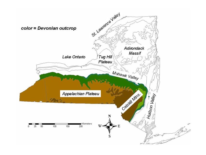
Introduction:

This field guide presents an overview of the Paleozoic stratigraphy of the northeastern
edge of the Appalachian Basin in New York. The area of interest includes portions of the
northern Appalachian Plateau, Onondaga-Helderberg escarpment and Mohawk Valley
physiographic province. In this region, Cambrian through Devonian strata are exposed in
approximately east-west trending outcrop belts, and units dip gently to the south-
southwest at ~1 degree. Natural bedrock exposures are found in stream valleys or along
valley walls in steep, glacially-carved terrain. Wisconsin-age glacial deposits are thickest
in major valleys and mantle many upland areas. The prominent east-west trending
Onondaga-Helderberg escarpment provides the best natural exposures. Road cuts are
numerous along major highways including US Route 20 and Interstate Route 90
(although access is limited). Active and abandoned bedrock quarries in the area are
reasonably abundant.

Bedrock structural features are relatively uncomplicated in the western portion of the area
of interest. In the central and eastern Mohawk Valley, approximately north-south
trending normal faults are evident and bound horsts that were active during Ordovician
and early Silurian time, and acted to control sedimentation patterns during the evolution
of the Taconic foreland basin. Associated syndepositional and early post-depositional
folding and faulting are common in interbedded limestone-shale facies. In the eastern
Mohawk Valley and adjacent northern Catskill Mountains, subhorizontal thrust structures
are present as decollement surfaces within ductile dark shale units in the Ordovician and
Devonian section.

Depositional Sequences:

Potsdam-Beekmantown: The basal Paleozoic strata in the Mohawk Valley region consist
of subarkosic arenite and quartz arenite of the Potsdam Formation, which rests in
profound non-conformity on 1100 ma rocks of the Adirondack Grenville Province. These
basal clastics are succeeded by dolomitic limestone and dolostone of the Galway, Little
Falls and Tribes Hill Formations. The middle Cambrian to lower Ordovician units,
comprising the Beekmantown Group, form a relatively thin (150-600 feet) passive
margin sequence in the Mohawk Valley Region. Inliers of Beekmantown units are found
within normal-fault bounded valleys of the southern and central Adirondack Mountain,
suggesting that the Adirondack uplift was covered by marine waters during
Beekmantown Group deposition. The Potsdam Formation and overlying carbonate strata
thin to the north and west in the Mohawk Valley region, and are not present in the Tug
Hill region, where late Ordovician Black River and Trenton units rest unconformably on
Proterozoic basement. Beekmantown strata thicken to the south-southwest of the
Mohawk Valley region. Early middle Ordovician Chazy Group strata, present in the
northern Champlain Valley and Ottawa-St. Lawrence Lowlands, are absent from the
Mohawk Valley. Post-Beekmantown uplift of the region resulted in subaerial erosion
and meteoric alteration of the early Ordovician passive margin. This “pre-Black River”
or “Knox” unconformity is attributed to progressive east to west regional uplift related to
forebulge development during the onset of the 450 ma Taconic Orogeny.
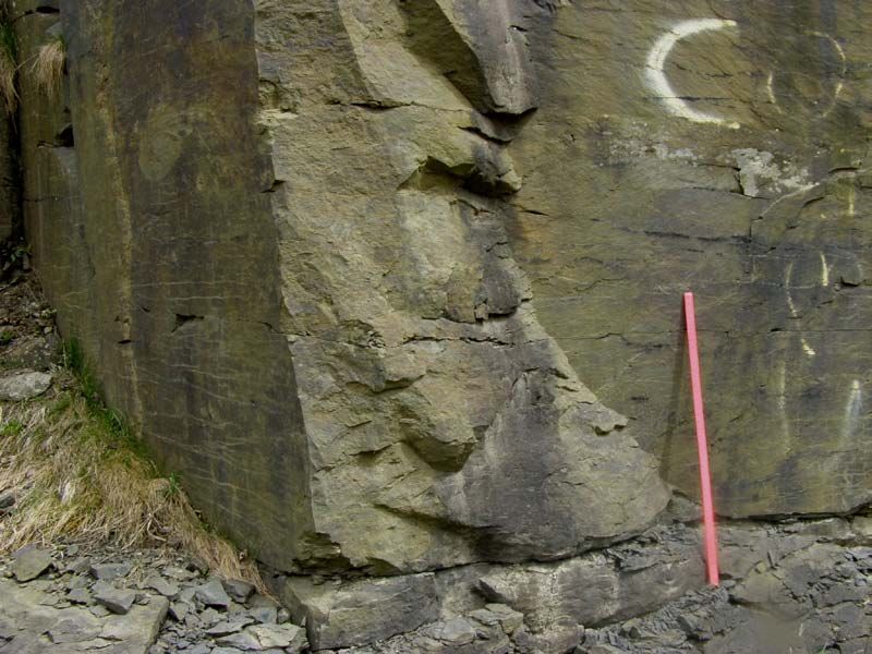
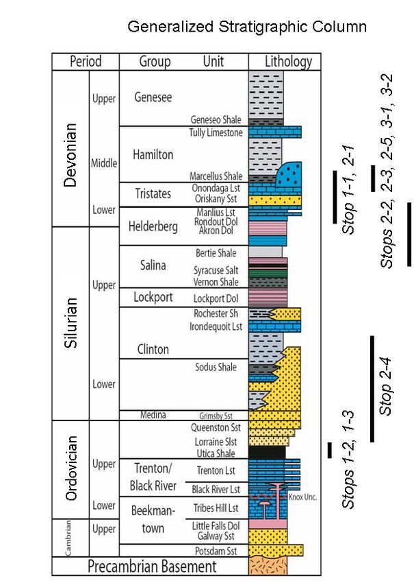
Figure 1: Generalized stratigraphic column in the Appalachian Basin of New York
Black River-Trenton-Utica-Frankfort: Limestone strata of the Black River Group are
present throughout the Mohawk Valley and represent resumption of carbonate deposition
in peritidal and shallow subtidal platform environments during the earliest phases of
foreland basin subsidence associated with the onset of the Taconic Orogeny. Volcanic
ash beds are widespread in the Black River Group and document eruption of andesitic to
rhyolitic stratovolcanoes along the maturing Taconic arc system. The succeeding
Trenton Group carbonates accumulated as the Taconic arc margin began to collapse
westward onto the Laurentian margin of present-day western Vermont, Massachusetts
and Connecticut. Early Paleozoic sediments of the old Laurentian shelf and slope were
driven westward onto the passive margin platform. Trenton carbonates consist of
platform, ramp and foreland basin facies that interfinger with, and are progressively
replaced east to west by basinal mud of the Utica Formation. Late Ordovician Frankfort
Formation mud, silt and sand represent rapid filling of the Taconic foreland basin. By the
end of Ordovician, shallow marine deltaic facies of the Pulaski and Oswego Formations
built westward to complete the Taconic tectophase.

Oneida-Clinton-Salina: In the Mohawk Valley, latest Ordovician units (Pulaski,
Oswego) are absent, and Silurian strata rest unconfomably on eroded Frankfort
Formation. The Oneida Conglomerate, Sauquoit Formation, Willowvale Shale, Herkimer
Sandstone and Ilion Shale are thinned proximal equivalents to thicker basinal sequences
found to the west of the Mohawk Valley region. The Oneida and Herkimer are shoreline
facies with local thickness variations that are related to syndepositional faulting. The
Upper Silurian Salina Group, hosting thick evaporite deposits in the Finger Lakes region,
is represented in the Mohawk Valley by thin peritidal carbonates and dolomitic shale
(Cobleskill and Chrysler Formations) in the Mohawk.Valley.

Helderberg: Renewed collisional tectonism in Early Devonian time prompted foreland
subsidence that accommodated the deposition of platform carbonates of the Helderberg
Group. Abundant volcanic ash beds in the Helderberg document eruptive volcanic
activity. Helderberg strata are absent west of the eastern Finger Lakes region, and are
thickest in the eastern Catskills.

Tristates-Onondaga: Clastic units of the Tristates Group are limited to the central and
eastern Mohawk Valley and eastern Catskill regions. Shelf-to-basin shaley limestone,
calcareous shale, siltstone and sandstone of the Schoharie, Esospus and Carlisle
Formations record uplift and erosion of early Acadian orogenic source regions (Phase I
Acadian Orogeny). The Onondaga Formation carbonates accumulated as terrigenous
clastic input diminished in the early middle Devonian, although widespread volcanic ash
input continued.

Marcellus-Hamilton: Deposition of Onondaga Formation carbonates ended abruptly with
foundering of the platform and termination of carbonate productivity. Basal Marcellus
Formation organic-rich mud accumulated as high productivity, density stratified surface
waters rained organic matter onto oxygen-deficient substrates that received very limited
terrigenous clastic input. The Union Springs Member contains the highest organic
content. The Cherry Valley Limestone Member represents resumption of carbonate
accumulation during an episode of oxygenation of bottom waters. The succeeding
Chittenango (=Oatka Creek), Bridgewater-Otsego and Solsville Members of the
Marcellus comprise a sequence of dark gray to gray shales packaged in shallowing
upward half-cycles capped by silty sandstone in the central Mohawk Valley region. The
succeeding formations in the Hamilton Group (Skaneateles, Ludlowville, Moscow) are
not clearly separable in the area south of the central Mohawk Valley, but generally
consist of gray shale, siltstone and fine sandstone with a normal marine fauna. (Note that
this report does not use the stratigraphic revisions of Ver Straetten and Brett (2007) that
raise the Marcellus Formation to subgroup status. These revisions are difficult to
reconcile with older member-level subdivisions of the upper Marcellus Formation, and
hence the older terminology is retained in this report.)

Upper Devonian: In the area south of the central Mohawk Valley, dark marine shales,
siltstones and sandstones of the Genesee Group overlie sandy upper Hamilton Group
facies. The basal Tully Formation consists of calcareous sandstone deposited in a near-
shore tide-dominated shelf system. The uppermost Genesee Group consists of non-
marine fluvial clastics of the Oneonta Formation. The succeeding West Falls Group is
dominated by marine shelf to basin shale, siltstone and sandstone deposited by mixed
storm and turbidite processes.

Field Trip Stop Descriptions

Day 1

Stop 1-1A – Upper Silurian Chrysler Formation and Lower Devonian Helderberg Group
(Manlius Formation and basal Coeymans Formation)

We will stop briefly at outcrops on Otsego Co. Rt. 32 immediately south of the
intersection with US Route 20 to examine tidal flat facies of the Manlius Formation. Key
features here include microbial laminites, small thrombolite mounds, prism-cracked
laminites and rare casts of gypsum crystals. The upper part of the Manlius consists of
bioclastic grainstone tempestites within muddier tidalite facies. The succeeding
Coeymans Formation is a coarser, bioclastic grainstone-packstone dominated by criniod
and brachiopod debris. Rare tabulate and rugose corals are present.

The Helderberg Group carbonate sequence in the Cherry Valley, NY is approximately
300’ thick. The Helderberg thins to the west along its east-west outcrop belt, and west of
Syracuse, NY is present only as erosional remnants bounded by disconformities above
and below.

Stop 1-1B – Lower Devonian Esopus Shale

In the Cherry Valley, NY area, the Esopus Shale and Carlisle Siltstone Formations total
approximately 40’ in thickness. These marine clastic units are correlative to the thicker
Schoharie Formation of the eastern Catskill/Hudson Valley region, and are derived from
the initial uplift of sources areas to the east during Ettensohn’s (1985). Acadian
Tectophase I. The Esopus Shale exposure on NY Route 166 consists of fissile, splintery
gray shale with a very limited fauna. Rare brachiopods and occasional pyritized burrows
are present.

Stop 1-1C – Carlisle Siltstone and Onondaga Formations:

Carlisle Siltstone Formation and Onondaga Formation (Edgecliff, Nedrow, Moorehouse
and Seneca Members)

We will examine the contact of the Onondaga Formation with the underlying Carlisle
Siltstone Formation in roadcuts on the south side of US Route 20 immediately east of the
intersection of Route 20 and Route 166. The Carlisle consists of bioturbated
(“Taonurus”) calcareous and glauconitic siltstone; its upper contact with the basal
Edgecliff Member of the Onondaga is disconformable, and is marked by accumulation of
phosphate nodules and glauconitic sand. The Oriskany Sandstone interval lies within the
Carlisle-Edgecliff contact, but the Oriskany is absent here due to pre-Onondaga erosion,
or non-deposition. The Oriskany is sporadically present in outcrops in the Mohawk
Valley area, and thickens to the south in the subsurface.

The Edgecliff Member of the Onondaga Formation consists of coarse, bioclastic
grainstones and packstones with bluish gray to white chert nodules. Chert nodules are
often rimmed by dolomitized limestone. Silica for chert in the Onondaga Formation was
provided by opaline silica from sponge spicules. Early diagenetic replacement of
carbonate sediment by opal-CT and later aging to quartz was accompanied by local
dolomitization. Surface waters during Onondaga deposition may have been enriched in
silica from widespread deposition of volcanic ash. Coral, crinoid, bryozoan and
brachiopod fossils are common in the Edgecliff.

The Nedrow Member of the Onondaga is a shaley bioclastic packstone-wackestone-
mudstone with a limited brachiopod-dominated fauna. The Moorehouse Member
consists of medium bedded packstones and wackestones with thin shale interbeds
common. Moorehouse Member chert nodules are dark in color and are rimmed by
dolomite. The Seneca Member of the Onondaga is a bioclastic wackestone-mudstone.
Chonetid brachiopods in the Seneca are often hematite-stained, suggesting possible
subaerial exposure of the Onondaga platform prior to deposition of the Union Springs
Member of the Marcellus Formation. Alternatively, the hematite staining may be due to
later burial diagenetic processes. The total thickness of the Onondaga Formation in the
central Mohawk Valley is approximately 120’.

Stop 1-1D – Union Springs, Cherry Valley and Chittenango Members, Marcellus
Formation

Exposures immediately south of US Route 20 on County Route 34A provide one of the
area’s best opportunities to examine the Union Springs Shale, Cherry Valley Limestone
and overlying Chittenango Shale Members of the Marcellus Formation. The Union
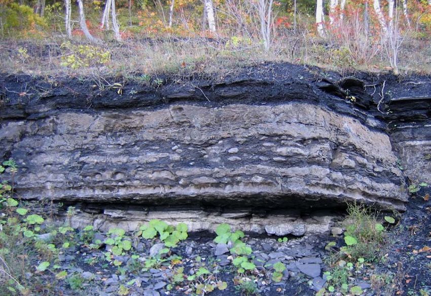
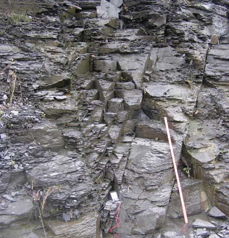
Springs hosts a 10-20 cm subhorizontal shear zone consisting of phacoidally-cleaved
calcite-veined shale. Depending on the outcrop quality, this shear zone may not be
exposed. Fabrics in the shear zone indicate northwest transport of the upper plate. The
presence of this shear zone may explain the deformation of the overlying Cherry Valley
Limestone and the poor development of tectonic joints in this outcrop. The high TOC
Union Springs Member is approximately 25’ thick.

The Cherry Valley Limestone at this locality is 5-8’ in thickness, and consists of dark,
bituminous limestone and nodular limestone in black shale. The limestone beds contain
an abundant but poorly-preserved cephalopod fauna. The Cherry Valley Some beds
consist of styliolinid wackestone; rare brachiopods and auloporid corals indicate that
bottom waters were, at times, oxygenated during Cherry Valley deposition. The
overlying Chittenango Member consists of dark silty shale, and is relatively poorly
exposed at this locality.

Figure 2: Cherry Valley Limestone Member overlain by Chittenango (=Oatka Creek)
Shale Member at Stop 1-1D

Stop 1-2 – Ordovician Utica Shale (Dolgeville and Flat Creek Members) at Town of
Minden Highway Garage

Bedding plane exposures of the uppermost Flat Creek and overlying Dolgeville Members
of the Utica Formation are nicely displayed in the bed of Otsquago Creek immediately
northwest of the Town of Minden Highway garage on NYS Route 80. Both units include
calcareous shale, and siltstone and dark lime mudstone that emit a hydrocarbon odor
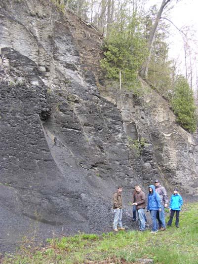
when broken. The lime mudstone beds of the upper Dolgeville contain laminae rich in
pyrite.

Of particular interest in this exposure are the numerous fractures and veins. The most
abundant fracture sets trend ~N70W and N15E and are often mineralized with
hydrocarbon-stained calcite. Note the variation in fracture density in dark limestone
versus the silty and shaley lithologies. Fluid inclusion and stable isotope study of calcite
veins from nearby localities suggest the vein-mineralizing fluids were derived internally
from dewatering of host sediment.

Fracture systems in the Utica Shale Formation in the Mohawk Valley and Tug Hill
outcrop belts are currently under study. In general, mineralized fractures are limited to
the eastern and east-central Mohawk Valley, where E-W Mode 2 (strike-slip) fractures
are most common, and veins occupy dilational jogs associated with this E-W fracture
system; N-S extensional veins are also common in the eastern Mohawk Valley. Both
fracture sets are associated spatially with bedding-parallel thrust faults with calcite-
chlorite slickenline surfaces. In the western Mohawk Valley outcrop belt, Mode 1
(extension) fractures in the Utica Shale Formation are less commonly mineralized except
in the most carbonate-rich lithologies. In the western Mohawk Valley and Tug Hill
Plateau region, the early (J1) joint set in the Utica is ~N50W; the J2 joints are ~N55E.
The Utica J2 joints are parallel to the J1 joints in the Devonian of central New York
(Engelder, et al, 2009).

Stop 1-3 - Ordovician Utica Shale Formation (Indian Castle Member) near Hallsville, NY

Road cut outcrops on NYS Route 80 approximately 0.6 miles northeast of the hamlet of
Hallsville expose the Indian Castle Member of the Utica Formation. The Indian Castle
here is highly fissile, brittle dark gray slightly silty shale. A prominent lime mudstone
bed mid-way in the outcrop contains trilobite, graptolite and orthocone cephalopod
fossils. Note that the trilobite and graptolite fragments are uncompacted. The lime
mudstone bed contains wispy pyrite laminae.

Mode 1 unmineralized joints in this outcrop include N60W, N85W and N10E sets.
Relative timing of these joint sets has not been established.

Day 2

Stop 2-1 - Oriskany Falls, NY, Hanson Aggregates Quarry. Helderberg Group, Oriskany
Sandstone Formation, Onondaga Limestone Formation, Marcellus Shale Formation (note
that hard hats and safety glasses are to be worn at all times).

The Oriskany Falls Quarry at the intersection of NYS Route 26 and Green-Vedder Road
exposes the Lower Devonian Helderberg Group (Manlius, Coeymans and Kalkberg
Formations), the Oriskany Sandstone (type section; approximately 12 feet in thickness),
the entire Onondaga Formation (Edgecliff, Nedrow, Moorehouse and Seneca Members)
and the basal Marcellus Formation (Union Springs and Cherry Valley Members;
exposures depend on state of working at this active quarry).

The working face of the quarry consists of Helderberg and Onondaga carbonates
separated by the prominent tan-white band of Oriskany Formation. Note the absence of
Esopus and Carlisle Formations here. The Oriskany disconformably overlies Helderberg
Group carbonates, demonstrated by erosional and solution truncation of bedding at the
top of the Kalkberg Formation, and phosphate and glauconite clasts in the basal
Oriskany. The Helderberg carbonate sequence thins rapidly to the west from this location.
The Onondaga Formation is likewise in disconformable contact with the underlying
Oriskany Formation, with the basal Edgecliff Member bearing clasts of phosphatic
sandstone. The Oriskany is discontinuous in the east-west outcrop belt from the western
Mohawk Valley through the Finger Lakes region of New York.

The upper quarry level exposes the contact between bioclastic, slightly shaley mudstones
of the upper Seneca Member of the Onondaga Formation and black to brownish black
shales of the basal Union Springs Member of the Marcellus Formation. Depending on
the current state of stripping of overburden, the contact can be directly observed, and the
overlying Cherry Valley Member may also be exposed. Abundant blocks of the units are
also available for inspection. Of particular interest here, if exposure permits, is a
décollement zone developed within the Union Springs Member, and the fracture systems
and mineralization associated with the deformation.

Stop 2-2 Bridgewater West roadcut. Bridgewater, Solsville and Pecksport Members

A road cut on the north side of US Route 20 near the intersection of Bliven Road and US
Route 20 exposes the upper Bridgewater Member and Solsville Member of the Marcellus
Formation. The overlying Pecksport Member is exposed in a stream cut in the wooded
area immediately north of the east end of the road cut.

The sequence here is typical of the upper Marcellus Formation in the central Mohawk
Valley region. These shale, siltstone and fine sandstone units thicken rapidly to the east,
with the combined Bridgewater-Solsville interval exceeding 500’ in the area south of
Cherry Valley, NY. The Bridgewater Member in this outcrop consists of gray, shaley
siltstone with abundant ‘Taonurus’ feeding traces. Body fossils are exceeding rare in this
interval, possibly reflecting biotic exclusion due to the highly unstable substrate produced
by the burrowers. The contact with the overlying Solsville Member is gradational, with
subtle but regular increases in grain size and bedding thickness up section. Vertical
burrows and larger brachiopods (Spinocyrtia) are characteristic of the calcareous siltstone
and fine sandstone of the Solsville. An interval of hummocky cross-stratified fine
sandstone with leached shell coquinite occurs 8-10 feet below the summit of the
Solsville. The uppermost beds contain rare tabulate corals, large brachipods and bivalves
in burrowed muddy sandstone. The upward shallowing and coarsening of the Solsville is
terminated by an abrupt transition to fissile silty gray shale of the basal Pecksport
Member. The flooding surface at the top of the Solsville is marked by phosphatic debris
including phosphatized brachiopod bioclasts and phosphatic intraclasts.
Fluid inclusion and stable isotopic analyses of primary shell carbonate and void-filling
spar cement from the Solsville Member at this outcrop suggest that maximum
temperatures during burial reached at least 140 C, based on aqueous fluid inclusion
homogenization in calcite. Aqueous fluid compositions were near seawater in salinity
during early primatic calcite cementation, but show stable isotopic trends characteristic of
basinal fluid evolution (i.e. the waters became isotopically enriched during later burial).
Calcite cement in tabulate coral voids is strongly growth-zoned, with hydrocarbon-
stained coarse spar cement zones following early prismatic calcite. Later, coarse, clear
ferroan calcite spar fills most remaining void space, and poikilitic calcite cement is
common in the coarser facies of the Solsville.

Joint surfaces in the Solsville Member are nicely displayed at this stop. The J1 (~N60E) J2
(~N15W) joint sets of Engelder, et al (2009) are present. Note the apparent truncation of
concretionary masses in the Solsville by J2.

Figure 3. Joints in Solsville Member of Marcellus Formation. Note concretion cut by
fracture (red arrow). Stick is 1 meter long.

Stop 2-3 Mower Road Marcellus Formation; Chittenango Member (= Oatka Creek
Member)

Outcrops at the intersection of US Route 20 and Mower Road provided data for the
fracture studies of Engelder, et al (2009). The dark to light gray silty shales of the middle
portion of the Chittenango Member of the Marcellus contain numerous thin (2-5 cm)
beds of ripple laminated calcareous siltstones, probably of storm origin. Fossils are
exceeding rare, and limited to a sparse brachiopod fauna and occasional orthoconic
cephalopods.

A zone of fracture intensification is present in the outcrop on the south of Route 20 and
east of Mower Road. These joints may represent conjugate shear fractures related to
either J1 or J2 events.

Figure 4a. Mower Road joint orientations       Figure 4b. Zone of fracture
(from Engelder, et al 2009)                    intensification, Mower Road outcrop
                                               (N60E and N15E orientations). Rod is 1
                                               meter long.

Stop 2-4A - Moyer Creek and South Moyer Creek near Frankfort, NY. Frankfort
Formation (‘Upper Utica’)

Moyer Creek exposures include upper Utica and Frankfort Formations and the erosional
contact between the upper Ordovician Frankfort Formation and overlying Oneida
Formation. We will make at least two stops in this interval. The first stop is an informal
parking area near the lower bridge over Moyer Creek on NYS Route 171 (Gulf Road).
The stream cut immediately adjacent to the parking area exposes Frankfort Formation
silty shale with interbeds of ripple cross-laminated fine sandstone of storm-turbidite
origin. A north-dipping normal fault with ~2 feet of displacement is well-displayed near
the base of the outcrop. Note the fault-related extension fractures in the footwall. Joints
in the Frankfort Formation at this site trend ~N50 W and ~N15E, with the NW fractures
apparently the earlier set.
Stop 2-4B – Moyer Creek and South Moyer Creek near Frankfort, NY – Frankfort
Formation, Oneida Formation (please be very wary of traffic when crossing roadway)
The Silurian Oneida Formation consists of coarse sandstone and conglomerate resting on
eroded upper Ordovician Frankfort Formation at this locality. Note the coarse quartz
pebbles, and pyritized and phosphatized clasts in the basal Oneida. The contact
documents the cessation of foreland basin deposition related to the Ordovician Taconic
Orogeny, uplift and erosion of the foreland, and subsequent subsidence and marine onlap
during early Silurian time. Upper Ordovician Oswego Sandstone, present in the Tug Hill
region to the west, was eroded here, or never deposited, prior to Oneida deposition. The
Oneida Formation represents a thinned, eastern shoreline facies equivalent to the Medina
Formation in western New York State. The succeeding Sauquoit, Willowvale and
Herkimer Formations are nearshore and shoreline facies that are age-equivalents of
thicker basinal units of the Clinton Group in west-central New York. Silurian units thin
rapidly from to the east, with lower Devonian strata resting on deformed Ordovician
rocks in the central Hudson Valley.
Joints are well developed in the Frankfort Formation (~N10W and N35E). Did these
joints develop prior to uplift and erosion of the Frankfort, and deposition of the overlying
Oneida, or was the entire sequence subject to the same fracture history?
Figure 5a. Normal fault in Frankfort Formation at Figure 5b. Oneida Formation
Stop 2-4A. overlying Frankfort Formation at
Stop 2-4B
Stop 2-5 Upper Marcellus Formation Pecksport Shale Member near Hamilton, New YorkThe Pecksport Member of the Marcellus Formation is exposed in outcrops on the west side of the intersection of NYS Route 46 and NYS Route 12B ~4 miles north of Hamilton, NY. The Pecksport Member at this locality consists of moderately fissile gray to dark gray silty shale and siltstone with a low diversity brachiopod/gastropod fauna. The irregular bedding and lack of lamination suggest that the muddy sediment was intensely bioturbated prior to burial. This exposure presents an opportunity to assess whether one can distinguish between early ‘burial tectonic’ fractures (J1 and J2 of Engelder, et al, 2009) and later fractures related to unroofing. Note the curving patterns formed by what may be the latest fractures. Day 3 Stop 3-1 Swamp Road near Morrisville, NY. Marcellus Formation, (Chittenango Member = Oatka Creek Member) The middle portion of the Chittenango Member of the Marcellus Formation is exposed in this roadcut on Swamp Road approximately 4 miles north of the Village of Morrisville, NY. The basal part of the interval consists of dark, silty shale with a very low diversity brachiopod fauna. The succeeding gray silty shale and siltstone contains a progressively more diverse brachiopod and bivalve fauna. Exceptional preservation of primary fossil microstructure is characteristic of shell material from this exposure. Stop 3-2 - NYS Rt. 13 near Cazenovia, NY. Marcellus Formation (Chittenango Member = Oatka Creek Member) This locality on Route 13 forms the type section of the Chittenango Member of the Marcellus Formation. The gray to dark gray silty shale is moderately fissile and contains a very limited brachiopod-orthocone fauna. Small to medium-size concretions (5-30 cm) are present and show modest septarian fractures filled with calcite and rare sulfide minerals. Note that the concretions are not cut by the regional joints, which includes ~N75E (J1) and N5W (J2) fractures. This locality provided data for the fracture studies of Engelder, et al (2009).
Figure 6a. Chittenango joint orientations (from   Figure 6b. Chittenango Member
Engelder, et al 2009)                             outcrop on Route 13 near Chittenango
                                                  Falls. Note curving joint surfaces.

Stop 3-3 Chittenango Falls State Park on Route 13. Salina Group (Syracuse Formation),
Helderberg Group, Onondaga Formation

The exposures in the vicinity of Chittenango Falls State Park consist of upper Silurian
dolostone, dolomitic shale and dolomitic limestone of the Syracuse Formation overlain
by Helderberg Group (Manlius and Coeymans Formation) carbonates and the basal
Edgecliff Member. The Syracuse Formation thickens rapidly to the west, and includes
the evaporite deposits that characterize the Salina Group of central and western New
York. The caprock of Chittenango Falls is formed by the Edgecliff Member of the
Onondaga Formation.
Table 1 - GPS Locations of Stops Stop GPS Easting (UTM GPS Northing (UTM Number Zone 18 WGS84) Zone 18 WGS84) 1-1A 521978 4741289 1-1B 521626 4740616 1-1C 522421 4741131 1-1D 524690 4739690 1-2 529231 4753008 1-3 524975 4753741 2-1 462826 4755440 2-2 475799 4748934 2-3 495387 4746874 2-4A 491514 4763795 2-4B 489626 4762799 2-5 453752 4746051 3-1 445888 4753794 3-2 431554 4756140 3-3 431439 4758739
Bibliography:

BOSWORTH, W., 1984, Foreland deformation in the Appalachian Plateau, central New
York: the role of small-scale detachment structures in regional overthrusting; Journal of
Structural Geology, v. 6, p. 73-81

BRETT, C. and BAIRD, G., 1996, Middle Devonian sedimentary cycles and sequences
in the northern Appalachian Basin. Geological Society of America Special Paper, no.
306, p. 213-241.

BRETT, C. AND BAIRD, G., 2002, Revised stratigraphy of the Trenton Group in its
type area, central New York State: sedimentology and tectonics of a Middle Ordovician
shelf-to-basin succession. Physics and Chemistry of the Earth, Parts A/B/C, Volume 27,
Issues 1-3, p 231-263

ETTENSOHN, F. R., 1985, The Catskill delta complex and the Acadian orogeny: A
model, in D. L. Woodrow and W. D. Sevon, eds., The Catskill delta: Geological Society
of America Special Paper 201, p. 39–49

ENGELDER, T., LASH, G., AND UZCATEGUI, R., (2009) Joints that enhance
production from the Middle and Upper Devonian Gas Shales of the Appalachian Basin;
AAPG Bulletin, vol. 93, # 7, p. 857-889

MCCONAUGHY, D. T., AND T. ENGELDER, 1999, Joint interaction with embedded
concretions: joint loading configurations inferred from propagation paths: Journal of
Structural Geology, v. 21, p. 1637–1652

EVANS, MARK A., 1994, Joints and Décollement Zones in Middle Devonian Shales:
Evidence for Multiple Deformation Events in the Central Appalachian Plateau. GSA
Bulletin, Vol. 106, pp. 447-460.

FAILL, R. A., 1997, A Geologic History of the North-central Appalachians, Part 2,
Silurian through Carboniferous; American Journal of Science, vol. 297, p. 729-761

KAY, G.M., 1953, Geology of the Utica Quadrangle, New York; NYS Museum Bulletin
#347, 126 pp.

LASH, G. G., AND T. ENGELDER, 2005, An analysis of horizontal microcracking
during catagenesis: Example from the Catskill delta complex: AAPG Bulletin, v. 89, p.
1433–1449

LINSLEY, D.M., 1994, Devonian paleontology of New York: containing the
brachiopods, bivalves, rostroconchs, gastropods, tergomyans, ammonoids, trilobites,
eurypterids, and phyllocarids. Paleontological Research Institution, Special Publications,
no.21.
MARTIN, JOHN P., HILL, DAVID, and LOMBARDI, TRACY, 2004, Fractured Shale
Gas Potential in New York, Northeastern Geology and Environmental Science, vol. 26,
no. 1 & 2, pp. 57-78.

NYAHAY, RICHARD E. and MARTIN, JOHN P., 2008, Delineating the Utica
Formation From Outcrop to Subsurface, Geological Society of America Northeastern
Section - 43rd Annual Meeting, 27-29 March.

RICKARD, L.V. AND ZENGER, D. H., 1964, Stratigraphy and Paleontology of the
Richfield Springs and Cooperstown Quadrangles, New York; NYS Museum Bulletin
#396, 101 pp.

SEVON, W. and WOODROW, D., 1985, Middle and Upper Devonian stratigraphy
within the Appalachian Basin. Geological Society of America Special Paper, no. 201, p.
1-7.

VER STRAETEN, C. A., AND BRETT, C., 2006, Pragian to Eifelianstrata (middle
Lower to lower Middle Devonian), northern Appalachian Basin-stratigraphic
nomenclatural changes: Northeastern Geology and Environmental Sciences, v. 28, p. 80–
95.

WERNE, J. P., B. B. SAGEMAN, T. W. LYONS, AND D. J.HOLLANDER, 2002, An
integrated assessment of a “type euxinic” deposit: Evidence for multiple controls on black
shale deposition in the Middle Devonian Oatka Creek formation: American Journal of
Science, v. 302, p. 110–143,

ZENGER, D. H., 1971, Uppermost Clinton (Middle Silurian) Stratigraphy and Petrology,
East-Central New York; New York State Museum Bulletin #417, 58 pp.
You can also read